Utah boasts about 960 miles of US Bike Routes System composed of streets, highway and trails for bicycle use
SALT LAKE CITY, Utah (August 9, 2021) — National transportation officials recently approved more than 550 miles of bike routes in Utah to the United States Bicycle Routes System (USBRS). These newly designated routes enhance safety and ease for biking in Utah.
The routes, approved by the American Association of State Highway and Transportation Officials (AASHTO), now boost Utah’s total USBRS to around 960 miles of streets, highways and trails for rider use throughout the state. Newly designated bicycle routes 77, 677, 877, 79 and 679 now connect riders from Idaho to Arizona in this developing national network of bicycle routes.
“These routes allow commuters, bicycle tourists and leisure cyclists a unique way to travel safely across Utah’s beautiful and diverse landscape,” UDOT Active Transportation Manager Heidi Goedhart said. “As more and more Utahns take advantage of active transportation, we expect to see less traffic congestion, greater economic development, and healthier citizens–three wins for communities everywhere.”
Video of portions of the new Utah route:
Adventure Cycling, a national cyclist advocacy group, partnered with UDOT and Move Utah to develop this north/south, state-to-state route over the last four years. During that time, the group looked for routes that provided riders the most safety and protection, local points of interest, accommodations and bike friendly shops, among others.
Developing the route also required coordination with multiple groups. For example, UDOT coordinated with, and got permissions from, the Departments of Transportation in both Idaho and Arizona regarding state line tie-in locations. Similarly, whenever a route was not on a state road, the group acquired approval and letters of support from local jurisdictions.
There are several benefits that come from the USBRS designation. For example, with this designation, new signs will be installed to direct bicyclists to a preferred route through a city, county, or state. Additionally, the designated routes ensure that a rider’s experience and safety is considered.
“Experiencing Utah by bicycle is a rewarding way to slow down, get off the highway and explore the state’s scenic beauty,” said Vicki Varela, managing director of the Utah Office of Tourism. “These routes demonstrate the commitment of our state and local communities to build something better for both Utah residents and Utah visitors. ”
As part of Utah’s new route system, there are 105 miles of continuous safe and separated cycling trails located along the urbanized Wasatch Front. The route also takes riders along beautiful rivers, parkways and vistas. Not only do these designations help bring bicycle tourism to Utah, but the benefits are also seen locally by assisting in building out and planning other active transportation facilities.
The USBRS application was submitted by UDOT in April of 2021, reviewed in May and approved the same month. To view all national routes, visit adventurecycling.com.
Route Information:
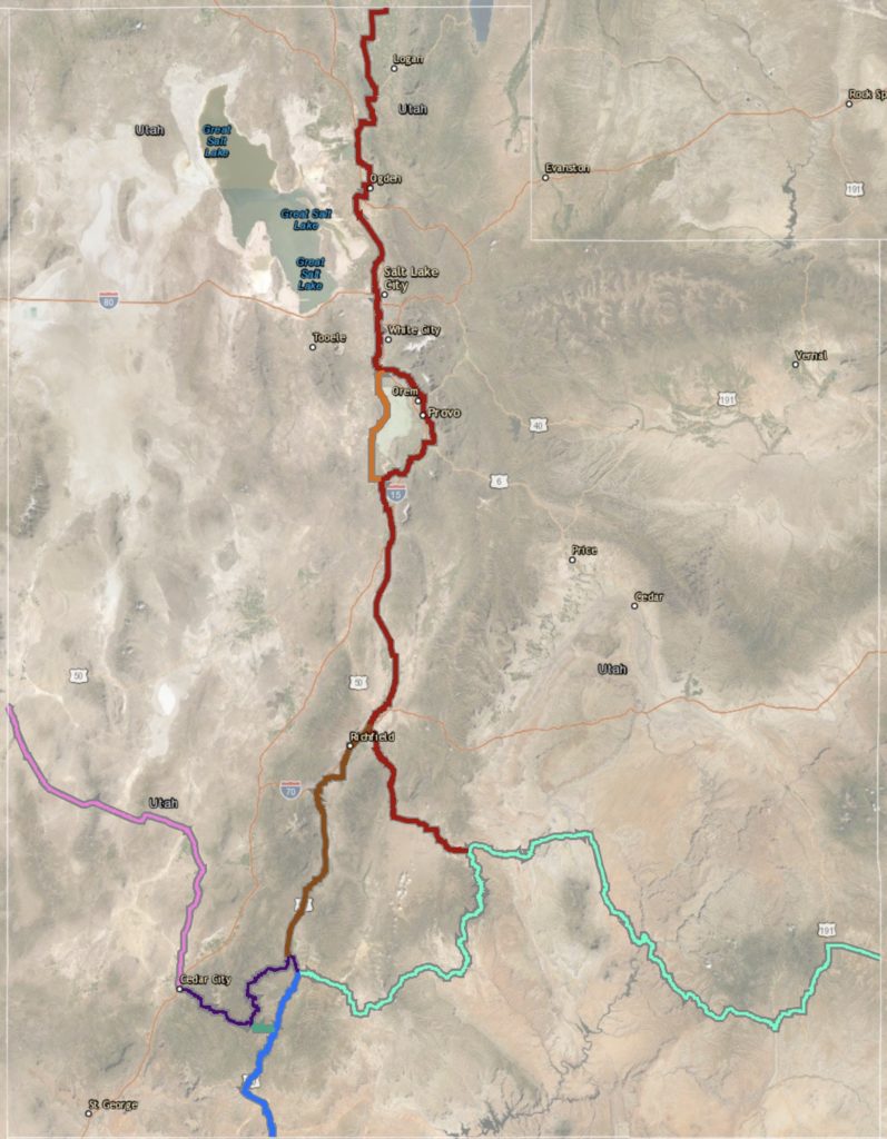
USBR 77, USBR 677, and USBR 877 (349.8, 40.6, and 88.8 miles): USBR 77 begins at the Idaho border and travels through Logan, along the Wasatch Front from Ogden to Salt Lake City and Provo, then climbs between the mountains of the Fishlake National Forest, and continues on to its end at USBR 70 in Torrey, near Capitol Reef National Park. USBR 677 is a less urban and more scenic alternate route on the west side of Utah Lake, while USBR 877 connects USBR 77 in Sigurd to USBR 79 in Panguitch.
USBR 79 and USBR 679 (269.3 and 9.4 miles): From the Nevada border, USBR 79 crosses high desert, reaches Cedar City, climbs toward the painted cliffs and pinnacles of Cedar Breaks National Monument, passes Panguitch, then descends to its end at the Arizona border, in the Navajo sandstone near Kanab. USBR 679 connects USBR 79 at U.S. Highway 89 and USBR 70 at Duck Creek Village.
GPS Route Links:
- USBR 77: Brigham City, Ogden, Salt Lake City, Provo, Torrey
- USBR 677: Alternate off of USBR 77 on west side of Utah Lake
- USBR 877: Connects two USBRs, Sigurd, Panguitch
- USBR 79: Cedar City, Panguitch, Hatch, Mount Carmel Junction, Kanab
- USBR 679: Duck Creek Village