By Lou Melini — An Ontario, Canada bike trip has never been high on my bucket list. It has never come up in conversation except with Julie. I do not know anyone that has toured in Ontario nor read any accounts of anyone touring in Ontario. On the other hand, I have owned “The Lake Erie Connector” maps from the Adventure Cycling Association for several years. The Erie Connector route starts in Michigan, near the Manitowoc (Wi.)-Ludington (Mi.) ferry. The route takes you into Ontario along the north shore of Lake Erie eastward ending in Fort Erie, Ontario. Julie has for many, many years wanted to see Niagara Falls. Her hometown is Manitowoc and Niagara Falls is about a 2-hour ride north of Fort Erie. Despite many conversations over many years, a bike trip to Niagara Falls never rose to the top of the bucket list.
Suddenly, in 2025 Niagara Falls was at the top. Julie’s niece in Wisconsin married towards the end of June. Following the wedding, a bike tour to Niagara Falls seemed plausible except I couldn’t come up with the motivation to plan the trip. The route via the Lake Erie Connector to Niagara Falls and back to Wisconsin would be over 1200 miles necessitating more than 3 weeks for the ride. The other option was transporting Julie and I along with our bikes from Buffalo back to Wisconsin. I was failing with the prospect of planning. Julie stepped up and said she would plan the trip.
Julie did great planning the trip. She thought outside-the-box to come up with an 890-mile loop, cobbling 4 Adventure Cycling routes, (The Lake Erie Connector, The Underground Railroad (Detroit alternative), the Underground Railroad, and the Northern Tier). Julie’s plan started the trip in Avon, Ohio (west of Cleveland) where we left our car with friends of our son Ben who used to live in Utah. We left Avon on June 25th, with our return to our car on July 12th.
We rode a clockwise route with the first day riding to Sandusky, Ohio to catch a ferry across Lake Erie. We worked our way north to Lake Huron, before going to Owen Sound, the most northern city in our travels. From Owen Sound we traveled east and then south near some large cities west of Toronto. The final leg of our Canadian travels had us skirt the south shore of Lake Ontario to Niagara-on-the-Lake. From here we went south to Niagara Falls and our return to the U.S. in Buffalo. The final section of the trip had us in New York, a wee bit of Pennsylvania and back to Ohio and to our car. Eleven days were spent in Ontario, Canada and 5 along the south shore of Lake Erie.
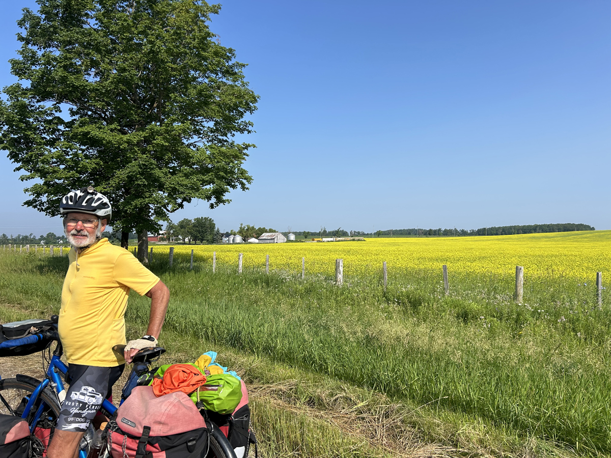
Ontario is one of 10 provinces in Canada, none of which have representation in the U.S Congress or Senate, thus, you need a passport. In addition, check your health insurance coverage. Julie needed to buy “travel health insurance”. Her Medicaid/TriCare health insurance is great in the U.S., but nearly useless outside of the U.S. If you need additional coverage, try Allianztravelinsurance.com or visitorsinsurance.com. For approximately $89, Julie had enough insurance coverage for 2 weeks through Allianz for emergency care and transport to the U.S. My Medicare/UHC health insurance was good in the U.S. and Canada. As a side note, my son traveled to Canada as a mechanic for a race team. One of the team vans went through a different checkpoint. They were told they needed to buy travel insurance or show proof of insurance to enter Canada. The occupants of Ben’s truck were not asked about insurance. Ontario is a very large province; 415,598 square miles large. The combined states of Utah, Idaho, Montana and Wyoming by comparison, are 413,319 square miles. We rode in what I will call the southern, more populated part of Ontario. Approximately 80% of Canada’s population live within 200 miles of the U.S. border and many of that percentage are 2 hours by car from the U.S. Ontario’s major agricultural products include corn and soybeans, wheat, alfalfa, plus other lesser crops.
We rode mostly in the agricultural part of Ontario along roads that bordered large farms. As we approached Niagara Falls, vineyards of grapes became a predominant crop. Much of the bike routes we traveled in the western part of our ride were also signed as the Great Lakes Waterfront Trail, a 3600 Km (2237 mile) community development “trail” in Ontario.
Due to the wedding in Wisconsin, the mid-summer timing for the trip was not ideal. May thru early June or late August to September would have been a better choice. The Midwest and East was hit with a “heat dome” of high temperatures and humidity while we were in Wisconsin. The heat dome continued for the first 2 days of our trip, with the rest of the ride being just hot and humid. We cooled off during one morning of rain that lasted 2 hours when we returned to the U.S. We dealt with the heat with lots of breaks for water and afternoon ice cream whenever available.
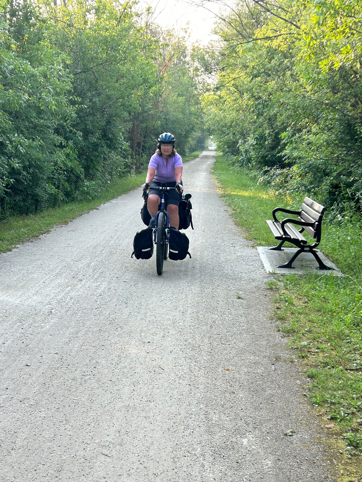
Except for a few miles, the ride was pleasant. We encountered low traffic numbers on the back roads of our route. What traffic we encountered was very friendly including large trucks. In Ontario, cars would pass us after moving to the oncoming lane. We were told that there is a Canadian law that if a car is passing another vehicle, including bikes, oncoming traffic must slow or stop. We found that to be true in all but one case. Most cars and trucks slowed significantly before passing us. Posted speed limits were 50-70 Km/hour (30-45 mph) with a few at 80 and one that I noted 90 Km/h. In the cities 30-40 Km/hr. was common.
In general, traffic safety statistics are noticeably more favorable in Canada than the U.S. according to a recent story in City Lab Daily (The US-Canadian Road Safety Gap Is Getting Wider https://www.bloomberg.com/news/articles/2025-08-13/the-us-and-canada-are-going-in-different-directions-on-traffic-safety).
On the other hand, our back road route had us carrying food longer than our normal routine. Julie and I carry emergency food in the case of an inability to find adequate supplies. Twice we had to resort our emergency supplies. South of Niagara Falls we went out to eat at an Indian restaurant near the campground we stayed at as we were down to some oatmeal and peanut butter though there were navigational issues involved with that meal. The very nice restaurant meal was a welcome change to camp fare.
The Tour:
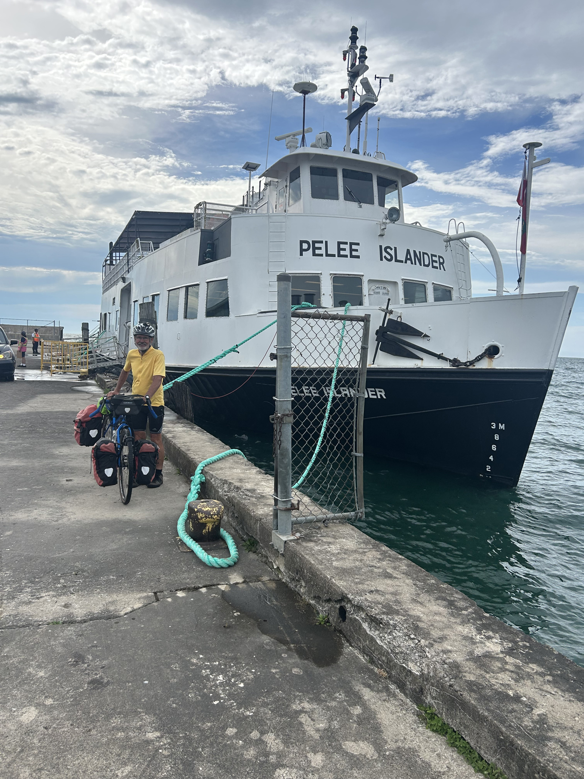
We left Avon, Ohio early enabling us to ride the 48 miles to Sandusky, Ohio to catch the 3:30 ferry across Lake Erie (the alternative being to ride through Detroit). The route to Sandusky was on a flat designated “bike route” on the south shore of Lake Erie. Despite the slow leak from my rear tire, we arrived at the ferry terminal at the designated 2:30 check-in time. Just as we boarded the ferry a thunderstorm hit. We secured our bikes, grabbed necessary panniers and headed into the very well air-conditioned sitting room. Having just ridden in high heat and humidity, I needed to put on my entire rain suit to keep warm, the only clothing that was in my pannier. The 90-minute ferry ride took us to Pelee Island where we would go through Canadian Customs. We camped on the island as the next ferry to the Canadian mainland was at 9 AM the next morning.
The morning 90-minute ferry ride, took us to Leamington, Ontario. From Leamington we encountered our only busy high-traffic road. Like a lot of Ontario roads, there was no paved shoulder, only gravel and stone. We had to ride 10 miles to get off the road and onto the first of many low-traffic roads. Much of that 10-mile stretch was on a gravel/small stone shoulder due to heavy traffic. For the next 2 days we traveled north on flat and relatively low-traffic roads to the shore of Lake Huron. Interesting we camped near Lake St. Clair on our first night on the Ontario mainland. Lake St. Clair allows ship traffic to connect Lake Erie to Lake Huron. It is considered the 6th Great Lake by some, but it is too small in diameter and too shallow to be a “Great Lake” per definition of the Great Lake Commission.
Over the next 3 days we rode along Lake Huron, turning east to Owen Sound. We had a chance to wade in Lake Huron as a couple of our campgrounds were close to the lake. Lake Huron was relatively warm, compared to Lake Erie, with nice sandy beaches. Lake Erie is considered a dirty lake but has better fishing. Riding along this section of the tour was pleasurable. Flat terrain and favorable tailwinds on the low volume roads made our rides comfortable including the first of our two 70-plus mile days. There were some bike trails during this time, mostly a 2-lane pathway on one side of the road.
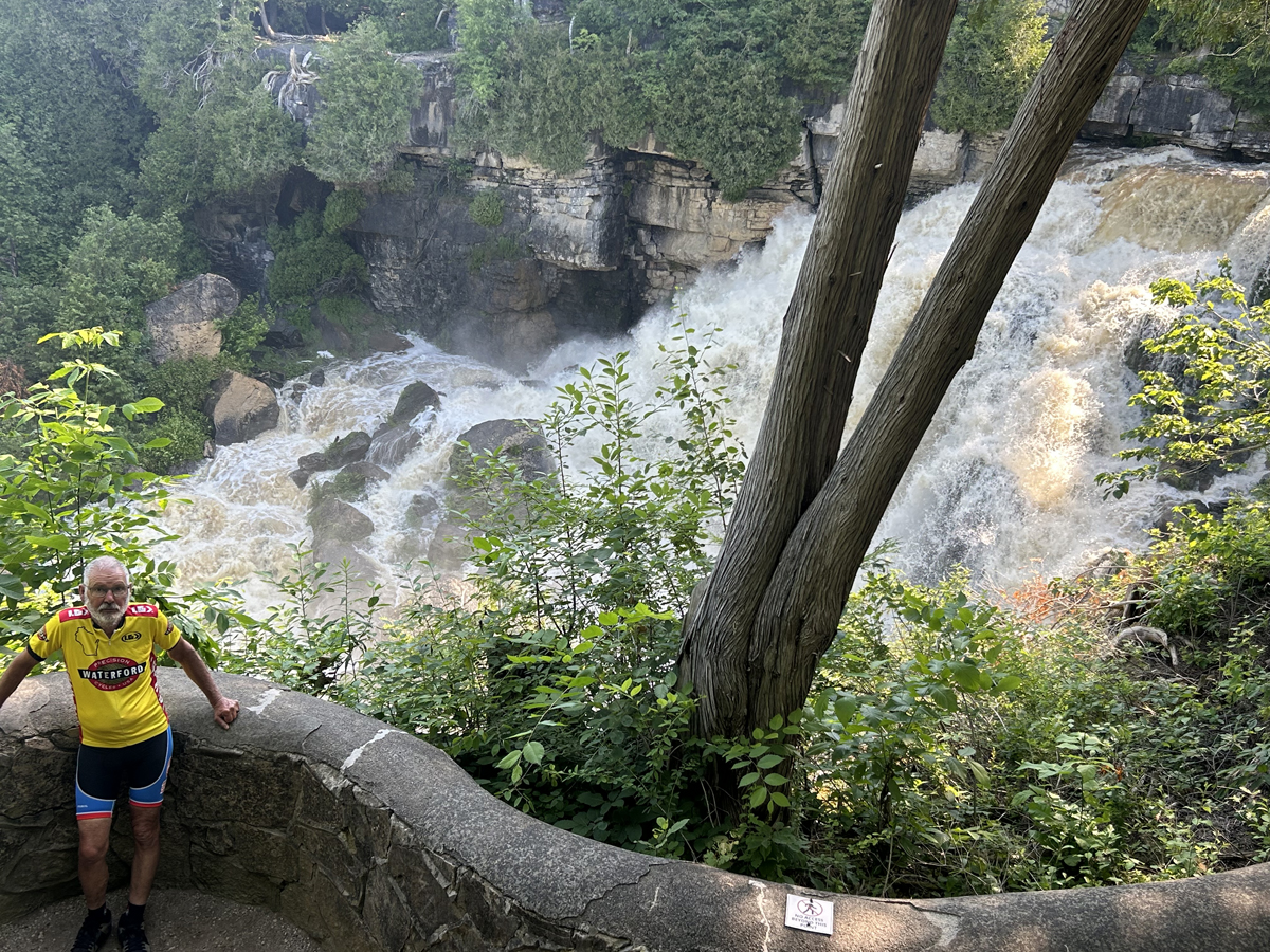
Owen Sound is part of the Georgian Bay which is a branch of Lake Huron. The town of Owen Sound is where we entered a new geologic feature called the Niagara Escarpment. Gentle tilting terrain on one side with steep descents on the other side. There are historical geological reasons for the escarpment that I won’t go into as I am not qualified. However, as a cyclist I am able to authoritatively state that going up the steep descents is damn hard. On my large Ontario map is a 20-30 mile swath of land from Owen Sound to Toronto with pictures of skiers indicating ski resorts. Julie and I were in our lowest gears. I once foolishly missed hearing Julie say “make the next right”. Yep, down I went. I was so pissed at myself I walked more than a quarter mile to return to the missed turn.
Up to this point, Julie and I camped for the past 9 days. Our luck with campgrounds ran out so we contacted a Warmshowers host in Orangeville, Ontario that lies northwest of Toronto. I think it was this day that we did our second 70-plus mile day, equaling my age of 74. We faced some headwinds and a series of steep climbs in the morning on that day. Fortunately, we had a gravel bike trail that was flat for afternoon portion of the ride. The bike trail was not on our maps. We took it figuring it was a rail-trail, thus no hills.
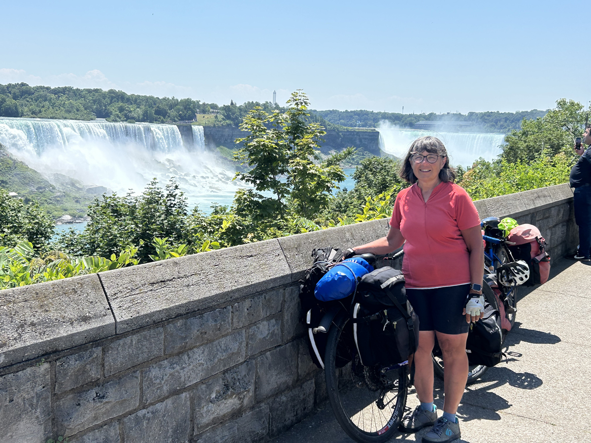
Orangeville was the beginning of a more populated section of our tour route. The Adventure Cycling bike map routed us through this section so that we rode through suburbs and farmland. From Niagara-on-the-Lake, a town on Lake Ontario, through Niagara Falls and until we entered the U.S. in Buffalo, we rode on a paved bike path. Once past Niagara Falls the Shoreline bike path followed the Niagara River. The bike trail was a welcome relief as, expected, traffic picked up near Niagara Falls. After entering the U.S. in Buffalo, N.Y., the terrain again flattened along the south shore of Lake Erie. We did face headwinds during this phase of the trip. Using the digital and print version of the ACA’s Northern Tier route we rode the final 4 days along Lake Erie, including Cleveland back to our car in Avon. Who knew that the route took us to the Rock and Roll Hall of Fame building in Cleveland?
Food and Lodging: Food stores were plentiful in the “larger” cities. There were two small towns that our maps said food stores were available. Both were closed for a couple of years. We once passed a grocery at mile 10 on a near 60-mile day. We did not want to carry dinner for that many miles so we passed it up. Bad decision, as that was it for the day.
We were introduced to peameal at one of our “Second breakfast stops” (about 20 miles after first breakfast in camp). Peameal sounded like a plant-based food. It is a “wet-cured, unsmoked back bacon made from trimmed lean boneless pork loin rolled in cornmeal found mainly in Ontario.” It was very good and added to my eggs and potato breakfast.
We camped for 13 nights and used Warmshowers hosts twice. The Canadian dollar is worth about .73 U.S. dollars. We paid $50-70 Canadian for most campsites, one was $80, and one was $100, though there is a side story to that campground. We rented a cabin at one campground as they “did not do tents”. The owner/wife alluded to Julie that “young people stay in tents and party too late at night”. Julie called on one campground to make reservations stating that we were on bikes and needed a tent site. Before Julie could finish her request, the person bluntly told her that we could not be accommodated. After that we stopped calling, figuring it was easier to show up and obtain a site. When we entered Canada, we did not know that it was “Canada Day” weekend. Canada Day is July 1st. The campgrounds were crowded, but always had room for us.
Using a Garmin unit: This was our first time using a Garmin unit for travel. Adventure Cycling Association has partnered with Ride with GPS (RWGPS) that we downloaded onto the pricey Garmin unit. Less popular routes are now only available in digital format from Adventure Cycling Association. Julie had the Garmin on her bike and I had good paper maps for the U.S. portion and the first day in Canada. I also had an Ontario map with very little detail. The learning curve for the Garmin was steep and frustrating for Julie. I assumed that all of Adventure Cycling data transferred to RWGPS would be up to date. As mentioned, a couple of critical groceries were closed, one very nice rail trail was not on the map, and 3 road closures were not known to us. Only one road closure cost us much time. The Shoreline Trail in Buffalo had construction on the trail or close to it. We spent 90 minutes re-routing through Buffalo yet only traveling a little over 8 miles. How bike routes become updated is a laborious effort and in part is dependent on bike travelers to report discrepancies which I have done in the past and when I returned from this trip.
The Garmin also did odd things to us, perhaps due to our inexperience with it. In Canada, not the U.S, the Garmin would simply turn off when we went off route. In the U.S. it would direct us back to the route (not very well in Buffalo). On too many occasions Julie would signal or call to me “right turn” only to say “no, straight ahead at an intersection”. Sometimes when we stopped at an intersection the little directional arrow would spin in 360-degree circles. On many mornings Julie would have to re-enter the route despite having it set the night before. The unit put adventure in Adventure Cycling maps. I might buy remaining Adventure Cycling paper maps for any route I might think about riding just in case that route becomes digital only.
Nuts and Bolts:
Trip description: This trip is the 8th bike tour that Julie and I have done between 13 and 24 days in length. We rode 890 miles over 16 days.
Start/finish: Julie and I like loop tours to ease travel logistics to our start point and car. We started and finished in Avon, Ohio, a small town west of Cleveland about 8 miles from Lake Erie. The purpose of the trip was to have a bike trip to Niagara Falls. However, seeing the great lakes was an added bonus.
Major points on the loop: The purpose of the trip was to have a bike trip to Niagara Falls. Following that we rode along the Niagara River, a very large river. Seeing the great lakes was a bonus. Finishing the first day of the trip and starting the second day of the trip (total of 3 hours) gave us a sense of the enormity of the lakes. Though difficult to ride, the geographic escarpment gave us a geologic dating back to the last ice age. Geography is one thing, riding the escarpment is a whole different matter. My personal highlight of the loop we rode is simply the ability to travel 890 miles, in Canada and partly in the U.S., comfortably despite having zero knowledge and background of the area we rode. My thanks to the Adventure Cycling Association for making the trip possible.
- Number of days: 16
- Date of the trip: Late June to mid-July
- Total miles: 890
Logistics: In addition to the Garmin, we used Google maps. However, for whatever reason that sometimes became both frustrating and hilarity. “Grocery near me” was 40 miles away, and Ice Cream shop resulted in a store in Kentucky. Google did help us navigate in several situations when we were off route and finding valuable alternatives such as the bike path that was not listed as an option on RWGPS. We had too many items needing to be charged; hearing aids, Garmin, I-pad, Apple watch, and 2 phones. Julie bought and brought with us a unit that had 6 charging ports for plugs, USB, etc. It proved to be very convenient and at one large campground that was extremely devoid of electrical outlets for the number of campsites, a necessity. One of my hearing aid wires broke so I used my backup battery aides for the final week lessening one item needing charging.
Warmshowers: A network of cyclists that host other cyclists in their homes. See: https://www.warmshowers.org
Equipment: We did not use anything special. We did bring front and rear lights that attached to our helmets assuming that we would experience morning fog near the lakes. This fortunately only occurred once with the fog lifting after an hour. We also used the helmet lights during the time we rode in the rain. We used the same tires that we used on our 2024 Alaska tour because we were under the assumption that there were a few gravel roads on our route. Julie rode with 45 mm Pirelli Cinturato H tires and I had 35 mm Cinturato M tires. None of the roads were gravel but the tires were great when we were on gravel shoulders and on the gravel bike trail. The asphalt on the rural roads had many cracks and small potholes so our tires were good in those instances.
Weather: As mentioned, the June-July weather was hot and humid. I think on one day we drank all 3 of our 20-ounce bottles on our bikes 3 times, plus morning and evening liquids. We would lay our sweaty, wet clothing out as much as possible in hopes of drying before putting the clothes in our panniers.
Canada: Everyone was friendly, helpful, and accommodating. We were as polite as possible. Not once did I mention that I was obtaining a piece of Canada when we purchased a campsite. Restrooms are called washrooms. Sometimes convenience stores didn’t have either. The ice cream was great. During Canada Day (a long weekend affair), Canadian flags were displayed everywhere. Some stores stated that “due to tariffs, American products were no longer being stocked”. Learn your metric system as speed limits and mileage signs are in kilometers. One day I got confused when Julie said “20 miles to our destination”. Eight miles down the road I saw a sign that said “20” to the town we were going to. I almost asked Julie to explain herself when I remembered the 20 was in kilometers.
Bike shops and camping supplies: There were bike shops in some of the larger towns we were near. We fortunately did not need any bike shops. I carried too much fuel in part because we cooked less fuel intensive meals. I did not see any stores that sold fuel for my stove except for Walmart. Walmart sells Coleman fuel, but many are out of stock when I have looked. My decision to carry 2 weeks of fuel was good.
Final thoughts: For every bike trip that I do, ideas for new trips pop up in my mind. Of the 5 Great Lakes, Lake Superior is now the only great lake that Julie and I have not ridden along. Perhaps for another day.