By Don Scheese – “So at dawn we were on the edge of a vast malpais…. It was a maze. Ye’d run out upon a little promontory and ye’d be balked about by the steep crevasses, you wouldn’t dare to jump them. Sharp black glass the edges and sharp the flinty rocks below. We led the horses with every care and still they were bleedin’ about their hooves. Our boots was cut to pieces. Clamberin’ over those old caved and rimpled plates you could see well enough how things had gone in that place, rocks melted and set up all wrinkled like a pudding, the earth stove through to the molten core of her. Where for aught any man knows lies the locality of hell.” — Cormac McCarthy, Blood Meridian
“Malpais” is Spanish for “bad lands” (pronounced mal-pie-EES). Across New Mexico and other parts of the West are lava flows that blacken and form barriers across the land. One particularly extensive malpais in New Mexico that has been set aside as a National Monument lies just south of Grants in the north-central part of the state. At 115,000 acres it is one of the larger preserved lava flows in the country. Even larger is the El Malpais National Conservation Area, which surrounds the monument on all sides and includes several wilderness areas, offering further protection from any kind of development.

The 2774-mile long Great Divide Mountain Bike Route (GDMBR), which roughly follows the Continental Divide and runs through New Mexico, Colorado, Wyoming, Idaho, Montana, and Alberta, Canada, scrapes across the western edge of the malpais. Actually, it runs on both sides of the lava flow, the main route to the west and an alternate route to the east (more on that in a bit).
In late April 2025 I decided to bike around the malpais following the GDMBR, on a three-day bikepacking adventure of around 100 miles. Starting from the town of Grants I would make a counterclockwise loop to the southwest through Zuni Canyon, then follow the Chain of Craters Backcountry Byway if it were passable (the main route of the GDMBR), completing the loop by returning on highway 117 back to Grants on the paved alternate road.
The winter of 2024-25 had been extraordinarily dry in New Mexico as a result of La Niña and climate change. Since there had also been no recent rainfall in central New Mexico, I was hoping that the 35-mile-long Chain of Craters Backcountry Byway was dry and thus passable, since any amount of precipitation turns the red clay soils into peanut butter gumbo. A few phone calls to the National Monument and other locals confirmed my hunch. So, I loaded up my vehicle with bike, bags, gear, and enough food for three days and set off on I-40 for Grants.
Where to park the car was the next question. New Mexico (as in many socioeconomic categories) ranks first (or last) in the country in the USA for vehicle theft, so I wanted to park in the safest place possible. I’d called ahead to an RV park about leaving a vehicle there for several days, but the guy I’d talked to was uncooperative, citing liability concerns. Across the road was a KOA so I asked the attendant there. He said yes, but it would cost $90. Highway robbery, but I bit my tongue and paid the fee, at least relieved that I could return knowing my vehicle was there and intact upon completion of the trip. (Later I learned that another RV park in Grants, which also has a brewery, caters to cyclists and would have let me park there for a nominal fee. Lesson learned, too late as usual.)

The first leg of the route took me up Zuni Canyon, which begins as a paved road, then turns to a good gravel surface with an easy gradient of 2-3%. Colorful limestone and sandstone bluffs hemmed me in as the road twisted like a snake through the widening defile. The only problem with the route was dust stirred up by passing vehicles traveling (at least to my way of thinking) way too fast. At the first major junction I paused and, after consulting the map, decided to take the road less travelled by—and it made all the difference. Cibola National Forest Road 447 was smooth and lightly traveled, and though it was a longer route to my intended destination for the day, Ice Cave and Bandera Volcano where a private campground existed, I found it more solitary and much quieter. Ponderosa pine forest interspersed with tawny mountain meadows provided scenic quietude. I followed this idyllic stretch for about 6 miles before returning to pavement on Highway 53, where I turned west.
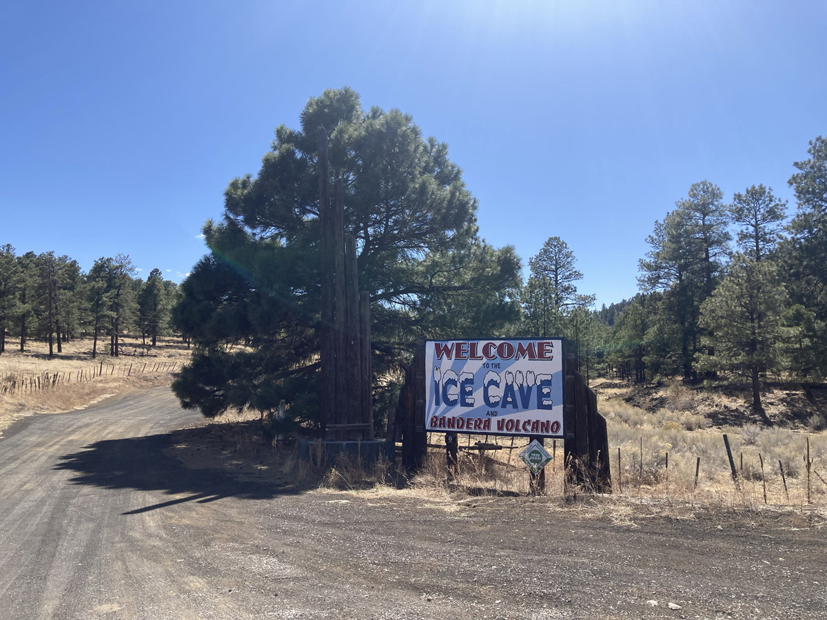
From there it was more good riding with a roomy shoulder and light traffic all the way to the ice caves, the only real challenges being an increasing headwind and steep 1 mile climb up to 8000’ before dropping down to the turnoff. The establishment was a rustic collection of cabins, picnic tables, and hiking trails branching off to the caves and volcano. I paid my fee to the attendant, bought some pop and chips, and set up camp under a sheltered table. The few tourists milling about seemed disinterested in a touring cyclist, and I reciprocated by ignoring them too.
I turned my attention to the malpais, on which I was perched at the very edge. Evil-looking, sharp black chunks of cooled and hardened lava lay just feet from my camp. Yet surprisingly, small oaks and tall pines grew out of the lava flows, and vegetation seemed to flourish in this seemingly inhospitable environment—a conundrum I would witness continuously as I circumnavigated the monument the next few days. As Jack London and Nietzsche observed, nature’s will to survive is astonishing.
After dinner I bundled up against the increasing cold temps and watched bats flit among the pines as stars twinkled through the tree canopy. Because of the extremely dry conditions, no campfires were allowed. Totals for Day One: 38 miles, 2400’ of climbing.
The next morning, after coffee, a pastry, oatmeal and dried fruit, I packed up and set off to return to Highway 53, if only for a short distance. As I was leaving some old grump yelled at me, “Hey you got to pay, this ain’t free camping!” And I yelled back, “I paid yesterday, $31!” All told, I experienced less than a great vibe at this campground. I never did check out the ice caves.
Soon enough I was crossing the Continental Divide at 7882’. Then I dropped down to the turnoff for Cibola County Road 42, otherwise known as the Chain of Craters Backcountry Biway. Upon returning to gravel and dirt, I came across a sign which warned of impassable road conditions if the surface were wet. Since the area (and much of New Mexico) had not received precip in weeks, I proceeded onward, soon entering a shady ponderosa forest. Glimpses of the malpais and numerous volcanic humps, or “cerros” (Spanish for hills), appeared through the tree cover.
Around 600,000 years ago, a series of eruptions occurred, creating some thirty volcanic peaks and blanketing the high desert plain with thick, sticky lava. In some places the magma piled up, forming the cerros for which the El Malpais is well-known: Cerro Candelaria, Cerro Hueco, Cerro Colorado, and so forth. The black lava field roughly forms a rectangle stretching south from Grants to Highway 117, an area 10 miles wide and 20 miles long. Over the centuries vegetation has somehow managed to gain a foothold across the malpais, creating a stark contrast between geology and biology, black lava and green coniferous forest. Again, epitomizing the principle of the will to survive.
This inhospitable landscape was inhabited on its fringes and visited some 10,000 years ago by Neolithic peoples whose descendants eventually became known as the Puebloans. 80 miles to the north lies Chaco Canyon, which from 950 to 1350 AD became the center of one of the most sophisticated prehistoric societies in North America.
Sometime around 1400 A.D. the Navajo migrated from what is now northern Canada to the Four Corners region, becoming uneasy neighbors of the Puebloans. Just to the north of the malpais rises 11,301’ Mt. Taylor, which is considered sacred to the Navajo, Acoma, Hopi, Laguna, and Zuni people. In the Navajo cosmology Mount Taylor was created by First Man from soil from the Fourth World and sacred matter. It is associated with the direction south, the color turquoise, and is considered female. The supernatural beings Black God, Turquoise Boy, and Turquoise Girl are said to reside there. As part of the Navajo Creation Story, the Twin War Gods killed a giant named Yé’iitsoh (Big God) on Mount Taylor, and his blood running down the slopes hardened to form the lava flows of El Malpais.
One of Chaco’s Puebloan satellite communities was established just southeast of the malpais and is known as the Dittert Site, named after an archaeologist who excavated it in the 1940s. Architectural likenesses between Dittert and other Chacoan sites confirm it was one of the outliers of the Chacoan society, inhabited sometime between AD 1000 and 1300, then abandoned due to a serious, prolonged drought.
Today this site and other cultural areas in the malpais are visited by Acoma, Zuni, and other Puebloan tribal members as sacred places. A 7.5-mile trail, called the Acoma-Zuni route, follows a prehistoric trade pathway connecting the two pueblos across the northern part of the monument. It crosses four major lava flows and is also part of the Continental Divide trail.
As I continued my ride, I couldn’t have asked for much better riding conditions. The road surface mostly consisted of smooth, “champagne” gravel. I was proceeding down a gentle gradient all the way to Highway 117. There was only a slight headwind. And temperatures were a tolerable 60-70 degrees. I made good time, eventually spilling out onto a treeless plain, passing several ranches, wells, and windmills creaking in the breeze. At the highway junction I stopped for lunch and noticed a lone hiker setting off north on the Continental Divide trail, a monstrous pack on his back, no doubt carrying gallons of water. I didn’t envy his mode of transport one bit.
My initial plan had been to camp somewhere near the junction, but the terrain couldn’t have looked more uninviting. I was making good time and distance and knew that the paved highway to the north continued to descend gradually all the way back to Grants. Since it was only early afternoon, I kept on riding. And as I did, the geology changed dramatically.
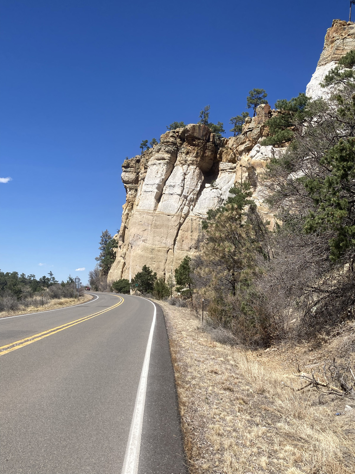
Well, at least one side of it did. To the west still lay the formidable barrier of the malpais. But to my immediate east soared colorful sandstone bluffs hundreds of feet above the desert plain. Soon on this little-trafficked highway I passed the Narrows, where lava once flowed beneath the base of the bluffs, forming a small corridor through which human traffic threads. Some ten miles farther down, now enjoying a brisk tailwind, and needing a break from the searing sunlight, I stopped in the parking lot for the trailhead to La Ventana Arch, one of New Mexico’s largest natural arches. I lay on top of a picnic table under a shelter as a few tourists passed by, who stayed well clear of the grungy, smelly cyclist. Exactly the way I preferred it.

Another five miles or so I arrived at Joe Skeen Campground, a BLM recreation site. I was more than happy to snag a good site late afternoon, with a picnic table, shelter, and fire ring (complete with a pile of ready to ignite firewood). My timing was excellent, as within an hour the campground filled to capacity. A few late arrivals looked woefully on as they passed by. One guy in a beat-up, noisy diesel van with Alaska plates pulled into my site & assumed he could camp there for the night, but I quickly informed him this was not possible. So, he circled his way around the campground, and later I could hear him bellowing from across the way, bending the ear of some unfortunate good Samaritan.
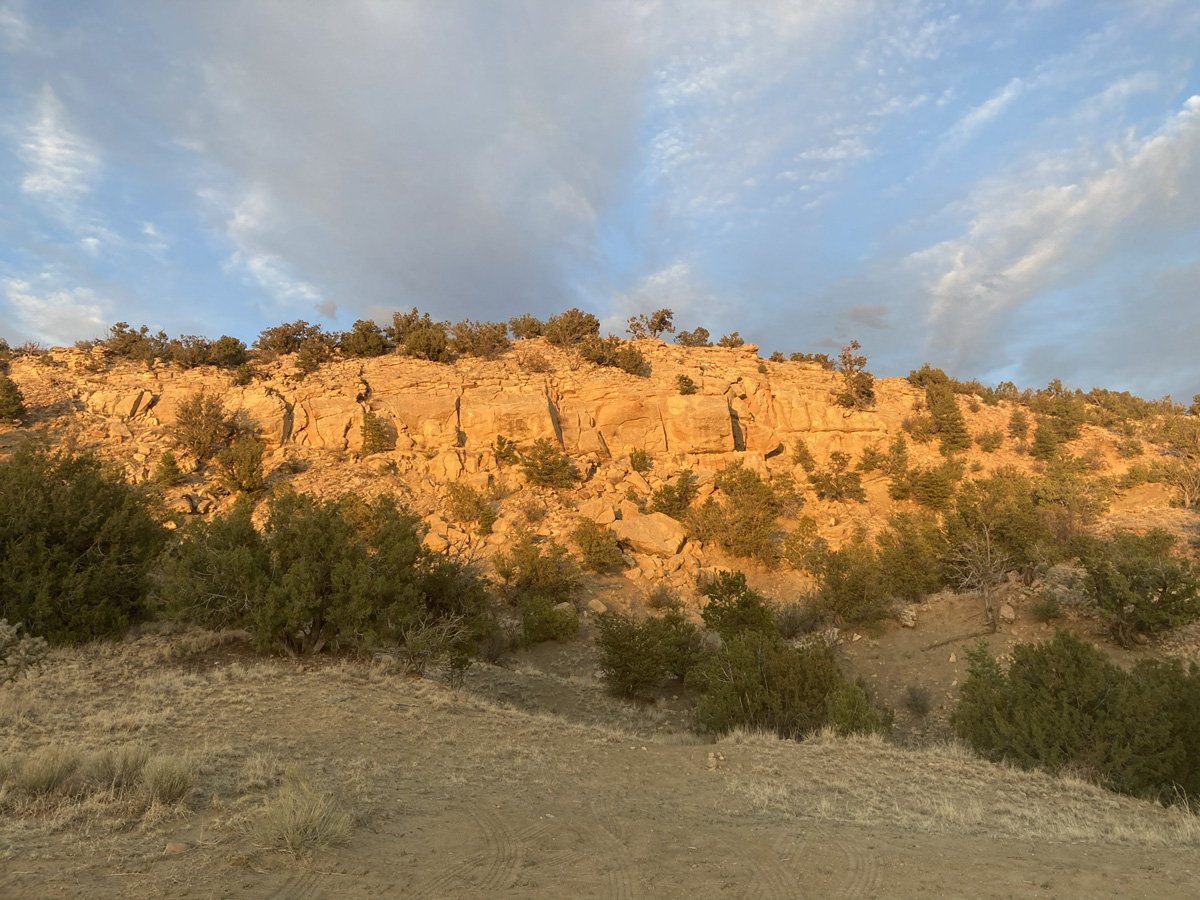
I enjoyed a peaceful night around my fire. The setting sun beautifully illuminated the bluffs behind my camp, and soon stars began to twinkle in the dark desert sky, capping a good day of riding: 58 miles, 1024’ of climbing.
I was out of water after breakfast. But three miles farther down the highway was the El Malpais Ranger Station, where water was available. I took advantage of the facilities to clean up a bit, chat up the friendly ranger, and tour the exhibits in the visitor center, where I learned the distinction between two different kinds of lava: A’a, fast-moving lava, and Pa’Pa, slow-moving (because much of vulcanology initially occurred in the Hawaiian Islands, the terminology is derived from the native language).
Since I was nearing civilization again, I attached a blinking taillight to my Camelbak for better visibility. Farther down the highway I passed two more CDT hikers. “Happy Trails!” I yelled to them, but they did not look very happy, waving half-heartedly back at me, limping along under monstrous packs, again confirming my preferred choice of recreational transportation. I passed over I-25 and turned west onto old Route 66, the famous cross-country artery spanning much of the USA, now falling into disrepair due to the construction of the interstate highway system. A funeral procession featuring tens of motorcyclists roared by, interrupting the high desert quietude.
One last cruel if short uphill climb and I was cruising along on a good shoulder through downtown Grants, sadly passing numerous boarded up storefronts, sketchy motels and other businesses which had seen better days. But the town of Grants still righteously celebrates its Route 66 heritage, and I passed several lovely parks and signs touting its place in highway and mining history.
Traffic thickened on the main drag but was manageable and respectful. As always, the distance on this last day of trundling was longer than expected, but still a relatively short 21 miles and 307’ of climbing. I again crossed over I-25 and soon returned to the KOA where my Outback was safely parked. After unloading, repacking the car and washing up, I headed east back home, having ridden 118 miles and climbed 3600’ total in three days. Not a bad effort on the GDMBR, and already I was thinking of future trips.
Resources:
- Great Divide Mountain Bike Route: https://www.adventurecycling.org/routes-and-maps/adventure-cycling-route-network/great-divide-mountain-bike-route
- El Malpais National Conservation Area: https://www.blm.gov/visit/el-malpais-nca
- El Malpais National Monument: https://www.nps.gov/elma/index.htm
- Chaco Culture: https://whc.unesco.org/en/list/353/
- Road Rides in the El Malpais National Monument: https://www.nmts.org/~nmtsorg/rides/elMalpais.htm