By Dave Campbell – As a boy growing up in Wyoming, the trails, lakes, mountains, and streams all along the Wind River Range’s Louis Lake Road, known locally as “Loop Road” were my family’s playground. My most memorable boyhood adventures happened at its many scenic mountains Lakes. Ruggedly beautiful in a way only the Wyoming Rockies can be, the Loop Road begins and ends in Lander and connects South Pass to Sinks Canyon State Park. From a long climb past a dramatic red sandstone canyon, a gravel road then climbs past numerous mountain lakes and creeks to cross the continental divide before plunging down a gorgeous limestone canyon. Lander sits at 5358 feet of elevation and the high point of “The Loop” occurs at Blue Ridge at 9576 feet. At just over 66 miles long, with around 6000 feet of elevation gain, it is a formidable outing. But the biggest challenge is the gravel between the two highways. From the time I first started seriously riding in the early 1980s, I have wanted to ride it and in 2013 I finally did.

Thankfully, several years prior, the worst of the gravel switchbacks, from Frye Lake to Bruce’s Camp, many deeply wash boarded from braking 4x4s and trucks towing trailers, were paved. This left a stretch of about nineteen undulating miles with 2000 feet of climbing. It was this development that made me believe the ride was possible…but how to set up my road bike? At that time, gravel bikes were still uncommon, and I certainly didn’t have one. All my local cycling friends and the outdoor adventurers I grew up with knew of no one that had ever done the ride and wondered what type of bike would be up to the diverse task. Thirty-five miles on the highway begins the ride with most of it climbing and gaining over 3800 feet. Then comes the gravel which varies dramatically: there are loose and sandy sections, hard packed bone rattlers, and sections with large exposed underlying granite chunks covered with scattered loose stones. Fit and determined, I ultimately tackled the big ride first on a Cannondale Carbon Road bike with the largest tires I could fit (measly 700×25 belted Michelins) and a low gear of just 39/27. Remarkably, I emerged unscathed with nary a flat tire in just under four hours. Strong and naïve, I remember thinking a little lower gear would be nice. Ha! I have since undertaken the ride nearly every summer but now enjoy it much more comfortably on a Moots Titanium gravel bike with 34/50 gearing up front and 11-30 in the back while rolling on 34 mm wide Challenge Strade Bianche tires.
After about eight successful rides now over the years, I can confidently say the best time to tackle this is in mid-to-late June and on a weekday. I have only ridden it clockwise as that puts the hardest climbing on the front end while saving the best descending for the finale. You want to miss the camper traffic as it is a popular recreation destination and steer clear of the days around the Fourth of July! Start early to not only beat the heat but also the wind. The wind tends to blow down from the mountains and typically picks up later in the day. Afternoon showers are possible so pack a light shell. There are gates on either end that close the road during the winter and it usually opens to vehicle traffic by June 15, although bikes can go around the gates and I have even dodged the occasional snow drift over the years. Take two tubes, a pump, and tire booting material, as well as plenty of food and water. Water on this ride can be a challenge, and I have regularly begged off campers and drivers over the years and thankfully they have always obliged.

The first ten miles out of town on US Route 287 are a series of short rollers until the Rawlins Junction. Continuing after the interchange the Highway becomes Wyoming 28 (The Red Canyon Highway) and following a short descent, the long drag up to the spectacularly beautiful Red Canyon begins. Formally designated a National Natural Landmark by the Federal Government, its color and magnitude, even just from the roadside, is breath taking. The summit at Red Canyon is false, though, and a long gradual descent to a plateau forces another long climb back up, this time past Aspen meadows and Beaver dams to Limestone Mountain. If you stop to enjoy the views, consider asking fellow travelers for water as you’ll need it! The wind often picks up here and then the Sirens sing again because despite the many miles of climbing it is not “THE” summit. Another long descent follows down to the old US Steel Iron Ore mine, and the wind can really pick up as the last true climb looms ahead. Roadside signs tell the tale of the Boom and bust that gripped this area during the 1970s. This opening stretch is a great place to see Pronghorn. The last difficult climb on pavement is long, straight, and morale testing and takes you nearly to historic Atlantic City on the left, but you want the Louis Lake Road turnoff on the right…and the gravel.
Here Lander is now 31 miles behind or 35 miles ahead if the loop is completed. The longest climbs are finished and about 2/3 of the elevation has been gained but you are far from home free. A great Forest Service Sign lays out all the obstacles, sights, and mileage ahead. I usually stop and pull on thin over socks to keep the dust out of my well-ventilated shoes and to feel more “euro” on my epic Wyoming Roubaix. The opening two miles of gravel climb over washboard ruts that will rattle your bones and make you question this endeavor as progress is painfully slow. Choose your line carefully, keep the elbows bent, use those low gears, and be patient. Thankfully, the road soon levels out, gets smoother, and the mountain beauty makes it all worthwhile.
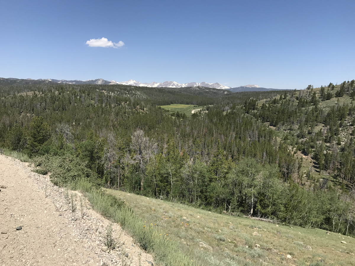
The first big open area is Granier Meadows at just under 8900 feet of elevation. It is beautiful, expansive, and covered in wildflowers. The wildflowers are another reason to get out here as soon as the road is passable. The first views of the peaks of the snow-covered Wind River Range are breathtaking and only get more spectacular as you continue. Surrealistic piles of Shale and Granite appear along Forest Service Road 300. A disturbing number of brown beetle-killed trees stand out amongst the sea of green Lodgepole Pine and Douglas Fir as my childhood frog hunting grounds come into view at Louis Lake. There is a lodge that is typically not yet open in June, but people are usually there prepping the cabins for the season. The owners are friendly and have allowed me to fill my bottles every year.

After crossing the stunning Little Popo Agie River on a quaint wooden bridge, there are more meadows and ponds and the chance to see wildlife. There is another steep and winding climb that dramatically brings the much larger Fiddler’s Lake into view. I used to find this gravel nearly as smooth as pavement but in recent years it has been rugged as the Loop Road no longer seems to be graded by the highway department. Just beyond this popular canoeing and camping site is the old Blue Ridge Fire Lookout. Constructed by the Civilian Conservation Corps, the stone steps yield an amazing view of the high mountain lakes and meadows. The serene and reflective moments at Fiddlers are brief as the steep, bumpy climb up to Blue Ridge itself begins.
The summit is not only the highest point on the ride at 9,576 feet, but also the Continental Divide. From here the road twists and winds down quite steeply and is very bumpy at times. There is significant washboard in spots that require very astute line choice as do the sharp and abundant rocks. Over the years, this is the only place I’ve had issues-bouncing a bottle, dropping a chain, and just once a flat tire. I regularly throw caution to the wind and let it rip when the road straightens out and drops into Worthen Meadows. The vibration is intense, but brief and there is but one more gentle climb on the dirt remaining.
After passing the turnoff to Roaring Fork Lake, the gravel ends dramatically at Frye Lake, where the Forest Service signs announce just 16 miles to Lander on Highway 131, the Sinks Canyon Highway. I regularly let out a whoop of joy here and would encourage you to do the same! Lander is home to NOLS (National Outdoor Leadership School) and is chock-full of rugged outdoor enthusiasts and these are their playgrounds. There is a short climb up to the “top of the switchbacks” as everyone in town refers to them. After that, however, you will drop about 3500 feet in fourteen miles. Just over the top are several fabulous mountain bike and hiking trails, bathrooms, and a parking lot.

The view of the limestone Sinks Canyon below is awe-inspiring as is the five-mile-long descent at 6%. The turns can be taken at 20-25 mph, and you can accelerate up to nearly 40 on the straightaways. The minimal traffic, frequent constant radius turns, and near perfect road surface mean that this is nothing short of a cyclist’s playground. Pure descending gold. At the bottom of the first descent is a trailhead where you need to slow down as hikers cross the road. After this slight plateau, the road drops again at a ranger station and there is a cattle guard where caution is needed, but I have occasionally crossed at fifty mph when the wind is blowing down the canyon. The ensuing eight-mile descent is fast (I’ve hit over sixty mph) with peak speeds by the Visitor’s Center but be attentive as people cross the road here. Tourists feed the trout that gather at “The Rise” of the Sinks-where the Popo Agie River re-emerges after disappearing into limestone caverns further above. The curves of Sinks Canyon are gentle, and the walls of the Canyon flank the plunge until the road levels out. Cattle ranches and cabins now dot the countryside just outside of the lovely little town of Lander and you roll right past the City Park where you can camp for free. I didn’t think much of this place growing up, but I sure appreciate it now! No longer racing, this incredible ride is my fitness focus as soon as the snow melts. I train hard every year just to be able to ride the Louis Lake Road when I “come home” to big, beautiful Wyoming. Check it out, you won’t be disappointed!
Lander Wyoming Travel Information:
Lander Bike Shops:
Gannett Peak Sports
371 Main Street
Lander, WY 82520
307-332-2926
gannettpeaksports.com
The Bike Mill
109 Main Street
Lander, WY 82520
307-335-5435
thebikemill.com
Nice write-up, Dave! Personally, I am partial to riding the loop counter-clockwise, but it’s a great ride either way. It is also worth a mention that you can do a good chunk of this ride (and then some) by racing the WYO 131, which we host the second Saturday of September each year. And thanks for the mention of the shop!