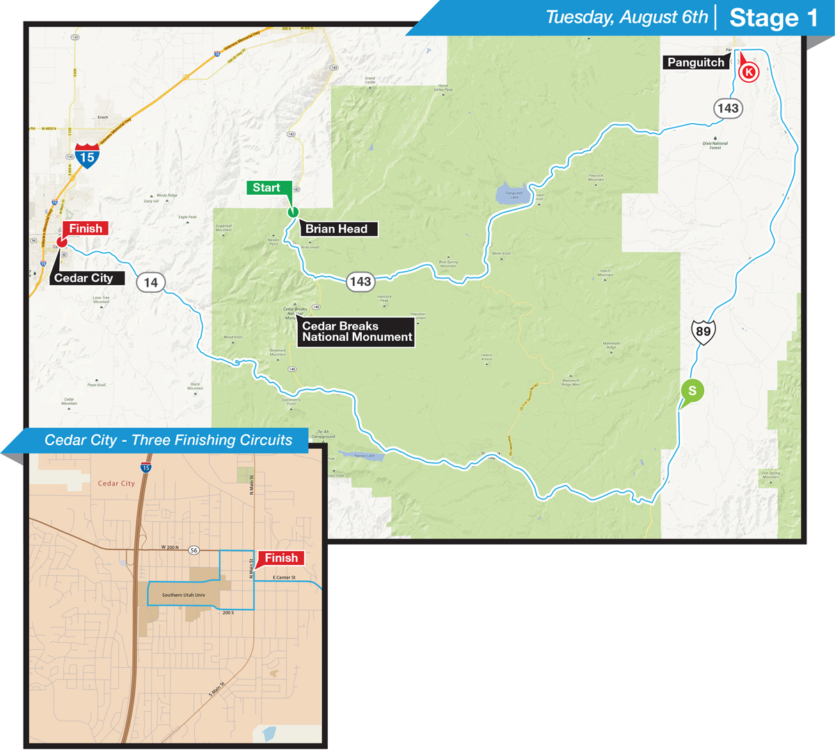
STAGE 1: Brian Head to Cedar City Presented by Zions Bank, August 6 Road Race
Total Distance & Elevation: 112 mi. (180 km); 5,784 ft. (1,752 m)
Start: 11:35 a.m.; Estimated Finish: 3:45 p.m.
Start Location: Brian Head Resort, Giant Steps Lodge
Finish Line: Cedar City; Harding Avenue and Main Street
backcountry.com Lifestyle Expo; Cedar City; 85 N. Main 12 p.m. – 4 p.m.
Where to Watch:
Cedar City will be the place to watch the action. After an 18-mile/ 3000 ft descent of Cedar Canyon into Cedar City, the race will complete 3 circuits of downtown, including Southern Utah University. Get there early to take in the live music and Expo before the exciting sprint finish.
Brian Head Resort hosts the highest elevation of any start city in Tour of Utah history. At an elevation of 9,600 feet at the start, the race heads over to Cedar Breaks National Monument. The start is a great way to see the racers up close with Autograph Alley and Rider Sign-in. Brian Head Resort will have all on-mountain activities for you to enjoy after the race begins. Come up the weekend of August 2-4 for the Festival of Flavors Beer Festival.
Local’s Tip:
After the start at Brian Head Resort, following the race on SR 143 towards Panguitch, but go south on Mammoth Creek Rd. Mammoth Creek is a wonderful area with lava fields and alpine forests. The first KOM of the Tour will be located at the junction of Mammoth Creek Rd and SR 14 in Duck Creek. If you ride your bike, it’s a 50-mile ride with 4,000 feet of climbing through Dixie National Forest, lava fields and through Cedar Breaks National Monument.
Parking:
Cedar City: Spectator parking is on 100 West between 200 North and Center Street. Directions: head South on 100 West from 200 North to can access parking.
Parking is available in the Navajo parking lot at the Brian Head Resort. Race Spectators are not permitted to park in pullouts and trailhead within Cedar Breaks National Monument. Pullouts and trailheads are for the exclusive use of park guests.
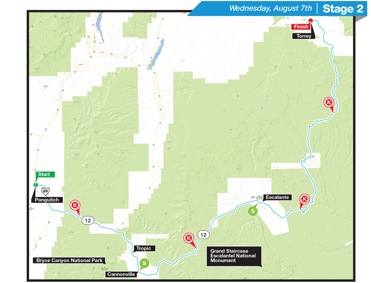
STAGE 2: Panguitch to Torrey Presented by Utah Office of Tourism; Panguitch to Torrey August 7 Road Race
Total Distance & Elevation: 131 mi. (210 km); 9,877 ft. (3,010 m)
Start: 10:00 a.m.; Estimated Finish: 3:45 p.m.
Start Location: Panguitch; Main and 100 North
Finish Line: Torrey; Hwy 24 and Center Street
backcountry.com Lifestyle Expo; Torrey; 49 E. Main 12 p.m. – 4 p.m.
Where to watch:
Spectators can view an XO Communications Sprint Line in downtown Panguitch on August 6 -Stage 1, and the race start of Stage 2 on Main Street on August 7. From Panguitch it’s a short 12 miles drive to Bryce Canyon National Park.
Stage 2 of the Tour traverses famous Highway 12. Along the 131 mile race route, you will find Bryce Canyon National Park, Kodachrome Basin State Park, Grand Staircase-Escalante National Monument, Dixie National Forest, Petrified Forest State Park, the Burr Trail, Anasazi Village State Park and Capital Reef National Park. Pick a location and you can’t go wrong!
Escalante – Boulder
The 18 miles between Escalante and Boulder are some of the most. Start your ride from Escalante. Make sure you stop at Kiva Coffeehouse for a pick me up at one this scenic coffee shop. Pick a spot up on the Hogsback to watch the racers suffer over the knife-edge climb through Utah redrock and Grand Staircase – Escalante National Monument. Finish your ride with a meal at the Burr Trail Café or Hell’s Backbone Grill in Boulder. Escalante will be hosting a Tour of Utah party with food and beer on Tuesday, August 6 at 6 p.m. in front of Escalante Outfitters.
Local’s Tip:
Get out of your car and visit the wonderful towns along the route of Stage 2. Each town has its own unique flavor: You’ll find good eateries in Utah along Hwy 12, including Circle D, Escalante Outfitters, Café Diablo, Burr Trail Café and Hell’s Backbone Grill to name a few.
Several slot canyons and day hikes are located a short distance from the race course. Hole in the Rock Rd in Escalante, Calf Creek, and the Burr Trail in Boulder offer spectacular scenery. Contact a local outdoor shop for tips on available adventures. Escalante Outfitters in Escalante and the Trading Post in Boulder are great options to get the insider’s scoop.
Torrey:
Watch the exciting finish of Stage 2 in beautiful Torrey. Torrey is the gateway to Capital Reef National Park with miles of great roads for cycling. Get a ride in through one of the nations most beautiful and remote National Parks and have time to watch the finish and visit the Tour of Utah Lifestyle Expo.
Parking:
Race spectators are encouraged to visit and park in any of the start/finish or pass through communities. Spectator parking is NOT permitted within Bryce Canyon National Park. Pullouts and trailhead parking within the park are for the exclusive use of park guests.
Stage 3: Richfield to Payson Presented by iOn Camera; Richfield to Payson August 8 Road Race
Total Distance & Elevation: 119 mi. (191 km); 6,202 ft. (1,890 m)
Start: 10:50 a.m.; Estimated Finish: 3:45 p.m.
Start Location: Richfield; City Park; 100 East and 300 North
Finish Line: Payson; Memorial Park; Main Street and 300 South
backcountry.com Lifestyle Expo; Payson; 250 S. Main 12 p.m.- 4 p.m.
Where to watch:
Mt. Nebo will be the place to see the fireworks of Stage 3. Mt. Nebo is the highest mountain in the Wasatch, so escape the valley heat and come up to Mt. Nebo to see all the race action.
Local’s Tip:
Visit the finish city of Payson. Enjoy the lifestyle expo including motorcycle freestyle demonstrations and then ride your bike up the Mt. Nebo Loop. Give yourself plenty of time to climb up this beast of a climb: It’s a 22-mile climb from Payson to the KOM on Mt. Nebo.
Parking: TBD
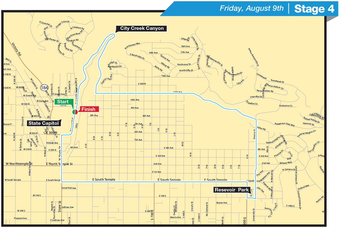
Stage 4: Salt Lake City Presented by University of Utah Health Care; Salt Lake City Circuit August 9 Circuit Race
Total Distance & Elevation; 33.8 mi. (54.7 km); 3,550 ft. (1,082 m)
Start: 5:30 p.m.; Estimated Finish: 6:45 p.m.
Start Location: Salt Lake City; State Capitol; E Capitol Street
Finish Line: Salt Lake City, State Capitol; E Capitol Street
backcountry.com Lifestyle Expo; Utah State Capitol; 350 N State 3 p.m.-7 p.m.
Friday, Aug. 9: Utah Bike Collective will offer a Bike Valet Service at the State Capitol Exp
Where to Watch:
In 2011, State St was lined with thousands of spectators. The major climb of the circuit is up State Street and provides a great opportunity to see the racers up close as they suffer on their way to East Capitol. State St is also a short walk from the Lifestyle Expo.
Reservoir Park: City Weekly Magazine is throwing a party at Reservoir Park which offers an amazing vantage point as the race course touches three sides of the park. Racers will hit close to 60 mph on their way down Virginia on their way to Reservoir Park.
Locals Tip:
A great place to watch the race is on Bonneville Blvd around City Creek Canyon. It is best to ride your bike and pick a shady vantage point. Come up Memory Grove to access this part of the course.
Parking:
Please ride your bike or use local public transportation. A bike valet will be located at the Lifestyle Expo at the Utah State Capitol.
Stage 5: Snowbasin to Snowbird Presented by Utah Sport Commission; Snowbasin Resort to Snowbird Ski and Summer Resort August 10 Road Race
Total Distance & Elevation: 113 mi. (182 km); 10,611 ft. (3,324 m)
Start: 10:50 a.m.; Estimated Finish: 3:45 p.m.
Start Location: Snowbasin Ski Resort
backcountry.com Lifestyle Expo; Snowbird; 100 Little Cottonwood Canyon 12 p.m.-4 p.m.
Finish Line: Snowbird Ski and Summer Resort
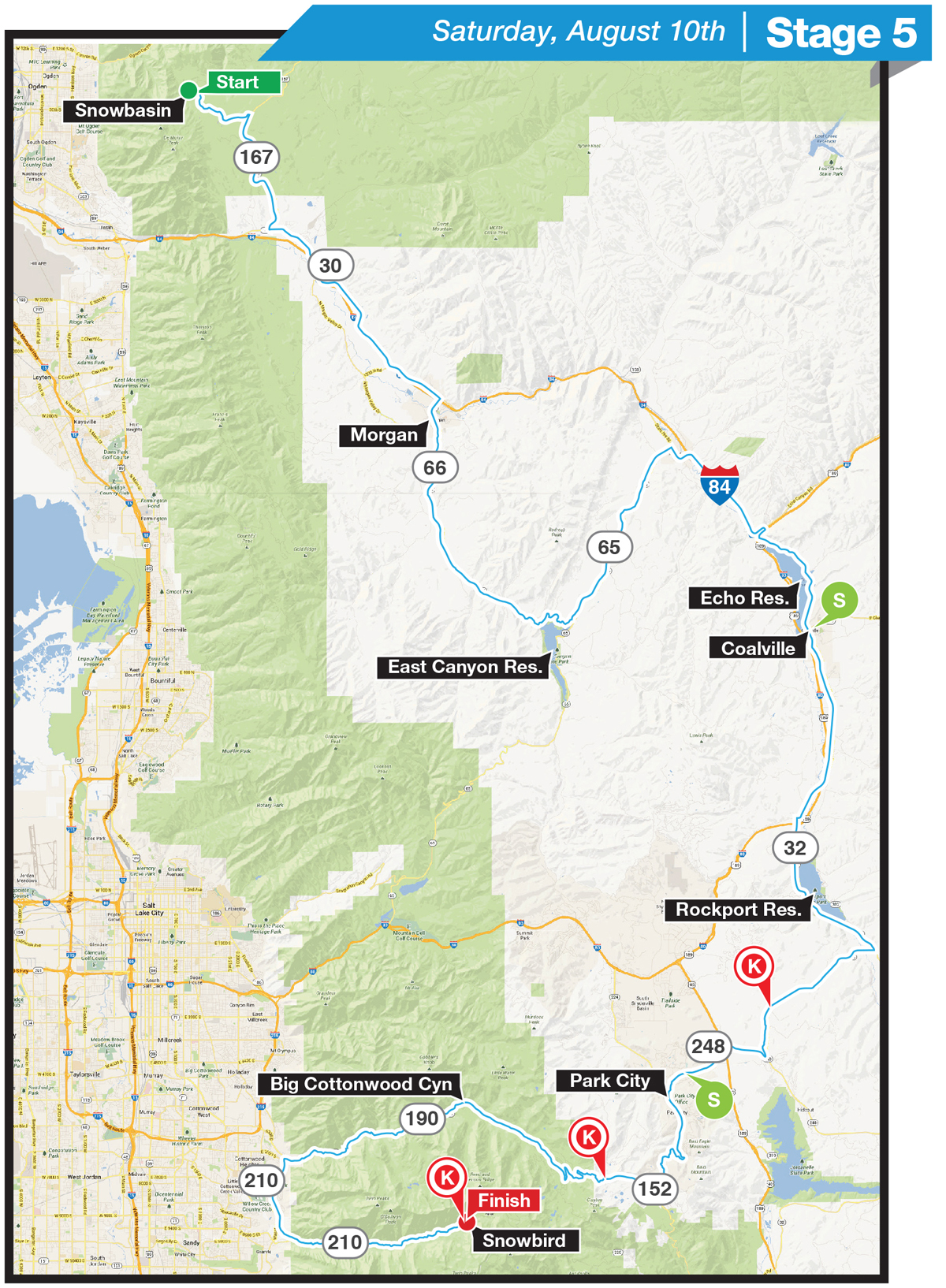
Snowbird/Little Cottonwood Canyon:
Tanner Flats is a misnomer: This is the steepest part of the climb up to the Snowbird Ski and Summer Resort where the party starts early as spectators claim the best spots by early morning. Grab your friends, pack a cooler, wear a costume and head up to the biggest street party of the year.
****Little Cottonwood Canyon will close for uphill traffic at 1:30pm****
Park City:
Known locally as the “Mine Rd,” Marsac Ave (also SR 224) is a relentless climb of 15% grade up to Guardsmans Pass. The Mine Rd is close to Main Street so you can grab a bite and stroll the shops of Historic Park City after the racers pass through.
Local’s Tip:
The best way to see Stage 5 is on your bike. The two climbs of the day will impact who wins this year’s Tour. Ride up to Guardsman’s Pass from Park City or to Snowbird up Little Cottonwood Canyon. This will help minimize traffic and enhance the experience for all spectators – and it’s a great workout.
Make sure you also cheer-on our Ultimate Challenge participants who will be tackling the same course as the pro’s earlier this day.
Where to Park:
Parking will be available at the Snowbird Ski and Summer Resort. It’s best to come early to beat the crowds up Little Cottonwood Canyon. Enjoy the mountain air and all the activities at Snowbird and grab a bite.
Parking is available in Park City on Swede Alley in the parking structure as well at the Flag Pole Lot at the corner of Heber Ave and Swede Alley. Again, parking is at a premium, so park further out of town and ride or walk to the race sites.
Stage 6: Park City Presented by VLCM & Barracuda Networks; Park City to Park City August 11 Road Race
Total Distance & Elevation: 78 mi. (125 km); 7,633 ft. (2,326 m)
Start: 12:15 p.m.; Estimated Finish: 3:45 p.m.
Start Location: Park City; Lower Main Street near Dear Valley Drive
Finish Line: Park City, Lower Main Street near Dear Valley Drive
Backcountry.com Lifestyle Expo; Park City; 650 Main 10 a.m. – 4 p.m.
Sunday, Aug. 11: Cole Sport will offer Bike Valet Service in the Park City Expo.
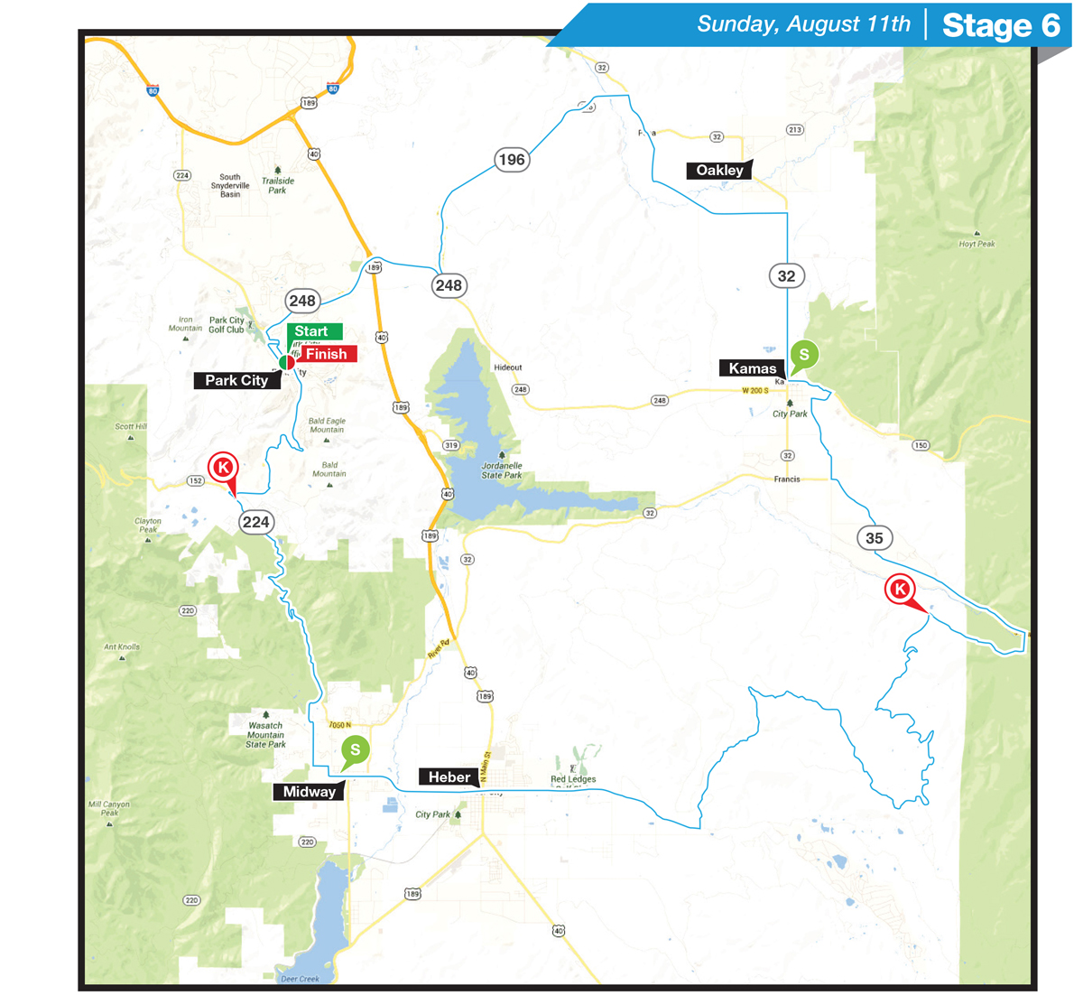
Where to watch:
Last year more than 20,000 spectators packed the streets of Historic Main Street. The Tour of Utah is held in conjunction with the Park City Silly Market; after the racers depart, spectators will have approximately 3 hours to take in the sights and sounds of this mountain town before the racers descend the Main Rd at over 60 mph on their way to the finish on Main St.
Empire Pass
Empire Pass will be the place to watch the racers suffer. Introduced in 2012, Empire Pass has quickly become a legend in American cycling with maximum gradients over 20%, racers struggle on this 10 kilometer climb to Park City.
Locals Tips:
Make a day of it in Park City! After the racers depart at 12:15pm, the finish line will be opened for kids to create “Street Chalk Art” to welcome racers to the finishing stretch of the Tour. The race will take approx. 3 hours to complete, which gives you plenty of time to shop, eat., visit the Silly Market, or go for a ride or a hike.
Parking:
Parking for Historic Main Street will be available at the Park City High School on Kearns Blvd. Shuttle buses will be running from the High school to Main Street throughout the day.
There will be limited parking on top of Empire Pass. Thank you to the Red Cloud HOA for providing spectator parking. Please carpool or park further out and walk/ride in. Don’t forget your water and sunscreen!