“What the Eiger and the Matterhorn were to the climbers of the 19th century, the Galibier and Mount Ventoux have now become to cyclists; to reach the summit is to defy nature and gravity while flirting with the limits of human endurance. The experience is visual, even spiritual, inspiring heroic deeds that in turn inspire poetic portrayals.” —Daniel Friebe & Pete Godling, Mountain High: Europe’s Greatest Cycling Climbs
“Climbing, I’ve come to learn, is more than a physical task. The act of pedaling your bike to the peak of a distant bump on the horizon is transformative.” —Selene Yeager, Climb! Conquer Hills, Get Lean, and Elevate Every Ride
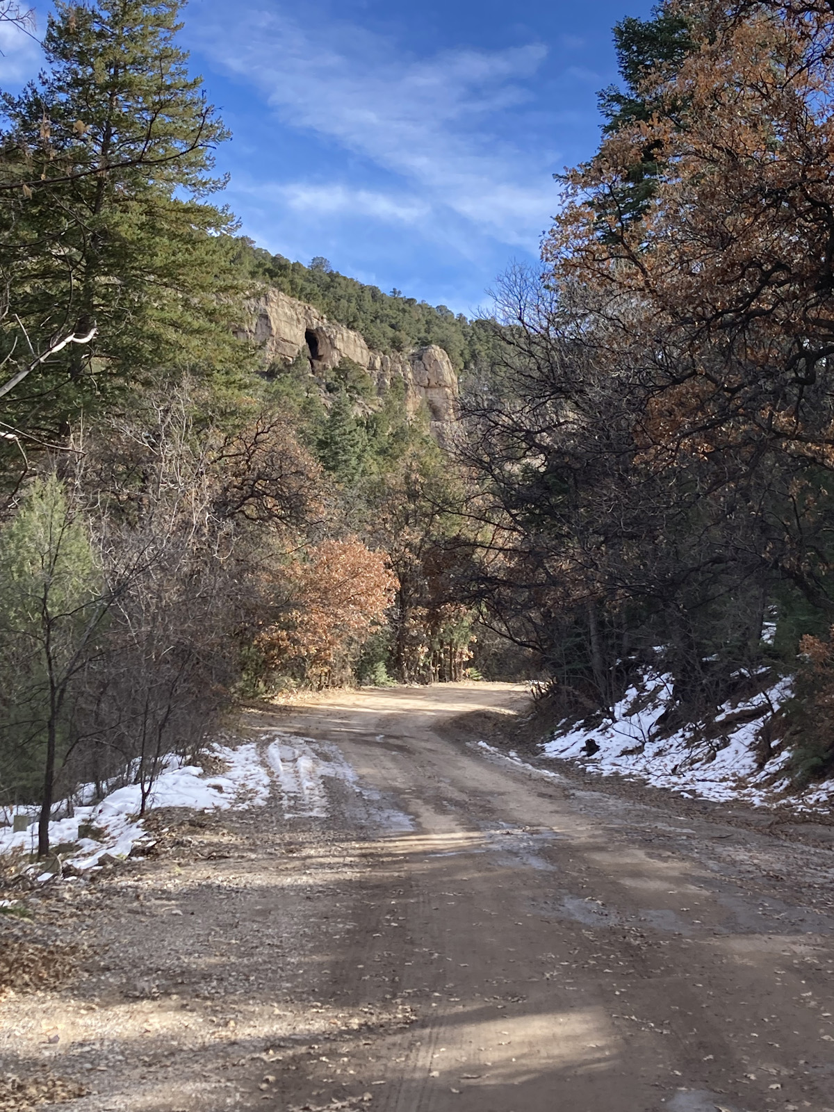
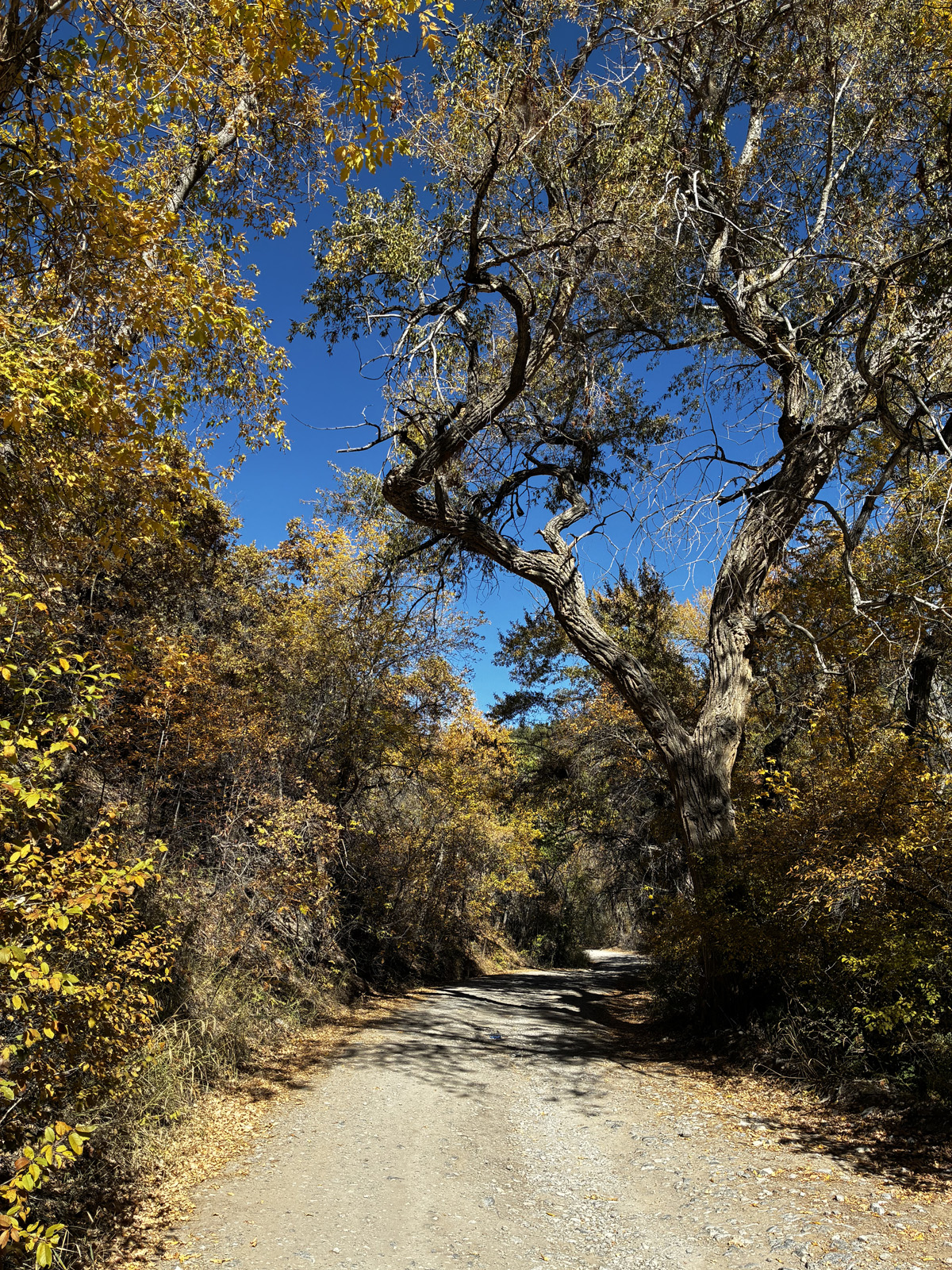
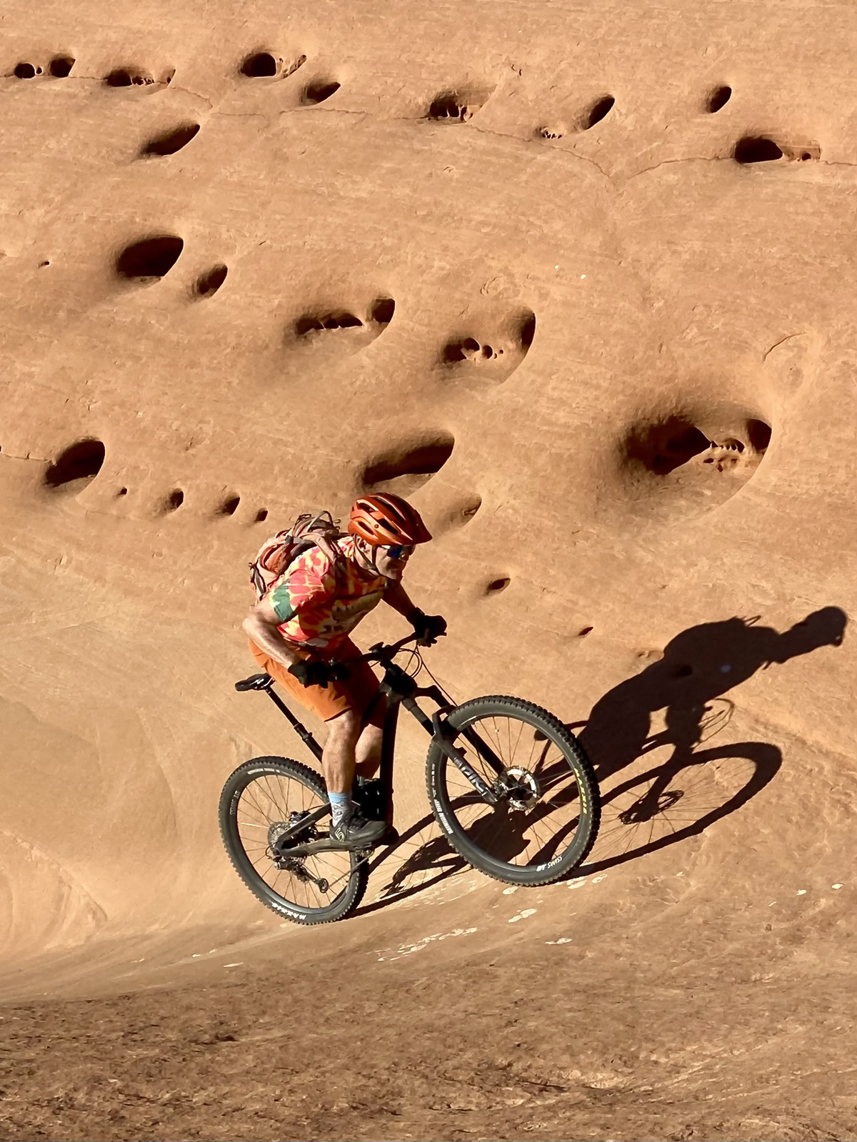
By Don Scheese — Every serious cyclist has a favorite local climb. Mine is from our home at 5700’ in the foothills of the Sandia Mountains outside Albuquerque, up state highway 165 through Las Huertas Canyon. Weather permitting, I ride it (or at least sections of it, depending on snow/ice conditions) virtually every month of the year. With a one-mile warmup thrown in, it’s six miles to the end of the pavement at 6300’, then another eight miles on Forest Service gravel road to paved Sandia Crest Highway at 8600’ (New Mexico state highway 536). Then it’s another five more miles to the top of the Sandias at 10,667’. Total elevation gain: around 5000’. Regardless of the length of my effort, once my tires begin crunching on the gravel section I enter Another World: a world of quiet, lovely, near-total solitude.
The gravel portion of 165 was built in the 1920s by the U.S. Forest Service, allowing access to and from the west side of the Sandias to the eastern slopes of the mountain range. When completed, it promoted tourist traffic for visitors to the greater Albuquerque area in an era when the city, like other major metropolitan areas of the Southwest, was just beginning to experience significant population growth, thanks to the invention of air conditioning. The 8-mile gravel section runs through portions of the Cibola National Forest, and from time to time the agency has considered paving the road. Thankfully such ideas have been dismissed mainly due to local opposition and cost considerations.
Winter
Depending on snowfall (increasingly iffy in these days of Climate Change), I may be able to ride at least partway up the canyon from December through February. How far up varies with the amount of snow and ice on the road. Once past the historic village of Placitas (Hispanic settlement dating back to the 1700s, Anasazi occupation to the 1200s), houses and developments thin out, till I come to pavement’s end and the community’s last homestead.
From here it’s three miles to Sandia Cave at 7000’ and another mile to Las Huertas Picnic Area at 7600’. But at this time of year, I’m lucky if I can reach several landmarks a mile or so below the cave—the large grove of cottonwoods and elms, the big Douglas fir, or the big Ponderosa pine. All these natural features but the last are below bridge number 3, the pine just above (seven bridges total cross the creek on the gravel stretch, all below the picnic area).
Once my wheels begin to crunch on the gravel road, I always find myself breathing a deep sigh of relief and gratitude. The forest—at this elevation, pinyon and juniper trees, with hardwoods like willow and elm along the creek bed—envelops me, and the quiet becomes palpable. This time of year, the creek, one of only two perennial streams in all the Sandias, runs silently underground, the water locked up in snow and ice in the sub-freezing temperatures. As I ascend, I may hear a few birds like mountain chickadees and juncos, but otherwise the canyon remains quiet. There will be a few short sections of road that are snow and ice-covered because they remain in perpetual shade due to the low angle of sunlight in winter and the twists and turns of the canyon, necessitating lower tire pressure and sometimes even studded tires. But mostly the road will be dry and dusty if the precipitation has been light.
The geology changes as I ascend. Cliff faces begin to appear, defining the canyon walls as the defile becomes increasingly narrower. Ridgetops disappear as the horizon closes in. In quick succession I pass bridges #1 and 2, not too steep at around a 4-5% gradient, then settle in for the longer stretch before, conditions permitting, I reach bridge #3. Usually that’s as far as I can climb at this time of year. I pause to rest, drink from one of my bottles, and perhaps munch a bar, taking in the mountain solitude. In winter the chances of encountering another cyclist or a motor vehicle are slim to none. The only annoying reminders of “syphilization” are the graffiti-covered signs indicating road miles and narrowing roads near approaching bridges.
I brace myself for the fast chilly descent back home, then launch off, quickly upshifting to harder gears, though I’ll pedal hardly at all until I reach pavement again.
Spring
Come March, the canyon road is usually snow and ice free (though muddy and sloppy in spots because of the freeze-thaw cycle), so I should be able to make it up to Sandia Cave at 7000’, nine miles from the house. Once I’m close to bridge #3, I can hear the loveliest of noises (especially true in the desert Southwest): the sound of mountain water. The creek emerges above-ground around the location of the Big Doug fir, fed by melting snowpack and tributary springs.
The Cave is a site of some controversy. Back in the 1930s it was excavated by an archaeologist from the University of New Mexico who claimed to have found artifacts dating back 25,000 years, making it the oldest site of human occupation in North America. Thus, the legend of “Sandia Cave Man” was born. But over the decades closer scrutiny of the “evidence” proved that certain artifacts had been planted. Nowadays it is generally agreed upon that some of the archaeological evidence dates back 10,000 years—still a significant discovery. Nonetheless, like any good apocryphal tale, the legend persists and draws the occasional tourist up the canyon. A half-mile trail to the cave leads to a metal staircase ascending to the mouth of the alcove where visitors can peer into its shallow depths. I have even found the blankets of intrepid spelunkers inside who apparently spent a night or two there. Mystery attracts the curious like bees to a honey pot.
It was near the cave that a tragedy unfolded. Some years back a woman disappeared while hiking in the area. The first time I came up the canyon I noticed “WHO KILLED CARLA?” signs plastered on trees. Her remains have never been found, and now a descanso—a gravesite with white cross and artificial flowers—is a sobering reminder of civilization’s worst tendences creeping up the canyon on occasion.
The next mile up to the picnic area is the steepest and toughest section of the entire eight-mile gravel road. It’s rutted, rocky, and at its most challenging the gradient rises to 13%. After pausing at the cave for a break and refueling, I remount the bike and push on. Having passed bridges # 4 and 5, the creek now lies on my immediate right-hand side where I observe pools and tiny waterfalls through the willow-lined banks. I once came across a Native American harvesting willow branches here, maybe for use in fashioning baskets. Ever the vigilant birdwatcher I look for but have never seen an American dipper poking and splashing in the creek. Yellow-rumped warblers are occasionally present in the later spring months at this elevation, before the hardwoods leaf out and shade the canyon road, obscuring their presence. Once I even spotted a goshawk in the leafless treetops, patiently waiting for prey to emerge in the adjacent meadow.
Grinding away in my lowest gear (30-42), I cross bridge #6, grinding away past several primitive campsites along the creek. Here the road is at its steepest and rockiest. Rounding a right-hand bend, I pass an imposing granite cliff face and take on the steepest gradient yet. A sign appears: ¼ mile to the picnic area. It’s the longest quarter mile I can recall until I finally reach the lower entrance to Las Huertas Picnic Area at 7600’.
The picnic area doesn’t officially open until May. I dismount and slide my bike under the closed gate, then remount and ride the paved trail to the connecting road at the upper entrance through delicate aspen groves, varnished in spring green. I then ascend the paved road to the upper picnic area for a longer break. How different is the feel of this upper area! Instead of hardwoods I’m dwarfed by towering ponderosa pines, and the scent of pine duff in the warm spring sunshine is intoxicating. I dismount once again and stretch out on the uppermost, most secluded picnic table, listening to grace’s warblers and nuthatches flitting about in the pine branches. At this elevation, the squawking of scrub jays in the pinyon-juniper forest gives way to the sharper cries of Steller’s jays.
Come late April or early May, this is the site of my annual bikepacking trip in the canyon. Loaded down with about 20 pounds of gear, I engage in some “renegade camping.” Technically the picnic area does not allow overnight stays, but if the area is still closed to the public, who’s to know? I have found a site on a bench just below the upper picnic area where I can set up camp once sunset arrives and enjoy complete and utter solitude overnight. With the creek running nearby I have a readily available source of filter-able water—always a precious commodity in the desert Southwest—and with the picnic area officially closed I have little to no concerns about unwanted intruders. As I relax at camp I think of what Ralph Waldo Emerson once wrote, “I enjoy a perfect exhilaration. I fear to think how glad I am.”
In the diminishing light, I build fire after fire, feeding them with dead Gambel oak gathered nearby. Stars slowly appear in the inky black sky through the gaps in the ponderosa pines. Over the white noise of the purling creek, I hear the occasional hoots of a great horned owl.
Summer
Now it’s bug season. Clouds of pesky gnats swarm my face, making it hard to maintain a steady rhythm and balance as I use one arm to wave away the insects (usually I forget to apply or bring bug dope). Hardwoods have fully leafed out, transforming the canyon into a lush oasis. This is the time of year when the creek is typically at its fullest and loudest, with small cascades lending a pleasing whitewater noise all the way up to the picnic area. Wildflowers are in bloom as are the locust trees which lend an intoxicating fragrance to the ride. Birdsong is plentiful and I’m even buzzed by several broad-tailed hummingbirds as they breed in the high mountain retreats for the summer. Big showy tiger swallowtail butterflies adorn the canyon passageway, fluttering like falling leaves.
Landmarks pass in steady succession. At this point I veer away from the creek, and its plashing noises become increasingly faint. I get my first glimpse of towering Palomas Peak at the northern edge of the Sandias, its limestone bands and groves of Gambel oak clearly visible. Once past the picnic area the gradient decreases and the big switchback turns begin. The Forest Service sign and gate at around 8000’ appears, warning drivers not to go any farther in winter conditions due to snowdrifts and icy conditions. (Nonetheless, each year I notice at least one abandoned vehicle that has slid off the road and now lies gutted of all salvageable parts, like some abandoned skeleton.)
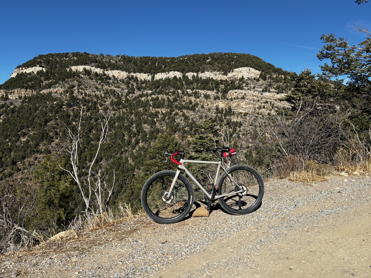
Next comes the turnoff for the Presbyterian Retreat Center, gated off. Then the trailhead for Palomas Peak, which I once hiked my loaded bike over for half a mile to bikepack at Lagunita Seca (Dry Meadow), a lovely forest opening at the base of Palomas Peak. Finally rounding one more switchback I stop at the first overview available looking back down Las Huertas canyon, allowing a far view across the Rio Grande valley all the way to the towering Jemez Mountains on the northwestern horizon. A bit farther ahead is another overlook, this time affording a view directly across a drainage to massive Palomas Peak, where I stop again.
The riding becomes easier after this, the road even levelling off for a bit. It was here a few years ago that I spooked a black bear as I rounded a corner; it took off in the opposite direction galloping at breakneck speed. A couple longer straightaways follow, then a few more switchbacks to the first views of the East Mountains around Sandia Park—the San Pedro and Ortiz ranges, and farther off the snow-capped rounded-off peaks of the Sangre de Cristo Mountains, where I make my last stop to take in the pleasing prospects and maybe snap a few photographs.
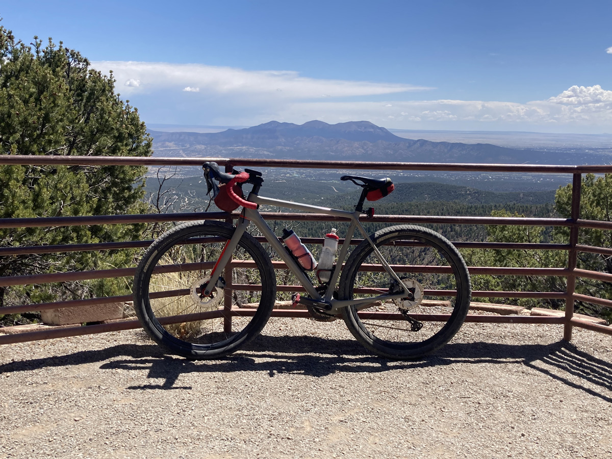
My goal at this time of year is to make it to Balsam Glade picnic area just off the Sandia Crest Highway at 8600’. It’s less than two miles away and the gradient is not too sharp on this stretch at 5-6%. Getting closer to the Crest Highway I can hear the occasional whine of a vehicle grinding up the road, maybe a jacked-up pickup or souped-up muscle car or motorcycle for which the ABQ area is (in)famous. Through a thick Douglas fir forest, I ascend on a long straightaway before one or two more switchbacks arise and—what a relief—smooth tarmac surfaces. I ride past a few motor tourists parked at the picnic area making a beeline for a short nature trail which winds around the bluff, dead-ending to some fine secluded views of more of the East Mountains. There I park my bike and take a well-deserved break on a bench. In the heat of summer there may be hawks soaring on the thermals coming off the mountain slopes.
I try hard not to focus on the graying “ghost forest” covering the slopes. Because of warming temps and drought conditions, beetles have made their way into the forests of the Southwest, killing off thousands of trees and creating ever-worsening wildfire conditions. Certain areas in the Sandias have been hit particularly hard. As an ex-fire lookout, I worry about the tragic consequences of a fire, natural or human-caused, getting out of control on a hot windy afternoon during one of these upcoming summers.
My mood grows brighter as I think of the reward for having climbed 3000’ from the hacienda: a fifteen-mile descent with only 1 short climb to get back to my starting point. Not that it will be a high-speed carom down the mountain; the rocks and ruts will keep me honest and cautious, at least until I reach pavement again for the last 5-6 miles back home. But with temps in the 60s even 70s at this high elevation, it will be a cool refreshing tonic to make my way back down the mountain.
Fall
From Balsam Glade picnic area at 8600’ it’s another five miles, 13 switchbacks, and 2000’ to the summit of the Sandias. Feeling ambitious in my favorite time of year I decide to Go For It. As Max Leonard writes in Higher Calling: Cycling’s Obsession with Mountains, “for road cyclists…there is nothing that improves a mountain view more than a nice bit of squiggly road going up it.”
60-70 degrees, bright sunshine, light winds—perfect riding conditions. The aspens are yellowing, the oaks are browning, and the doug fir and (farther up) the limber pines are as green as ever as I launch from Balsam Glade after a short refueling break. It’s early morning so the traffic on the Crest Highway is not yet bothersome. Grinding away in my lowest gears on the 8-10% gradients, I make slow progress but falling into a rhythm of deep breathing and steady cadence helps me endure the climb.
Now the suffering truly begins. The Spanish term duende comes to mind, loosely translated as “cruel beauty.” In Peter Cossins’s Climbers: How the Kings of the Mountains Conquered Cycling, he explains its nuanced meaning. Likening cycling in the mountains to the Spanish tradition of bullfighting, he explains the oxymoronic notion of appreciating the beauty of an endeavor while at the same time experiencing excruciating physical pain and maybe even risking serious injury or even death, all in the pursuit of personal achievement and glory. While citing bullfighting, mountaineering, and surfing as other sporting examples, he makes the case that “there is arguably no sporting activity where duende is more apparent than on the mountain stage of the world’s most prestigious and challenging road races. The setting is one of cruel beauty, the majesty of the scenery either heightened or compromised by the elements, the arena packed with fans to the extent that the riders are usually left with no more than a narrow, but fluctuating corridor of road to race on, the atmosphere loud, frenetic, unpredictable….”
Of course there are no fans on the roadside, frenetic or otherwise, as I continue to trundle up the Sandia Crest Highway—only the occasional sound of a passing vehicle, the call of some birds, and the whistle of wind through the treetops.
I ride past the Capulin Spring turnoff…past Ninemile Picnic Area…past the 10,000K parking lot…past the Ellis Trail lot…rounding the penultimate switchback and across the long straightaway I first glimpse the electronic towers on the summit of the Sandias…less than a mile to go! Then, in a last-gasp effort, I crawl up the steep climb through the parking lot past the restrooms and on to the walking trail to the very top…
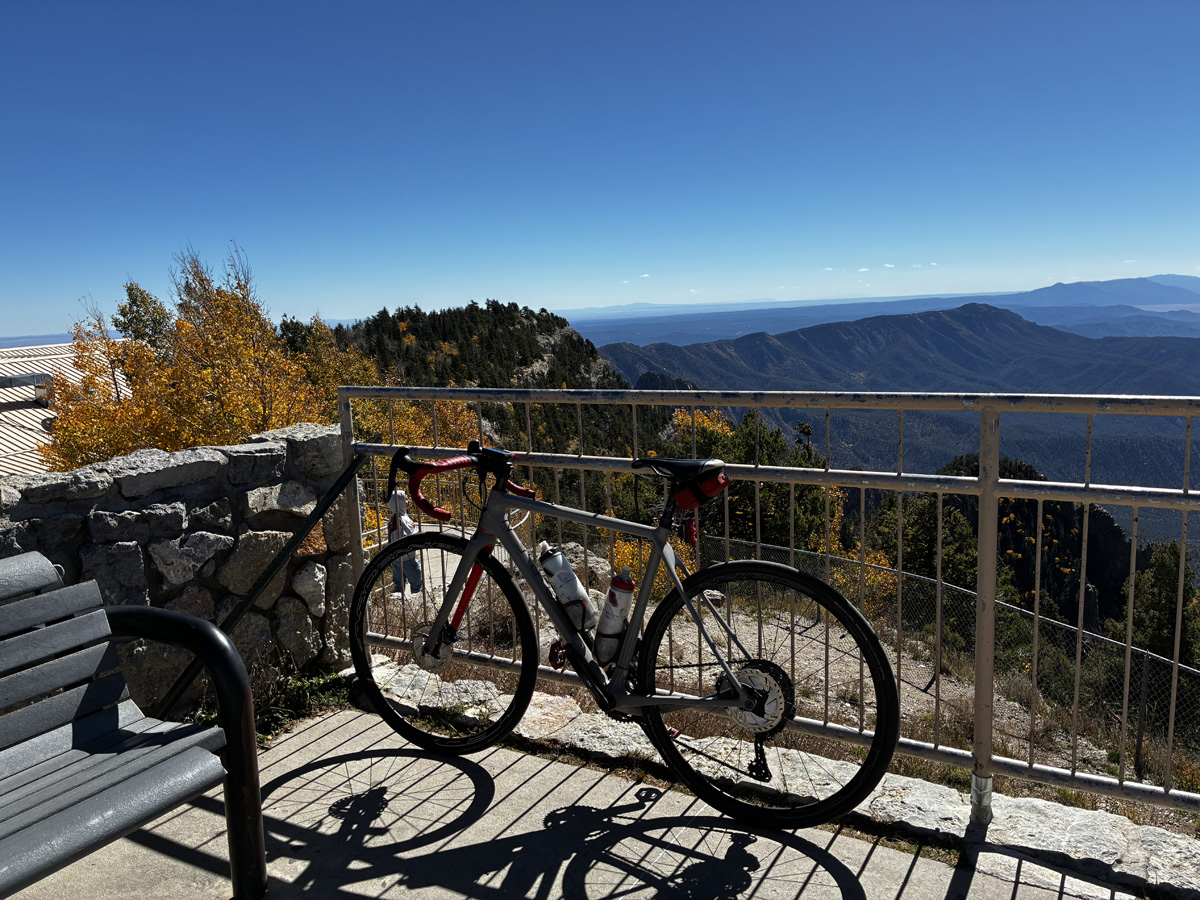
I’ve done it, summited the Sandias once again! A few tourists linger, taking selfies and making inane conversation. We ignore each other for the most part. Occasionally I’ll meet with a fellow cyclist and chat about the climb. This is not only the most iconic climb in the ABQ area but one of the hardest, longest ascents in the entire state. For some it’s a weekly ritual, for me it’s a twice-annual challenge.
To state the obvious, I’m no pro racer or Strava KOM achiever. Nonetheless as I wind my way up the switchbacks I can’t help but think of the peloton climbing up the iconic mountains of the Tour de France—the Tourmalet, the Alpe d’Huez, Col d’Izoard—and reliving a bit of the glory and feelings of triumph as I crest the summit.
The views are, as they sublime: to the west rises the old volcano of Mt. Taylor (one of the four sacred peaks of the Navajo); to the south the Manzano mountains; to the east the lower ranges of the San Pedro and San Ortiz; and to the north and northeast the Sangre de Cristo and Jemez mountains. Immediately below sprawls the metropolitan area of Albuquerque. When the air is clear I can see for more than fifty miles, all the way south to the Magdalenas, even the San Mateos. No better reward exists at the end of a cycling climb than far-off vistas, physical space commensurate with the internal feelings of personal accomplishments.
As always, there is nowhere to go but down. Physically, but not emotionally.


")


")