Red Bull Rampage Returns in 2021 and Celebrates 20-Year Anniversary
Southwest, Utah (June 29, 2021) – Red Bull is thrilled to announce the return of the premier big-mountain freeride event in the sport – Red Bull Rampage. Marking the 20-year anniversary of some of the biggest and baddest tricks, lines, and moments in freeriding history, 15 of the world’s best riders will descend upon the rugged desert landscape of Southern Utah on October 15, 2021 for the return of Red Bull Rampage.
A huge backflip in finals by this year’s second place finisher, Antoine Bizet. 2016 Red Bull Rampage. Photo by Photo John.
The inaugural Red Bull Rampage was held in 2001, and since then, 14 different events and 9 different winners have earmarked their place in the history books. For the 20th anniversary, get ready to celebrate as we not only look back at some of the best moments and stories from over the years, but also highlight the progression, tricks and technology that have shaped the contest throughout the years.
The competition format will remain the same, with an elite group of riders carving their ultimate lines into the side of near-vertical sandstone ridges with the help of their two-person build crews. In advance of the competition, riders and their support crew will spend four days building their lines, followed by a rest day, and then four practice days. All the preparation will end in an epic showdown in the desert, where only one will ride away as the champion of the 2021 Red Bull Rampage.
To stay up to date on the latest Red Bull Rampage information, including confirmation of the official rider list, venue details, Red Bull TV livestream tune-in times and potential spectator and ticketing info pending COVID guidelines from local/national authorities, follow @RedBullBike and read the following story here.
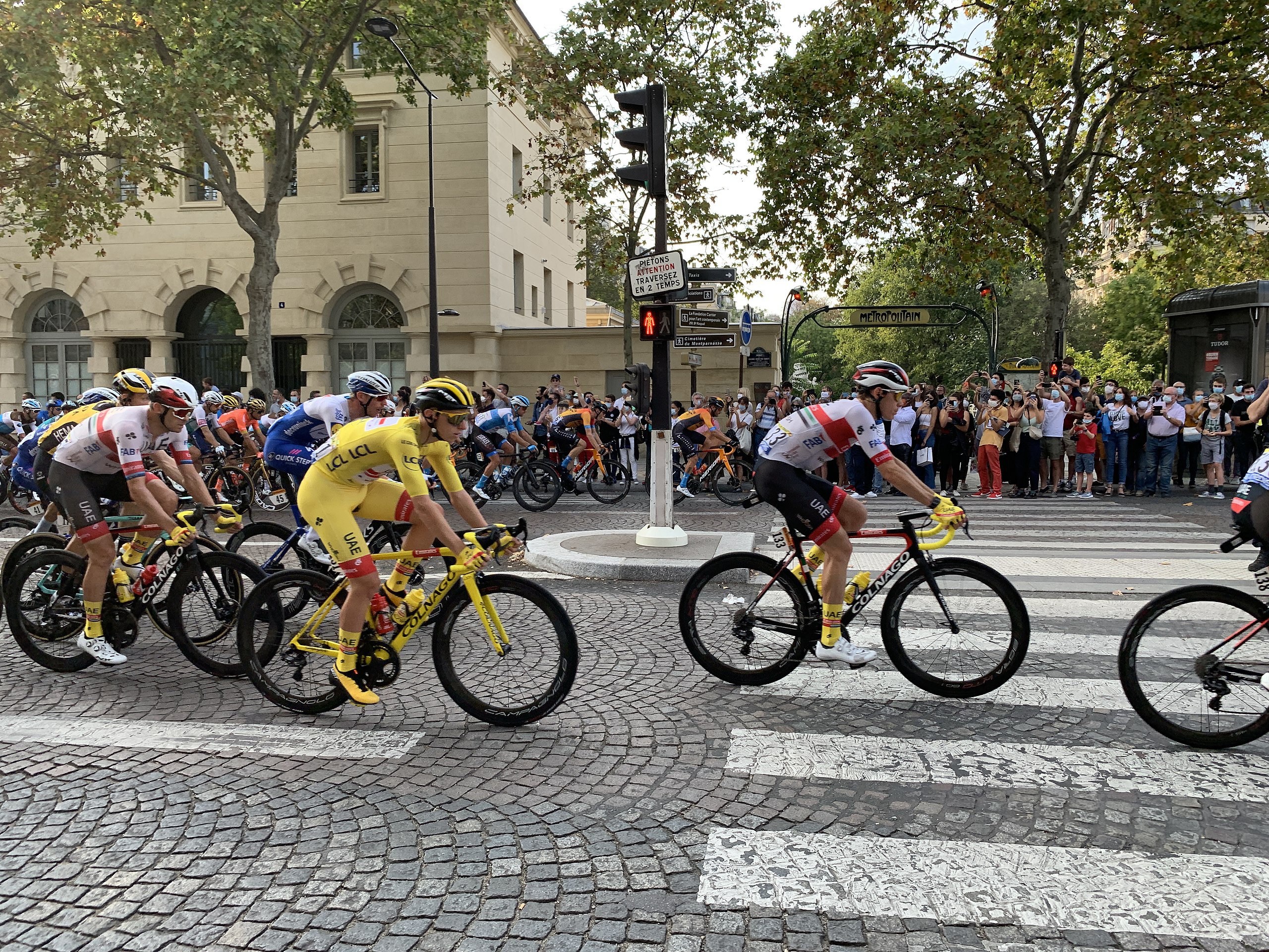
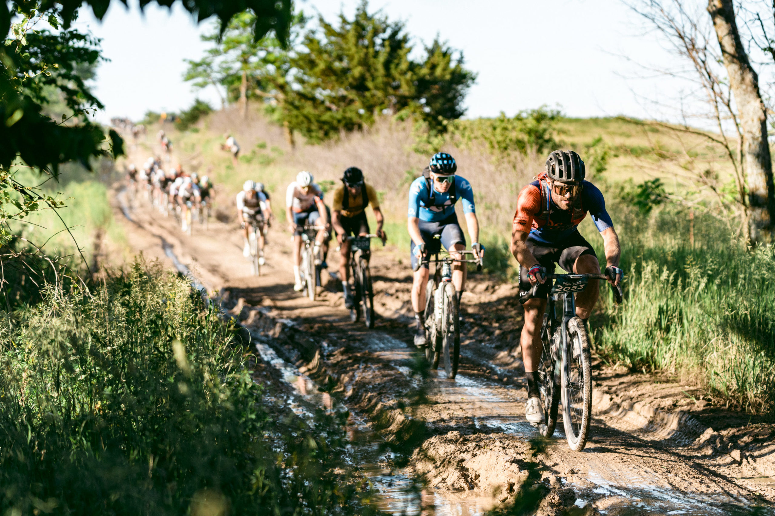
Imagine you begin pedaling from the start of Stage 17 of this year’s Tour de France. First, you would bike approximately 70 miles (112 km) with a gradual increase in elevation of around 1,300 feet (400 m). But you’ve yet to hit the fun part: the Hautes-Pyrénées mountains. Over the next 40 miles (64 km) you would have to climb three mountain peaks with a net increase of a mile (1.6 km) in elevation. On the fittest day of my life, I might not even be able to finish Stage 17 – much less do it in anything remotely close to the five hours or so the winner will take to finish the ride. And Stage 17 is just one of 21 stages that must be completed in the 23 days of the tour.
21e étape du Tour de France 2020, avenue du Colonel Henry Rol Tanguy, Paris. Winner Tadej Pogačar in yellow jersey and on a yellow bike, 2020-09-20 in France. CC BY-SA 4.0
I am a sports physicist, and I’ve modeled the Tour de France for nearly two decades using terrain data – like what I described for Stage 17 – and the laws of physics. But I still cannot fathom the physical capabilities needed to complete the world’s most famous bike race. Only an elite few humans are capable of completing a Tour de France stage in a time that’s measured in hours instead of days. The reason they’re able to do what the rest of us can only dream of is that these athletes can produce enormous amounts of power. Power is the rate at which cyclists burn energy and the energy they burn comes from the food they eat. And over the course of the Tour de France, the winning cyclist will burn the equivalent of roughly 210 Big Macs.
Cycling is a game of watts
To make a bicycle move, a Tour de France rider transfers energy from his muscles, through the bicycle and to the wheels that push back on the ground. The faster a rider can put out energy, the greater the power. This rate of energy transfer is often measured in watts. Tour de France cyclists are capable of generating enormous amounts of power for incredibly long periods of time compared to most people.
But not all of the energy a Tour de France cyclist puts into his bike gets turned into forward motion. Cyclists battle air resistance and frictional losses between their wheels and the road. They get help from gravity on downhills but they have to fight gravity while climbing.
I incorporate all of the physics associated with cyclist power output as well as the effects of gravity, air resistance and friction into my model. Using all that, I estimate that a typical Tour de France winner needs to put out an average of about 325 watts over the roughly 80 hours of the race. Recall that most recreational cyclists would be happy if they could produce 300 watts for just 20 minutes!
Turning food into miles
So where do these cyclists get all this energy from? Food, of course!
But your muscles, like any machine, can’t convert 100% of food energy directly into energy output – muscles can be anywhere between 2% efficient when used for activities like swimming and 40% efficient in the heart. In my model, I use an average efficiency of 20%. Knowing this efficiency as well as the energy output needed to win the Tour de France, I can then estimate how much food the winning cyclist needs.
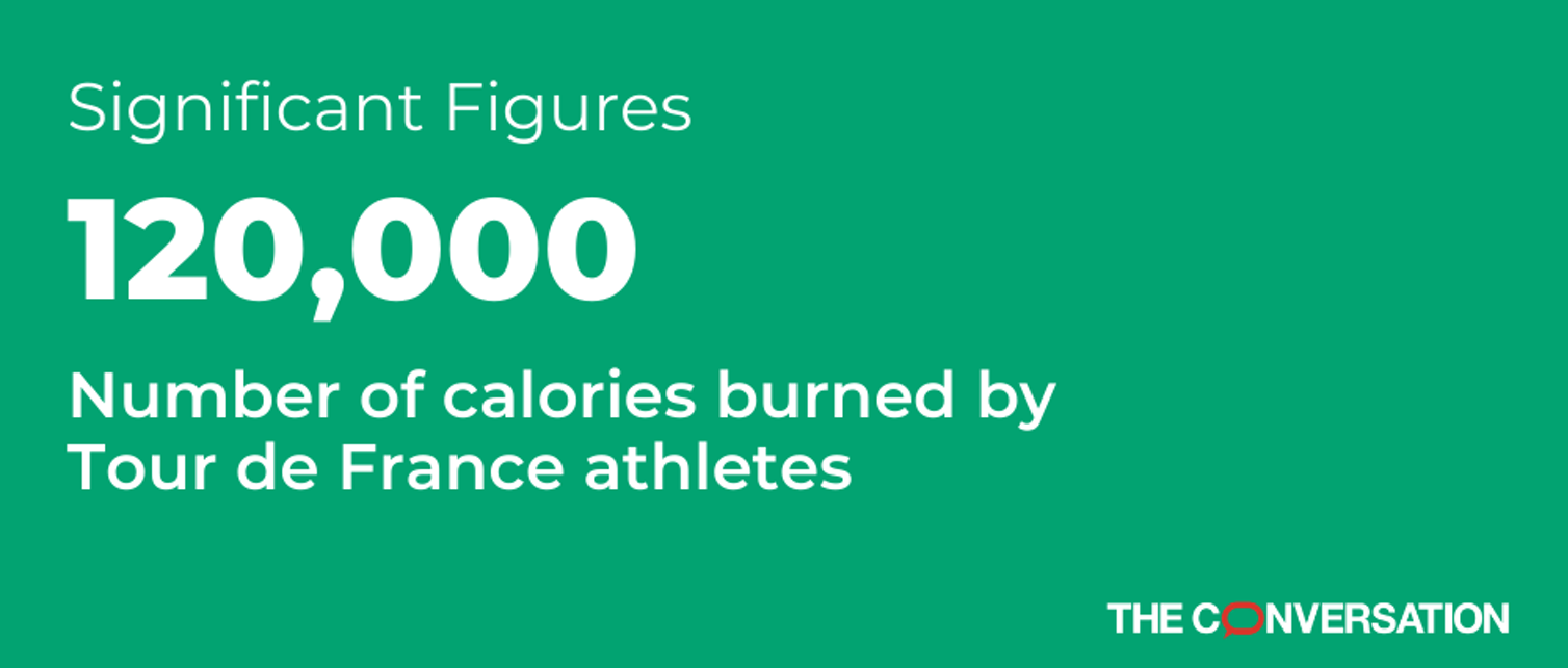
Top Tour de France cyclists who complete all 21 stages burn about 120,000 calories during the race – or an average of nearly 6,000 calories per stage. On some of the more difficult mountain stages – like this year’s Stage 17 – racers will burn close to 8,000 calories. To make up for these huge energy losses, riders eat delectable treats such as jam rolls, energy bars and mouthwatering “jels” so they don’t waste energy chewing.
Last year’s winner, Tadej Pogačar, weighs only 146 pounds. Tour de France cyclists don’t have much fat to burn for energy. They have to keep putting food energy into their bodies so they can put out energy at what seems like a superhuman rate. So this year, while watching a stage of the Tour de France, note how many times the cyclists eat – now you know the reason for all that snacking.
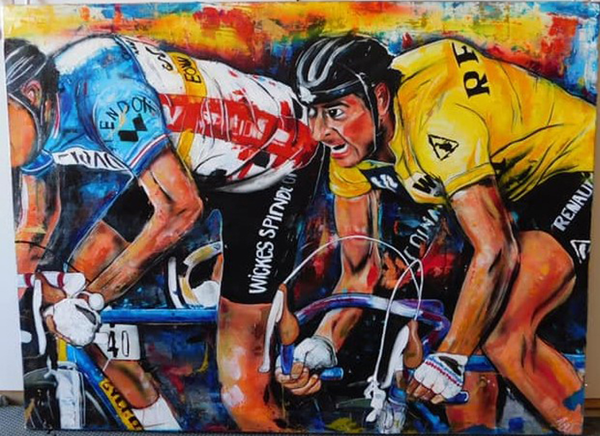
Artist’s Statement: I loved doing this piece , it was a commissioned piece. I wanted to capture the energy and excitement felt by the riders.
Artist: TJ Eisenhart, Title: Final Sprint, Size: 48X60, Medium: Oil, acrylic, airbrush on canvas
Artist: TJ Eisenhart
Title: Final Sprint
Size: 48X60
Medium: Oil, acrylic, airbrush on canvas
Note: The painting is of the Tour de France 1981 stage12b;
A classic, determined, three-up sprint between Eddy Planckaert, Guido van Calster, and the legendary Bernard Hinault.
To view more of TJ’s art follow him: @tjeisenhart on Instagram. You can also view some of his work at DuVin Pintor Gallery located in Trolley Square, Salt Lake City, Utah.
If you are interested in a commissioned piece, contact him at [email protected].
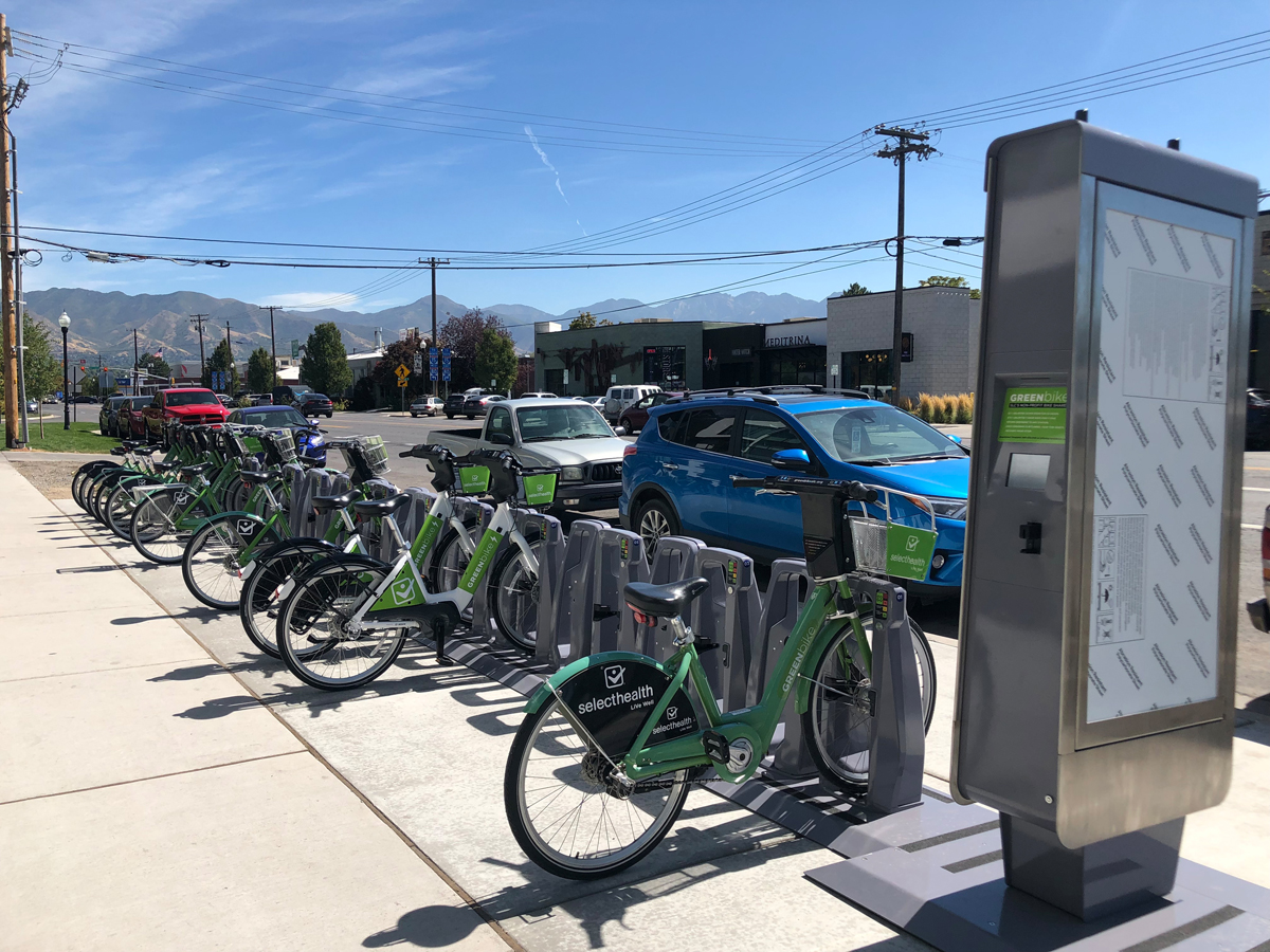
SALT LAKE CITY, Utah (June 23, 2021) — GREENbike, Salt Lake City’s non-profit bike share system, and the nonprofit’s title sponsor, SelectHealth, are offering free GREENbike rides to the public on Saturday, June 26. On Saturday, all Salt Lake City residents and visitors will be able to ride GREENbikes for free during the 24-hour period by using the promo code “2021” at any of GREENbike’s 47 stations. After using the code, riders can take as many 30-minute trips as they want during the 24-hour window.
Greenbike, Salt Lake City’s bike share, expanded 300% recently including this new station in the Central 9th area. Photo by Dave Iltis
“SelectHealth is invested in our community. Supporting air quality, recreating, and getting around town are some of the benefits of riding GREENbikes. Enjoy a free ride day powered by SelectHealth,” said SelectHealth Sr. Public Relations Manager Greg Reid. “GREENbike supports our mission of helping people live the healthiest lives possible.” Over the past eight years, GREENbike riders have offset more than 5.97 million pounds of CO2 from entering the air and prevented more than 6.58 million vehicle miles from impacting local roads. GREENbikers burned nearly 80.7 million calories—roughly 283,248 slices of pizza—in the process. The local non-profit bike share system is dedicated to offering the community an affordable, convenient, and sustainable transportation option. “Thanks to SelectHealth’s generosity anyone interested in taking a GREENbike for a spin this Saturday can do so for free,” said GREENbike Executive Director & Founder Ben Bolte. “Whether you’re a frequent rider or haven’t tried a GREENbike yet, we hope this will give folks a good excuse to get out and enjoy a free bike ride this weekend.” To find a GREENbike station, download the BCycle app or go to https://slcbikeshare.org/station-map.
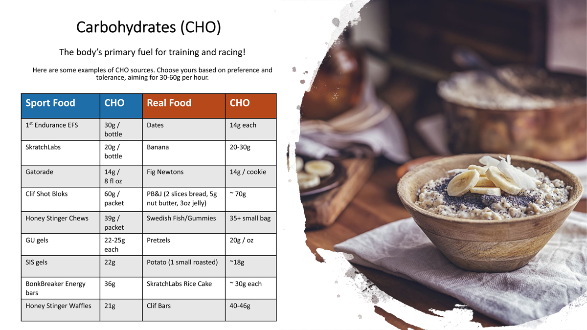
If you’ve read any of the articles I’ve written in the past, you’ll know that I often compare our bodies to engines. This is definitely the case with the principal source of fuel for our engines: carbs. As endurance athletes, you likely know that carbohydrates are the primary source of energy that our muscles use to work. So, it may seem too simple to state, but it is essential that we intake the appropriate amount and type of carbohydrates for optimal performance.
Let’s start with the math. The rule of thumb is to intake 30-60g of carbohydrate per hour for endurance exercise. That’s 120-240 calories coming from carbs. Depending on your size, gender, fitness level etc., you may need more or less, but consider those ranges your minimum needs. The higher the intensity and longer the duration of your ride, the more fuel you need. Makes so much sense, right?! Granted there may be some fat or a tiny pit of protein in the fuel you choose, which will add to the total calorie intake, but please remember that carbs are the energy source that make your muscles (and brain) go!
Now for the type of carbohydrates to intake. For everyday nutrition we talk about complex carbohydrates (whole grains, legumes, starchy vegetables), though around exercise we want simple carbohydrates (sport drinks, chews, gels, etc.). We want to take in calories via simple carb sources because they are easy to digest, absorbed directly into the bloodstream rather than having to go through the stomach, giving immediate energy to working muscles. The chart I’ve created here is a list of sport food and traditional, fresh food to give you ideas.
Of course, there are a multitude of options out there, the trick is finding what’s right for you and your body. The goal is to match the numbers to the intensity and duration of your ride. It may take some trial-and-error with various foods, drinks, and/or gels. Over time, you’ll learn what works best for you, and then it becomes a matter of habit. Remember to fuel your engine for training as you would for an event, so that you teach your body to always utilize the carbs!
If you need any guidance in determining your exact calorie and carbohydrate needs, please contact me. In my next few articles, I will focus on healing before and recovery from training and racing.
By Charles Pekow — Once again, Senator Mike Lee (R-UT) is trying to let those in the neighborhood decide which currently designated wilderness areas people can ride their bikes. He reintroduced the Human-Powered Travel in Wilderness Areas Act (S. 1686), which would amend the Wilderness Act of 1964 to allow local federal officials to determine the manner in which non-motorized uses may be permitted in wilderness areas. The bill was referred to the Committee on Energy and Natural Resources.
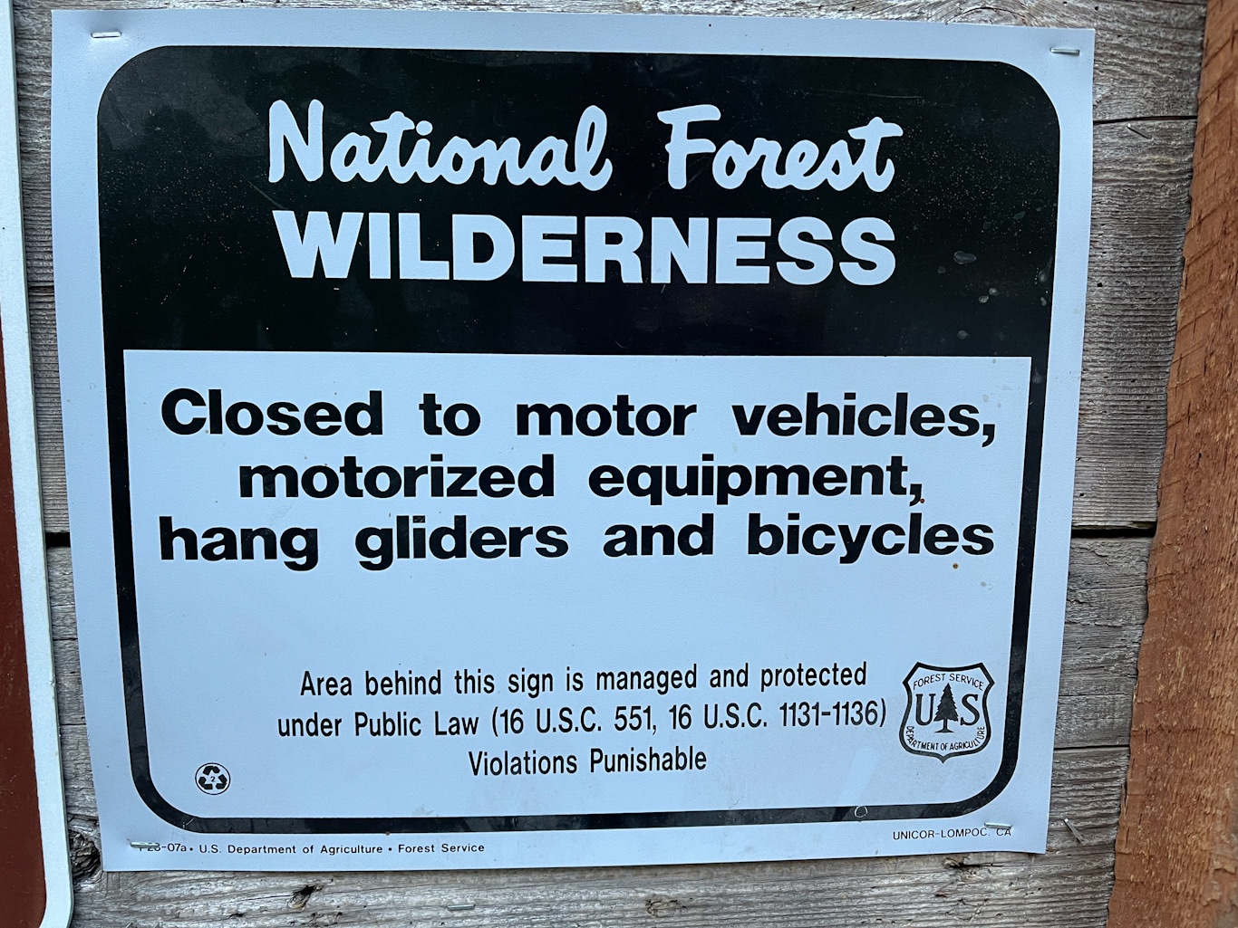
Bicycles are not allowed in Wilderness since they are classified as mechanized transport. Photo by Dave Iltis
The Interior Department has interpreted the law to ban mountain biking in federally designated wilderness. Lee’s act would not affect the ban on motorized transport.
The bill picked up no initial cosponsors. Lee has introduced the bill in the previous three congresses, but it never got out of committee, though it became the topic of a subcommittee hearing last November.
“The National Wilderness Preservation System was created so that the American people could enjoy our country’s priceless natural areas,” Sen. Lee said in a prepared statement. “This bill would enrich Americans’ enjoyment of the outdoors by expanding recreational opportunities in wilderness areas.”
“Sen. Lee is using the mountain bike community to poke the environmental community in the eye and sew discord between us and the environmental groups,” charges Ashley Korenblat, owner of Western Spirit Cycling in Moab, UT, a mountain bike trip organizer. “Further, this bill will never open one inch of trail. It will be litigated instantly and if any land manager actually tried (to open land), the land manager will be sued.”
“We have something like 100,000 miles of ready to ride trials” in the country with more on the way and less than 1,200 miles would be affected by the law. “We don’t need those miles.”
Korenblat notes that while mountain biking is increasing, “the environmental community right now is growing much faster than the mountain biking community is growing. At a time of climate change, do you really want to attack the founding legislation of the modern environmental movement? Is that where we want to put ourselves in the cycling community?”
By Tom Jow — The summer solstice is past and riding season is in full swing. For me however, it seems like I am just getting started. What this means is that in addition to trying to find time to ride, I must also find time to get the family bikes ready to go. Don’t get me wrong, I put them away clean and tuned. But after a winter’s worth of hanging around in the garage, there are some important details that need to be taken care of before departing on that first ride. Taking care of these details is much easier if there is some record of them.
Obviously one of the first things to do is inflate the tires to the proper pressure. If you’re using tubes then yes, inflation is step one. If your bike uses tubeless tires, it’s a good idea to check the condition and amount of the sealant inside the tire first. In our climate, the liquid tubeless sealant needs to be refreshed about every six weeks. True, the tires will hold air longer than that, but having dry sealant greatly reduces puncture sealing ability.
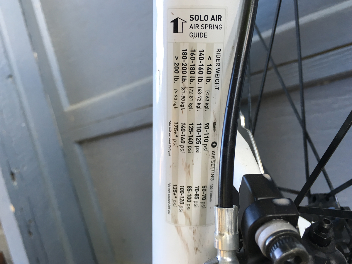
Next, what is the proper tire pressure? The manufacturer provides a range on the side of the tire. Charts referencing tire size and rider weight can be found on the internet. These are great for initial setup. However, every rider has their own preference. Tire size and rim width also have a significant effect on tire pressure choices. I will refrain from making any recommendations other than I find that as the tire volume goes up, the tire pressure can be reduced. When you find the sweet spot, I highly recommend writing it down.
Check the pressure chart or shock manual or website. Photo by Tom Jow
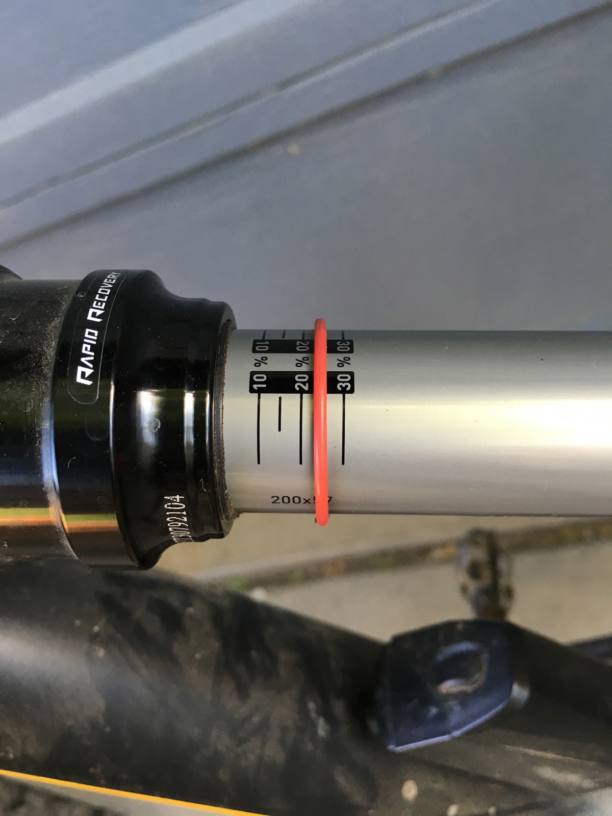
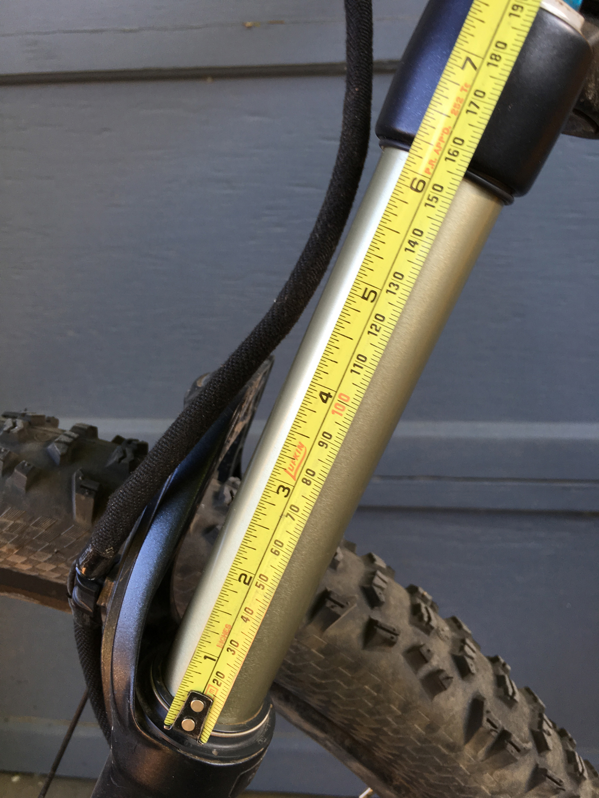
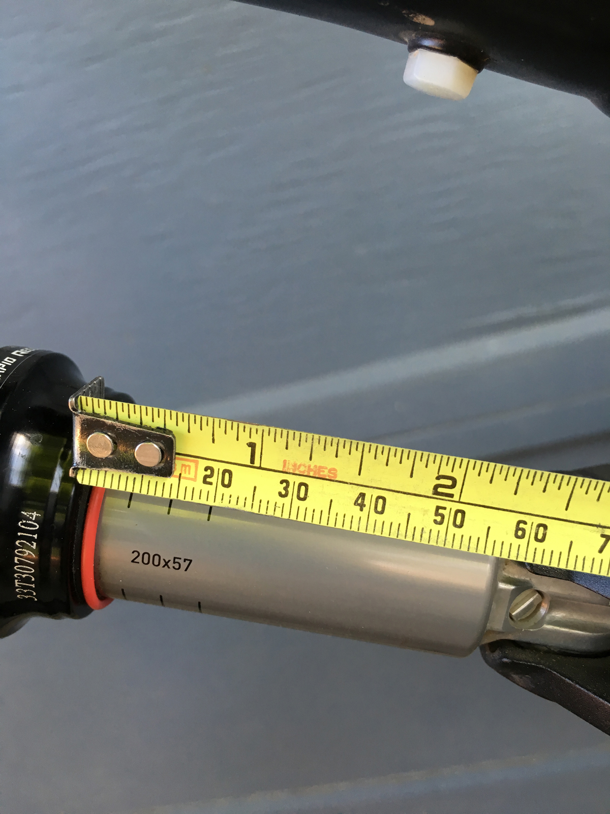
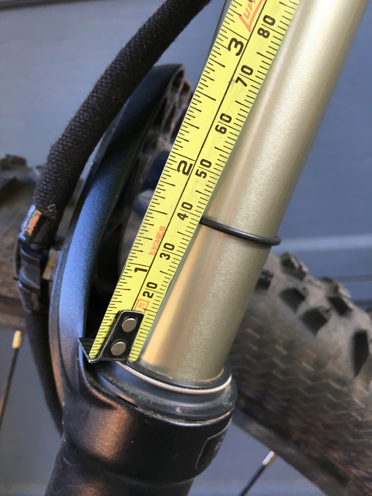
Another adjustment to keep track of is the suspension air pressure. There are two ways to find the initial pressure. One way is the manufacturer recommendation. One brand has it on a sticker right on the fork leg. Others have it buried in a manual, usually on a web page somewhere. Another way is to test the sag of the fork or shock travel. To measure the suspension sag, it is required to know the travel of the fork or shock and the recommended amount of sag in percent. As the amount of travel goes up, usually the sag amount does as well.
Note how much sag you have. See the article for details on how to test sag. Photo by Tom Jow
In order to measure the suspension fork travel, first measure the length of the fork from the top of the seal to crown. That will approximately equal the fork travel. Apply the percentage of sag to the suspension travel to come up with a measurement. For example, if a fork has 150mm of travel, 30 percent sag would equal approximately 50mm. This means that the initial air pressure setting would allow the fork to compress 50mm under the rider’s weight. In this example, adjust the pressure until the distance from the seal to crown is, for this example, 100mm. Record this air pressure. Setting the rear shock can be done in a similar fashion by measuring to the end of the shock shaft. Record this air pressure also. If the fork or shock has an o-ring on the slider, weight the bicycle, slide the o-ring to the seal, and then gently dismount the bike. When properly set, there would be (using our previous example) 50 mm between the seal and the o-ring.
To keep track of suspension pressure, first measure the fork. Photo by Tom JowMeasure the rear shock. Photo by Tom JowNext, measure the sag. Photo by Tom Jow
Finally it’s time to ride. Pay close attention to the way the bike rides with these settings. I often carry a shock pump with me in order to make adjustments during the ride. Sometimes it takes three or four rides to find the pressure you like. When you have found it, write it down.
Did this procedure take a while? Depends on how many bikes. Did you write everything down? I hope so. Because if you did, it’s going to save you preparation time for every ride. Perhaps more importantly, it will save time when it matters most; for that first ride of the season when all the family bikes need to get dialed in.
Cycling West and Cycling Utah Magazine’s Early Summer 2021 Issue is now available as a free download (12 MB download). Pick up a copy at your favorite Utah, Idaho, Wyoming, Nevada, Montana, Colorado, Arizona, New Mexico and Northern California bike shop or other location.
By Brandi Williams — Summer is just around the corner. Cyclists everywhere are chomping at the bit to get out on their bikes! This year in particular, after a year of lockdowns, the call of the open space that biking provides, is irresistible. No Peloton can substitute for that feeling of being out in the middle of nowhere, alone on your bike or with your best pal, with a breath-taking view of the wilderness. Whether you are out on a remote mountain trail, riding a road in the back country or just tooling around town, an early spring ride boosts the spirit!
And yet, we can’t help but notice that things have changed. In many places, unusually warm and dry weather has allowed cyclists to ride throughout the winter. In other places like Texas, the polar vortex put a halt to any thoughts of a bike ride. Instead citizens huddled under blankets for warmth, awaiting the return of electricity. Needless to say, the effects of a changing climate are altering the way we participate in the sport we love. Here in the Mountain West, hotter summer days make it unbearable to go for an after-work ride until the sun has nearly set. Or worse yet, the wildfires in drought-ravaged forests have destroyed our favorite trails or filled the air with smoke too unhealthy to breathe. Witnessing these changes can make us feel helpless. It can make us worry our children won’t be able to enjoy the simplicity of a bike ride through the mountains.
But we are not helpless. There are solutions and we as individuals, as well as the biking industry, can help bring those solutions to fruition. The decisions we make right now will determine that future. The $6 billion cycling industry is booming and has been a consistent driver of economic growth, even during the pandemic. The success and influence of the biking industry has never been greater. With many conservation-minded individuals, the biking industry is poised to be a leader in the efforts to promote climate solutions.
One popular solution is the Energy Innovation and Carbon Dividend Act (http://EnergyInnovationAct.org). This bill would place a fee on fossil fuels at their source based on the amount of CO2 that they emit when burned. As the fee increases annually, it creates market-based incentives for businesses and households to reduce their carbon footprints. The money that is collected would be shared equally by all Americans as a dividend, offsetting the higher cost of energy and in many cases, putting extra money into the pockets of consumers. This money could be used for anything they see fit including recreational activities such as biking. This legislation has the potential to reduce carbon emissions 40% in just 12 years and 90% by 2050! A safe and healthy climate could give the biking industry a boost, as many people would decide to use biking as an alternative form of transportation.
Now is the time for the biking industry to help shift the gears of our climate. Ask your local bike shop to sign the Biking Industry’s Climate Declaration (https://www.businessclimateleaders.org/bikingindustrydeclaration) which is a statement that acknowledges the need to address the climate crisis and supports the Energy Innovation and Carbon Dividend Act as a possible solution. Tell your member[s] of Congress that you want action on climate legislation and that you support the market-based Energy Innovation Act. It is said that you have to envision the future you want before you can make it happen. Let’s envision a future where the air is healthy, the climate is stable, the birds are chirping in the forests and we can all get on our bikes any time of day and go for a ride!
Brandi Williams is co-leader of the Salt Lake City chapter of Citizens’ Climate Lobby, a grassroots organization dedicated to creating the political will for enactment of federal legislation on climate change.
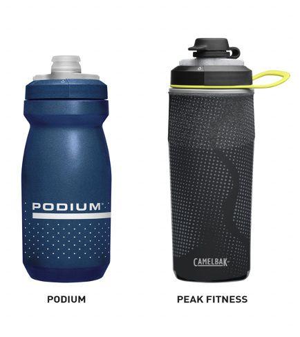
CamelBak Recalls Caps Sold with Podium and Peak Fitness Water Bottles Due to Choking Hazard
Recall Date: June 9, 2021
Recall Number: 21-149
Recall Summary
Name of product: CamelBak Podium and Peak Fitness water bottles
Hazard: A small silicone valve in caps sold with the Podium and Peak Fitness water bottle can come loose and detach, posing a choking hazard.
Remedy: Replace
Consumers should immediately stop using the recalled caps sold with the water bottles and contact CamelBak for a free replacement cap.
Consumer Contact: CamelBak at 800-767-8725 from 8:30 a.m. to 5p.m. PT Monday through Friday or online at www.camelbak.com/recall or www.camelbak.com and click on “Recall Information” for more information.
Recalled certain caps sold with CamelBak’s Podium and Peak Fitness water bottlesDate code can be found on the underside of the cap.
Recall Details
Units: About 46,000 (In addition, about 13,000 were sold in Canada)
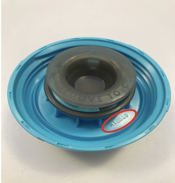
Description: This recall involves certain caps sold with CamelBak’s Podium and Peak Fitness water bottles with three date codes. The date codes are H19039, H19063 and H19175 and are located on the underside of the cap. The water bottles were sold in a variety of colors in 17, 21- and 24-ounce sizes. CamelBak and Podium or Peak Fitness are written on the bottles.
Incidents/Injuries: CamelBak has received 14 reports of the silicone valve coming loose in the cap and detaching. No injuries have been reported.
Sold At: Sporting goods stores nationwide and online at camelbak.com from February 2019 through January 2021 for between $10 and $25 depending on the bottle.
Importer(s): CamelBak Products LLC, of Petaluma, Calif.
By Kelly McPherson — Riding with a group is one of the best things you can do for your cycling. You can learn everything from where to find the best deals on gear, to what that thingy in the end of your handlebar is called, to how to ride in a group, where the best routes are and how to push yourself harder for longer. Riding in a group regularly is extremely useful, but finding that perfect group to ride with can be somewhat elusive.
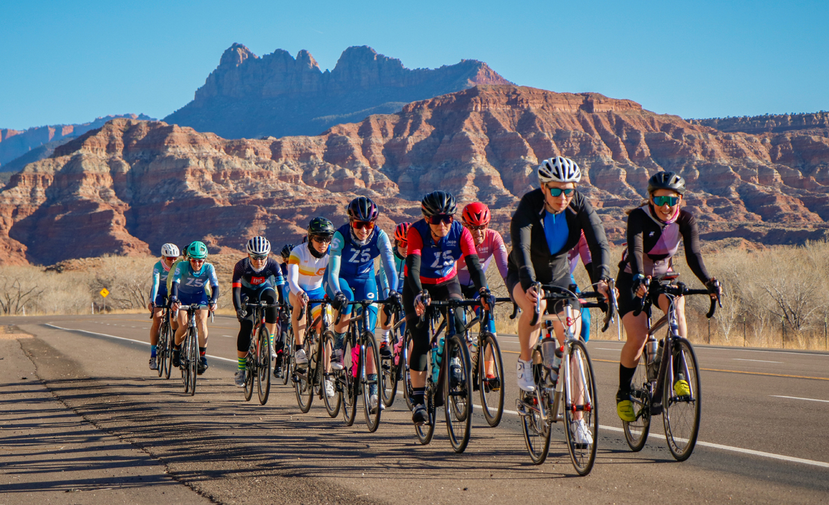
The Zone 5 women on a group ride. Photo by Paul Biesinger
Step one would probably be to join a local club of similarly bike minded riders. Below are some links to get you started. Also check with your local bike shop or fitness center. Oftentimes they have groups that ride.
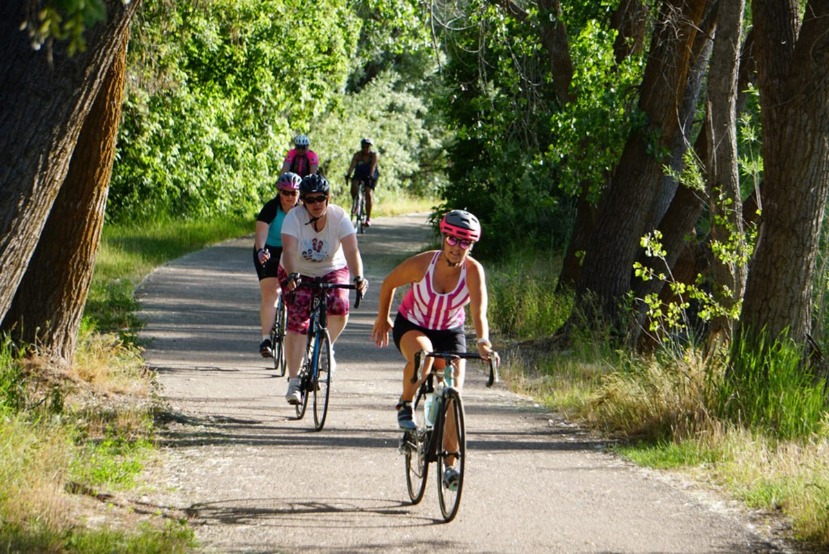
On a group ride with Wildflower Outdoor. Photo courtesy Wildflower Outdoor.
Even if you have joined a club or a team, there is no guarantees that the group will be filled with people the same ability level as you. As a slower rider, I have been on many group rides. Some of them good. Some of them not. Below are some tips for facilitating group rides that include slower riders.
Make expectations for the ride clear. Is this a drop ride? Will you be grouping up regularly? Will there be a lot of climbing? What is the average pace of the riders involved and how far and long will be planning on riding? I once joined a ride well above my skill level and got dropped within the first 30 seconds. Those riders went so fast that I don’t think that their wheels even touched the ground. Had I understood ahead of time, I might not have made the extra effort to drive across town to join them.
If you post it as a ‘no-drop’ ride, it had better be a ‘no-drop’ ride. Don’t leave people in the dust unless it has been agreed upon beforehand that might happen. Agree ahead of time whether you are waiting at the top of climbs and at the other side of stop-lights. How long will you wait?
Make sure everyone knows the route. There is nothing worse than getting dropped from a ride and having no idea where you are, where to find water and how to get back to where you started. If possible post a map that people can download onto their phones. Make sure to get peoples cell phone numbers so you can communicate unavoidable changes in plans.
Tell us, nicely, when we are doing something stupid or dangerous. We don’t know until you tell us. We are usually keenly aware of the fact that we aren’t as good as you, but we don’t always know why. Please kindly educate us. None of us want to be “that girl/guy” that no one wants to ride with because they are dangerous.
Talk to us. Get to know us. Include us in your conversations. We may not be able to contribute very much. Your conversational pace may be our threshold pace. We aren’t trying to be rude, we are just doing everything we can to stay with the group and not kill anyone. What comes naturally for you, may take a lot of concentration for us.
Make sure we are included in pictures too. We want to post the cool pics on social media just as much as the next person, but if we can’t keep up, it makes it tough to be where the pictures are being taken to be in them. If you aren’t going to wait for slower riders at the turn around points, consider taking and posting pictures at the starting point when everyone is together. I recently rode with a massive group and got to the picture taking point just a minute after it was taken and the group was breaking up. Just because we are slow, doesn’t mean that we don’t want the memories.
Ride with us on your recovery days. You know, those days when you don’t want to ride with your regular group because you know it will get too spicy to count as a recovery day? Those are perfect to ride with slower riders. You get the recovery you need and we get your company. We would love it! Let the slower riders set the pace on this one. Just don’t make too big of a deal that it is your recovery day. We have egos too!
Below are some tips for slower riders who are wanting to ride with faster, more experienced riders.
Join the ride. You won’t get to be a better group rider unless you actually join a group. It takes bravery to join a group of people you may not know, but it is so worth it.
Respect the ride parameters. If a fast, drop ride that is way above your ability level, don’t demand that other cyclist wait for you or accommodate you. I would find a different ride to jump in on. You will only frustrate people. You can start with them and let them know that they have no need to wait for you, but oftentimes cyclists may feel guilty dropping you anyway. Avoid doing that.
Know where you are going. Ask! If you don’t know, you need to ask and find out. Make sure Google Maps is working on your phone in case you get lost.
Be prepared. You may get dropped. You may spend a lot of time riding by yourself. Make sure you have enough repair supplies, food, water, cash and cell phone to get you safely home again. Know how to change a tire and make basic repairs. Don’t depend on others to take care of these things for you.
Communicate your needs. If you want them to wait at certain points or if you are going to flip when you see them flying back down a big climb, let them know. If you would like company on the climb or want to climb alone, let people know. Do not just leave a ride and go home without telling anyone. This means you may need to get cell phone numbers so you can tell them. It is not fun to be waiting for a slower rider at the top of a climb only to find out that they flipped ages ago and went home without telling anyone.
Be gracious about advice. Listen to the more experienced riders when they let you know that you should change something about the way you are riding. When riding in a group, everyone’s lives are in each other’s hands. They are trying to make sure everyone makes it back in one piece. If it is advice about nutrition, training, gear, etc., make sure to listen and ask questions and then make your own decisions about what is good for you. No two riders are alike.
Have fun! Don’t be so concerned about being the slowest or least experienced rider that you forget to have fun and come back to the next group ride. It will get better. It will get easier. Though, likely, you will spend quite a bit of time riding on your own in the meantime. Don’t get frustrated. Look up and enjoy the places your healthy body and two wheels take you.
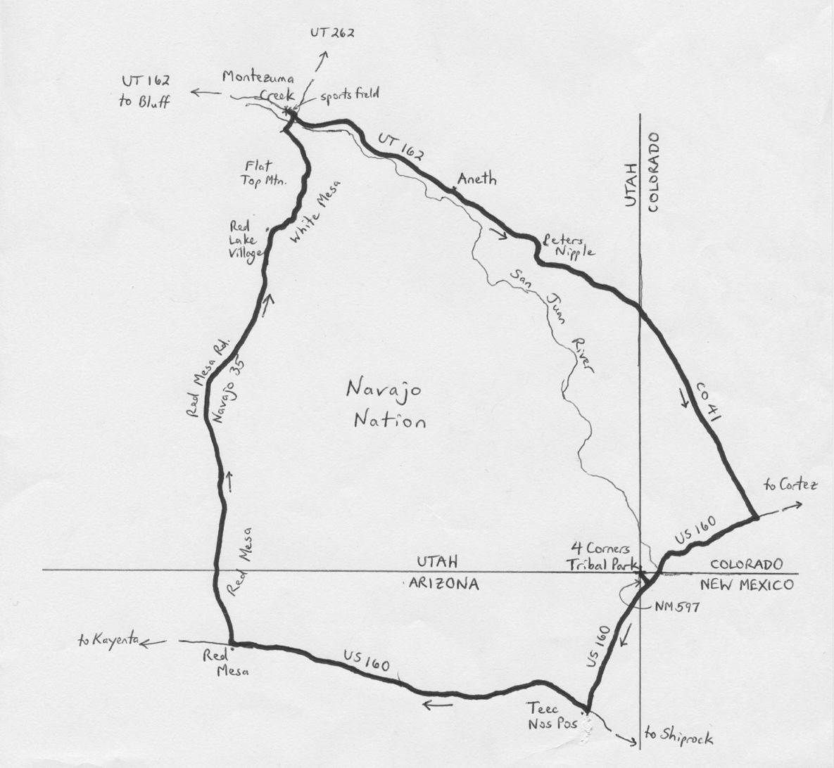
By Wayne Cottrell — Four Corners Circle is a 77.2-mile clockwise road loop in extreme southeastern Utah. But, as the title suggests, the road ventures briefly into three other States: Colorado, New Mexico & Arizona. This is the only spot in the U.S. where one can visit four different States in one reasonably short trip. Most of the ride is effectively within the boundaries of the Navajo Nation. In fact, the Four Corners Monument, which the ride visits, is a Navajo Tribal Park. The terrain is rolling, with no major climbs or descents. The elevation range is about 1,000 feet, though, from 4,423 feet in Montezuma Creek to 5,364 feet in Red Mesa. The Navajo Nation occupies 27,425 square miles in a region that spans northeastern Arizona, southeastern Utah, and northwestern New Mexico. Although the Nation was established by the Treaty of 1868, the Utah portion was not fully appended until 1933, some 28 years after President Theodore Roosevelt had officially approved of the additional lands. The Navajo Nation is home to about 175,000 Native-Americans, and is semi-autonomous, in that the U.S. retains power over all executive decisions. While tourism has boosted the economy, oil fields have been the Nation’s primary economic engine (and, earlier, uranium mining).
4 Corners Circle Bike Route Map. Map by Wayne Cottrell
Start the ride in the community of Montezuma Creek, located on Utah State Highway (UT) 162. Montezuma Creek had a population of just over 500 in 2000 (more recent data are not available), and is located 14 miles east of Bluff. The closest major city is Albuquerque, New Mexico, 270 miles to the southeast. Salt Lake City, Utah and Phoenix, Arizona are each equidistant, at 345 miles away. From Montezuma Creek’s sport fields and swimming pool (closed), located on Trading Post Road (UT 162), head east on UT 162. Note that the resident populations of the communities through which the route passes are at least 95% Native-American, so be prepared for immersion in local culture. At Center Street, turn right, followed by a left onto Main Street, to continue heading east on UT 162. The San Juan River and adjacent bluffs are a constant presence, to your right. The next settlement, Aneth (population 600 in 2000), is considered to be a Navajo Nation gateway community. Aneth was first settled by non-Mormon whites, however, in the late 1870s, who would later move away after several years of crop failures.
The San Juan River veers away from the highway as you head eastward from Aneth. Peters Nipple is on the left as you cross Rockwell Flat. Enter Colorado at mile 17.4; you are now on Colorado State Highway (CO) 41. The State line also marks the boundary of the Navajo Nation, as you enter the Ute Mountain Ute reservation. While the latter covers a sizeable region in southwestern Colorado and northeastern New Mexico, its population is dwarfed by that of the Navajo Nation, which has about 100 times as many residents. CO 41 ends at U.S. Highway 160, at mile 26.7; turn right here and head southwest. After crossing the San Juan River, US 160 enters New Mexico for a short stretch. Look for New Mexico State Highway (NM) 597 at mile 33.3. Signs indicate that this is the way to Four Corners. This is a short out-and-back segment, just 0.9 miles total, which is well worth the diversion. Enter Four Corners Navajo Tribal Park at the end of the highway; there is a nominal fee to access Four Corners Monument. Four Corners is at an elevation of exactly 5,000 feet. The requisite action is to stand on the monument, and take a selfie with at least one part of you or your bicycle in each of the four States! Although many visitors are “underwhelmed” by the experience, the monument’s inscription, having to do with four States “meeting in freedom,” is actually quite inspiring.
Exit Four Corners on NM 597, and then turn right to continue heading southwest on US 160. Enter Arizona – note that the Navajo Nation observes daylight savings time, unlike the rest of Arizona. The highway turns right at mile 40.0, in the town of Teec Nos Pos (elevation 5,210 feet). The town’s name means “cottonwoods in a circle,” as opposed to anything else, and is the largest settlement along the route (population 730 in 2010). As this is approximately the midpoint of the ride, this may be a fine place to refresh and replenish. Continue heading westward on US 160, across the often reddish landscape. In fact, at mile 55.3, in the community of Red Mesa (elevation 5,364 feet), turn right onto Red Mesa Road. You are now heading north, with Red Mesa (the geological formation) to your right. The road is also designated as Navajo Route 35. The prevailing direction is downhill, as you will gradually lose 1,000 feet over the next 22 miles. Keep straight at Red Mesa West Road. The road travels between White Mesa on the right and sand dunes on the left, as you continue heading north. The road veers to the right in the community of Red Lake Village, with White Top Mountain off to your right, and Flat Top Mountain to the left. After making a long, gradual curve to the left, Red Mesa Road ends at a T-intersection; turn right onto Center Street, now heading northeast. After crossing the San Juan River, enter Montezuma Creek. Turn left onto Trading Post Road (UT 162), and return to the sports field to conclude the ride. Note that the most neutral attire for the ride would be gold and yellow, as at least one of these colors is featured in two of the flags of the States through which the route passes, as well as the flag of the Navajo Nation.
GPS coordinates (Montezuma Creek sports field): 37.265000oN 109.309000oW
For more rides, see Road Biking Utah (Falcon Guides), written by avid cyclist Wayne Cottrell. Road Biking Utah features descriptions of 40 road bike rides in Utah. The ride lengths range from 14 to 106 miles, and the book’s coverage is statewide: from Wendover to Vernal, and from Bear Lake to St. George to Bluff. Each ride description features information about the suggested start-finish location, length, mileposts, terrain, traffic conditions and, most importantly, sights. The text is rich in detail about each route, including history, folklore, flora, fauna and, of course, scenery.
Wayne Cottrell is a former Utah resident who conducted extensive research while living here – and even after moving – to develop the content for the book.
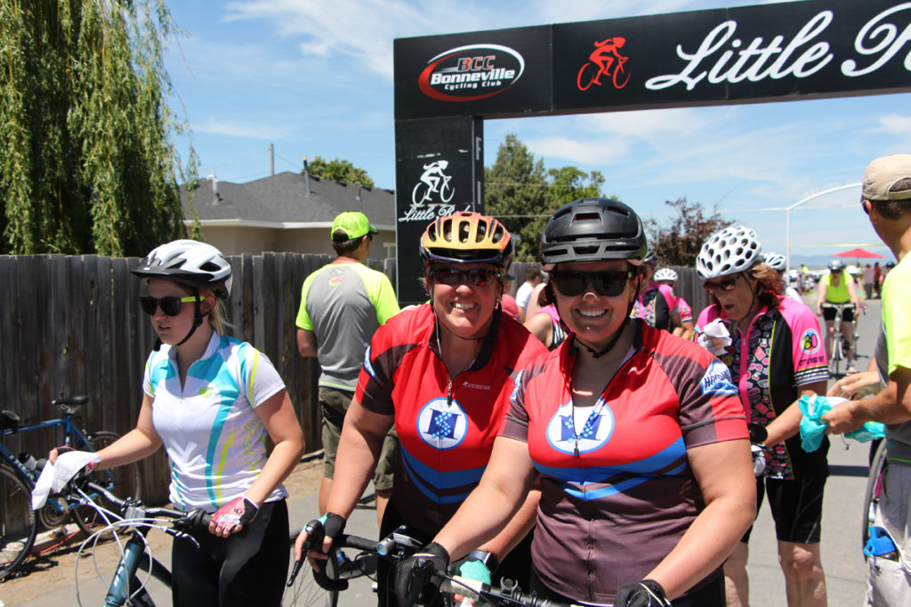
[Editor’s Note: Although the Little Red ride is cancelled for 2021, The Huntsman SportsFest is happening this year on June 12. Read about how a group of riders is helping the Huntsman Cancer Foundation. This story is from 2018.]
By M. Porter Sproul — Everyone is familiar with the tale of Little Red Riding Hood. The tale of a young girl and her grandmother who are saved from a hungry wolf by a huntsman in the woods.
Little Red Riding Heroes. Photo courtesy Huntsman 140
In our story, Little Red Riding Hood is the Huntsman’s hero when she dons a jersey and joins the fight against a different kind of hungry wolf. And the woods, are northern Utah.
For the past 30 years, women have banded together in the beautiful Cache Valley to participate in Little Red Riding Hood (LRRH), a non-competitive cycling event celebrating the strength of women against the beastly disease of cancer. LRRH has become a widely loved and acclaimed event due to its celebratory atmosphere, annual themes, great food, over-the-top decorations, and commitment to supporting women through charitable giving to Huntsman Cancer Foundation (HCF).
“We get bigger and better every year,” said Curt Griffin, LRRH’s race director. “We love to party all weekend long with these amazing women, but what makes Little Red truly special are the big hearts of our participants and their commitment to helping us raise money for women’s cancer research at Huntsman.”
LRRH has valued women’s health since its beginning in 1988 and decided to team up with Huntsman Cancer Foundation (HCF) in 2001 to support breast and ovarian cancer research at Huntsman Cancer Institute (HCI). LRRH does this by donating a portion of each registration fee, hosting a silent auction at the finish line, and by giving 150 guaranteed entries to the ride to the Huntsman Heroes (HH) cycling team.
The HH cycling team is a community group of passionate cyclists and fundraisers who support cancer research while training for some of Utah’s top endurance events. The team has members of all skill levels, training for event distances from 25 miles to over 200 miles.
Jill Callahan of Jackson Hole, WY, joined the HH cycling team in 2015 for the sole purpose of skipping the race lottery and receiving a guaranteed entry to LRRH.
“Being able to support a good cause was a bonus,” Callahan said. “Now it has become much more meaningful. I have dear friends from Jackson who have received treatment at Huntsman and I know how critical it is for our entire region.”
Like Callahan, many women join LRRH because of the impact cancer has had on their lives. Sarah Thoms, a resident of Salt Lake City, UT, is a cancer survivor who will be riding LRRH for her third year as a member of the team in June.
“A small spot of basal-cells on my shoulder led to an aggressive surgery to remove a large amount of tissue from my shoulder, and lymph nodes from my neck and armpit,” said Thoms. “Everyone’s life has been affected by cancer in one way or another. It’s amazing to see so much generosity, and be able to ride with a group of other tough women.”
Reflecting on her fundraising experience, Thoms said it was easier than she had originally thought it would be.
“With an email to friends and family and a Facebook post, I had reached my goal!”
Elfi Ortenburger, originally from Bürgstadt, Germany, and now a resident of Salt Lake City, UT, has always had a strong love of charity work and helped start the Huntsman Heroes program in 2004 after moving to Salt Lake City. Ortenburger is also the captain of the Miles For Marie HH team, which was started in honor of a fellow team member who passed away from cancer.
“I love the event, and cycling in my Huntsman jersey makes me feel proud and special,” Ortenberger said. “I love the extra support we get for being on the Huntsman Team and together we raise money and make a difference in the fight against cancer. The fundraising part has not been difficult for me and so I keep coming back and hoping someday we find a cure.”
Jen Murano, director of events at HCF, provides fundraising and event support at LRRH each year.
“It has been amazing to see the event continue to grow over time,” Murano said. “Last year, our Little Red Heroes raised $111,402 which put them over the one-million dollar mark since they began supporting us. It’s been an incredible partnership that we are excited to continue for many years to come.”
To recognize years of support, HCI named its multipurpose room the Bonneville Cycling Little Red Riding Hood Multipurpose Room.
Nancy Ward, from Salt Lake City, rides each year in honor of her sister, Susan, who passed away from ovarian cancer. She and three of her family members started the HH team, Fourward, which grew to nine members last year and raised over $6,000.
“It was devastating to lose our adored sister and friend. Truly she was the glue that held our family together,” said Ward. “We admire Huntsman for its passion to find a cure for cancer. It seemed a natural and perfect opportunity for my family to join Huntsman Heroes to fundraise in memory of Susan.”
The HH team is open to anyone who wants to join and there are still guaranteed spots available for the 2018 LRRH ride. Additional information about joining the team can be found by visiting www.thehuntsman.org/littlered, emailing [email protected], or by calling HCF at (801) 584-5800.
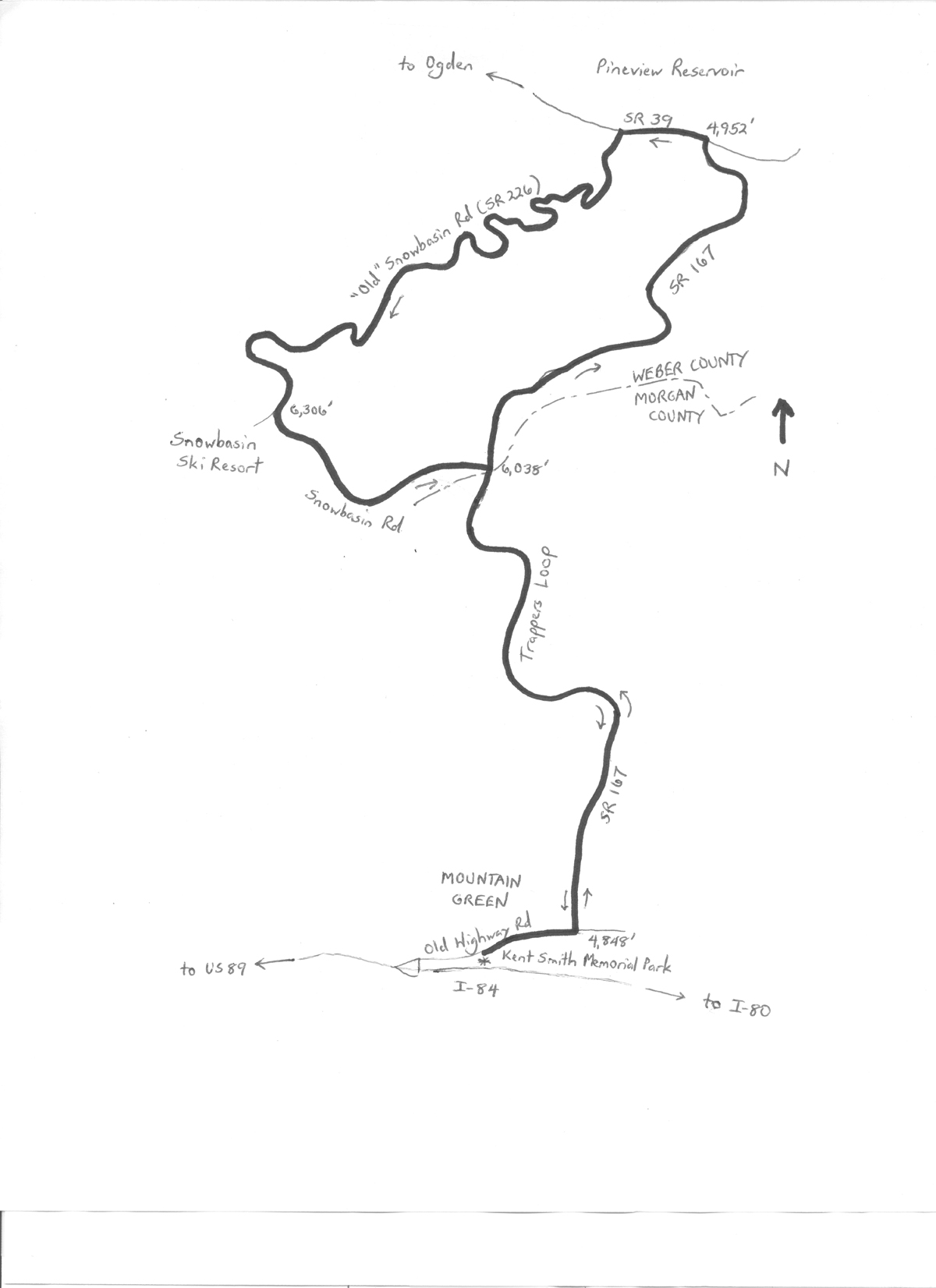
By Wayne Cottrell — Trappers Loop is the name of the highway that connects Ogden Valley with Morgan Valley, traveling up and over a ridge in the Wasatch Mountains. A bike ride including Trappers Loop is a rite of passage for many Utah cyclists, making this a popular route. This version of Trappers Loop – the bike ride – starts and finishes in Mountain Green, using Trappers Loop (which is State Route 167) outbound, and Snowbasin Road (State Route 226) inbound. The 26.65-mile ride packs 2,880 feet of climbing, although none of the climbs are steeper than a 6% grade. Nearly the entire ride is within the Uinta-Wasatch-Cache National Forest, even the lower elevation portions.
The Trappers Loop highway commemorates the era of fur trappers, who frequented northern Utah during the early 19th century. Their era post-dated the long history of Native American tribes, and pre-dated the arrival of Mormons. The community of Mountain Green, where the ride starts and finishes, was the legendary meeting point, in 1825, of three prominent trappers: Peter Skene Ogden, John Henry Weber, and Étienne Provost. Each man traveled with a team of trappers. While Ogden and Weber disputed territory, it was actually the Canadian Provost who had a legal claim to the land in the area. You can retrace some of the steps that those hardy pioneers took by completing this ride.
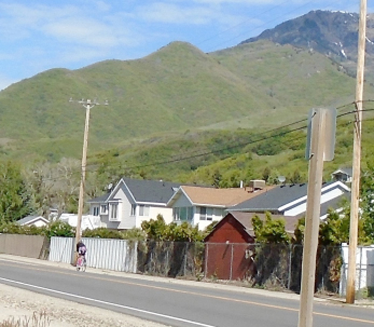
Start at Kent Smith Memorial Park in Mountain Green. Although “memorial park” might conjure up an image of a cemetery, this park features ball fields, volleyball nets, picnic tables and playground equipment. The park is located at 5457 West Old Highway Road (also known as Old Highway 30, and as State Route 167). From Salt Lake City, head north on I-15, exit to U.S. Highway 89 north, and then head east (south) on I-84. Take the very first exit after leaving Weber Canyon; turn left, and then turn right onto Old Highway Road. The park will be on the right. Mountain Green is an unincorporated community that is the gateway to Morgan Valley when coming from the west. The starting elevation is 4,848 feet; head east on the road. At mile 0.4 (there is a convenience store on the corner), turn left to head into the mountains, on State Route (SR) 167. The climb is not particularly steep, starting at a 3% grade, and then increasing to 4%, but it is steady. The highway finally crests at mile 5.85, at the junction with SR 226 (Snowbasin Road). Keep straight here – the route returns to this junction later. Your elevation is 6,038 feet. After about one-half mile of false flat, SR 167 descends. The highway is steeper on this side of the ridge (6% grade) than on the side that you climbed. The descent is somewhat dramatic, with a sweeping curve to the left, and then to the right as the highway starts to level. Picturesque Pineview Reservoir is in view in the distance. Turn left onto SR 39 at the bottom (mile 9.9, elevation 4,952 feet), and ride along the south side of the reservoir. There are a few lakeside residences, as well as Anderson Cove Campground. After just under one mile, watch for motor vehicle traffic, and make a left turn onto Snowbasin Road (SR 226) to begin the ascent (mile 10.85).
A rider speeds along Old Highway Road in Mountain Green, near Kent Smith Memorial Park. Photo by Wayne Cottrell
While SR 167 is comparatively sleek, with its high-speed turns and steady grades, Snowbasin Road is a classic, winding, two-lane mountain road. There are plenty of twists and switchbacks as the road makes its way up the mountain, at an average grade of 6%. Please note that this is the “old” Snowbasin Road, in that this was formerly the main access to the Snowbasin Ski Resort. With the newer road connecting to SR 167 toward the top of the ridge, the older road receives minimal maintenance, and is in fact closed during the winter. Some have noted that the road even moves on the underlying, unstable soil, making for an uneven road surface in places. A segment of the road was indeed closed for several years during the early 2010s, but it has since reopened. Ensure that the road is open before venturing out; the best resource would be the Utah Department of Transportation. The road straightens after crossing East Fork Wheeler Creek – but the climbing continues! The access road to the Snowbasin resort is at mile 17.8, at an elevation of 6,306 feet. The resort welcomed several of the alpine skiing events of the 2002 Winter Olympic Games, including downhill, super G, and alpine combined (downhill and slalom). The men’s events were dominated by skiers from Austria, Norway, and the U.S., who won all nine medals. The women’s events were dominated by Janica Kostelić from Croatia, who won two of the three events, including a whopping-for-skiers 1.5-second margin in the combined. The men’s downhill course, designed by Swiss Olympic champion Bernhard Russi, started at an elevation of 9,288 feet, and featured over one-half mile of vertical drop at an average grade of 31%!
The climb continues beyond the access road, finally reaching a crest at mile 18.75 (elevation 6,623 feet). The descent begins immediately (6% grade), although there is a short uphill after about one mile. The descent continues from there. Turn right onto SR 167 at the end of Snowbasin Road (mile 20.8), and enjoy the long downhill into Mountain Green. Turn right at the bottom, onto Old Highway Road (cosigned as SR 167), and return to Kent Smith Memorial Park, which will be on the left.
For more rides, see Road Biking Utah (Falcon Guides), written by avid cyclist Wayne Cottrell. Road Biking Utah features descriptions of 40 road bike rides in Utah. The ride lengths range from 14 to 106 miles, and the book’s coverage is statewide: from Wendover to Vernal, and from Bear Lake to St. George to Bluff. Each ride description features information about the suggested start-finish location, length, mileposts, terrain, traffic conditions and, most importantly, sights. The text is rich in detail about each route, including history, folklore, flora, fauna and, of course, scenery.
Wayne Cottrell is a former Utah resident who conducted extensive research while living here – and even after moving – to develop the content for the book.