The Sedona Mountain Bike Festival is a 3 day festival, held in Sedona, Arizona from March 2-4, 2018. Highlights include massive bike demo and expo, beer garden, tons of singletrack, and mtb culture in the red rocks. We caught up with Jason First of Over the Edge Sports and asked him about the event.
Cycling West: Tell us about the festival. What are some of the highlights? The Festival raises funds for trails. Can you tell us more?
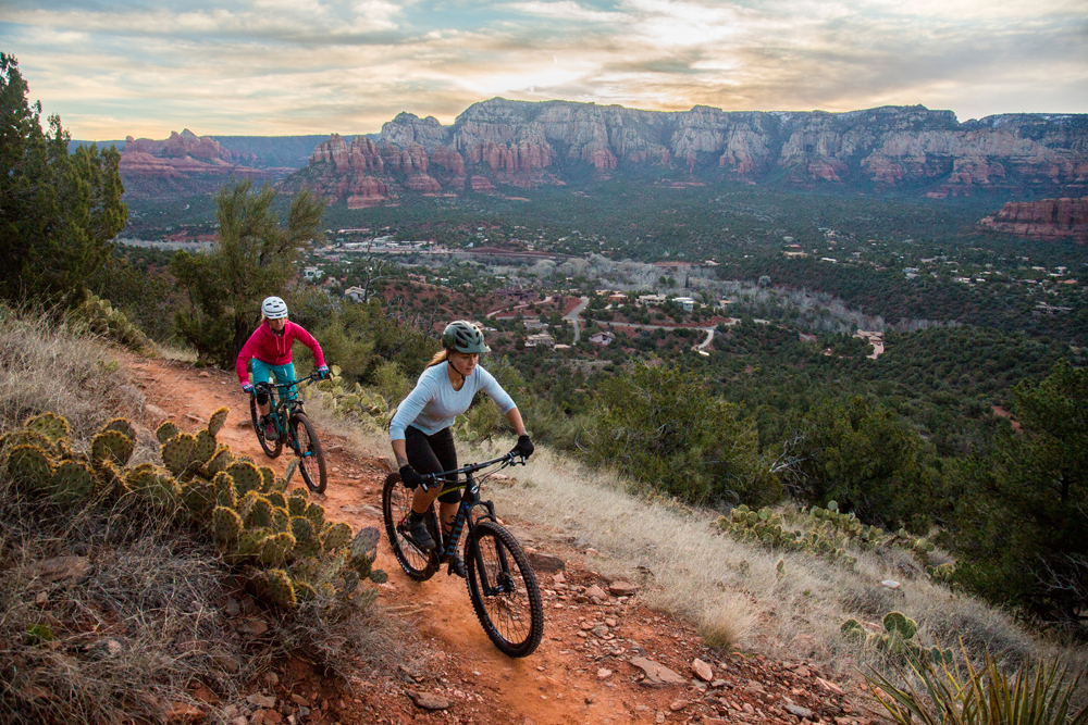
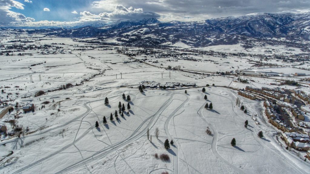
Riding just above town along “Airport Mesa” at the Sedona Mountain Bike Festival. Photo by Devon Balet
The real highlight here is providing the most entertaining weekend of riding in Sedona. The event is about mountain bike culture and it’s for everyone, there is no race or competition, it’s all about a weekend of fun riding with your friends, geeking out over the latest bike products, and sipping some beers in between. We understand bringing in so many people can cause some wear and tear to the trails, and we’ve used this platform to be the largest fundraiser for the Sedona Red Rock Trail Fund – which is a key local group in working with the Forest Service and maintaining the trails we have.
Cycling West: What are the ride offerings? Are they guided or self-guided?
The ride offerings are a mix of both guided and self-guided, something for everyone. Many of the exhibitors will be offering a group ride, with a representative or sponsored rider of the company being the guide. We have Hermosa Tour Company offering shuttle drop offs at trail heads all over town, which helps spread everyone out on different trails. We also have a few “demo” loops marked out with ribbons on trails right next to the Festival venue, and provide handout maps to self guide your own ride.
Cycling West: There will be skills clinics for women, and for all riders. Tell us about each.
We are stoked to have the Vida Women’s Series back again, last year was a big success with them; more than just riding skills, they’ve got yoga, happy hours, and women’s tech clinics going on. We’ve also got free skill clinics going on with pro racer Krista Rust and Trials legend Jeff Lenosky. It’s really an opportunity for everyone to learn something and become a better rider, beside just conquering some of the challenging red rock moves.
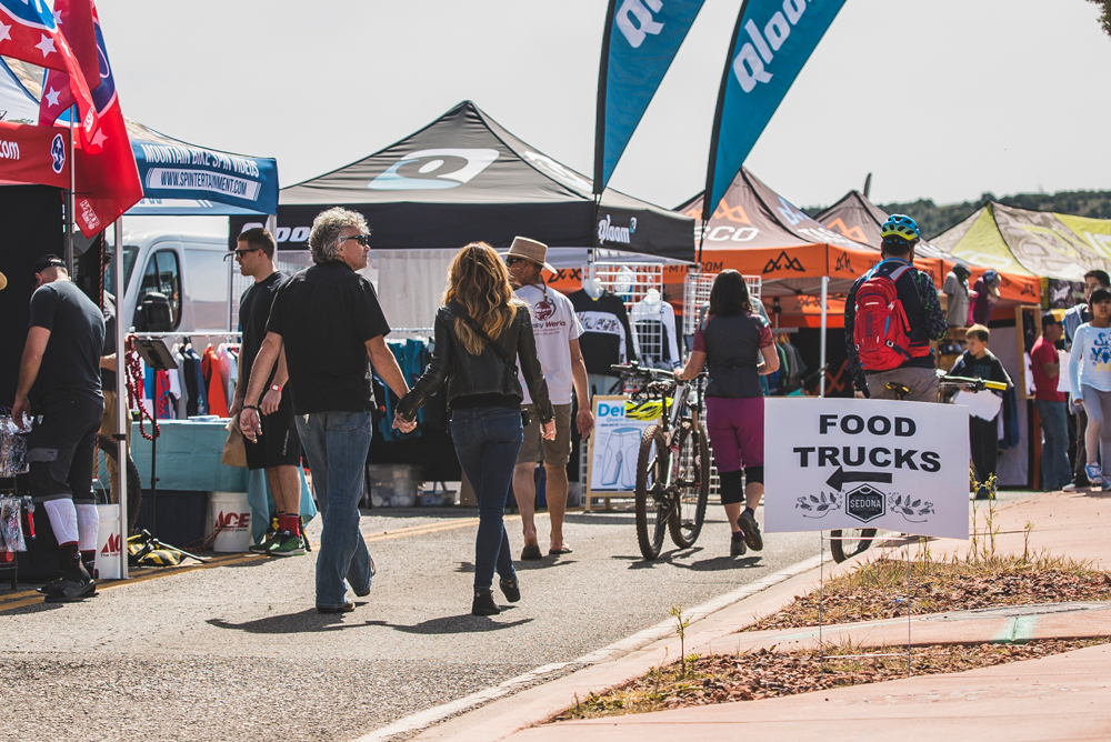
Rides, music, food trucks, bike company tents, and more are to be found at the Sedona Mountain Bike Festival. Photo by Devon Balet
Cycling West: What activities are available for families?
Outside of all the bikes – families are free to walk through the event, check out the live music and beer garden on hand. There are also quite a few non-bike companies exhibiting products to check out. We’ll have several info tents and maps that can point you in the right direction for hiking or finding the best views.
Cycling West: What is the history and natural history of the area? (e.g when was it settled, and why? What sorts of desert plants and animals are there?) Can you tell us what sites riders will see?
Well, Sedona was created by the Vortex phenomenon of electromagnetic energy in the earth’s surface. This may or may not be real 😉 but I can assure you that the riding is real and riders can expect to see stunning red rock formations and landscapes right from town and from the Festival venue. Being at 4500’ elevation, we do get more plant life and water than many people expect. And the most odd animal we have is the Javelina, which you might catch a glimpse of in the evening hours out on the trails.
Cycling West: Is there anything else that you would like to add?
I think we have a really fun weekend ahead for everyone, it’s a great opportunity to ride somewhere epic while winter is still in effect most places. We’re trying to have a relaxed environment while also having the latest and greatest from the industry. Expect to see product launches of new 2018 product from some very notable brands. It really is Sedona mountain biking served up on a silver spoon for a weekend, and open to all levels of riders.
Event Details:
March 2-4 — Sedona Mountain Bike Festival, Sedona, AZ, Held in the heart of Sedona next to trails, bike park, and downtown. Main Expo/Festival area at the beautiful Posse Grounds Park, Bike Demos, Shuttled Rides, a Beer Garden, great Bands, and endless singletrack., Sedona MTB Festival, 928-282-1106, [email protected], sedonamtbfestival.com
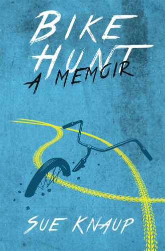
Sue Knaup found a unique way to donate bicycles. Some organizations fix up used bikes and donate them to underprivileged children. Some ship them overseas to less wealthy communities. Many of us donate bikes to charity when we get a new one or our children outgrow them.
But whenever she travels, this long-time professional bicycle advocate finds an old bike, fixes it up, rides it around town as her main source of transit, then finds someone who needs a bike and gives it away. She described years of such buys and giveaways in a recently self-published Bike Hunt: A Memoir.
Knaup founded and runs One Street, a non-profit devoted to helping bicycle advocacy groups domestically and internationally.
Bike Hunt by Sue Knaup chronicles her adventures in giving away bikes and bike advocacy.
Her tome tells two stories at once, documenting personal bike hunts/donations and her hard times as executive director of a national bike promotion group called the Thunderhead Alliance (which later morphed into the Washington, DC-based Alliance for Biking & Walking and eventually folded itself into the League of American Bicyclists). About as often as she tells you about her new old bike, she tells you how the board was trying to sabotage her work or get rid of her. Knaup often changes gears in the book so fast that you never know when she’s going from telling you about the latest bike she fixed up to her latest recount of mistreatment or vice versa.
At one point, for instance, she relates to a partially disabled homeless shelter resident she donates a clunker to:
“’I named her the Iron Maiden,’ I said. ‘You feel her weight?’” (Knaup named every bike she bought.)
“’Oh, yeah,’ he said. ‘That’s cool,’ he said with a daring grin as he gazed at all sides of his new ride. ‘That’s the perfect name for her.’
At this, the group erupted into hoots and applause.”
Then without warning, the next paragraph begins “February 2006 arrived too soon and with it the same dread I’d felt before that October board meeting in Chicago.”
The bike buy-and-giveaway log takes us from Knaup’s hometown of Prescott, AZ to Idaho, Germany, Spain and plenty of other destinations, where she roamed wherever she needed to find a two-wheeler, be it a bike outlet, secondhand store or pawn shop. The vehicles obviously needed some tune-ups and other work. Understandably, bike shop owners didn’t want to hand her the tools to do her own repair jobs, but auto service centers, who weren’t losing business by letting someone fix a bike, were more cooperative.
The book shows that you can always find somebody who needs a bike without resorting to Craigslist or Goodwill. Customers ranged from “a somewhat overweight middle-aged man dressed in colorful rags, settled on a bench, his dreadlocks bundled under a billowing knitted cup of yellow, red and green” in Victoria, BC to “a young man working at a candy shop near downtown Munich.”
So far, Knaup has bought and donated 46 bicycles. She records them all on an Excel spreadsheet. She managed to write about every one of them through publication time in the book. “When I did the first book draft, it was a struggle; I wanted every bike hunt in there but I was running out of space. In the last draft, I got every bike hunt in there, even if only just a line,” she said in an interview.
She says she aims to spend about $50 for a bike, though it averages about $40, she estimates, because sometimes she’d find one for $9 or $10. The most she spent totaled $120 in Switzerland because she ran out of time and needed one in a hurry.
While acknowledging her habit requires some mechanical skills and isn’t for everyone, “I pay $50 and have the bike with me all the time,” which beats rentals or bikeshare for price and convenience.
She doesn’t know what happens to the bikes she donates. “One of my rules is I’d make it very clear that as soon as I turned my back, it was their bike and they can do anything the want with it,” she says. But “I wanted to make sure they intended to keep the bike and take care of it. I didn’t want to give it to someone who (figured) ‘I could sell this thing for $20 around the corner.’”
Knaup self-published the book, explaining “I did try going to agents for the big (publishing) houses. They got cold feet because it’s a memoir and memoirs aren’t selling.”
Bike Hunt: A Memoir, 222 pages, paperback, One Street Press, $17.99 plus $5.99 shipping, onestreet.org.
Fat Bikers Return to Ogden, Utah for Sweaty Yeti Fat Bike Race
Ogden, Utah – Press Release – Registration for the 2018 Sweaty Yeti Fat Bike Race is now open! The second annual race will be held at North Fork Park in Liberty, Utah on February 3, 2018. This event will take youth, beginners, and amateurs between 10 – 20 kilometers around North Fork Park and pro/open riders will compete on 30 kilometers of flowy, challenging, spectator friendly terrain.
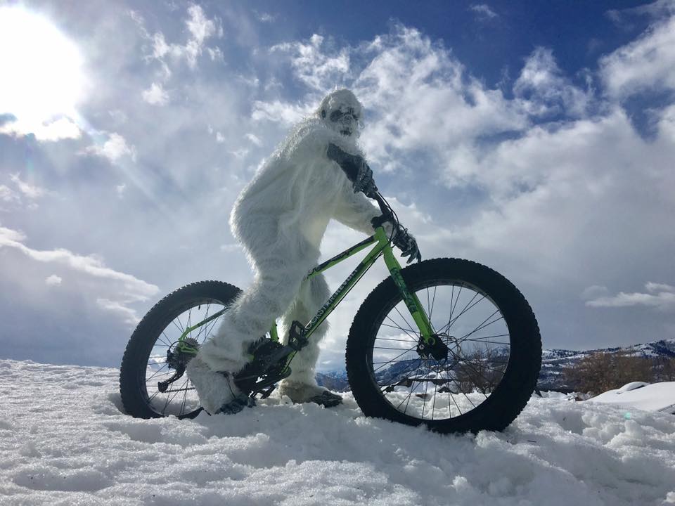
Yeti sighting! The Sweaty Yeti Fat Bike Race and Festival will be held at North Fork Park in Eden, Utah on Feb. 3, 2018 Photo courtesy Visit Ogden
“We are excited to welcome cyclists of all age and riding capabilities to the second annual Sweaty Yeti Fat Bike Race,” stated Visit Ogden CEO, Sara Toliver. “We created a race for everyone from the hard-core athlete to those who just want to get out and play in the snow with this fun, affordable and unsanctioned race in the Ogden area.”
Riders will enjoy 360-degree views of the Wasatch Mountain Range, and might even spot the infamous Wasatch Yeti during the race. No previous fat biking experience is needed to compete, just the familiarity of riding a bike and having a good time.
“Biking has quickly grown as a year-round sport and we are thrilled to introduce people to the sport and welcome back fat bike innovators,” said Toliver. “We have put a lot of time in developing the ideal course for racers to have a good time while maintaining a competitive edge.”
All races and events are open to the public, with race divisions split into age groups and a select number of pro/open divisions for men and women. The day features pro, amateur, beginner, and youth races, food trucks, beer stands, live music, a sledding hill and family fun. During the events, spectators can experience the rush of riding a fat bike through free bike demos provided by Borealis and local bike shops. Spectators will also have an opportunity from Rockstar to win a Fat Bike of their own during the event.
In addition to the Sweaty Yeti Fat Bike Race, those looking to beat the winter doldrums can also look forward to the Wasatch Yeti Bash at the Ogden Union Station. The Bash will take place Friday, February 2 from 4-8 p.m. and includes a winter arts market and interactive art by Nurture the Creative Mind, fat bike demos provided by local bike shops, yeti yoga by AndShesDopeToo, yeti sightings, live entertainment, s’mores, beard competitions and costumed fun for all ages.
The Sweaty Yeti Fat Bike Race and Festival will be held at North Fork Park in Eden, Utah on Feb. 3, 2018 Photo courtesy Visit Ogden
Fat Bike 101
A Fat Bike, also called fatbike, fat-tire bike, or fattie, is an off-road bike with oversized tires, typically 97mm or larger, and rims 66mm or wider. Their voluminous tires are designed for low ground pressure to allow riding on soft unstable terrain such as snow, sand, bogs and mud. Fat biking is similar to mountain biking, and can be ridden in most places year-round.
Beginner Yeti (10K)
$30 early bird registration (before January 1st)
$35 January 1-31st
$40 after January 31
No day of registration
Young Yeti (Junior) (10K)
$15 early bird registration (before January 1st)
$20 January 1-31st
$25 after January 31
No day of registration
Amateur Yeti (20K)
$30 early bird registration (before January 1st)
$35 January 1-31st
$40 after January 31
No day of registration
High School Yeti (20K)
$20 early bird registration (before January 1st)
$25 January 1-31st
$30 after January 31
No day of registration
Pro Yeti (30K)
$35 early bird registration (before January 1st)
$40 January 1-31st
$45 after January 31
No day of registration
Admission to the event is FREE for spectators. Festival activities include a snow sports expo, free fat bike demos, kids zone, sledding hill, beer and food trucks and a DJ. There is plenty of free parking at the venue and a variety of attractions in the Ogden area for those extending their stay.
Schedule of Events
Friday, Feb. 2: Wasatch Yeti Bash: Winter Festival at the Ogden Union Station, Ogden, Utah
4-8 pm | Wasatch Yeti Bash
4-8 pm | Winter Arts Market by Nurture the Creative Mind and Winter Sports Expo
4-8 pm |Sweaty Yeti Packet Pickup and Registration
5:30-6pm | Yeti Yoga by AndShesDopeToo
6 pm | Yeti Beard Competition
6-9pm | First Friday Art Stroll
*Other activates at the Yeti Bash include free fat bike demos, beer garden, DJ, live entertainment, s’mores, interactive art activities and more.
Saturday, Feb. 3: Sweaty Yeti Fat Bike Race, North Fork Park, Liberty, Utah
8 am – 30 minutes prior to race start | Packet Pickup
9 am-2 pm | Sweaty Yeti Fat Bike Race | North Fork Park| FREE to Spectate
9 am-2 pm | Sports Expo, Sledding, Music, Snowshoe & Fat Bike Demos, Family Activities and more!
9:30 am | Beginner & Junior Yeti (10K = 1 lap)
10:30 AM | Amateur & High School Yeti (20k = 2 laps)
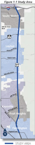
January 16, 2018 – The Utah Department of Transportation is working towards converting US Highway 89 from Fruit Heights to I-84 in South Ogden, Utah from a highway to a closed access freeway where bicycles and pedestrians would not be allowed. The controversial conversion is in study form currently. A public hearing is scheduled for January 18, 2018, and public comments are being accepted via email as well.
The study doesn’t account for current bike and pedestrian use of the existing shoulder of 89 and only mentions nearby bike and pedestrian facilities.
Regarding future bike and pedestrian facilities, the study refers to future plans by the local communities for bike and pedestrian facilities (not by UDOT):
Bicycle Lanes
Additional bicycle lanes are planned along US-89 from Nicholls Road in the south to the South Weber town limit in the north. Bicycle lanes are also planned on South Weber Drive, SR-193, Oak Hills Drive, Crestwood Road, 400 North, Country Road, Green Road, Nicholls Road, Mountain Road east of US-89, and Farmington Main Street.
Shared-Use Paths
Local plans show a shared-use path along US-89 between Farmington Main Street and Oak Hills Drive.
Additional paths cross or intersect US-89 in the following locations:
• Bair Creek (see Map 4 in Volume 2)
• Mutton Hollow Road (see Map 7 in Volume 2)
• Oak Hills Drive, leading to Holmes Reservoir (see Map 8 in Volume 2)
• Gordon Avenue (see Map 10 in Volume 2)
• Kays Creek/Layton Ridge Drive (see Map 13 in Volume 2)
• Weber-Davis Canal (see Map 15 in Volume 2)
• South Weber Drive (see Map 16 in Volume 2)
• Weber River (see Map 17 in Volume 2)
A connector trail also links the Weber-Davis Canal Trail and Weber River Parkway Trail along the west side of US-89 (see Maps 15, 16, and 17 in volume 2).
Highway 89 from Fruit Heights to S. Ogden, Utah may be converted to a closed access freeway which would eliminate bicycle and pedestrian access. Graphic from the Draft Study.
Commentary by Cycling Utah (submitted to UDOT):
The 2018 Revised Draft US 89 State Environmental Study completely minimizes the importance and current use of the 89 corridor for bicycles. It only looks at existing bike lanes, and disregards the current use of the shoulder of 89 for bikes and pedestrians. Additionally, there is little information on the replacement route in the document suggested by Wayne Bennion of WFRC. A shared use path can be ok, but can have huge issues if not done correctly. While UDOT is revamping the freeway, they are not properly accounting for the current use of the corridor by cyclists and pedestrians.
From the study, it appears as though UDOT is leaving it up to the local communities to replace bike access on the frontage roads and the crossings of 89. This may or may not happen and is not dependent on the project. UDOT is removing access, but not replacing it. The highway should not be converted unless the full complement of bike and pedestrian facilties is in place prior to conversion. This should be a requirement of the project.
In addition to the impact to local cyclists and pedestrians, the freeway would effectively eliminate the Morgan Loop recreational bike route (Salt Lake City to I-84 via Highway 89, then on I-84 to the backroads by Morgan, East Canyon, to Emigration Canyon/Little Mountain Summit), and back to Salt Lake City.
The draft study is inadequate and should be reworked to properly account for bicyclist and pedestrian use of the corridor.
Additionally, from a traffic demand perspective, the conversion of the highway will only lead to induced demand, and will not solve the transportation issues in the corridor. There is only 1 mention in the document of ‘mass transit’, and minimal mention of UTA. Only 2 bus routes currently serve the corridor, and no rail service. The study does not appear to mention increased or added rail service on the corridor. UDOT seems to be moving forward with doing the same thing, and expecting new results.
The entire study should probably be redone to account completely for alternative transportation forms, both existing and planned.
Four WorldTour Teams among early commitments for cycling stage race on Aug. 6-12
Race Returns to Southern Utah and Park City in 2018
Press Release – SALT LAKE CITY, Utah (January 10, 2018) – Organizers of the Larry H. Miller Tour of Utah announced today the dates, host venues and early inclusion of four Top 10 UCI WorldTour teams for the 2018 edition of the week-long men’s professional cycling race known as “America’s Toughest Stage Race.”
The 14th edition of the Tour of Utah will be held on Monday, Aug. 6 through Sunday, Aug. 12, 2018 – a week later on the international cycling calendar than the previous four years. The Tour of Utah will start in St. George for the first time with a prologue and conclude in Park City after six days of stage racing. Additional host cities or venues are Cedar City, Payson City, Antelope Island State Park, Layton City, Salt Lake City, Canyons Village, and Snowbird Resort.
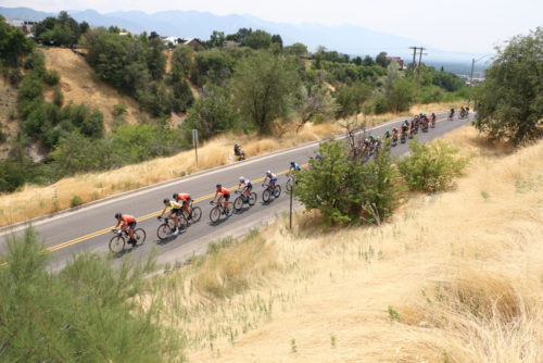
The Tour of Utah returns to Salt Lake City in 2018, as well as Park City. It will start in St. George. Photo by Dave Iltis
“The Larry H. Miller Tour of Utah will break new ground with its southernmost start amid the red rocks of St. George before traveling north to the ultimate finish line in Park City,” said John Kimball, managing director of the Tour of Utah. “The 2018 race will captivate fans across the state, showcase the beauty of Utah and demonstrate the diversity of our communities and terrain. With an initial commitment from four WorldTour teams, we look forward to hosting a world-class peloton in Utah.”
Here is the lineup of host cities and venues:
2018 Larry H. Miller Tour of Utah
Stage
Date
Host City/Venue
Prologue
Monday, Aug. 6
St. George
1
Tuesday, Aug. 7
Cedar City
2
Wednesday, Aug. 8
Payson City
3
Thursday, Aug. 9
Antelope Island State Park to Layton City
4
Friday, Aug. 10
Salt Lake City
5
Saturday, Aug. 11
Canyons Village to Snowbird Resort
6
Sunday, Aug. 12
Park City
The Tour of Utah remains a 2.HC-rated stage race on the UCI America Tour, making it one of the premier events for North America. The new dates provide a full week for WorldTeams to travel to the United States following the Tour de France, which takes place July 7-29, 2018. The Tour of Utah expects a field of more than 120 riders representing 16+ teams for seven grueling days of racing.
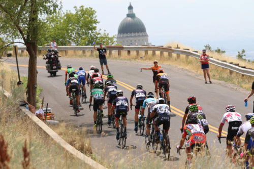
The Tour of Utah will return to Salt Lake City in 2018. Photo by Dave Iltis
The Tour of Utah has early WorldTour team commitments from the third-ranked BMC Racing Team (USA), fifth-ranked Trek-Segafredo (USA), seventh-ranked Mitchelton-Scott (Australia) and 10th-ranked EF Education First-Drapac presented by Cannondale (USA).
Competing for the 10th time in Utah, BMC Racing Team has had many successes, winning the overall team classification at the 2008, 2016 and 2017 Tour of Utah. Trek-Segafredo returns to Utah for its fourth appearance. Mitchelton-Scott is back for a second time after previously racing as ORICA GreenEDGE in 2013. This is the eighth year for a Slipstream Sports-owned team to race in Utah, returning after a one-year absence as EP Education First-Drapac presented by Cannondale.
The Tour of Utah changes each year to introduce the sport of cycling to new places and present challenging courses to the riders. St. George makes its host debut as a Tour of Utah newcomer for the prologue on Monday, Aug. 6. St. George is located in the southwestern corner near the tri-state junction of Utah, Arizona and Nevada for the opening segment of race week.
A four-time Tour of Utah host city, Cedar City will host Stage 1 on Aug. 7 and serve as the race headquarters for the overall start festivities around Southern Utah University. Cedar City offers the challenging combination of high-elevation riding in Dixie National Forest and Cedar Breaks National Monument along with the fast-paced circuits around downtown “Festival City USA.”
The classic western town of Payson City, sitting at the foot of Mount Nebo as the highest mountain in the Wasatch Range of Utah, hosts a stage for a third time with Stage 2 on Aug. 8. Stage 3 features a start at Antelope Island State Park, which is located on the largest island in the Great Salt Lake. Layton City, which hosted a start line at the 2017 Tour of Utah, will now be the finish line in Davis County on Aug. 9.
Salt Lake City, the state capital and largest city in Utah, takes center stage for an 11th time with Stage 4 on Aug. 10. The “Queen Stage” is Aug. 11 featuring a route from the Canyons Village in Park City to the traditional Saturday finish at Snowbird Resort. Park City will host the Tour of Utah for a ninth time with Stage 6. The Sunday finale on Aug. 12 will determine the overall winner of the yellow jersey for the Tour of Utah.
Details regarding each stage route such as race mileage and formats, elevation gain, and start/finish times as well as spectator festivities will be announced in the late spring.
In 2017, Canadian Rob Britton of Rally Cycling captured the overall general classification victory at the Tour of Utah which featured 605 miles of racing and 35,525 vertical feet of climbing.
Tour organizers note the event’s growth since 2011, when the race was first elevated as a UCI-sanctioned event. Television viewership has expanded with international broadcast partners providing coverage in 193 markets, and FOX Sports Network providing coverage nationally. A full week of webcasting with Tour Tracker presented by Adobe engaged 136,000 fans across 109 countries through consumption on mobile devices and the Tour’s website. The Tour of Utah is the only North American stage race that offers start-to-finish online coverage. In addition, the earned media coverage for the Tour of Utah generated $18 million in publicity value for the cycling event, as well as host communities and corporate partners.
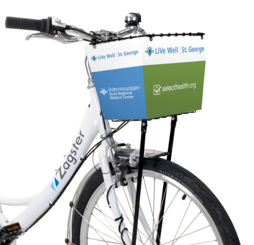
Bike Share Opens in St. George on January 11, 2018
By Marc Mortensen
St. George, Utah – December 8, 2017 – Bike sharing has emerged as one of the most successful transportation movements in North America in recent years and southern Utah is no exception. In St. George, getting around town on two wheels will become easier than ever with the LiVe Well St. George Bike Share by Zagster. Whether you’re interested in a leisurely ride on the paved multi-use paths, touring the downtown in the open air or commuting to work or class, bike share is affordable and convenient.
Bike Share is coming to St. George, Utah in January, 2018. Photo courtesy City of St. George
Zagster, one of the fastest growing bike share companies in the United States has teamed up with Intermountain Healthcare and Select Health and a host of other local sponsors like Dixie State University, Washington County Tourism Office and Brad Harr & Associates to design a bike share program that reduces carbon emissions, improves mobility and transportation options, encourages people to be physically active, reduces traffic congestion and promotes innovation.
The initial launch on January 11th, 2018 will feature 10 bike stations and 55 bikes accessible at a number of locations within a three-miles radius of downtown.
Access to a Zagster bike is right at your fingertips by following four simple steps:
How it Works
Join
On any Apple or Android device download the Zagster app and create a profile. Search the app for St. George to find station locations near you.
Choose Your Bike
At a station enter the bike’s number into the app and tap START RIDE. You’ll get a unique code to open and close the lockbox.
Unlock
Use the key from inside the lockbox to operate the U-lock that attaches the bike to its station. Be sure to shut the lockbox before you ride.
Ride
Have fun! Use the U-lock to keep the bike secure if you make stops along the way. When you’re done, lock the bike back to any Zagster station and close the lockbox. Then go to the app and tap END RIDE.
CrossVegas announces name change with move to Reno in 2018
LONGMONT, Colo. – Press Release – December 4, 2017
Clif Bar & company has committed to title sponsorship of CrossReno, the cyclocross race known for a dozen years as CrossVegas. The sponsorship announcement, and the name change, were announced by Brook Watts, owner and organizer of the popular event.
RenoCross presented by CLIF BAR will take place on Wednesday evening, September 19, 2018 following the 2nd full day of the Interbike show at Rancho San Raphael Park in Reno, Nevada.
Race director Brook Watts commented, “CLIF BAR has been a significant sponsor since the race’s first year in 2007 and the title sponsor since 2011. They have been a big part of our sustained success. It’s remarkable to have such long-term sponsors for any event. And now they’re making the journey with us 450 miles to the north to Reno.”
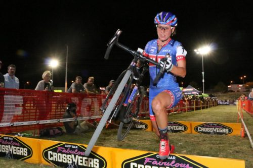
Katerina Nash on her way to winning the UCI Women’s Elite Race at Cross Vegas, September 20, 2017. Photo by Dave Iltis/CyclingWest.com
“CLIF BAR is thrilled to return as the title sponsor for 2018 RenoCross,” said Melissa Leebove, Regional Marketing Manager for CLIF. “We’re excited that the new venue will not only introduce a new challenge to the ‘cross racers, but also bring the incredibly spectator-friendly sport to the Reno community. CLIF BAR has supported CrossVegas for more than a decade; we look forward to many more years of partnership in Reno and supporting cyclocross athletes with sports nutrition for sustained energy.”
Brook Watts, owner and organizer of RenoCross continued, “Although the backdrop will change from the glitzy Vegas Strip to the stunningly beautiful Sierra Nevada mountains, the event will remain the same world-class event, supported by CLIF BAR, that racers and spectators have loved for 11 years. RenoCross will still provide industry bragging rights for the Wheelers & Dealers, VIP hospitality for sponsors, opportunities for bike industry participation at all levels and top level competition among the pro women and men.”
Watts closed by saying “We’ll have complete information about all aspects of RenoCross as we roll into the new year….watch this space!”
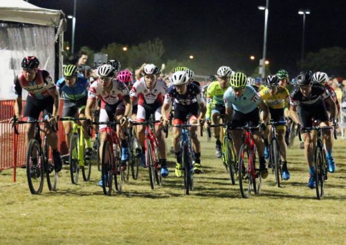
The start of the UCI Men’s Elite Race. Jeremy Powers (left) and Laurens and Diether Sweeck (1 and 2) went on to finish 3, 1, 2 respectively. Cross Vegas, September 20, 2017. Photo by Dave Iltis/CyclingWest.com
About RenoCross
RenoCross presented by CLIF BAR is organized by Watts Marketing Inc. of Longmont Colorado. With a 11- year history as CrossVegas, the event has become a fixture on the U.S. and international cyclocross calendar, as well as an integral part of the Interbike week. Complete information including schedule, hotel information and sponsorship opportunities is available at www.RenoCross.com. Follow on Twitter www.twitter.com/RenoCrossCX @RenoCrossCX
About CLIF BAR
Clif Bar & Company crafts nutritious and organic food to feed and inspire adventure, including the CLIF BAR® energy bar; CLIF Kid™, Nourishing Kids in Motion®; and LUNA®, The Whole Nutrition Bar. Family and employee-owned, the company is committed to sustaining its people, brands, business, community and the planet. For more information on Clif Bar & Company, please visit www.clifbar.com, check out our Facebook page at www.facebook.com/clifbar and follow us at: www.twitter.com/clifbar and www.instagram.com/clifbar.
Idaho Stop Bill Reintroduced in Utah Legislature for 2018
December 29, 2017 – Cyclists may soon be able to treat stop signs as yield signs and red lights as stop signs if a bill that institutes the Idaho Stop is passed by the Utah State Legislature.
Will the Idaho Stop be legal for cyclists in Utah in 2018? A new bill would allow cyclists to treat stop signs as yield signs and Ted lights as stop signs in most circumstances.
Rep. Carol Spackman-Moss has introduced H.B. 58: TRAFFIC CONTROL SIGNS FOR BICYCLES that would legalize the Idah Stop in Utah. The bill will be considered in the upcoming legislative session.
In 1982, Idaho implemented a law that allows bicyclists to treat stop signs as yield signs, and stop lights as stop signs. (See: https://legislature.idaho.gov/statutesrules/idstat/title49/t49ch7/sect49-720/ ) So far, with 35 years of history behind it, cyclists are at least as safe, if not safer with the law in place. According to a 2010 paper and presentation, “bicycle injuries declined 14.5% the year after implementation” and cities in Idaho were 30.4% safer for cyclists than comparable cities without the law. (Meggs, 2010, https://meggsreport.files.wordpress.com/2011/09/idaho-law-jasonmeggs-2010version-2.pdf and https://meggsreport.files.wordpress.com/2012/07/meggs-jason-velo-city-2012-idaho-stops-law-srv2.pdf). Utah has tried a couple of times to pass the law. The closest it came was in 2011, when it passed the house, and then failed in the senate on a tie vote. In 2010, it passed the house, but failed in the senate. More recently, Utah did pass a bill that allow cyclists and motorcyclists to proceed through a red light if the light doesn’t change within 90 seconds. This helps to remedy the issue that many stoplights are triggered by metal or weight, and cyclists and motorcyclists don’t always trigger the light to change. (41-6a-305. Traffic-control signal https://le.utah.gov/xcode/Title41/Chapter6A/41-6a-S305.html?v=C41-6a-S305_2015051220150512 )
7 LONG TITLE
8 General Description:
9 This bill modifies the Traffic Code by amending provisions related to operating a
10 bicycle on the roadway.
11 Highlighted Provisions:
12 This bill:
13 ▸ provides that a person operating a bicycle approaching a stop sign shall yield the
14 right-of-way to any vehicle in the intersection or approaching on another highway
15 so closely as to constitute an immediate hazard during the time the person is moving
16 across or within the intersection or junction of highways, except that a person after
17 slowing to a reasonable speed and yielding the right-of-way if required, may
18 cautiously make a turn or proceed through the intersection without stopping;
19 ▸ provides that once a person operating a bicycle approaching a steady red
20 traffic-control signal has stopped and yielded to all other traffic, the person may
21 cautiously:
22 • proceed straight through the steady red signal; or
23 • turn left onto a highway that is a highway with one lane in each direction; and
24 ▸ provides that after slowing to a reasonable speed and yielding the right-of-way, if
25 required, a person operating a bicycle approaching a steady red traffic-control signal
26 may cautiously make a right-hand turn without stopping.
27 Money Appropriated in this Bill:
28 None
29 Other Special Clauses:
30 None
31 Utah Code Sections Affected:
32 AMENDS:
33 41-6a-1105, as renumbered and amended by Laws of Utah 2005, Chapter 2
34
35 Be it enacted by the Legislature of the state of Utah:
36 Section 1. Section 41-6a-1105 is amended to read:
37 41-6a-1105. Operation of bicycle or moped on and use of roadway — Duties,
38 prohibitions.
39 (1) A person operating a bicycle or a moped on a roadway at less than the normal speed
40 of traffic at the time and place and under the conditions then existing shall ride as near as
41 practicable to the right-hand edge of the roadway except when:
42 (a) overtaking and passing another bicycle or vehicle proceeding in the same direction;
43 (b) preparing to make a left turn at an intersection or into a private road or driveway;
44 (c) traveling straight through an intersection that has a right-turn only lane that is in
45 conflict with the straight through movement; or
46 (d) reasonably necessary to avoid conditions that make it unsafe to continue along the
47 right-hand edge of the roadway including:
48 (i) fixed or moving objects;
49 (ii) parked or moving vehicles;
50 (iii) bicycles;
51 (iv) pedestrians;
52 (v) animals;
53 (vi) surface hazards; or
54 (vii) a lane that is too narrow for a bicycle and a vehicle to travel safely side by side
55 within the lane.
56 (2) A person operating a bicycle or moped on a highway shall operate in the designated
57 direction of traffic.
58 (3) (a) A person riding a bicycle or moped on a roadway may not ride more than two
59 abreast with another person except on paths or parts of roadways set aside for the exclusive use
60 of bicycles.
61 (b) If allowed under Subsection (3)(a), a person riding two abreast with another person
62 may not impede the normal and reasonable movement of traffic and shall ride within a single
63 lane.
64 (4) If a usable path for bicycles has been provided adjacent to a roadway, a bicycle
65 rider may be directed by a traffic-control device to use the path and not the roadway.
66 (5) (a) A person operating a bicycle approaching a stop sign shall slow down and, if
67 required for safety, stop before entering the intersection.
68 (b) After slowing to a reasonable speed or stopping as required by Subsection (5)(a),
69 the person shall yield the right-of-way to any vehicle in the intersection or approaching on
70 another highway so closely as to constitute an immediate hazard during the time the person is
71 moving across or within the intersection or junction of highways, except that a person after
72 slowing to a reasonable speed and yielding the right-of-way, if required, may cautiously make a
73 turn or proceed through the intersection without stopping.
74 (6) (a) (i) Except as provided in Subsection (6)(b), a person operating a bicycle
75 approaching a steady red traffic-control signal shall stop before entering the intersection and
76 shall yield to all other traffic.
77 (ii) Once the person has stopped and yielded to all other traffic as required by
78 Subsection (6)(a)(i), the person may cautiously:
79 (A) proceed straight through the steady red signal; or
80 (B) turn left onto a highway that is a highway with one lane in each direction.
81 (b) After slowing to a reasonable speed and yielding the right-of-way, if required, a
82 person operating a bicycle approaching a steady red traffic-control signal may cautiously make
83 a right-hand turn without stopping.
What do you need to pack for a long distance bicycle tour?
John Roberson’s List of Stuff to Bring on a Bicycle Tour
After many, many years of bicycle touring, I’ve come up with my own basic list of gear that I use when I prepare for a trip. My list has five basic categories: camping gear, clothing, food, tools and personal items. Please know that I’ve never taken everything on the list, but most of what’s there goes with me on every tour.
Like a lot of folks here in Utah, I should begin by saying that I really like to ride my bicycle. I enjoy using my bicycle to get around, and I ride for lots of different reasons. I ride a bike to and from work, and when I’m doing my around-town chores. I like that it’s easy on both the atmosphere and my wallet, and that it helps keep me healthy and fit. It’s nearly always a lot of fun, too!
Cyclists everywhere realize that a bike allows them to move around at an efficient pace while simultaneously giving all their senses a wonderfully direct connection to the environments they experience as they ride. By riding our bicycles we can literally smell the flowers as we ride.
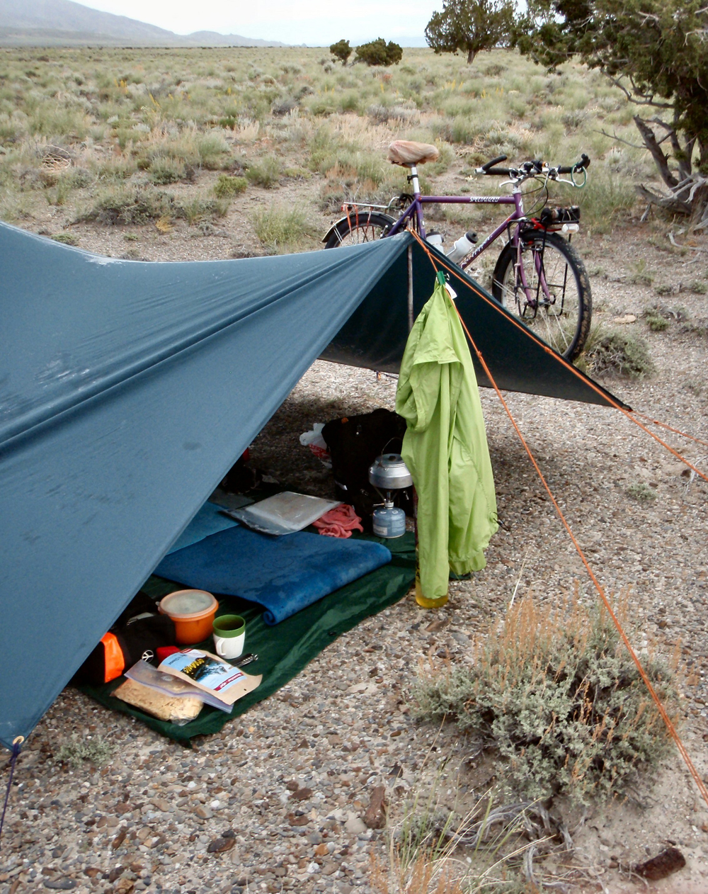
Under the tarp tent on a misty, Utah desert morning.
As any savvy traveler knows, it’s usually a good idea to be well prepared before heading out on a trip. Bicycle tourists know this, too, and we know that some circumstances require a higher level of preparedness than others. For example, an extended, self-supported mid-winter tour of the Colorado Plateau would seem to call for more thorough planning than a short, credit-card-oriented summer cruise through Utah’s northern valleys. There’s a lot to think about when planning a trip, but sensible touring bicyclists always consider the weather and temperature, the season and terrain, the company they will be keeping and the availability of resources along the way. I have found that being well-prepared minimizes unnecessary stresses and allows me greater freedom to relax and enjoy the journey.
Many bicycle tourists start the trip planning process with some kind of a list. If they have experience touring they probably have a list of their own. But if not, bike trip equipment lists can be found in abundance on the Internet and in some of the excellent guides to the state that are available. (I strongly recommend Dennis Coello’s 1984 classic BICYCLE TOURING IN UTAH.) No two lists are exactly alike, but they all have a great many things in common.
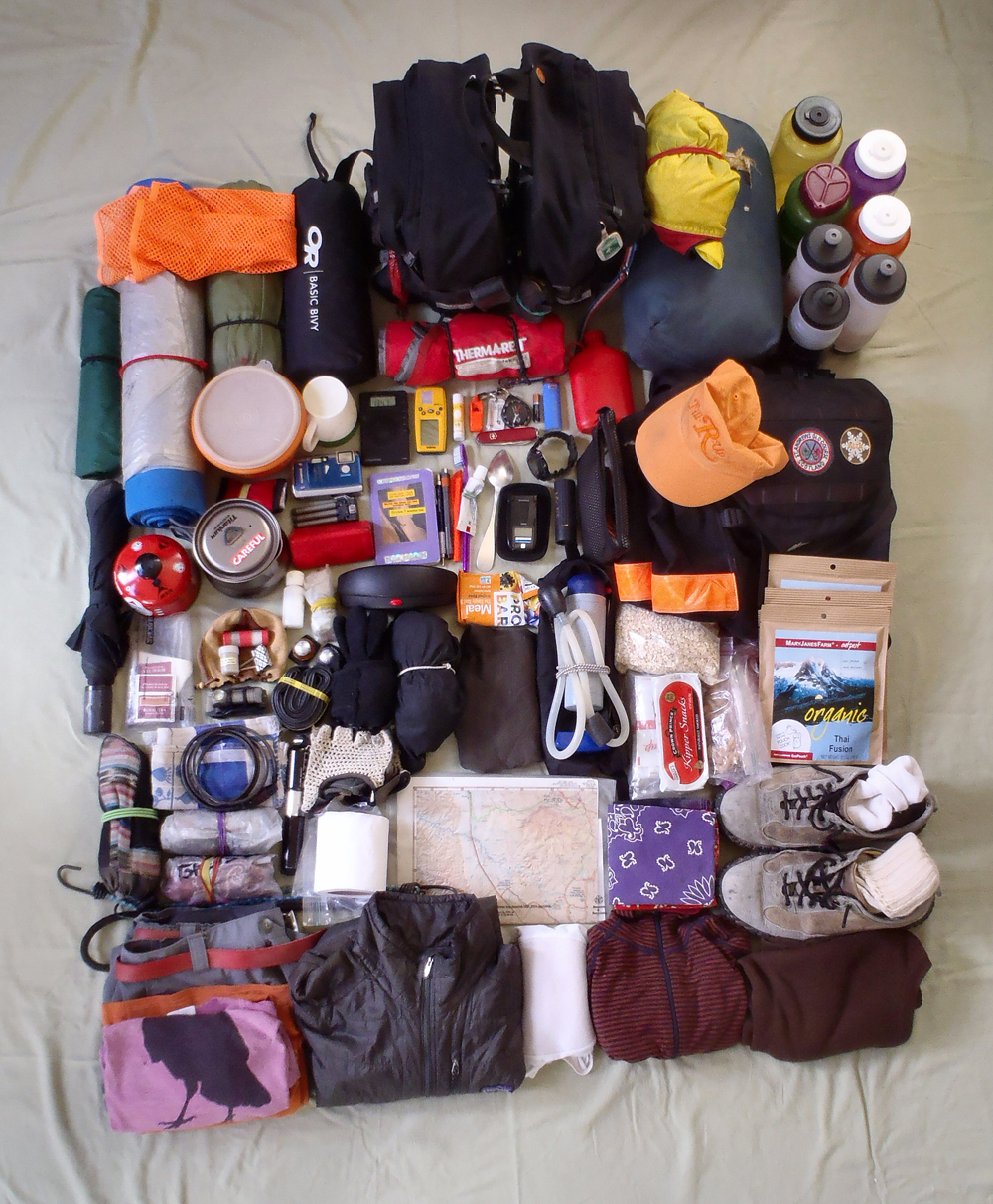
A picture of the things my bicycle carries for me.
After many, many years of bicycle touring, I’ve come up with my own basic list of gear that I use when I prepare for a trip. My list has five basic categories: camping gear, clothing, food, tools and personal items. Please know that I’ve never taken everything on the list, but most of what’s there goes with me on every tour. It all depends on the time of year, the length of the tour, the riding conditions or whether I’m riding alone or with friends. Everything I take fits into front and rear panniers or rides on top of the front and rear racks. Other than the clothing I wear, I carry nothing on my person. My total load (bike and gear) generally weighs between 70 and 90 pounds when I first start out.
I print up a fresh copy when I begin planning each trip and add notes to it as I go. It isn’t perfect, by any means, and I usually make some slight change to it after every tour, but overall, it really works quite well for me. The list below has a few notes attached for the reader’s benefit and is missing a few of the more personal items on my own list. Otherwise, it’s good to go. Enjoy!
Camping Gear
shelter: a tarp tent or small tent with fly
ground cloth
sleeping bag and a waterproof bivy sack
pads: a full-length, closed-cell pad and a tiny, self-inflating Thermarest pad
water bottles: 3 on the bike frame and 2 to 4, 1-liter bottles in my panniers
water filter
small thermos (especially nice in hot weather!)
stove, fuel canister(s) and lighter
small kettle
small, sealable Tupperware bowl and lid
insulated drinking cup and spoon
pocket knife
dish soap and sponge
dish towel
lots of spare Ziplock-type bags of varying sizes
candle or night light (for camp zone ambiance!)
headlamp (task lighting)
a simple GPS for marking camp sites (and relocating old ones!)
Clothing
rain cape (or rain jacket)
cap with a brim
cool-weather cap and gloves
comfortable shoes, flip flops
spare socks and undies
handkerchiefs/bandanas
baggy cotton shorts with lots of pockets
padded riding liners
shirts: cotton, wool; short and long sleeved
riding “tights”, long johns
wool vest and sweater
neck gaiter
cycling gloves
snow gaiters
down or synthetic-fill jacket
windbreaker
high-visibility safety vest
Personal Items
sunscreen & bug dope
small camera, batteries, tripod, lens paper
monocular, hand lens
radio or MP3 player & tiny speaker (for campsite use only!)
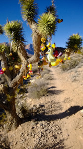
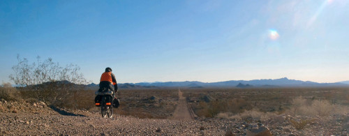
Climbing through the Joshua trees. Photo: Lukas Brinkerhoff
We walked into the middle of his explanation. Chris Tuma at McGhie’s Bike Outpost in Blue Diamond, just outside of Las Vegas, was giving trail instructions to a customer who had arrived before us. The only real way to describe this interaction is a mix of rehearsal and passion beyond what any normal trail direction giving would entail.
The first thing that I heard him say as we approached the counter was something about aliens. It quickly became apparent that this was his theme. There was a “dam” that the aliens had built and had later been eroded away. Riders were to ride around the two remaining dam points. Then there was Black Velvet “which the climbers like a lot” where the exhaust from the space ship had left black marks up the towering rock walls.
Intermingled with these tails of extraterrestrials, Chris was drawing lines on a map, describing in intricate detail land marks and junctions and at the same time running a slide show on his computer to show a visual of the area to which he was referring. The route he was giving directions for was about seven miles long. His demonstration took about 15 minutes.
And then it was our turn.
Without skipping a beat, Chris began at the beginning and went through his step by step details of how to ride the Mustang Loop or the Beginner Loop or several other names that referred to the same ride. I patiently listened and after about five minutes Chris looked up to see me smiling. The directions were so detailed that by the time we had gotten through the first mile or so of trail I couldn’t remember how to get out of the shop and onto the trail.
He looked at me and noted that seven miles might be a bit short and that after we did one lap we could go back around and extend it out past another saddle to hit around 20 miles. As he noted this, and then continued through his presentation.
We bought a map and were given a copy of what looked like a hand drawn map overlaid on a topo where Chris had drawn some boundary lines and given us more or less the idea of the lay of the land. We headed out the front door of the shop, grabbed the bikes and headed up the street. After about a block I realized I really had no idea where I was going but remember something about a real estate sign for a lot that was for sale for $259,000. After another block, I saw the sign and found my way onto the singletrack.
The Duck Tree. Photo: Kathleen Berglund
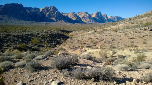
Blue Diamond is home to the Cottonwood Trails system which consists of about 125 miles of trail. The trail that Chris so passionately described to us was the Mustang Trail or Beginner Loop which is about seven miles of easy singletrack. These are desert trails that you can ride fast. They are more or less smooth with the only real obstacle being that the gravel is a little loose. Seeing that you can maintain high speeds, the gravel can make the corners difficult to negotiate. Other than that, you can just pedal and smile.
Once I found my way to the trail, I began the process of trying to remember the steps and landmarks that Chris had described. After about a half mile, I had already stopped to check the map and the notes jotted on it several times. Thanks to the level of detail given, I was able to discern the major landmarks of the area and instead of trying to follow the directions that I couldn’t remember. I just headed out on some trail.
Some of the trails were marked but most of them weren’t. It quickly came apparent why Mr. Tuma’s directions were so detailed. For someone unfamiliar with the desert or navigating without signs, the area could be a bit daunting. The one thing that served me well was the alien dam “that had been eroded through the middle leaving two ends.” By watching the points, I was able to ride without ever feeling lost. Every time I came to a fork, I just went the way that seemed the most fun or that I thought would take me farther away from the town.
Despite the fact that I didn’t follow the directions step by step, I still ended up passing by a lot of the landmarks drawn on the map. There’s the rock smiley face at the top of the first climb which is a bit of a grunt. If you make it without dabbing, you get to put a rock on the face. I passed the old abandoned car, the Black Velvet, and the countless turns that would have taken me to places that I was told weren’t worth going on a bike. Most importantly I passed the Duck Tree or more accurately, I passed under the Duck Tree. This is a Joshua tree that has hundreds of rubber ducks tied to it and the trail goes right under one of the branches. So you have to duck under the ducks.
Once the sun started to dip, I turned the tires back toward Blue Diamond and made my way around the “dam” and back to the Outpost. I rolled back into the parking lot to find the shop still open and a couple of local riders getting ready to head out. The beautiful weather that had enticed us to Las Vegas was starting to turn cold. After all it was January and the desert can be a bit moody in the winter. Chris was excited to see me return as he thought I had the last rental bike he was waiting for so he could close. He let me use the bathroom to change.
As I walked back out of the shop, Chris was showing another customer his car. To that customers surprise as to mine, it was a Ford Mustang. I’m sure that had something to do with the aliens.
Kathleen Berglund riding the smooth Blue Diamond singletrack. Photo: Lukas Brinkerhoff
Notes on the Trail:
Blue Diamond sits outside of Las Vegas and can be accessed by taking the Blue Diamond Exit off of I-15 and heading West. I highly recommend stopping in and getting directions and a trailmap from McGhie’s Bike Outpost in the center of Blue Diamond. It’s a great place to start and the staff are a hoot. McGhie’s can be found online at mcghies.com or call them at (702) 875-4820.
After the ride…
The Red Rock Campground is within a half hour of the trailhead and offers excellent camping for a marginal fee. There are plenty of hikes for the family to do in Red Rock. For dinner, The Yard at the Red Rock Casino is an excellent choice. They even have Hops Rising on tap.
Lukas Brinkerhoff blogs about mountain biking and life at mooseknuckleralliance.org.
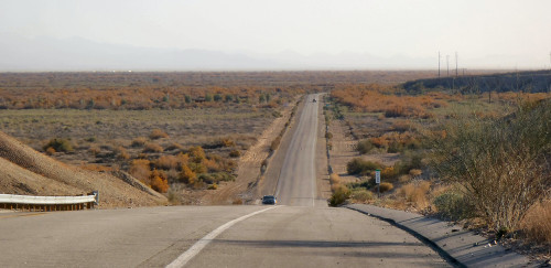
North of Blythe on the Rice-Midland Road. Photo By John Roberson
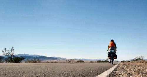
By John Roberson
It was an early morning in late December of 2014. The first day of winter was a day or two away, and I was driving south through a snow squall toward the town of Nephi, Utah. I was on my way to Needles, California, where I expected to park my truck and spend a delightful week riding my bicycle in the Mojave Desert. I had made this drive a few times before, and I was confident I’d find quiet roads, mellow temps and a lot of inspiring scenery to soothe my work-rattled nerves. It had worked for me in the past, and I had high hopes it would work again this year.
The Mojave region is a beautiful place, but I think it’s especially nice in the early winter. The sun always seems to shine, and the roads are noticeably quieter as the general public stays busy enjoying the various holidays at home. I often feel I have the peaceful desert all to myself. The days are short (the sun sets around 6:30), and the nights can seem terribly long
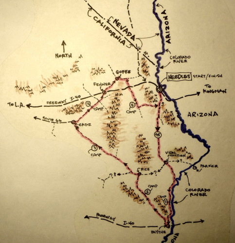
A map of John Roberson’s short tour of the Mojave Desert. Photo by John Roberson
and dark, but I don’t mind. I ride slowly and steadily during the daylight hours, and I have routines that help pass the time during the dark evenings. And I always seem to sleep very well.
After an easy, all-day drive I arrived in Needles around sunset, checked into the same cheap motel I’d used in the past, and spent the evening loading up my bike. As usual, I’d be carrying everything I might need to travel comfortably in the deserts beyond. I’d be sleeping out every night and preparing my own meals. I had a few basic tools with me and a couple of spare tubes. I had plenty of warm clothing for the chilly nights and a few “luxuries” to help ease my passage. Years of similar trips has resulted in my having a pretty reliable list of essentials to work from, and I was fairly confident I’d brought what I’d need.
Traveling south on U.S. 95 near the Colorado River, north of Blythe. Photo by John Roberson
Day One
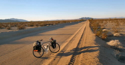
I left the motel after the rising sun had taken much of the chill out of the air and began riding slowly out of town. Needles’ roads were quiet that morning, and its dusty palm trees and mellow temps reminded me I was a long way from the winter chill of home. I had a fairly heavy load, so I started out easy, taking time to get used to the subtle changes in the bike’s handling caused by the extra weight. Most of the weight was taken up by water. I was carrying about seven liters of water in my bags and on the frame – enough to last me a few days – and that extra twenty pounds made a difference as I left town and started the gentle climb to the first pass of the day.
I was riding south on U.S. 95, a two-lane blacktop highway that runs north and south along the Colorado River. I was aiming for the town of Blythe, California, about 75 miles down the road, and expected to get pretty close before the day was done. I wanted to make the best use of the minimal daylight (roughly 9 hours, or so), so I decided to spend the day riding the highway in order to put some easy miles in and gain access to what I hoped would be some interesting backroads, further south.
I spent the morning hours climbing the gentle, eastern slope of the Sacramento Mountains, which rise to the west of Needles, stripping down to shorts and a light wool shirt as I went. I was in no
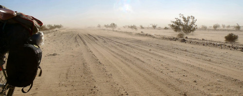
A dusty morning on the Cadiz Road. Photo by John Roberson
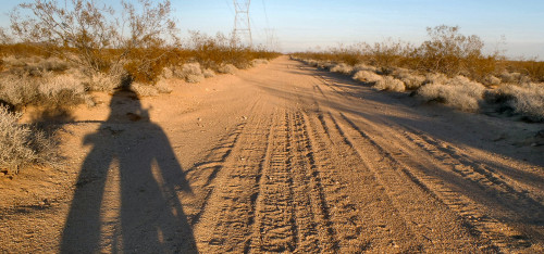
particular hurry, and I found myself stopping frequently to check out my load and the world around me. It seems there’s always something interesting to catch the eye: some intriguing, jagged mountain profile in the distance, or some “shiny object” by the side of the road. For me, bicycle touring is becoming more about slowing down and taking closer looks at what I see.
I made the first pass around midday. The traffic had picked up, and I knew from previous trips that the stretch of highway that lay ahead of me had marginal shoulders. I would have to stay on my toes. However, the Mojave roads are often arrow-straight as they cross the open desert valleys, so my views of oncoming traffic can be quite good. And Cali drivers are really pretty nice. On that particular day I had a tailwind and sunny skies, too, and the next 30 miles or so passed without mishap.
I stopped at Vidal Junction to top off my bottles and pick up a new ball cap to replace the one I’d left in my truck. There’s a small store there and an agriculture inspection station, but not much else. Both are good sources of water. The larger town of Parker, Arizona, is down the hill to the east and across the river, a few miles from Vidal Junction, but I’d never passed through to see what sorts of amenities they might have. I knew for sure that there was at least one resort in Parker because my new cap sported a logo advertising the merits of a place called The Beach.
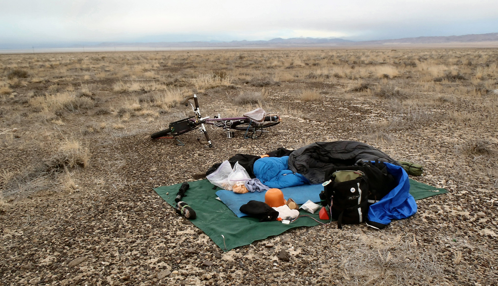
I left Vidal Junction in the later afternoon, and spent the rest of that day cruising comfortably down Highway 95, rolling up and down as the road paralleled the meandering Colorado River. The traffic had thinned south of Vidal Junction, and the shoulder had widened, so the traveling was really very cushy. I stopped to check out a set of rather famous, Paleo-Indian intaglios by the side of the road, then rolled a mile or two further down the highway to a sneak camp up on some flats above the highway. I set up my first camp on a broad swath of firm desert pavement as the sun set over the hills to the west, then settled in for what would be the first of six long, dark and chilly nights.
Day Two
On a pipeline road through the Sacramento Mountains. Photo by John Roberson
After a wonderfully restful and comfortable night’s sleep, I crawled out of my bag as the first faint lines of light began to outline the saw-toothed mountains on the eastern horizon. Despite the chilly, pre-dawn darkness, I knew that an early start would mean more chances to ride during the precious daylight hours. So I got the stove going for my coffee and hot oats and watched the daylight slowly come into the desert.
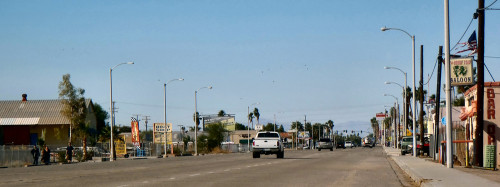
I was back on the road again by 8:30 and in the town of Blythe by late morning. I cruised the main east-west route through town, past palm trees, tire shops, taverns and fast-food joints. I had a hot lunch and refilled my bottles, then relaxed in the shade to watch the world go by and consider how I’d be spending the rest of my day. I had ridden as far south as I had intended, and was now looking forward to spending the next few days slowly riding back to the north. I’d be passing through some wide-open valleys along quiet backroads, and I fully expected to be very much on my own.
I rode north out of town along a minor paved route called the Rice-Midland Road. The tailwind that had done such a nice job of pushing me south was now in my face and, though it wasn’t too strong, made the going a bit slower. To make matters worse, I found I was climbing as well, though the slope, like much of the open terrain here in the Mojave, was rather gentle. The paved surface of the road turned to graded dirt a few miles north of town, and I spent the bulk of my afternoon climbing steadily toward a minor pass along the foothills of the Big Maria Mountains.
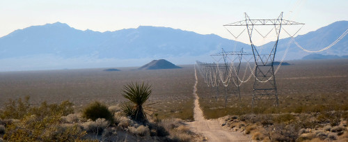
A powerline road north of Goffs, California. Photo by John Roberson
At the pass I had an expansive view to the north of Rice Valley and far-off desert ranges. The sun was low in the western
sky, and I knew my second riding day would be ending soon. That was OK with me. Over the years I’ve come to relish those transitional times of the day: the peaceful early mornings and evenings, when the air is still, and the sun’s rays are less harsh and cast the longest shadows. The desert’s critters are more active, too, and the roads become less busy as folks finish getting to or from work. I was thoroughly enjoying the scene as I rode into the southern reaches of Rice Valley. Distant ranges were sharp-edged profiles on the horizon and, other than the rail lines that crisscross the open valleys here, and the occasional mine, I had the place to all to myself.
On the Rice-Midland Road near sunset. Photo by John Roberson
My maps showed me that I was riding through the Rice Valley Wilderness area and a roadside sign also made that clear. The sign informed “motorists and bicyclists” that the road formed the wilderness boundary, and that we should stay within 100 feet of the road. As I lost the sun I made my way off the roadway along a patch of hard-surfaced desert pavement (leaving no tracks in the process) to another cozy camp spot.
Fenner, California. Photo by John Roberson
The winds of the afternoon had moderated nicely as I set up for the evening. I spread out my groundsheet and off-loaded my panniers and pads and literally settled down for the evening. Like any responsible traveler, I like to keep my footprint to a minimum, so I try to limit my camp activities to the edges of my groundsheet (about 5′ x 7′). I sit and stretch on a couple of pads as I do my chores. Everything I need is within easy reach, and I try to orient myself to the best views of my surroundings. I’ll set up a tarp shelter if the weather warrants it, but I’ve yet to do that on any of my previous Mojave trips, and the clear skies of that particular evening left me confident that I’d be treated to another dry, star-filled night. The temperature had dropped pretty quickly as the sun set, so I pulled out my cool weather clothing, unstuffed my sleeping bag, and got comfortable. As
On a powerline road near the end of the day. Photo by John Roberson
I got the stove going for my supper, a couple of ravens circled over my camp, checking me out and encouraging me, I thought, to relax and enjoy another lovely Mojave evening.
Day Three
I slept like the proverbial log and was ready to go by the time the sun had had a chance to warm the morning air. I loaded up and continued riding north on the Rice-Midland Road, enjoying the solitude and taking in the beautiful scenery. I hadn’t seen a soul since the middle of the previous afternoon, and I was pretty sure I’d have the road to myself until I got a little closer to the next paved road, which was about 12 miles further to the north. This particular patch of road was well graded, and I made good time. I arrived at the rail crossing of Rice around noon, then rode west along paved Route 62 for a few miles before turning north again onto the Cadiz Road.
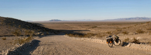
The Cadiz Road is a graded road that runs north and south for about 50 miles. I’d traveled this way on an earlier trip and was taken by the expansive beauty of the scenery and the fairly easy riding conditions. The road passes through wide, open valleys, and past dry lake beds, and it skirts the edges of a couple wilderness areas. It was also a fairly direct route to my next known water supply source, and it ran roughly parallel to one of the Mojave’s many rail lines.
I spent the afternoon riding north without seeing another vehicle. A few birds flitted here and there in the sparse vegetation, mostly creosote and ocotillo, and I encountered a few, slow-moving tarantulas at the edges of the road. A single freight train lumbered by late in the afternoon, though the tracks were far enough away from the road that I heard only the softest rumble as it made its way north. The winds of the previous days had mellowed considerably, and I relished being able to hear the sounds of the surrounding desert and the crunching of my tires as I negotiated the varying surface conditions. I made decent progress, and I was generally able to find clean lines of travel as I navigated the roadway. But I still had to dismount fairly often when I came to the sandy bogs that are characteristic of the Mojave desert roads that cross the wide valleys. It seemed to me that the road was overdue for a visit by a county grader. I spent the remainder of the day moseying along at an easy pace, stopping for the occasional bog or roadside curiosity, and by the time the sun had settled below the horizon (around 6:30, Cali time), I was setting up another restful camp.
Day Four
By the time the first rays of the sun hit my camp the following morning my oatmeal was quietly reconstituting in the foot of my sleeping bag, and I was working on my second cup of java. The nighttime temps had dropped into the low 30’s, but I slept warmly and deeply, and I knew the sun’s rays would bring up the temps before too long. As I went through my morning chores I thought a bit about my situation. I hadn’t had the opportunity to replenish my water supply since leaving Blythe, but I knew I could manage another night out before water became a problem for me. There aren’t many opportunities to water-up here in the Mojave. There are none of the livestock troughs and irrigation canals and springs that one can often find in the Great Basin deserts. My maps show the occasional well or spring, usually up in the low mountain ranges, but I hadn’t considered them in the past. I always carry a water filter, but I had yet to encounter any open water sources along my route. I knew I could count on water at Fenner, a gas station and oasis along I-40, another 40 miles up the road, but I still had another 20 miles of dicey conditions on the Cadiz Road before I could take advantage of the nearest pavement. Fortunately, the cool December days meant my needs weren’t as acute as they might be at other times of the year. So, with my sights set on distant Fenner, I headed out onto the road once again.
The day was as beautiful as could be, but an early-morning breeze had become something with a bit more kick to it, and I found myself fighting a headwind along with increasingly challenging road conditions. There were frequent, sandy stretches and a place or two where the road had been severely damaged by flash floods. I was on and off the bike every few minutes or so. It was not the best way to make progress, for sure. The winds had kicked up a fair amount of dust, too, and I found I had to hunker down now and then to sit out an especially abrasive blast. After a few hours of these conditions, I finally hit U.S. 66 at the Cadiz railroad crossing. However, I was well into the afternoon by this time and all but certain not to make Fenner by the end of my day. It was time for Plan B.
I spent the last hour or so riding easily northeast on Route 66. During that time no more than a half dozen cars passed me by. It was, after all, Christmas Day, and I assumed nearly everyone with any sense was at home, taking it easy with family and friends. I was pretty sure that traffic would pick up the next day, so I was relishing the remarkably quiet riding conditions.
I ran out of light along the highway as it passed through Fenner Valley, along the southern slopes of the Clipper Mountain Wilderness. I left the highway and climbed up a gentle slope for a few hundred meters, pushing my bike over some firmly-established desert pavement that showed no signs of my passing. I picked a spot well away from the “busy” highway and settled in for my fourth evening in the desert.
Beautiful downtown Blythe, California. Photo by John Roberson
Day Five
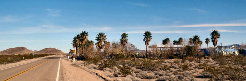
After another incredibly restful night’s sleep I was back on the highway the next morning with about a half -liter of water to my name. Despite my dwindling water supplies, I was comfortably hydrated and ready to go. A couple of hours later, after a mellow ride along the still-quiet highway, I found myself rolling into the formerly-active railroad community and “oasis” of Fenner, California.
Fenner really looks like a true desert oasis. There are statuesque palm trees waving in the breeze and a collection of somewhat shabby concrete pools and fountains that tell of a reliable source of natural water. There is a gas station at Fenner, and a well-equipped convenience store to serve the needs of the folks on I-40. I filled my bottles, munched a few treats, and watched assorted birds and motorists drawn to the sights and sounds of the pools of water, much as anyone traveling in the deserts might be tempted to do.
I rode north and east from Fenner on a paved highway that leads to the town of Goffs, about ten miles down the road. Goffs is a quiet place located on the southern edge of the Mojave Natural Preserve and a great place to get a feel for what life in the Mojave desert regions is really like. Though there are no commercial conveniences to speak of, there is a wonderful museum and a collection of restored buildings (closed for the holidays when I passed through) and assorted desert “junk” from bygone days. The town lies on the railroad and was a bustling military outpost during the second World War. I’ve passed through Goffs a few times on past trips and have always found the few folks I’ve encountered to be very welcoming and enthusiastic about their community and the Mojave region in general.
I left Goffs and rode east on paved road, around the north end of the Piute Mountains, and adjacent to a very busy stretch of rail line. Every half hour or so a freight train would rumble by with its load of containers on its way to Needles to the east, or west to the Pacific coast. The highway itself was very quiet. Most vehicle traffic seemed to be using I-40, which runs parallel to the Goffs road about five miles further south.
As I rode, I was increasingly aware that my trip was nearing its end, and my riding was necessarily taking me in the general direction of Needles. My truck was still a day’s ride away, but I had a few options about getting there. I could continue on the road I was using until it met up with U.S. 95, a few miles further east, and then south to a point where it intersects with I-40. A ten-mile, downhill run along the interstate would then take me directly into Needles again. I’d taken this route a few times before. It was a relatively quick run, but the noise and traffic intensify the closer one gets to Needles. Since I still had plenty of time, I decided to stick to the back roads and try a new route that would take me over the Sacramento Mountains to an eventual intersection with the road I’d used to leave Needles five days earlier.
I left the Goffs Road about five miles east of town and rode south along one of the many powerline roads that crisscross the valleys of the Mojave. The roads aren’t paved, but they are well-maintained, and I knew this particular stretch would carry me many miles south to a point where the backroad I was searching for climbs over the mountains to Needles. I passed a power tower every couple of minutes, and the soft hum of the wires gave an extra flavor to the gentle breezes I’d been enjoying all day. At one point on the road I stopped to check out an intriguing white object off in the distance and discovered the dessicated shell of a desert tortoise.
I crossed I-40 for the second time that day, marveling at the sheer intensity of the traffic zooming by, and continued southeast along another powerline road. I was truly enjoying the peace and solitude, and the wonderfully easy cruising conditions, but once again, my short riding day was coming to a close. The rumble of the earlier trains was far behind me, and the freeway was no more than a string of slow-moving lights in the distance as I began looking for a pretty place to hunker down for one last night in the desert. I left the road and slowly picked my way along a sparsely vegetated drainage zone to another open camping spot, and settled in for one last, peaceful evening.
On Route 66, west of Fenner. Photo by John Roberson
Day Six
My last day started much the same way as the others with a pre-dawn coffee fix and a hearty bowl of oats as the sun rose to warm the morning. My load was pretty light at this point in my journey – a good 25 pounds lighter than when I began – and I made good progress as I continued down the powerline road. I found the backroad turnoff I was searching for and headed east.
The road appeared to run parallel to a pipeline of some kind, and I found the going to be great for a few miles. The road was quiet, fairly level and well-maintained, but it began to rise and fall with increased seriousness as it passed through the foothills of the Sacramento Mountains. The road ignored the contours of the terrain and insisted on following the straight line of the pipe. There was a lot of up and down riding. It was the most challenging riding of the week, and I spent a good bit of the morning pushing my load up and down a few insanely steep pitches. Eventually, I encountered U.S. 95 again, with its smooth, gentle grade. I checked for traffic, mounted up one last time, then rolled easily back down the highway to Needles, my truck, and the long haul back home.
Nuts and Bolts
My Bike – I rode a mountain bike with a lugged-steel frame, made by the folks at Rivendell. I used beach-cruiser tires on 26″ wheels, and I carried front and rear panniers. I also carried a few basic tools and spare tubes (no flats on this, or any other Mojave trip!).
Special Gear/Clothing – I always carry a lightweight tarp-sLuxuries! – I carried a minimalist Thermarest pad to supplement an old, closed-cell foam pad. I had tunes in the helter (which I have yet to use in the Mojave). I carried a dependable, cool-weather sleeping bag, and bivy sack. I had wool shirts and a sweater, cargo shorts and a pair of windproof pants, Nanopuff insulation, hats and gloves, warm socks and comfortable shoes. I was always very comfortable.evening from an old mp3 player and a tiny speaker. I used a handful of tiny, battery-powered lights that gave my evening camps a soft, lovely light. I carried a small camera, and I had a small phone to keep in touch with home.
Weather – I experienced mellow, mostly sunny days with daytime temps in the 50s and 60s and the 20s and 30s at night. There were occasional clouds, no rain, variable winds, and consistently great sunsets and sunrises. The night skies are wonderful!
Trip Statistics – I covered about 300 miles on a mix of paved and dirt roads. I had no mechanical or physical problems, but there seemed to be more wind and dust than on past trips. My bike and load weighed 92 pounds at the onset, and twenty-five pounds less at the end.
Maps – I used the California (and Nevada) Road and Recreation Atlas from Benchmark Maps. Like all of the atlases in the series, they are reliable and very easy to read. I take only those pages I think I’ll need, and I usually fill them with notes.
Cycling West and Cycling Utah Magazine’s Winter 2017 Issue is now available as a free download (9mb download), Pick up a copy at your favorite Utah, Idaho, Wyoming, Nevada, Montana, W. Colorado, N. Arizona bike shop or other location!
Cycling West Winter 2017-2018 Cover Photo: Niki Tichhauser on the Jolly Green Giants Trail at Grand Targhee Resort in Wyoming on January 21, 2017. Photo by Jeff Buydos, courtesy Grand Targhee Resort.
Contents
Keegan Swenson is Cycling Utah’s Rider of the Year – page – 3
Cycling West and Cycling Utah Celebrate 25 Years! – page – 3
Troy Adair Mixes Public Transit and Biking to Get to Work and to the Trail – page – 4
Book Review: You & A Bike & A Road – page – 6
Take Care of Your Knees for Happy Cycling – page – 7
Southern Accents – page – 8
Preparing Your Bike for Winter – page – 9
New Pathways and Trails Coming to Utah, Idaho, Montana, and Wyoming – page – 10
Book Review: Sue Knaup’s Bike Hunt: A Memoir Tells Stories of Giving Away Bikes – page – 10
Tarantula Ride…And More – page – 11
Mountain Biking in Thailand – page – 16
2018 Sedona Mountain Bike Festival Set for Fun and Trail Fundraising – page – 18
An Ode to Beer – page – 19
Applequist and Stevenson Show ‘Panache’ Winning LoToJa 2017 – page – 20
Push, But Not Too Hard – page – 22
New Regional Bike Friendly Communities Awarded page – 22
Healthy, Happy Holidays: A Nutrition Survival Guide for Endurance Athletes – page – 23
SLCBAC News for Winter 2017 – page – 23
Report: Bike Lanes Reduce Injuries – page – 30
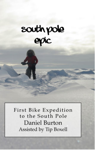
A Review of “South Pole Epic” by Daniel Burton – page – 30
Riding in the Mojave: Cibola Roll-a – page – 31
Fire, Water, and Summer: Bike Touring North Central Idaho – page – 32
Take the Bus; Go on a Bike Tour; Salt Lake Express, Your Bike Touring Buddy – page – 34
Bike Utah: Reflecting on 2017: Where we are and where we need to go – page – 35
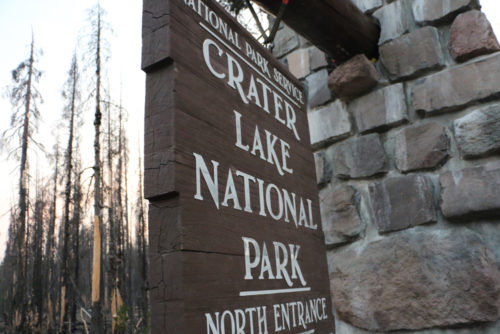
The entrance to Crater Lake National Park. How much will National Park fees rise under current plans? How will they affect bicycle touring cyclists. Photo by Dave Iltis
Guest Editorial by Lou Melini
Before my retirement, I received about $960 in total during 4 years I was able to take advantage of the Bicycle Commuter Act. In the Senate version of the tax bill, cyclists will see the meager $20/month Bicycle Commuter Tax break eliminated. Bus riders and car drivers will still see their $255 tax break remain intact. An article from the Washington Post quotes Ken McLeod, policy director at the League of American Bicyclists stated that cyclists are interpreting the purpose of pulling the tax break simply to send a discouraging message to cyclists. He further stated that the tax benefit costs the government about $5 million/year but is unsure how many cyclists the program benefits. CityLab summarized the Post article using the word “spite”. PeopleforBikes is also encouraging cyclists to contact their representative to restore the Bicycle Commuter Act.
Touring Cyclists will also see a boost in fees if they visit select National Parks during “peak season”. Yellowstone NP currently charges $15 for entering the park by bike (or foot). This fee will go up to $30 if the National Park Service (NPS) enacts the fee increase. Automobile entrance will also go up from the current $30 fee to $70 at Yellowstone. Personally I know the National Parks need the money. I sometimes think I should not use my senior pass that allows free entrance to the Park (that also includes my wife entering for free). I contribute to the National Parks Foundation (NPF) and to Yellowstone Forever as a way to help the Parks. (The NPF supports the fee increase according to the Washington Post)
National Park entrance fees are good for 7 days, so one could go to 2 national parks (Yellowstone and Teton for example) with one entrance fee. If 4 people are packed into a car, the per-person fee is actually quite small. Compare the Park fees with Disney World charges a minimum of $60/person per day with fees going upward to $130.
I am in favor of a fee increase but I would like the increase smaller and fairer to cyclists. Think about 4 people in a car paying $70 vs. 4 cyclists arriving and paying $120. This doesn’t seem right to me. Now if the NPS tells me that 80% of the cars coming to Yellowstone only have 1 or 2 passengers then I will back off with my complaint.
However I am a bike guy and I think the proposed bike fee for entering Yellowstone should be no higher than 25% of the car fee and that was my comment to the NPS. If you want to weigh in on the propose fee increase go to: https://www.nps.gov/orgs/1207/10-24-2017-fee-changes-proposal.htm
Anyone who knows me knows that I have done some epic things. But Mr. Burton has taken it to another level far beyond. Who decides to bike to the South Pole? With absolutely no experience camping in winter. At least he had the sense to do it in the southern summer. Still, I am absolutely amazed that through stubbornness and audacious tenacity he actually made it there. Kudos.
“Cold, uphill, 20-30 mph headwind in the snow. It was the definitely hardest day of my life, again.” I can’t help but laugh at the monstrosity of the man’s dream. He went from sea level to 9300 feet. Basically in the middle of winter, although it was “summer; down there. Carrying and pulling sleds with all his food and gear. Or mostly pushing it on foot at times.
A few anecdotes: “I think I have a sleeping disorder. Whenever I sit still for a few minutes I will fall asleep.” Sound familiar after a really long, hard ride?
And then his freehub went out, again. “I wired the cassette to the spokes…” In the middle of Antarctica. But he managed to fix it enough to keep going as long as he was careful with it. And he was in a personal race with Juan Granados, who claimed to be riding but Burton was following his ski tracks, not bike tracks.
After riding through everything, from Dec. 2, 2013 to Jan. 21, 2014, he made it. From his blog: “I’M AT THE SOUTH POLE!!!!” And “It is COLD here!”
The best part is that Daniel is one of us. He was a computer programmer for 23 years here in Utah, and after getting laid off he founded Epic Biking in Saratoga Springs on the west side of Utah Lake. Biking had gotten into his blood, like it does with a lot of us. And then he took a few thousands steps farther. Well done.
It is quite a read. Using a combination of notes from a journal and writing from remembrance, this tough trip comes through loud and clear. Well worth the time, and will bring back memories of long, hard rides of your own.
Thank you for the support that made it possible for us to publish for so long. We are honored to be part of the bike community.
Cycling West and Cycling Utah is proud to have completed 25 years of bringing you news and information on cycling in the Intermountain West. Founded in 1993 as Cycling Utah by David Ward and Bob Truelsen, the legacy of their creation continues. In 2016, we became Cycling West in the region, while keeping the name Cycling Utah in the Beehive State.
The Winter 2017 issue is our 199th edition. We have published 8 times a year, except in 2002 when due to the Olympics, we ran 7 issues.
Our mission with Cycling West is to grow, connect, and inform the cycling community by providing great content and resources for cyclists, athletes, and bike shops. Over the winter, and in the next year, look for more great coverage, new programs, new opportunities to contribute cycling news and stories, and new ways to sponsor and support Cycling West and Cycling Utah.
We look forward to being part of the community for another 25 years!
Find a copy of the latest issue in your favorite bike shop in Utah, Nevada, Wyoming, Idaho, Montana, W. Colorado, N. Arizona, and N. California.


 Anyone who knows me knows that I have done some epic things. But Mr. Burton has taken it to another level far beyond. Who decides to bike to the South Pole? With absolutely no experience camping in winter. At least he had the sense to do it in the southern summer. Still, I am absolutely amazed that through stubbornness and audacious tenacity he actually made it there. Kudos.