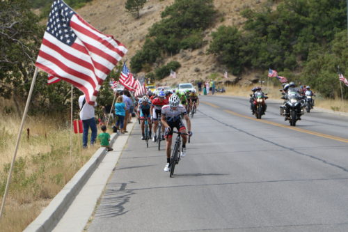
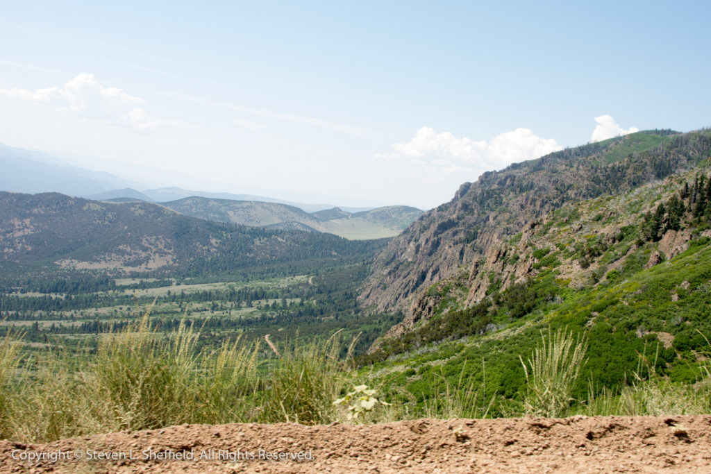
The Bountiful Bench was lined with American flags on stage 5 of the 2016 Tour of Utah. The stage will be featured again this year (Stage 5 – August 4, 2017) Photo by Dave Iltis
By David Ward
Tour of Utah
Let the climbing begin. You saw the excellent, detailed Spectator’s Guide in the July 2017 issue of cycling utah/cycling west. This year’s Tour of Utah challenges more than 120 international professional cyclists with over 36,000 feet of climbing in one short week. I am really stoked about this year’s venues. Without re-plowing ground covered in the Spectator’s Guide, let me hit a few of the highlights I am excited about.
Stage 1 begins the Tour with a long slog up Logan Canyon, around Bear Lake and then back to Logan. The section that will really hurt their legs is the return climb, after looping around Bear Lake, from Garden City to the top of Logan Canyon. I have done this several times, and it is a leg-burner. This is certain to be where the main and final attacks come, and will be a great place to take in a part of this day’s stage.
An individual time trial up Big Cottonwood Canyon for Stage 3 will tax the legs of each racer. Beginning at the Donut Falls Trailhead, it will climb 6 miles, finally ending at the Brighton Ski Resort. Just before the finish is a short, steep pitch that will burn the quads as each racer finishes his ride. This short section is where one should be to take in the finale to this stage.
Stage 6, the Tour’s Queen Stage, is a parcours beginning in Soldier Hollow near Heber City, traces its route around Deer Creek Reservoir and part way down Provo Canyon to the turn off to Sundance Ski Resort. From there, it climbs past Sundance and over the top of the Alpine Loop before dropping back down to the valley floor where it winds its way to the base of Little Cottonwood Canyon for the final 6 mile climb to the Snowbird Ski Resort. Assuming there are still two or more riders battling for the overall title, this is where the race will be decided. The final attacks should come in the Seven Sisters section, the final steep pitch just before Tanner’s Flat.
And for good, fast and technical racing, and excellent spectating, nothing beats Stage 7’s circuit race looping 6.8 miles through Salt Lake City. Watch the racers suffer up the steep incline on North State Street to the Utah State Capitol, or watch the racers fly, and the officials’ and support vehicles screech, around the turns at Reservoir Park. Or do both.
Thrilling racing, coupled with the Harmon’s Healthy Living Expo and University of Utah Kids Sprint to the Finish Line featured on each stage, make for a complete week of spectator excitement at and participation in this year’s Tour of Utah. Pick your stages, and be there for a fun and exciting time.
Arnold Jones is running for Salt Lake City Council in District 1 in 2017.
Arnold Jones’s Answers to Salt Lake City 2017 City Council Election Candidate Questionnaire on Bicycling
Background: Cycling is a healthy and fun form of transportation and recreation that improves livability, health, and economy in Salt Lake City. We ask these questions to provide information to Salt Lake City’s citizens regarding your outlook on cycling. We will publish the answers on CyclingUtah.com as we receive them.
Candidate Information: Please provide your name, contact info for your campaign, council district (describe too) and if you like, a brief statement regarding your candidacy.
My name is Arnold Jones. I am running for District 1 (rose park area) city council.
Contact information: Arnold Jones election committee, 1250 n Oakley st, slc, ut 84116
As a candidate running against the current incumbent “ James Rogers” I believe he has done a very good job as the current incumbent. I feel that I have a lot to offer as a long standing resident of the Rose Park area and am aware of needed issues that need to be addressed in regards to District 1. I will work dutifully to represent the residents of my district as well as a team member in relation to working with all of the council members as there are many issues that affect not only our community but also Salt Lake City as a whole.
Council Candidate Questions:
What is your vision for cycling (both road and mountain biking) in Salt Lake City? What
would you do to make that vision happen (planning, budget, infrastructure, education,
safety, economy, etc.)?
Answer: My vision for cycling both road and mountain biking in the salt lake city area would be to have more bikes available to our citizens within the city. It is a clean and healthy way of transportation. Does it work for everyone, the simple answer is no. Could it work for a lot of people, Yes.
I would like to see each of the neighborhoods have two bicycle station areas where people are able to pick up bicycles and drop them off at. I think that the current plan is only addressing recreational usage. Many people do not have the funds necessary to purchase quality bikes. This is one area that should be addressed. This is one area I would address as individuals use bicycles for various reasons.
As for mountain biking, this is a great exercise and also a sport. However, the majority of bicyclists are city riders using the Jordan trail and local streets.
More education is needed. It needs to be refined and then pointed towards each specific group. Like, children, elderly, families, etc.
Budgeting, this is a larger issue. New bikes, maintenance of bikes, charging of fees to use bikes or not. A lot needs to be considered here. The reason is that even though this is a positive method of having some small impact on street congestion, minimal effects on city pollution, revenue generation to help offset costs, etc. This really is a negative monetary generating option at this point and more than likely into the future.
I believe it is a worthwhile project and one I support, the real answer is two folded. Can the city budget include this and be able to realize it will be a revenue losing issue.
2. What is the biggest issue for cyclists currently in Salt Lake City and what will you do to
address it?
Answer: I covered this part in question one. There is a lot that needs to be researched and discussed and then brought up for consideration. This also includes the current enacted salt lake city recreational cycling plan and revising it appropriately.
3. What would you like to see in your district in regards to bicycling?
Answer: here in rose park district 1 area. Our community is primarily made up of working aged adults and families. We also have a large elderly population. I would like to see several locations were bicycles are available for our residents to utilize for riding and also through retailers offer a discount and/or possibly a city subsidized purchase program as many of our community residents, like other community residents, have limited income when it comes to purchasing and maintaining appropriate bicycles for their age groups and needed exercise levels. Is this an end all solution, of course not.
4. In your district, the following is an issue for cyclists: The Marmalade, Fairpark, and Rose
Park area have some great spots for cycling, but the crossing of I-15 and other areas need
vast improvement. What are your thoughts on our Proposal for Better Bicycling in the area:
What are your thoughts on this and what would you do on the Council to address it?
Answer: First one fallacy I see in the plan is: by having bicycling lanes added in certain areas, which is much needed, do not slow down traffic speeds. This I have noticed as both living in and driving in as well as bicycling in is not correct. People need to be aware of bicyclists and pay attention to them as they have at times the right of way. Bicyclists also need to be aware of vehicles and ride in safe manners, Which I see as not happening as well. This is a two-folded issue as many other issues are.
As for adding bicycling lanes. This needs to be done and I feel that adding in a curbed area that helps in aiding for bicyclists safety. This is costly as well and needs to be addressed. However, I feel this is a necessity.
5. Also in your district, the Northwest Quadrant is being developed. The I-80 Frontage Road is
one of the best cycling routes in the Salt Lake Valley, but is under pressure from the new
development. What are your thoughts on this and what would you do on the Council to
address it?
Answer: I believe that part of the answer was addressed in answering question 4. I also believe that more appropriate research needs to be done on the issue. However, it needs to be included in the redevelopment plan.
6. What cycling initiatives would you bring to the Council?
Answer: I would like to find a way to implement some of the above answers through the council. I am aware that not everything will be approved. However, it needs to be considered. There are many additional ways of improving the current plan. However, this is not going to be an instant improvement and will need to be continuously addressed, revamped and improved. Not only through budgetary allocations but also through choices that help assist in healthy improvements to our community members but also viability of being able to purchase and use bicycles in all of our districts. Continuous plans to improve the plan needs to ensure it helps with all of the districts and not just favor one or two primarily. Otherwise, this will never move forward through the council and even reach the consideration and approval of the mayor’s office.
7. Would you favor strengthening the Complete Streets Ordinance? If so, how?
Answer: Overall, I would support this policy. However, there are some changes that need to be done to it and it needs to be brought to the forefront and find a way to begin implanting it.
8. Regarding the proposal 10,000 Wheels for Affordable Transportation, what are your
Answer: I think this is to broad of a implementation program to start with. It is a great idea. There are way to many issues to be covered initially as well as be able to get approval of budgeting. This needs a lot of stream lining and done in realistic setting of agendas and goals. Otherwise this is a futile plan and never get final approval.
I believe in having a committee to study this and suggest initial ways of realistic attaining this objective. Once this is done then considering a budget that is realistic and possibly attainable. Once this is completed then the bringing in of the officials listed would be appropriate for final consideration at each step of the program.
9. Regarding the proposal for a comprehensive recreational cycling plan for Salt Lake City, what are your thoughts and would you commit to working to implement this proposal if you are elected? (https://www.cyclingwest.com/advocacy/a-proposal- for-a- salt-lake- city-recreational-cycling- plan/)
Answer: yes I would be supportive of this plan and work towards the goals listed in the above answer.
10. The 2015 Bicycle and Pedestrian Master Plan was passed by the Council in 2015. What will you do to ensure its implementation?
Answer: I would suggest relooking at the plan and making necessary changes that I have suggested above and then take into consideration of the other council members suggestions as well as community input that would be needed.
11. Do you ride a bicycle? Tell us more about how and where you ride.
Answer: yes at various times I do ride a bicycle with my family and this is mostly done in the rose park area. I use it to go to the library, grocery store and just plain exercise.
12. Is there anything else you would like to add?
Answer: I feel that I have given a lot of feedback to this point in my above listed answers. This is not an end all solution and needs everyone’s consideration as stated above from community members and council members as well as retailers input. This issue affects everyone as a whole.
Laura Cushman is running for Salt Lake City Council in District 3 in 2017.
Laura Cushman’s Answers to Salt Lake City 2017 City Council Election Candidate Questionnaire on Bicycling
Candidate Information: Please provide your name, contact info for your campaign, council district (describe too) and if you like, a brief statement regarding your candidacy.
Survey Answers: Laura Cushman, City Council Candidate for District 3
1. What is your vision for cycling (both road and mountain biking) in Salt Lake City? What would you do to make that vision happen (planning, budget, infrastructure, education, safety, economy, etc.)?
It is my vision that Salt Lake City become a city where anyone who wants to commute or recreate on their bicycle could do so, and do so with minimal concern for safety. In regards to road cycling, I would like to see the Bicycle and Pedestrian Master Plan implemented on an accelerated timeline that begins immediately to improve the road surfaces and safety of all cyclists. While the city has been adding bike lanes, there are still many gaps between routes that need to be addressed, especially those closest to major mass transit stops, and in the western portion of our city. Additionally, long distance bike commuters and those who recreate on the Jordan River Parkway Trail would benefit greatly from a major east-west bike pathway to act as a connector for residents who live closer to the foothills. Regular maintenance to road surfaces traveled on by cyclists to repair potholes needs to be a priority. Additionally, regular street sweeping of bike lanes in order to clear debris that can also cause accidents, as well as flat-tires, should be scheduled. I would like to see the city take an active role in cycling outreach towards individuals, as well as businesses, to promote the benefits of a comprehensive city plan that embraces and incorporates cycling. These include, but are not limited to, improved health, zero emissions and economic growth.
The trail access in Salt Lake City is one of our greatest assets and should be fiercely protected. As a hiker, runner and occasional mountain biker, I have experienced some frustrations with the current system of trails. I think we need to look at shared-trail options, as well as directional trail plans that limit congestion and promote safety for all trail-users on and off bikes. Kiosks and maps at trail heads with information are helpful and can serve as a reminder of trail etiquette including rights of way and limited headphone use.
These improvements cost money, and therefore it is important that we have a voice in the city that will advocate for appropriating funds for the master plan and other related initiatives sooner rather than later.
2. What is the biggest issue for cyclists currently in Salt Lake City and what will you do to address it?
Recent studies, as well as conversations I have had with residents, indicate that safety on bikes is the primary concern. UTA recently reported that 60% of individuals questioned have an interest in riding bikes, but they are concerned with their safety while riding. Well-identified and continuous bikes lanes are where we should start. At a minimum, striping that creates a visual boundary for cyclists and drivers should be added or enhanced. When possible, physical barriers add to a rider’s perceived level of safety and should also be considered. Clean and level road surfaces also make rider’s feel safer. Citywide outreach that advocates for the rights of cyclists and identifies how to be a more mindful driver, will also make riders feel better in their decision to ride.
Another issue that I commonly hear is that the hilly terrain in SLC is intimidating. Investing in signage that indicates different route options can help direct individuals to routes with an appropriate level of difficulty. Also, I would like to see an app developed specifically for SLC that would assist riders in finding direct routes with the least severe inclines.
3. What would you like to see in your district in regards to bicycling?
More bike lanes! On a grand, fantastical level, I imagine a magic carpet that would assist cyclists with some of the steep grades we face in District 3. I don’t see this as a realistic option, but hey, I can dream! On a more feasible level, I would like to bring Green Bike Share further into District 3. Specifically, I would like to see kiosks placed that allow for connectivity between the lower western to eastern avenues. By doing so, a larger number of district 3 residents would have another option for commuting downtown, outside of their cars. Possible locations include nearby the Smith’s gas station on South Temple or near Publik Coffeehouse at 3rd and G. Let’s not forget about Marmalade! A bike share at or near the new library would be huge in connecting these D3 residents to downtown. Also, one near West High School may create additional commuting options for students. These options are within (or very close to) the requisite distance between kiosks, and would be a great branching off point for future placement.
4. In your district, the following is an issue for cyclists: The Marmalade, Fairpark, and Rose Park area have some great spots for cycling, but the crossing of I-15 and other areas need vast improvement. What are your thoughts on our Proposal for Better Bicycling in the area: https://www.cyclingwest.com/advocacy/road-advocacy/proposal-better-bicycling-marmalade-rose-park-fair-park-area-salt-lake-city/
What are your thoughts on this and what would you do on the Council to address it?
I think this is a wonderful plan, and would be a great addition to the district! These are areas of the district and the city that have shoddy access to mass transit AND are seeing a lot of growth. Implementing projects that increase walk and bike-ability within these neighborhoods, as well as connecting them to other areas of the city is crucial. Having ridden over 600 N, I’m not sure there is any sketch within its current existence that would make me feel more comfortable…! The proposed bridge at 300 N will be a good alternative option for some riders. Ideally, I would like to see a protected 2-way bike path that allows bikers to cross on the existing structure while providing a barrier to cars. In order to do this, there would also need to be updates made on either side, in order to properly merge bike traffic onto these safer, protected bike lanes. We are seeing a lot of residential growth in these areas and any cycling infrastructure we can begin now, will assist current residents, and could even be a draw for new people looking to live somewhere with a well-laid out and FLAT bike route to and from work. As a city council member, I will fight hard for initiatives like this one so they are a priority, as they reflect our city’s commitment to sustainability and clean air.
5. What cycling initiatives would you bring to the Council?
As mentioned above, I want to work with Green Bike Share to extend access to more SLC residents. I also want to work closely with UTA in order to identify active zones nearby stops and platforms where the city can improve connectivity for commuters. I love the idea of the Hive Pass, and will work hard to develop similar programs that promote UTA ridership and active transportation. I also want to see a commitment to cycling outreach and promotion. Specifically, I’d like to see the city become more vocal in discussing the benefits of cycling and partnering with large businesses within the city to discuss methods/proposals that incentivize employees to opt out of their cars. Seasonally, I would propose a partnership with Cycling Utah that selects areas of the city one day each month during the summer where selected streets are blocked off so individuals and their families could enjoy riding on streets with other Utahns and share the joy of riding.
As a resident who has spent the majority of her adult life without a car, I am extremely committed to the complete street ordinance. Personally, I have experienced firsthand the health benefits of active transportation, as well as the positive feelings that come with knowing I have made a good decision for our environment. Additionally, increasing walk and bike-ability in neighborhoods has been shown to have a positive impact on businesses. As a long-time cyclist and active transportation advocate, I will be the on-the-ground voice that fights to ensure street projects are in line with CSO, and speak to how this commitment can have a positive effect on our city. For example, the impact costs associated with projects and the jobs created are a boost to our economy.
Absolutely! I love this proposal for the reason that it encompasses so many of the active, environmental and social values that are most important to me. For this reason, I will fight tirelessly to see the items within this initiative become a reality.
Recreation is one of the biggest reasons people come to SLC and an even bigger reason for why they decide to stay. Having well-connected roads/pathways/trails, detailed maps, consistent signage and info kiosk are hugely important to those who recreate on bikes and/or by foot. It is not only important for those who live here, but also for those who visit. Recreation cannot be overlooked as it relates to tourism in SLC. For that reason, comprehensive trail plans with the items listed in this proposal are sure to elevate the trail experience and further distinguish our city as a mecca for outdoor enthusiasts.
9. The 2015 Bicycle and Pedestrian Master Plan was passed by the Council in 2015. What will you do to ensure its implementation?
I will advocate tirelessly for the Bicycle and Pedestrian Master Plan, and my initial focus will be on accelerating the timeline and increasing the budget for its successful implementation. There is a strong connection between active transportation and air quality, and therefore, if we are going to commit to cleaner air, then we need to commit to infrastructure improvements that can have a direct impact on its status.
10. Do you ride a bicycle? Tell us more about how and where you ride.
Yes- all the time! I am an avid cyclist who both commutes and recreates on a bike. I will admit, having children makes it challenging, but whenever possible, I commute by foot or on my bike. Most of my commuting routes revolve around the Avenues, the Jewish Community Center/University and downtown, though I’ll ride my bike anywhere. Cycling is one of my favorite forms of exercise and you will often see me riding up City Creek Canyon, Little Mountain or Big Mountain. I grew up in the Midwest, and I pinch myself every day that the Wasatch is my backyard.
11. Is there anything else you would like to add?
Biking is a huge part of my life, and my husband (who I met on a bike ride) and I work hard to instill in our children that driving is not the only option. We are a family of five committed to cycling, with our bikes outnumbering our car 14 to 1.
George Chapman is running for Salt Lake City Council in District 5 in 2017.
Salt Lake City 2017 City Council Election Candidate Questionnaire on Bicycling in Salt Lake City for Cycling Utah
Background: Cycling is a healthy and fun form of transportation and recreation that improves livability, health, and economy in Salt Lake City. We ask these questions to provide information to Salt Lake City’s citizens regarding your outlook on cycling. We will publish the answers on CyclingUtah.com as we receive them.
Candidate Information: Please provide your name, contact info for your campaign, council district (describe too) and if you like, a brief statement regarding your candidacy.
STOP ROAD DIETS THAT INCREASE CONGESTION AND POLLUTION
STOP WASTING MILLIONS ON ALLEY TRAILS
REQUIRE SL COUNTY TO LOCK UP AND PROSECUTE DRUG DEALERS
PROTECT WATERSHED AND BUILD CANYON RESTROOMS
RESTORE BETTER NEIGHBORHOOD BUS SERVICE
SOLVE PROBLEMS NOW INSTEAD OF WAITING UNTIL ELECTION TIME
RETIRED ENGINEER, VETERAN, OPED WRITER, COMMUNITY ACTIVIST
Council Candidate Questions:
What is your vision for cycling (both road and mountain biking) in Salt Lake City? What would you do to make that vision happen (planning, budget, infrastructure, education, safety, economy, etc.)?
My vision for SLC is based on my former life as an avid bicyclist, riding 10 miles a day, including to work for the first few years. I grew up in Utah and I enjoy hiking, running and biking in the foothills. I want to see a safer bicycling City. I do not support the SLC Pedestrian and Bicycle Plan since it assumes that we will have over a hundred million dollars to spend on it. A financially constrained and realistic plan would include narrower center turn lanes (if at all) and wider bicycle lanes. I do not support cycle tracks (separated bike paths on roads) since they are not maintained well. I remember walking past one that wasn’t cleaned of broken ceramics for over a week! And I also remember the 300 South cycle track that was flooded. Bicyclists have shown me pictures of trucks with their ramps crossing the cycle track!! There are some streets in SLC without driveways (like on Richmond, 700 East – in spots) that would be amenable to an effective cycle track but the cost is so much higher that I believe that the cycle tracks should be considered after a better bicycling path system is provided (wider bike lanes instead of wasteful center turn lanes). If you want to see nonsensical and useless center turn lanes that take away from potential wider and safer bike lanes, check out Foothill, 700 East, 900 East (south of 3300 South but there are some spots on 900 East that do not need center turn lanes). There is also an argument that streets with a 30 MPH speed limit may benefit more from a super wide bike lane instead of a little used center turn lane except at cross streets.
What is the biggest issue for cyclists currently in Salt Lake City and what will you do to address it?
I also believe that the lack of road maintenance affects bicyclists more than vehicles. A safe bicycling community should be providing safe streets, especially near curbs for safe bicycle riding. SLC Council took away $8.4 million several years ago from street maintenance and used it for a salary increase. I consider that unconscionable. Bicyclists deserve more respect.
What would you like to see in your district in regards to bicycling?
I want to encourage bicycling in the canyons with year round bus service focusing on hiking and biking. We have been fighting for several years to get UTA to provide this obvious tourist and mountain biking amenity/draw but UTA is holding back due to money issues. We are fighting for the money from the Legislature and from other sources.
I do not like the law against riding a bicycle on the sidewalks downtown. I want it rescinded.
I also would like to complete the Parleys Trail (although I am very upset about the narrow path next to the (big rig noise) I80 freeway. I want to have SLCounty provide funding to complete the trail through South Salt Lake City to the Jordan River. I also want to have a wide bike path for the 9 line bike trail (without losing road lanes). I believe that Senator Weiler’s law to give bicyclists a 3 foot passing is sufficient for safety in many cases.
I am also upset about spending a million dollars on the McClelland Trail that could have been better spent on road improvements in the area. And of course, maintenance is still a problem since the plantings in the trail weren’t watered and they died and now goatheads are in the trail!!! Maintenance is a big issue with bike trails. There is also seems to be a priority to focus and spend money on bicycling in parks when bicyclists use streets more. I think that streets should receive more priority. I am against streetcars and the push by some in SLC to spend hundreds of millions on streetcars. Bicyclists should be fighting this plan since they hurt/cause bicyclists to crash. In one study, over 50% of Portland bicyclists have crashed on Portland’s streetcar rails!
When I came back to Utah after I retired, I biked several times a week (from 13th South) up Millcreek Canyon (to Log Haven) and I loved the quiet back roads. I still think the quiet side streets are better than the main streets for recreational biking. I want Salt Lake County to provide canyon shoulder paving for bicyclists that are well out of the lane of traffic. That is where a cycle track (with some cutouts for parking) would be appropriate. There should be a priority to provide safe biking (and running and walking) in the canyons!! The shoulder paving doesn’t have to be as expensive since it is for bicycles (if a cycle track is provided to keep vehicles out of the way. The path also has to be wide enough for 2 bicycles.
The biggest issue for cyclists in SLC is the lack of street maintenance funding tha allows potholes to proliferate near the curb and in the path of bicyclists. It is especially bad near bus stops. SLC streets needs $40 million per year to maintain streets. SLC gives it less than $10 million (plus they took away the $8.4million extra for the salary increase a few years ago). This is basic infrastructure! I want to restore the $8.4 million to streets and add another $10 million. I would like to have the taxpayers vote by mail on a tax increase to add $12 million to the $18 million and have it locked up to $30 million that could not be taken away for anything else.
But another important issue is the bicycle theft issue. I hope to get SLC Police and Senator Weiler to work together on a Utah law that requires registration of bicycles for a nominal cost ($5?) when sold new or used. SLCO also needs to provide funding for the DA to prosecute bicycle theft. Bike thieves get off almost always with less than a day of jail time.
I want to see wider and safer bike paths along major roadways. I do not like parking indentations and parking strips on 2100 South. Bike paths should be available but it requires a long term discussion not a rushed push like the 2100 South proposal that recently caused a big rucus. 1300 East is still not a safe bicycling route and I am not sure that the curb and gutter project will help. I want money spent, not on alleyway trails but on street improvements for bicycles. I do not appreciate the efforts so far to put in bike paths along with 45 degree parking (500 South and east of the State Capitol). I also want to see some way of providing water for bicyclists and runners and pets on bicycling routes (to Tooele, Parleys another potential cycle track or adjacent bikeway, etc).
In your district, the following is an issue for cyclists: State Street is well used by cyclists, yet has no bike lanes. The Life on State Study is looking at ways to remake State Street. In one of the open houses, most people wanted to see better walking and cycling on State Street.
What are your thoughts on this and what would you do on the Council to address it?
I am against the Life on State Envision Utah study with its roundabouts and reduction in speed. I do not believe that the community would allow it and it would result in a fight like the recent 2100 South debacle. State Street has a wasteful unused center strip that should be removed, keeping the lanes of traffic, and adding a wide bicycle lane on each side. I am also making it part of my campaign to increase the safety of State Street. One of the reasons that UTA removed the State Street 1300 South bus stop is that there were attempted thefts of bicycles from the bus when they stopped there. That is still a problem. I want to keep and protect the wide sidewalks along State Street and hope to use the new RDA area on State Street to provide better Complete Streets planning with form based zoning that encourages mixed use, mixed income buildings. The Life on State plan is very costly and, based on past experience, costly plans tend to drop bicycles and pedestrian amenities (although expensive and bicycle barrier bulbouts are being considered – I am against bulbouts since they are a hazard for bicyclists.) when implemented.
What cycling initiatives would you bring to the Council?
I think that it would make sense to carve out a permanent appropriation for bicycling amenities from the budget so that it is clear what can be spent for bicycling every year instead of trying to scrape up “some” funding for a project.
Would you favor strengthening the Complete Streets Ordinance? If so, how? (http://www.bikeslc.com/GetInvolved/MasterPlansandPolicies/PDF/CompleteStreetsOrdinance.pdf) I am against strengthening the Complete Streets Ordinance. SLC has never really implemented it and a good example is the Sugar House Circulation and Amenities Plan (SHCAP) and the Pedestrian and Bicycle Plan (PBP). The first draft of the SHCAP recommended 12 foot wide sidewalks. Unfortunately, we couldn’t convince the City to put in wider sidewalks and the result is McClelland with their 4 foot sidewalks and a wasteful parking strip. We are working to convert half the street to a bicycle and pedestrian path. The PBP focused on bicycles and I feel that it gave almost no attention to pedestrians. I still think wider sidewalks support safe bicycling on sidewalks but SLC has a tendency to put in bike unfriendly hazards like posts, planters, etc.
Regarding the proposal 10,000 Wheels for Affordable Transportation, what are your thoughts and would you commit to working to implement this if you are elected? (https://www.cyclingwest.com/advocacy/cycling-utah-calls-for-10000-wheels-initiative-for-affordable-transportation-in-utah/)
I am not familiar with 10,000 Wheels and would look at the effect on individual streets. I do not support road diets that increase pollution. I want to decrease pollution. I want more trees planted to provide shade on bike paths and trails. I should also note that I support more funding to sustain and grow our urban forest since it also decreases pollution. SLC cuts 3000 trees a year and does not replace them in a sustainable manner. I am against more plantings in the medians since the medians would be better used as space for bike lanes on the side of the roads. Also SLC does not have the money to effectively water many of the medians and roundabouts. I want a Countywide plan that is realistic. I do not like what we have and it does not have a schedule and cost for implementation of a comfortable County bicycle plan. Note that WFRC is drafting a plan that includes active transportation but it appears to focus on expensive projects instead of quickly implementing safe bicycling streets. An expensive (an not well maintained) cycle track takes away from 10 times more wide and safer bicycle lanes.
The 2015 Bicycle and Pedestrian Master Plan was passed by the Council in 2015. What will you do to ensure its implementation?
I do not believe that the 2015 Bicycle and Pedestrian Master Plan will ever be implemented due to its cost. It should have been priced out and a realistic plan developed. Wider bike lanes first and then, once all roads in the City have them, and if maintenance is available, then consider building cycle tracks. Removing lanes of traffic on congested roads or providing more crossings is going to increase pollution and I am against that. Bicyclists do care about pollution.
Do you ride a bicycle? Tell us more about how and where you ride.
I did ride a bicycle. I still have one. Unfortunately, I cannot really ride it due to a medical issue. I do try but I can only go a block or two. I try. I miss it. I wish that more people would realize that bicycling can be made so much safer so easily and quickly except for people who want to build expensive projects that take away from the potential for many more times the routes that this area deserves. I especially want to encourage more use of the Bonneville Shoreline Trail (We also desperately need restrooms along the Trails.) And I also would like an educational effort to encourage dogs to be on leashes since I keep hearing of issues/conflicts with bicyclists and dogs. I look forward to seeing an explosion of bicycling in Salt Lake City.
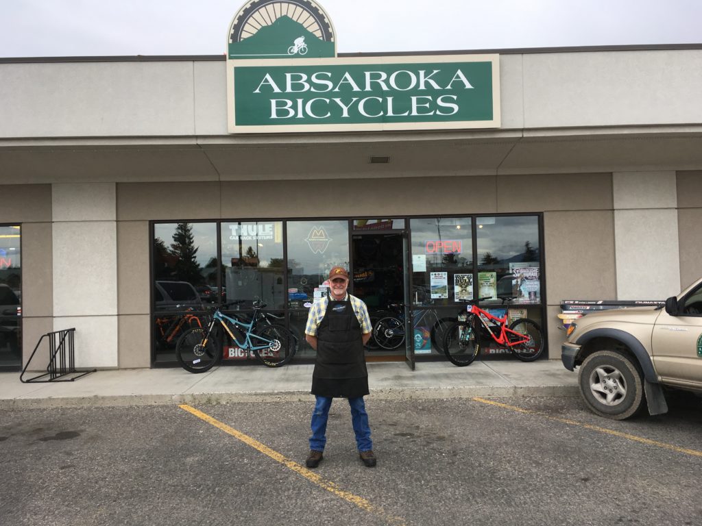
Rick Roach of Absaroka Bicycles in Cody Wyoming is retiring and selling the shop. Photo courtesy Rick Roach
Letter to the Editor:
Fifteen years ago I opened Absaroka Bicycle in Cody, Wyoming. There was not a bike shop in Cody at the time. I was riding and racing bikes back in the late 90s and early 2000’s and struggling to get work done on my bike. I thought to myself, I can’t be the only one in Cody who had to travel to get good bike service. Having formal training in mechanics in both auto and aviation I figured bicycles couldn’t be that hard! So I rolled the dice, quit my job as a project manager for a construction company, and enrolled at the United Bicycle Institute for their Certified Bicycle Mechanic program. We opened April 7, 2003. The rest is history. Originally my idea was to start a Back Country Mountain Bike Guide Service. What I didn’t know was how hard it was to get a permit to operate on the US Forest. We submitted our first letter of application in April 2002. After eleven years of persistent letter writing, phone calls, meetings, and even the creation of a local task force we where finally issued a temporary special use permit in 2013 which was renewed for the following two years. In the spring of 2016 we where finally awarded our preferred outfitting license. We are now the only fully licensedMountain Bike/Backpacking Outfitter on the Oldest National Forest in the country: The Shoshone National Forest (established in 1891), where we operate as Absaroka Bikefitters and Back Country Guides.
So much has gone into the business. And the business just keeps growing. Recently our local bike club built a state of the art mountain bike park just behind the bike shop.
The shop needs some new energy. Someone with a passion for adventure, bikes and business. So I have decided to sell my business. But not to just anyone. I am looking for someone that is at home in the hills, rain or shine and can still operate a family owned, family orientedand family run Bike Shop. I hope to find them soon, as I have so many places still to explore. But until then we will be in the shop and in the hills just taking care of customers like we have for all these years.
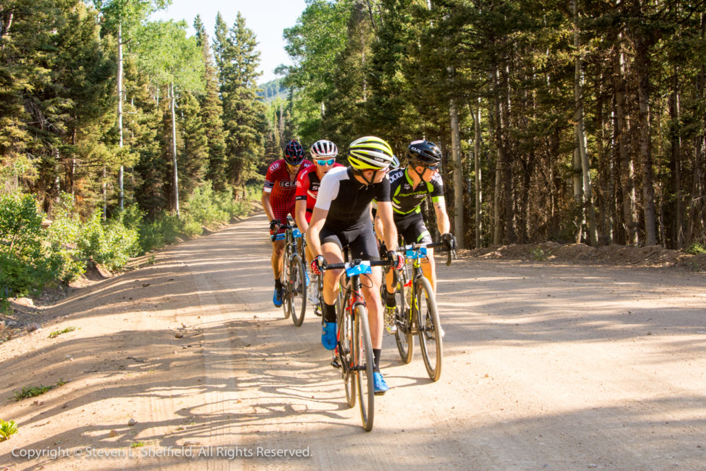
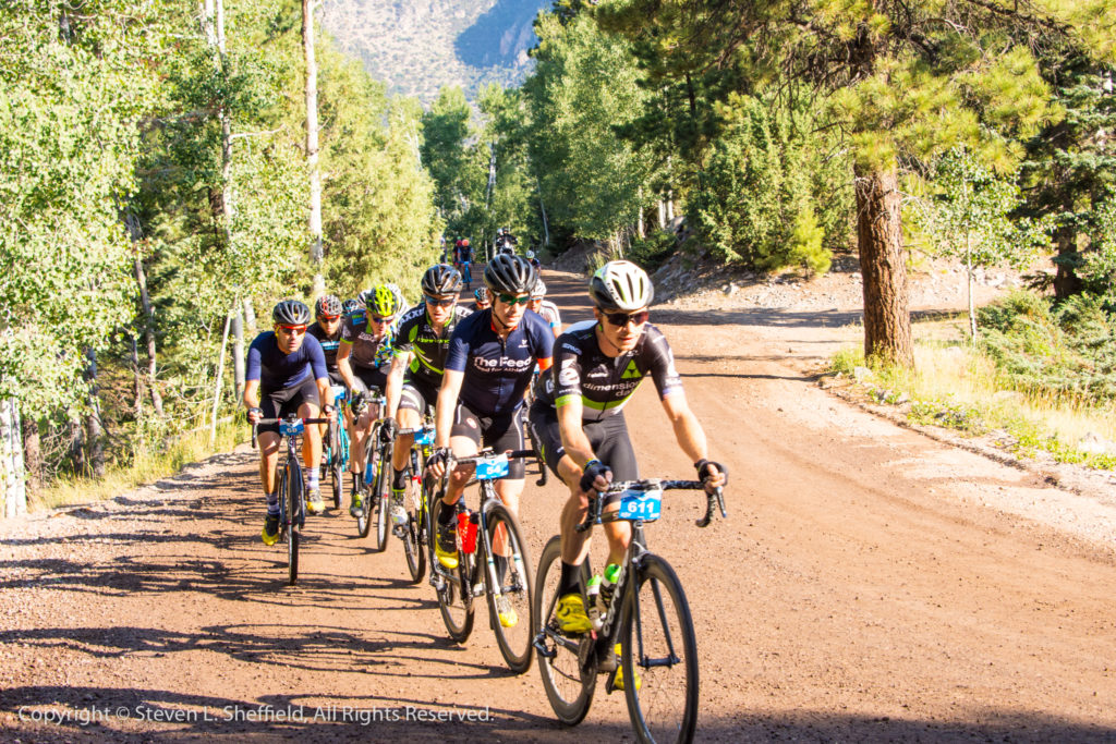
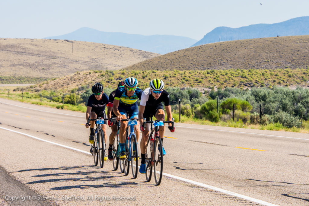
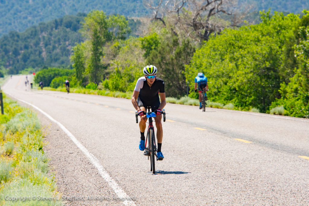
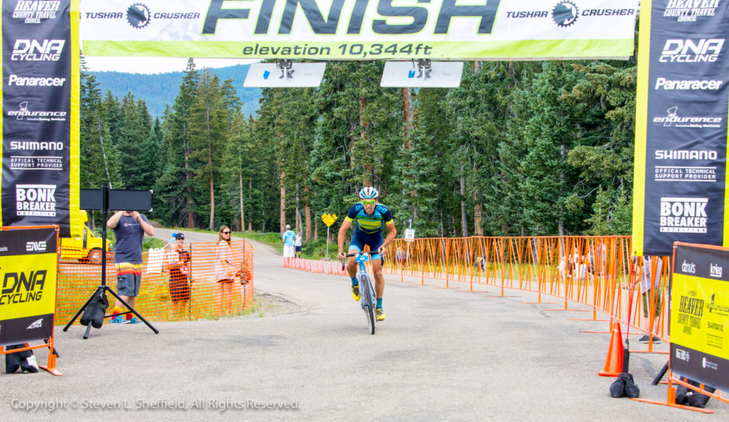
By Jackie Tyson — The 2017 Larry H. Miller Tour of Utah men’s professional cycling stage race returns for a 13th year, July 31-Aug. 6. The 605-mile course will include 36,525 vertical feet of climbing for 16 of the most prominent men’s pro cycling teams in the world. These teams will bring more than 120 athletes representing 20 or more countries.
True to the name “America’s Toughest Stage Race”, the event will feature three mountaintop finishes, one being an uphill individual time trial. It will feature all the twists and turns, climbing and descending, deserts and forests that make this race great to watch and a challenge to race. The race will again be broadcast start to finish each day on Tour Tracker, and the final two hours each day on FOX Sports Networks across the U.S. The Tour of Utah is the only pro stage race in North America that has comprehensive Tour Tracker coverage for every mile. Once you download the app for your iPad, iPhone or Android device, take it with you to a start line, a finish line, or in between, and never miss any of the action.
But the best way to enjoy the Tour of Utah is in person. “I have been in the professional cycling world for years and know the ins and outs to the point that pro cycling is routine to me. It is special to take something that I have done around the world and bring it home to where I grew up and fell in love with cycling,” said pro cyclists and Utah native Rob Squire, who will return to the Tour of Utah this year with the Canyon Bicycles-Scott team. Squire has finished in the Top 10 of the General Classification the past two years.
“My favorite part of the Tour of Utah is getting to race in front of my friends and family. Watching on TV is one thing, which is cool in its own right, but witnessing the race in person is totally different. Mountains look big on TV, but when my friends drive up Little Cottonwood (to Snowbird Resort), they can really appreciate the feat of racing up it. In addition to the physical accomplishment, no one is quite ready to see how fast we go on our bikes. The last few years I have hit speeds of 60-plus mph, that’s no joke in spandex and on skinny tires, and always impresses.”
Here’s how to watch Rob, his teammates and all the pros up close at the Tour this year.
PRE-RACE FESTIVITIES
Team Presentation
Saturday, July 29 from 6 to 7:30 p.m.
Logan Golf and Country Club
710 North 1500 East, Logan, Utah
Race week begins with the Tour of Utah Team Presentation, a free event for spectators in a relaxed environment on Saturday, July 29 in Logan. Cycling fans are invited to meet and greet all the cyclists who will be competing in this year’s Tour of Utah. Each team will be introduced on an event stage and top riders interviewed by one of the race announcers. Spectators are encouraged to bring a camera to capture photos of favorite athletes. The Logan Golf and Country Club will host the event for a second time. Reserved seating with complimentary beverages and food are part of the Team Presentation Experience Package, so check for details at TourofUtah.com.
EVERY DAY DURING RACE WEEK
Papa John’s Rider Sign-In and Autograph Alley
One hour before each stage begins, fans are given access to all the riders for autographs and photographs. It is free for all spectators, and takes place adjacent to the announcer’s stage at the start line. Thanks to Papa John’s, the entire family can get close enough to see and hear the top stars of the peloton.
Kids Sprint to the Finish presented by University of Utah Health
Children ages five to12 have the opportunity to race their bicycles on part of the course used by the pros. Two great reasons to participate – it’s free and it’s fun! To participate, parents or guard-ians must register their children at the University of Utah Health exhibit in the Harmons Healthy Living Expo (see addresses for Expo below). Make sure each child has a helmet and closed-toe shoes for a safe experience on his/her bicycle! Registration ends 15 minutes prior to each race (times listed are start times):
Monday, July 31 – Logan – Noon
Tuesday, Aug. 1 – Snowbasin – Noon
Wednesday, Aug. 2 – Big Cottonwood Canyon – 11 a.m.
Thursday, Aug. 3 – South Jordan City – Noon
Friday, Aug. 4 – Bountiful – Noon
Saturday, Aug. 5 – no races
Sunday, Aug. 6 – Salt Lake City – 1:30 p.m.
Harmons Healthy Living Expo
Plan to arrive early to any of the seven finish line host venues and spend some time at the Har-mons Healthy Living Expo. This free, interactive festival area and sponsor showcase serves as a gateway to the finish line every day. It provides an array of interactive exhibits, official Tour merchandise and live entertainment, including jumbo television screens to watch the race unfold as it heads to the finish. Listed below are the street addresses for each day’s finish line of the race, and the hours for the Harmons Healthy Living Expo:
Monday, July 31 Logan, 138 N. 100 East, 8 a.m. to 2:30 p.m.
Tuesday, Aug. 1 Snowbasin, 3925 Snow Basin Road (Huntsville), 11 a.m. to 2:30 p.m.
Wednesday, Aug. 2 Big Cottonwood Canyon, 8183 S Brighton Loop Rd. (Brighton), 9 a.m. to 2:30 p.m.
Thursday, Aug. 3 South Jordan City, 10996 S. Redwood Rd., 9 a.m. to 2:30 p.m.
Friday, Aug. 4 Bountiful, 20 S. Main St., 11 a.m. to 2:30 p.m.
Saturday, Aug. 5 Snowbird Resort, 100 Little Cottonwood Canyon (Snowbird), Noon to 4:30 p.m.
Sunday, Aug. 6 Salt Lake City, 315 E. Capitol St., Noon to 4:30 p.m.
RACE WEEK
Monday, July 31, Stage 1 presented by America First Credit Union, Logan to Logan
132 miles – 6,550 feet of climbing
Start Time 8:35 a.m.
Finish Time 1:45 p.m.
Start/Finish Location – 138 N. 100 East, Logan, UT 84321
The Tour of Utah will start in northern Utah with a return visit to Logan and Cache County. Stage 1 presented by America First Credit Union is the longest day of the Tour of Utah at 132 miles. Home to Utah State University, Logan previously served as the overall start community for the 2015 Tour of Utah. This is the same route used two years ago, rolling across scenic roads in two states and testing the legs with 6,550 feet of elevation gain. The race will begin with one lap of a downtown circuit, proceeding northbound (clockwise) on 100 East and proceeding in a clockwise direction along 300 North, 200 East, Center Street and back to 100 East. Then the peloton of 120-plus riders will head north through Logan Canyon, a rugged area that offers a Utah Office of Tourism King of the Mountain climb (in both directions). From Garden City, the first Utah Sports Commission Sprint line will await on the Idaho state border.
The route will navigate clockwise for 48 miles around Bear Lake, known as the “Caribbean of the Rockies” for its turquoise-colored water. Riders hope to leave strong crosswinds behind as they return through Garden City for the short, but difficult, climb back up Logan Canyon. After a long descent on Highway 89 that passes Utah State University, riders will complete two downtown laps in Logan for an exciting finish on 100 East. The finishing circuits will favor a rider with strong technical skills and spectators will most likely enjoy a large field sprint.
Tour Tips Stage 1:
The Tour will use sections of U.S. 89 in Utah and Idaho, State Road 30 in Utah and East Shore Drive in Idaho during Stage 1. Expect traffic delays and temporary road closures at:
Utah State University on Hwy 89 between 8:30 to 8:45 a.m. for the start, and again between 1 to 2 p.m. for the finish. Once the race passes, intersections will reopen.
Beaver Mountain Access Road (State Road 243) in northbound direction for the Utah Office of Tourism King of the Mountain climb between 9:45 to 10:10 a.m. and in the southbound direction between Noon and 1 p.m.
Garden City along Hwy 89 in a northbound direction for a Utah Sports Commission Sprint line between 11:50 a.m. to 12:40 p.m., and along State Route 30 in a northbound direction from 11:50 a.m. to 12:35 p.m.
Fish Haven, Idaho between 10:15 a.m. to 10:50 a.m. and St. Charles, Idaho between 10:25 a.m. to 11:15 a.m.
Bear Lake State Park Beach on North Beach Road between 10:35 a.m. to 11:30 a.m.
For 20 miles along Eastshore Road in southbound direction between 10:45 a.m. to 12:30 p.m.
The race will feature two circuits in downtown Logan for the finish. Streets closed for these loops include sections of 100 East, Center Street, 200 East, Boulevard Drive, 500 East, 400 North, and back to 100 East. Roads will be closed along this route between 1:10 to 2:10 p.m.
Tuesday, Aug. 1, Stage 2, Brigham City to Snowbasin Resort
94 miles – 6,900 feet of climbing
Start Time 9:45 a.m.
Finish Time 1:45 p.m.
Start Location – 1 S Main St, Brigham City, UT 84302
Finish Location – 3925 Snow Basin Rd, Huntsville, UT 84317
The town of Brigham City has seen the Tour of Utah pass through its pristine community in prior years, but this “Gateway to the World’s Greatest Bird Refuge” will host a stage start for the first time. The 94-mile climbing affair on Tuesday begins with two neutral laps in downtown Brigham City, starting on Main Street near 100 South. It only takes 11 miles into the stage before the racers encounter the first of three Utah Office of Tourism KOMs at Sardine Canyon. This is a narrow road that hugs the side of Mt. Sterling. The route will circumnavigate the Wellsville Mountains.
The route will take State Highways 30 and 38 to circle the Wellsville Mountains in a counter-clockwise direction for 51 miles. Riders should be glad to go around these peaks, a part of the Wasatch Mountains that is said to be the “steepest” mountain range in North America. Specta-tors will see the race return through Brigham City for a second Sprint line on Historic Main Street. Then the route will turn south and follow State Highway 89, also known as the Fruit Highway, to reach the often-used North Ogden Divide, a five-kilometer climb averaging a 10-percent gradient.
The racers can catch their breath as the road flattens out around Pineview Reservoir. But they won’t have much time to relax before the first mountaintop finish of this year’s Tour at Snow-basin Resort. Host of the men’s and women’s downhill, super-G and combined competitions at the 2002 Olympic Winter Games, Snowbasin is perched on top of Old Snowbasin Road. Snow-basin Resort is one of the oldest continuously-operating ski areas in the nation, having opened in 1940. The final climb has never been used as a finish of the Tour of Utah, and was last used in 2010 as a stage start. The double-pitched incline to the resort, covering six miles with an av-erage gradient of six percent, should make the first selection for the overall race General Classi-fication.
Tour Tips Stage 2:
The race will pass through Brigham City a second time on Main Street (Highway 13) for a Utah Sports Commission Sprint line between 11:35 a.m. to 12:15 p.m.
The race will use 600 West and Weber High Drive to cross the North Ogden Divide for the second Utah Office of Tourism KOM climb. Expect delays along N. Ogden Canyon Road between Noon to 1 p.m.
The race will use N. 5500 East and E 1900 North to pass through Eden between 12:30 to 1:15 p.m.
The race will use 7800 East to pass on the east side of Pineview Reservoir and Huntsville between 12:45 to 1:30 p.m.
The finish line is located at 3925 Snow Basin Road. Spectator traffic should use State Route 167 to access Harmons Healthy Living Expo, VIP Hospitality and other finish line activities at Snowbasin Resort.
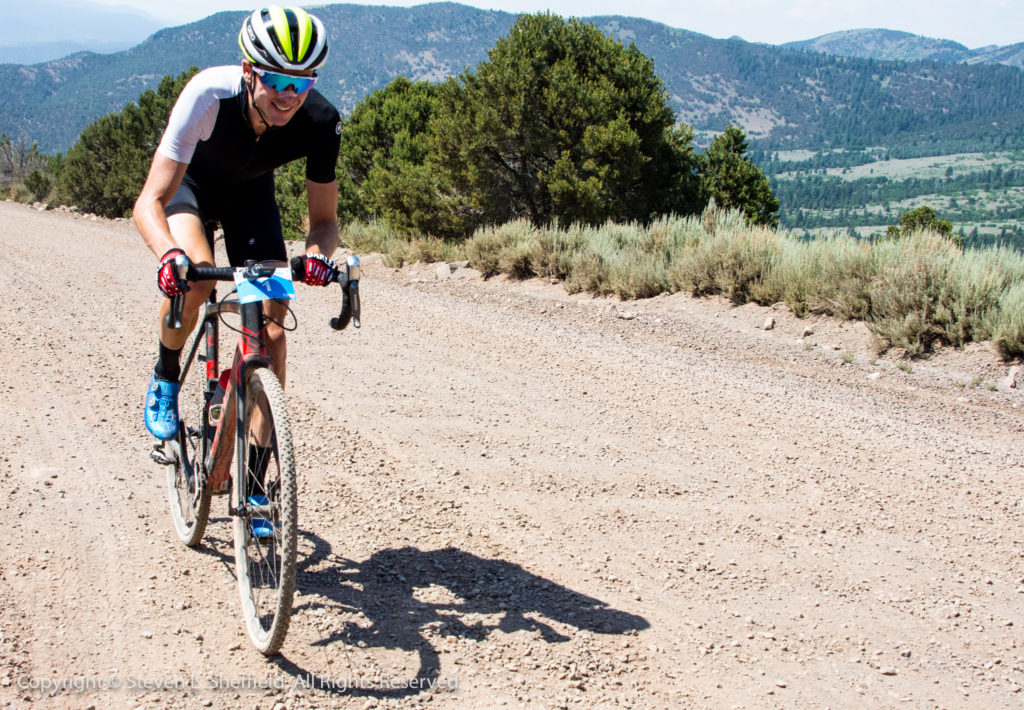
Wednesday, Aug. 2, Stage 3, Big Cottonwood Canyon
5.6 miles – 1,725 feet of climbing
Start Time 11 a.m.
Finish Time 1:45 p.m.
Start Location – Donut Falls Trailhead on Big Cottonwood Canyon Rd
Finish Location – 8183 S. Brighton Loop Rd, Brighton, UT 84121
Making a return to the Tour of Utah from a six-year absence is the popular individual time trial, known as the race against the clock. In 2011, American Tejay Van Garderen (riding for HTC-Highroad) won the Stage 3 ITT on his 23rd birthday at Miller Motorsports Park. The 2017 ITT will look nothing like the flat parcours of the race track. Starting at an elevation of 7,300 feet, the course climbs 1,725 vertical feet and provides a tough 5.6-mile ascent of Big Cottonwood Can-yon Road, from the Donut Falls Trailhead parking at Reynolds Gulch to the front door of Bright-on Ski Resort. The route passes Solitude Ski Resort and the turnoff to Guardsman Pass, flanked along the road by towering spruce trees and rock vistas that are part of the Uinta-Wasatch-Cache National Forest. With an average gradient of 5.5%, the course should favor a strong rider who excels at high altitude.
“ITT’s are unique races, but they are fun to watch and you really get to see every rider,” said the former collegiate road champion and Utah native Cortlan Brown, a teammate with Squire on Canyon Bicycles-Scott. “It’s a beautiful canyon, it’s a great place to come spend the day and watch a bike race. Watch some of the best cyclists going full gas up some of the steepest parts of the canyon.”
Tour Tips Stage 3:
The six-mile section of Big Cottonwood Canyon Road used for the ITT will CLOSE TO ALL VEHICULAR TRAFFIC beginning at 9 a.m.
There is no public parking at Brighton Resort, or along S. Guardsman Pass Road.
There will be limited parking at Solitude Mountain Resort, which will be available until 9 a.m.
Utah Transit Authority will operate its ski bus service route along Big Cottonwood Canyon on the day of the ITT. Buses will operate beginning at 7 a.m. from the Big Cottonwood Canyon Park & Ride lot only.
Limited shuttle service will circulate between the ITT start and finish lines before the race begins.
Thursday, Aug. 3, Stage 4 presented by Workfront, South Jordan to South Jordan
125 miles – 4,000 feet of climbing
Start Time 8:55 a.m.
Finish Time 1:45 p.m.
Start/Finish Location – 10996 S. Redwood Rd, South Jordan, UT 84095
This wild west stage covers 129 miles with a new start/finish in South Jordan, and could be the sleeping monster of the 2017 Tour of Utah. The inaugural start/finish in South Jordan, located on Redwood Road next to South Jordan City Park. The race will use 14000 South to reach the Mountain View Corridor and head to the west desert and Rush Valley on State Roads 73 and 36. The out-and-back section of SR 73 will offer a Utah Sports Commission Sprint line in Cedar Fort in both directions. The race uses a 36-mile section of SR 73, and a 15-mile section of SR 36.
The peloton will connect to the old Pony Express Trail in Tooele County and cross Five Mile Pass. This is not significant for the elevation gain, but rather for its history as a main thorough-fare in the 1800s for the stagecoach and pioneer families heading west. Here in the shadows of the Oquirrh Mountains, riders will find little protection from the elements, especially the wind. Another surprise for the riders will be Faust Road, a previously paved surface that is now 10 miles of maintained dirt and gravel. There will be two finishing circuits of three miles each around South Jordan City Park.
Tour Tips:
The first pass through Cedar Fort for a Utah Sports Commission Sprint line is between 9:55 to 10:20 a.m.
The second pass through Cedar Fort for the second Utah Sports Commission Sprint line will be contested in Cedar Fort between 12:15 to 1 p.m.
After passing Saratoga Springs and Bluffdale along Redwood Road on the return back to South Jordan, the race will move northbound on Mountain View Corridor, then using W. 11400 South and 4000 West to turn east on South Jordan Parkway. Expect the race to pass in these areas between 12:50 to 1:30 p.m.
The race will turn south on Redwood Road for two finish circuits around South Jordan City Park – South on Redwood Road, right on W. 11400 South, right on 2200 West, right on South Jordan Parkway, and right on Redwood Road.
Friday, Aug. 4, Stage 5 presented by Zions Bankd, Layton to Bountiful
115 miles – 4,200 feet of climbing
Start Time 9:10 a.m.
Finish Time 1:45 p.m.
Start Location – 465 N. Wasatch Dr, Layton, UT 84041
Finish Location – 20 S. Main St., Bountiful, UT 84010
The Tour is back in Davis County for a third consecutive year, which is quickly becoming a fan favorite for the Tour of Utah with big crowds and dynamic racing. New for 2017 will be an inaugural stage start in Layton, which will provide spectators with two opportunities to view the race. The 115-mile course rolls toward Hooper and the Great Salt Lake for 53 miles of rural roads in Davis and Weber counties. Passing through downtown Layton for a second time, the Utah Sports Commission Sprint line will be staged at Wasatch Drive.
A new section of the course will take State Road 93 to access Hill Air Force Base for the first time, using the South Gate Entrance. The military base is the home of the F-16 and F-35 fighter jets, and provides worldwide engineering and logistics management for the F-16 Fighting Fal-con, A-10 Thunderbolt II, and Minuteman III intercontinental ballistic missile. The route will fol-low Foulois Road to Wardleigh Road, exiting near the Hill Aerospace Museum, the largest mu-seum west of the Mississippi River.
The route will follow sections of U.S. Highway 89 and Mountain Road to reach the nine-mile circuits in Bountiful, with the crushing climbs up the Bountiful Bench used each of the past two years. Each pass over the Bountiful Bench is designated as a Utah Office of Tourism KOM climb. There is always a close finish on Main Street at Center Street, with the peloton racing in the northbound direction. The winner is going to be a strong rouleur who can get over the climbs and outkick those few remaining in the peloton.
“400 North is a classic Bountiful climb to test out your legs,” said Brown, who is from Bountiful and still trains in the area. “I think that there are some great places along 400 North to watch the race, right above Davis Blvd. will show you the steepest part of the climb, or a little higher the views are great and the climb doesn’t let up. The great thing is if you hurry, you can make it downtown to the finish before the race to watch the final.”
Tour Tips:
In Layton, the race will roll from N. Wasatch Drive at Constitution Circle, and turn right on Layton Parkway. The race will use 2200 West to turn left on Gentile Street and continue in westbound direc-tion for 7.5 miles.
The race will return to Main Street and Wasatch Drive a second time for a Utah Sports Commission Sprint line between 11:15 to 11:35 a.m.
Using Antelope Drive, the race will travel northbound on Hobs Creek Drive for one mile, and turn west on State Route 93 to access the South Gate of Hill Air Force Base. Only authorized vehicles in the race caravan will be permitted on HAFB.
The race will follow Balmer Avenue, Foulois Road and Wardley roads on the property of HAFB. The race will exit via the Roy Gate, near the Hill Aerospace Museum, between 11:50 a. m. to 12:30 p.m.
The race is expected to reach Bountiful, using Pages Lane and 400 East to then turn left on 400 North for the first to two laps on the Bountiful Bench climb. The race should make the turn on 400 North between 12:50 to 1:30 p.m.
After turning left on 400 North, the race will make two complete laps on a circuit that includes Bountiful Boulevard, Indian Springs Rd., 400 East, Davis Boulevard, 400 East, 1800 South, Orchard Dr., 500 South, and on to Main Street. The race will then turn right onto 200 North to 400 East, turn left at 400 East and return to 400 North.
Saturday, Aug. 5, Stage 6 presented by University of Utah Health, Heber Valley to Snowbird Resort
61 miles – 7,700 feet of climbing
Start Time 1:10 p.m.
Finish Time 3:45 p.m.
Start Location – 2002 Soldier Hollow Dr., Midway, UT 84049
Finish Location – 100 Little Cottonwood Canyon, Snowbird, UT 84092
The Queen Stage with the epic finish at Snowbird Resort has traditionally had a big impact on who wins the G.C. of the Tour of Utah. Don’t let the mileage fool you. At 62 miles, the course is much shorter than previous editions, but that just means the race will be that much harder and more dynamic. This year’s course harkens back to the original route over Alpine Loop that was introduced in 2006. It is the second time a stage has started in the southeast corner of the Heber Valley in the shadow of Mount Timpanogos at Soldier Hollow, where nordic competitions were held for the 2002 Olympic Winter Games. The entire area sits in Wasatch Mountain State Park. After rolling out from the stadium at Soldier Hollow, the racers will only have a few miles around Deer Creek Reservoir before tackling the Alpine Loop, a Category 1 climb that runs be-side Sundance Resort. Passing through American Fork Canyon and Timpanogos Cave National Monument, this route was first used on the Queen Stage in 2008. The route travels through the cities of Draper and Sandy before passing throngs of fans at Tanners Flat for the final fireworks on the Hors Category climb to Snowbird Resort. This is the 10th consecutive year that Snowbird Resort has hosted a stage finish, with the signature climb featuring 8-12 percent gradients on the final six miles through Little Cottonwood Canyon.
“Snowbird is a legendary stage and as long as the climb up to there is included it will be deci-sive. I marked it on the calendar last year the day after I was 6th on that stage,” said Squire.
And pro cyclists are not the only ones on the route Saturday. Amateur riders in The Ultimate Challenge presented by University of Utah Health will ride the same roads on Saturday between 9:30 a.m. to 2 p.m. If you are traveling on the roads, use caution and watch for cyclists! This marks the eighth year for this non-competitive, gran fondo-style bicycle ride. Registration for The Ultimate Challenge is available online for $140, with a team discount offered for groups of eight or more.
Tour Tips:
The race will turn west on Highway 92/Alpine Scenic Loop and is expected to pass Sundance Resort between 1:40 to 1:50 p.m.
The race will continue westbound on Hwy 92 for 27 miles. A Utah Office of Tourism King of the Mountain is located at the summit of American Fork Canyon, with racers expected to crest this area between 2 to 2:15 p.m.
Along Hwy 92 the race will pass Timpanogos Cave National Monument, expected between 2:15 to 2:25 p.m.
The race will pass north through Draper on 1300 East for a Utah Sports Commission Sprint line between 2:50 to 3:25 p.m.
Little Cottonwood Canyon Road will be closed to all vehicular and bicycle traffic between 1 to 5 p.m. Plan your arrival to the finish line accordingly. Follow signs at Snowbird to free spectator parking.
Sunday, Aug. 6, Stage 7 presented by Utah Sports Commission, Salt Lake City to Salt Lake City
73 miles – 5,450 feet of climbing
Start Time 1:10 p.m.
Finish Time 3:45 p.m.
Start/Finish Location – 315 E. Capitol St., Salt Lake City, UT 84103
The original Salt Lake City circuit is back. With the start/finish line on the east side of the Utah State Capital, this circuit is the one used in 2013 and is a favorite of the racers and spectators alike. There will be 11 laps of the 6.8-mile circuit, including two intermediate sprints and a time bonus at the finish for the top three. The overall race champion may not be decided until the very end. The major climb of the circuit is along State Street, and provides a great opportunity to see the racers up close as they suffer on this steep section. Other viewing areas include Bonneville Blvd. around City Creek Canyon, a fast turn from 11th Ave. to N. Virginia St. at Pop-perton Park, and the serpentine turns around Reservoir Park.
“As a fan, this has been one of my favorite stages to watch,” added Brown. “Camping out on State Street is a great idea, or around the Capitol. But if you want to see the real speed that the racers will reach, N. Virginia St. would be another awesome place to view the race.”
Squire added, “State Street is an excellent viewing spot, because it is right next to the finish and is likely where most of the racing action will be. That being said, the speeds at which we will come out of The Avenues and approach the finish is always impressive and worth checking out.”
Tour Tips:
Police will begin closing the roads to traffic on the circuit at approximately 12:45 p.m.
Each lap is expected to take approximately 20 minutes to complete.
The race will pass Reservoir Park three times on each circuit, allowing for multiple opportuni-ties to see professional cyclists up close and at high speed.
The State Street climb, between North Temple and the Capitol, is a great place to see the best pro cyclists tackle the steepest section of the course.
Pedestrians are welcome to walk the course. However, we request that you stay on the side-walks, and do not impede the movement of local residents, police and course marshals who will be using the respites between circuits to move people in and out of the neighborhoods.
Use Utah Transit Authority’s TRAX Blue Line or Green Line for easy access to course from the City Center stop (100 S. Main Street). One-way ticket is $2.50; Day Pass is $6.25.
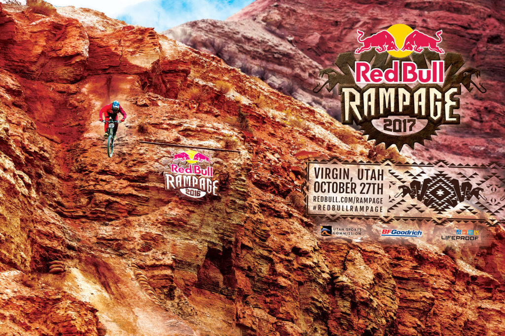
The Red Bull Rampage will return to Virgin, Utah on October 27, 2017. Graphic courtesy Red Bull.
Semenuk, Sorge and Strait Positioned for Hat Trick; Pre-Qualified Athletes Announced
Press Release – Virgin, Utah (July 26, 2017) – The date is set for one of the biggest tests of skill and toughness in mountain biking. On October 27, Red Bull Rampage returns marking the 12th edition of the storied event. Set in one of the most demanding locations on the planet, the event has become the most coveted title in Freeride Mountain Biking. This fall, 21 of the world’s greatest riders will once again descend upon Virgin, Utah’s distinctive landscape as they fight to claim their place atop the Rampage podium. More information about exclusive spectator tickets and event experiences will be announced in the coming weeks.
This year’s event features familiar faces along with some new terrain. Brandon Semenuk, Kurt Sorge and Kyle Strait have been invited back as part of the Pre-Qualified roster, having all taken home the gold twice in years past, setting them up for the potential hat trick this year. To make things even more interesting, a new additional ridge will be opened up at the venue, which should allow the possibility for new lines.
Building upon the success of last year’s format changes, the elite group of 21 riders will create their own manmade lines down the mountain without the use of power tools. As a result, no two rider’s path down the near-vertical sandstone ridges will be the same. In advance of the competition, the riders, along with their two-person build crews, are welcomed to the event site for four days of building and then four additional days to practice with their bikes in order to build their line in what is touted as one of the most intense contests in the world.
PRE-QUALIFIED ATHLETES FOR RED BULL RAMPAGE 2017
1. Brandon Semenuk (CAN)
2. Antoine Bizet (FRA)
3. Carson Storch (USA)
4. Kurt Sorge (CAN)
5. Kyle Strait (USA)
6. Thomas Genon (BEL)
7. Tyler McCaul (USA)
8. Andreu Lacondeguy (SPA)
9. Pierre Edouard Ferry (FRA)
10. Tom Van Steenbergen (CAN)
Invited Wild Card and Alternate athletes to be announced.
Rampage airs as part of the Red Bull Signature Series, a collection of the most progressive and innovative events in action sports. Fans can watch the event live on Red Bull TV or as a highlight program on NBC Sunday, December 24. The event is supported by BFGoodrich Tires, Utah Sports Commission and Lifeproof.
Cycling West and Cycling Utah Magazine’s July 2017 Issue is now available as a free download (10 mb download), Pick up a copy at your favorite Utah, Idaho, Wyoming, Nevada, Montana, W. Colorado, N. Arizona bike shop or other location!
Cycling West July 2017 Cover Photo: Fears, Tears & Beers enduro race organizer Kelly Ernest, enjoys a post-race ride at Cave Lake State Park, a few miles east of Ely, Nevada. Photo by John Shafer
Contents
2017 Larry H. Miller Tour of Utah Where to Watch Guide – page – 3
Perseverance Pays off for Commuter and Mechanic Mollie Bourdos – page – 4
Michael Ray Wants to Inspire Others – page – 6
Balancing the Insanity: Finding Time for Training – page – 7
Summit Challenge Set for August 26, 2017 – page – 8
Tour Time! – page – 9
What Should I Do If I’ve Been Involved in a Hit-and-Run Crash? – page – 10
Salt Lake County Bicycle Advisory Committee News for July 2017: New Bike Map, Kids Safety, Participate – page – 10
Do I need a Special Bike for a Triathlon? – page – 11
Long Time Adventurer and Bike Shop Owner in Cody Wyoming Retiring – page – 14
Utah Riders and Teams to Watch page – 21
Holley and Stuart Win Intermountain Cup’s Wasatch 50 – page – 21
Greater Yellowstone Trail Wins Grant to Further Completion – page – 27
Bike Lanes Coming to Skyline Drive in Pleasant View, Utah page – 27
Bike Utah to Start Bicycle Friendly Driver Program – page – 27
Down and Out (Literally) or “My Latest Bike Wreck” – page – 28
Boise’s Police Department is New Bike Friendly Business; Guru’s Donut Shop Isn’t Far Behind – page – 29
Why? – page – 30
The Cedar City Fire Road 2017 Preview – page – 31
Lightning In A Saddle: The Evelyn Hamilton Story – page – 32
Fast After Fifty is An Informative Read for the Older Athlete – page – 33
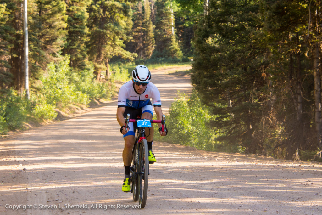
By Dave Iltis — This year’s Tour of Utah will feature a number of Utah riders and a locally based team.Hangar 15 Bicycles Pro Racing (was Canyon Bicycles Pro Racing) is Utah’s pro team. They received their first invite to the Tour of Utah in six years. Look for Paco Mancebo, Rob Squire, Cortlan Brown, Erik Slack, Kaler Marshall, Steve Fisher, Chris Winn, and Chad Beyer and others out on course. The new Hangar 15 jerseys will be similar to the iconic Canyon jerseys that have been part of Utah’s race scene for the last 10 plus years.
Another Utah rider to watch will be fan favorite TJ Eisenhart of the Holowesko Citadel squad. TJ finished 7th last year overall and will be in the mix as a favorite for the overall in 2017.
Park City’s Tanner Putt will likely return this year for UnitedHealthCare Pro Cycling. He’s a rouleur with a great sprint, and likely leadout man for teammate Travis McCabe. Putt has potential to win a stage in the right conditions.
[Note that team rosters won’t be final until just before the race.]
A trail network that traverses three states has received a 2017 grant from the Rails-to-Trails Conservancy (RTC). Wyoming Pathways (WP) will use the money to leverage other resources to fill gaps in and make connections to the 180-mile Greater Yellowstone Trail, which will run between Jackson Hole, WY through eastern Idaho to West Yellowstone, MT.
WP won the grant competitively from RTC’s Doppelt Family Trail Development Fund, which, RTC explains, funds “small, regional projects that are vital to trail systems but often fall through the cracks of traditional funding streams.” (Disclosure: I am an RTC member.)
The goal is to close gaps in the trail (such as between Jackson Hole in Wyoming and Idaho) and link with other trails and communities so as to create a 260-mile bike loop, as well as make improvements to existing facilities and build bridges.
“At the most base level of practicality, we knew WP and we knew the great work they have done and we wanted to continue their efforts,” explains Eli Griffen, RTC’s manager of trail development resources and manager of the Doppelt Fund grant program. Griffen ackowledges that RTC hasn’t funded many projects in the area recently. Keep your eyes open, though. “We would like to be more active in that part of the country,” Griffen says.
WP will use the grant to continue planning and network with partners along the corridor, including local municipalities, public land agencies and county governments. “We’ll follow up with them and gather information on how individual projects are going,” explains WP Executive Director Tim Young. He also hopes to use the grant to leverage other funding, such as federal grants to construct the trail.
WP is charged with using the Doppelt money to hire the Bozeman, MT office of Alta Planning + Design this summer to help “branding,” or developing a “unique identity” for the trail and sort out priority sections to seek further funding for, Young says. Alta has done previous work on the project, such a making a map for the Missoula MT section.
While most of the trail is bikeable and hikable now (you’d probably want a mountain bike on some of it), “it will be some time before every section is finished and every sign is up but it’s a big project and that’s understandable,” Young explains. A current $2.2 million grant is financing finishing the trail between Victor, ID and the Wyoming border. The two-mile segment should be open in the next year or two, Young says.
“We knew that $20,000 is a drop in the bucket for this,” Griffen says, “but we hope it will spur other donors to give.”
“We love the possibility of integrating several trails into a larger network. This project will connect at least three rail-trails and provide another amenity for tourists in the area who are already coming to see Grand Teton and Yellowstone national parks, but also for the residents in the area,” Griffen says.
Under the terms of the grant, WP must spend the money this year.
In May, the Greater Yellowstone Trail Concept Plan won the Trail Planning & Design award in the greater than $500,000 category at the American Trails International Trails Symposium.
By Charles Pekow — Cities that have pushed the Bicycle Friendly Business (BFB) program by now have probably picked all the low hanging fruit. Bicycle and other athletic companies, health outfits, breweries and landscape/architecture firms have been climbing on board all along. Yet the two cities with the most BFBs are continuing to push the program in new ways. Fort Collins, CO now leads the nation with 60, including five picked up so far this year in the winter and spring announcements.
Second place belongs to Boise, ID at 46, as the Boise Bicycle Project (BBP) keeps coming up with imaginative ways to expand, including four new ones and one honorable mention this year.
But in addition to picking up a brewery and bike shop, Boise added its police department. And the honorable mention went to a doughnut shop.
“We are starting to see a wide variety of businesses coming from these places,” notes Amelia Neptune, Bicycle Friendly America Director for the League of American Bicyclists (LAB).
A Boise Police Department (BPD) substation won silver, a step above bronze but below gold. “Before we got their application, we were aware of BPD because they came up in other applications,” Neptune says. “Boise State University (BSU) mentioned partnering with them on education” and other aspects of its successful application.
The winning station employs 17 people but has indoor parking for 20 bicycles. Boise’s other police station lies in a remote location, not very accessible for bicycles or fit for a BFB award, explains officer Blake Slater.
The police impressed LAB with its efforts to work with the community. It takes an active role working with BBP, BSU and the Treasure Valley Cycling Alliance on projects and the mayor’s bicycle advisory committee, which gives city government a good ear when it comes to making infrastructure changes or adding stop signs.
The police work not only with BBP and BSU but with the Treasure Valley Cycling Alliance. The department helps with the local YMCA’s Safe Routes to School, teaching all third graders about riding safely. Two staffers have earned league cycling instructor status from LAB. BPD organizes “Bike with the Cops” and “Pedal with the Police” rides around the popular Greenbelt bikepath along the Boise River, including showing safety techniques. “We always finish with ice cream; the best thing on a hot day,” Slater says.
The police are working on a ticket diversion program where cyclists given traffic tickets can attend a safety class in lieu of paying a fine. Slater says, however, that unless cyclists cause an accident, they don’t get many tickets, as state law allows them to treat stop signs as yield signs and red lights as stop signs. A few get cited for riding the wrong way or failing to yield, though.
And if BPD wants to earn gold or higher status? It could get more cops to ride to work and gather more data on local ridership, LAB suggests. Slater says the department is hoping to open a new building next year that will allow people to cycle in and park, which the current structure doesn’t allow. He adds that the department is looking at better ways to extrapolate useful bike-related data from its files.
Guru Donuts
Meanwhile, Guru Donuts, a local business and new applicant on Main Street in Boise, applied for the first time and got Honorable Mention, not quite good enough for BFB.
“They impressed us because they have bike events,” such as participating in Bike to Work Day, Neptune says. The doughnut hole in the application? “The reason we didn’t feel they were (a BFB) yet is is they don’t have formal bike parking. Bikes are allowed inside but they don’t have secure bike parking. They also don’t have any incentives yet” for employees to ride to work.” LAB also suggested offering discounts to customers who come in on bike.
Even without employee incentives, “a lot of the staff members ride our bikes to work because it is easier to access downtown by bike rather than try to find parking,” explains Guru Retail Manager Robyn Lieggi. “We like trying to be healthy for a doughnut shop. We exercise.” The store lies fairly close to the Greenbelt.
It would be nice to offer discounts to cyclists, but “its kind of tricky to carry around a bunch of doughnuts (by bicycle without the right equipment) but if you’re on your bike on certain days, you get a free doughnut,” Lieggi says. Cyclists tend to like the cake doughnuts, she says.
But “they didn’t send any samples along with their application,” Neptune notes.
By Phil Sarnoff — Last month, Bike Utah announced the implementation of a Bicycle Friendly Driver Training that all new UTA bus operators will go through as part of their staff training. Over the course of the training, bus operators learn about: common crashes and how to avoid them; the principles behind sharing the road; different types of bicycle infrastructure; and the safety techniques taught to bicyclists, including taking the lane. The training also reviews numerous roadway scenarios.
“As a group, UTA bus operators spend more time on the roadways than probably any other group of drivers in Utah,” said Phil Sarnoff, executive director of Bike Utah. “They are also more likely to interact with people on bicycles given the location of bike lanes and bus stops. The UTA staff members in charge of bus operator training were very receptive to this idea and we are thrilled that this happened so quickly.”
“Safety always is the number-one priority at UTA,” said UTA Bus Operations Training Supervisor, Maria Stahl, “with the growing number of our riders who use their bicycles to connect with transit it increasingly becomes an area of attention. Cyclists are a growing segment on our streets, whether they are riding to board TRAX, FrontRunner or one of our buses or just pedaling from one part of town to another, we must be aware they are there to ensure their safety, as well as our own.”
The Bicycle Friendly Driver Training is modeled after a similar program in Fort Collins, Colorado. The Fort Collins program was started in December 2015. Since its inception the program has educated more than 2,000 drivers and worked with private citizens, businesses, schools, organizations, and municipalities to reach motorists. In addition, more than 110 people from communities across the nation (and even other parts of the world) have accessed their Bicycle Friendly Driver toolkit and many are starting their own programs in their communities.
Bike Utah is working to expand the training to existing UTA bus operators, state agencies, and businesses. They also plan to have an online training program available for the general public.
Organization, agencies, and businesses interested in setting up their own training program can contact Bike Utah’s Executive Director, Phil Sarnoff, at [email protected]
By Charles Pekow — Bike lanes will be included in an extension project for Skyline Drive Roadway in Pleasant View City, Utah. The Federal Highway Administration (FHWA) gave final approval to the project as it passed the environmental review and the next step is arranging financing.
“Now it’s in the city’s hands,” says Brandon Weston, director of environmental services, for the Utah Department of Transportation.
The plan calls for installing six-foot-wide bike lanes (one in each direction) right next to the auto lanes. The plan also calls for “tie-ins to trails near the Ogden-Brigham Canal, Pleasant View Drive and 1100 West,” according to the environmental assessment. The lanes would run from U.S. Rt. 89 on the west (with a connection to Pleasant View Drive) to 4300 North/1100 West on the East (what a directional amalgam!).
These facilities would allow bicycle access to the planned Skyline Trail (not to be confused with Skyline Drive), Pleasant View Drive and nearby connecting trails, as well as existing pathways and sidewalks on 4300 North. Plans also call for four trailheads in the area that the links would connect to, but trailhead development isn’t part of the Skyline Project.
Now, the age-old issue of finding money comes up. The city may seek federal funding, possibly seeking help from the Weber Area Council of Governments or the Wasatch Front Regional Council, Weston suggests. These organizations have been supportive of the project.
“This has been a long process. We know the communities are supporting active transportation and are doing the best they can with limited resources,’ says Mark Benigni of Weber Pathways.
Bill Cobabe, city administrator for Pleasant View City, who is overseeing the project, did not respond to telephone messages.
Anyone who disagrees with the environmental assessment can file suit until Nov. 6.
A father and child are forced to ride on the sidewalk on 2100 S since there are no bike lanes on 2100 S. Mayor Biskupski decided today to keep the status quo of a less safe 2100 S. Photo by Dave Iltis
July 13, 2017 – In an email to Councilpersons Luke and Adams, Salt Lake City Mayor Jackie Biskupski today decided that there will be no bike lanes on 2100 S from 1700 E to 2300 E.
The email states that despite the support for safety, reduced speed, and bike lanes , that the Mayor would keep the same configuration of 2 lanes in each direction with no center turn lane and no bike lanes. This configuration, according to Salt Lake City Transportation, is more dangerous for all road users – motorists, cyclists, and pedestrians. Yet, the Mayor seemed to give in to worries from local residents about potential congestion and held this as the deciding factor over safety and the Pedestrian and Bicycle Master Plan.
The Mayor did state that 2100 S should be looked at in its entirety, something that Cycling Utah included in our comments on the project.
The decision follows an extensive public outreach that gathered more than 1500 responses.
The responses of those who registered on the Open City Hall website (519 total) (http://www.slcgov.com/opencityhall) overwhelmingly favored making the route safer for bicycling and walking:
53.2% to 36%.
The ranked goals favored reducing congestion over improved conditions for bikes and pedestrians, but no totals were available.
53.7% favored a safer design of 2 lanes and a center turn lane, of which 46.2% favored bike lanes.
58.7% of respondents were willing to spend an extra minute or two during rush hour to have a safer 2100 S.
64.3% favored a reduction in speeding, which would have occurred with the Road Diet of 2 lanes, center turn lane, and bike lanes.
73.6% favored reducing congestion. Keeping the existing design will result in the same level of congestion, and is hence contrary to the desires of the survey respondents.
The email is below:
Dear Council Members Luke and Adams,
I wanted to let you know that after careful consideration and based on the community input we received over the last month, the Administration has decided not to pursue a change in lane configuration on 2100 South at this time.
The Transportation Division had recommended the changes be made to improve safety on the roadway as well as reflect the intent of existing master plans, primarily the Pedestrian and Bicycle Master Plan. Understanding that these changes could cause concern with local residents, and knowing your opinions on the issue, I personally asked Transportation to begin a public outreach effort to get feedback specifically on this project.
Even with an abbreviated window of time, this outreach effort was one of the most successful public engagements in City history—and Transportation should be applauded for their efforts. With more than 1,500 responses—a combination of Open City Hall, phone calls, emails, in person comments, and letters—the overall community was almost evenly split on the plan to reduce traffic lanes and add a center turn lane. More specifically however, respondents in 84108 and 84109 (the largest group of participants) were overwhelmingly opposed to any changes. Businesses along 2100 South, reached through door-to-door efforts, were largely in favor of reducing lanes and adding the center turn lane because it would provide easier access to their businesses.
As was to be expected, some of the conversation surrounded the addition of bike lanes on the roadway. The responses were split among those who ride bikes and those who don’t. The responses were also impacted by age, with older residents favoring the current configuration.
Respondents did identify safety as their second greatest concern, but were more concerned about congestion on neighborhood roads and bottlenecking—especially as the proposed reconfiguration would reduce traffic lanes at 1700 East.
Based on these responses, the adopted master plans, and information provided by our experts in Transportation, I believe the City needs to do further outreach to explain the benefits of a complete streets concept on this and other roadways. We also need to develop comprehensive plans for the length of 2100 South, rather than taking a piecemeal approach with changes. While the adopted Pedestrian and Bicycle Master Plan calls for bike lanes from 1300 East to Parley’s Way, it envisions a more complete stretch of 2100 South being reconfigured.
Please note, the planned resurfacing/slurry project on 2100 South will continue, beginning on Sunday. Over the next few days we will begin doing additional outreach to residents to notify them of the direction we are heading. We would appreciate any support you can provide, including sharing this with your constituents.
Robert Squire and Keegan Swenson looking at something in the forest as they ascend the first climb. Photo by Steven Sheffield
Beaver, Utah – July 8, 2017 – In the small town of Beaver, Utah, the second Saturday of July can only mean one thing; it’s time for another invasion of those crazy bike racers for the Beaver County Travel Council Crusher in the Tushar, presented by DNA Cycling. The epic road and dirt race has been organized by former pro cyclist Burke Swindlehurst, who grew up in the town, and discovered his talent and love of climbing in the Tushar mountain range and Fishlake National Forest towering above the town to the east.
Crusher organizer Burke Swindlehurst taking a minute to relax while waiting for the Pro/Open men’s field to come through. Photo by Steven Sheffield
Unlike many towns, which see bike races as nothing but an inconvenience, the towns of Beaver, in Beaver County, and the towns of Junction and Circleville in neighboring Piute County turn out in full-force, not only in town but all along the course to cheer riders on, and making sure that they are well supported for what may not be the longest, but is certainly one of the most difficult mixed-surface (or “gravel”) races in the United States.
Each year after the first in 2011, the event has sold out, and every year, the amount of time it takes to sellout has gotten shorter and shorter, happening in about 4 hours in 2017. Once again, the race attracted a varied crowd of road, cyclocross, and mountain bike racers, including current and former UCI WorldTour professional riders David Zabriskie and Ben King.
Men’s Pro Race Report
Ben King leading the main field up the first dirt section in the 2017 Crusher in the Tushar. Photo by Steven Sheffield
Shortly after the roll-out from Beaver, before racing really started in earnest, Benjamin Blaugrund (Juwi Solar) went on one of his signature breaks, in the company of Menso De Jong (Clif), while Robert Squire (Assos/Felt) got a front tire flat, leading to speculation that the Crusher still would not see a three-time winner, after Tyler Wren’s double in 2011 and 2012, Levi Leipheimer’s double in 2013 and 2014, and Squire’s own double in 2015 and 2016.
Benjamin Blaugrund on one of his typical early breaks. Photo by Steven Sheffield
After the race, Squire joked about his first of many mishaps: “Yeah, that’s kind of my thing now, is I just don’t keep air in my tires, it’s too heavy, so I get rid of all of the air. Bad call, so I put in a tube to try and give it a go again.”
However, the Crusher is a long race, and there were still another 67 miles to go, and has history has shown, anything can happen (and usually does).
After a hard 6-mile chase, Squire managed to reconnect to the main Pro/Open field shortly before the field turned off of UT-153 onto Kents Lake Road/FR-137 and hit dirt, causing the entire group to start to splinter as the race began in earnest.
A little local wildlife waiting for riders to come through the Sarlacc Pit. Thankfully, he was there to cheer. Photo by Steven Sheffield
Blaugrund and De Jong widened their gap on the rest of the field to about four minutes, with Blaugrund’s teammate Leroy Popowski riding in no man’s land about a minute ahead of the main chase group containing Squire, Todd Wells (Troy Lee Designs), Keegan Swenson (Cannondale-3Rox), Ben King (Dimension Data), Jamey Driscoll (DNA Cycling), and Josh Whitney (EVOL)
Shortly before the various groups reached Anderson Meadows, Ben King flatted at about mile 16, for what was apparently not the only time on the day, while Popowski and De Jong were caught and dropped by the chase group about a mile-and-a-half later.
As the lead group topped the first major climb and were about to hit the rollers leading towards the second feed zone at Betenson Flat, Squire dropped his chain and had to stop again to untangle it, before starting to chase again with Popowski through the feed zone and onto the rough, washboard descent down the dirt section of UT-153.
“Once I got my tires situated, I was trying to rider gingerly and not puncture again, but then I just kept losing my chain. At the top of the Col de Crush descent, it bucked off and wrapped itself in a little loop-de-loop. Normally, I can just reach down and put it back on, but I had to get off and do some math and calculate how to get it back on. It dropped a few more times, but I was able to get it back on without stopping those times,” said Squire.
Popowski’s less-confident descending prowess caused him to lose time on the descent, while Squire continued his chase down the Col de Crush before rejoining one of the chase groups as the road became paved once again nearing the bottom of the descent and heading south on US Highway 89 and heading into the small towns of Junction and Circleville, where it looked like the entire populace of both towns turned out to cheer the riders on and hand-up bottles to the riders.
Squire, Driscoll, Krughoff, plus one on the chase from Junction to Circleville. Photo by Steven Sheffield
As the race pulled out of Circleville and started heading back north towards Doc Springs Road (and the section dubbed the “Sarlacc Pit” by participants of the race’s first edition in 2011), the situation on the road was Todd Wells & Keegan Swenson, with Squire, Driscoll, Allen Krughoff, and one or two others about a minute-and-a-half back, with a second chase containing Blaugrund, De Jong, and one other rider a further two minutes behind.
Squire attempting to bridge back up to Wells and Swenson in the 2017 Crusher in the Tushar. Photo by Steven Sheffield
If there is one truth about Doc Springs Road, it’s that you never really know what conditions are going to be like from year to year, from fairly sandy and deep the first year, muddy the second year, to relatively mild after recent rains keep the dust levels to a minimum, and that no matter what the conditions are, it’s going to be a tough section to work your way through before turning back up UT-153 to climb the Col de Crush. The “Pit” proved to be just as tough this year; while not as deep as the first year, the dirt was probably the loosest it had been since that first year, and with temperatures soaring and little vegetation to provide any respite from the sun and heat, it was bound to make an impact, with both Wells and Swenson switching from side-to-side of the road looking for a smooth line and something firm enough for their tires to grab some traction. It was in this section where the speculation started whether Wells’ “old man legs” or Swenson’s youth and climbing prowess would prove to be the other rider’s outdoing.
Squire still on the move on the Col de Crush in the 2017 Crusher in the Tushar. Photo by Steven Sheffield
As the race passed the three-hour mark on the Col, Swenson’s relative inexperience with longer endurance events, and lack of firsthand knowledge of the course became apparent, as he started to get gapped by Wells around the 54-mile mark, while further behind, it looked like Squire was beginning to claw back more time on the two leaders.
Sometimes, when racing, you don’t notice the scenery … but the Tushars do not disappoint when you do take the time. Squire still on the move on the Col de Crush. Photo by Steven Sheffield
With about 800 meters before the Pro-Form KOM, Squire caught and passed Swenson, before rejoining Wells in the lead about 300 meters later. With two bends in the road left before the KOM, Squire put in a little dig and opened up about a 10-meter gap back to Wells, which he held through the KOM, picking up the $250 prize for first rider across the line. Unlike most KOMs, which are usually awarded at the very top of the climb, the Pro-Form KOM is about 400 vertical feet below where the climb truly tops out before hitting the relatively flat rollers heading back towards Betenson Flat, and even more climbing to come after the turn-off to Gunsight Flat and Big Flat.
Wells was glad to have other riders for company on the climbs, first with Swenson, and then Squire, “It’s a lot nicer having someone to ride into the finish with. There were some pretty good headwinds on some of those sections up the climb, and while in the follow car you may not notice that there is a wind, when you’re on the bike you feel every little bit. It’s also nice to have some motivation of company out there. You know when you’re out there by yourself your mind kind of wanders, it’s hard to maintain focus, but when somebody else is there it’s easier to push.”
Once past the end of Big Flat, the riders reached the short, steep, and twisty descent from Timid Springs to Puffer Lake, and back to the pavement on UT-153. It was at this point that Wells launched his attack, hoping to dislodge Squire on the downhill to hold him off on the final climb to the finish by the Eagle Point Ski Resort Skyline Lodge, but all he could manage was about a 7-second gap, which Squire easily closed back down once the dirt was behind him.
It looked like it was going to come down to a two-man sprint to the finish up the final climb, which gains about 600 vertical feet in one mile. Coming around the final turn into the last 400 meters, Squire gave one last dig quickly opening a 15-second gap, which he held to the finish, and in so doing becoming the first 3-time winner of what has become one of the must-do mixed-surface events in the western United States.
Robert Squire crossing the line, to become the Crusher’s first three-time winner. Photo by Steven SheffieldTodd Wells follows Squire across the line about 15 seconds later. Photo by Steven Sheffield
Wells commented about the race, “It was good, it seemed like it was a little more mellow this year than last. By the time we got up to the top, even though it seemed like a more reasonable tempo we were a smaller group, Keegan (Swenson), Squire and I, and then Squire’s chain came off. So then it was just Keegan and I rode together until about halfway up the Col de Crush, and it all kind of happened there.
“Keegan came off a little bit, and Squire caught on right there, so we went from Keegan & I riding together not knowing where Squire was because we couldn’t see him, to the three of us together for just a few seconds, and then Squire goes off the front. I was able to keep him close and we hooked back up again and rode together to the finish. I put in a death-defying descent on the last dirt road thing (from Timid Springs) because I knew that was my only chance, but he came back to me. It was going to take a really good day for me to beat him in the sprint.”
The effort and relief show in Squire’s face after the finish. Photo by Steven SheffieldThe effort and relief show in Squire’s face after the finish. Photo by Steven SheffieldKeegan Swenson takes third on the day. Photo by Steven Sheffield
Keegan Swenson was happy with his third-place finish, stating “A lot of my training is shorter; I haven’t been doing too many epic rides which are longer, because it still isn’t quite my wheelhouse right now. I do like the longer climbs, but it’s a long race. I think part of it was the heat as well, following Todd across the sandy false flat bits before the climb (on Doc Springs Road), I think that’s what put me in the box. I was hurting a bit before the climb; and he’s a big strong dude, he can go fast, so I was suffering even before the climb. Then when Robbie caught back on I knew it was going to go even faster and if I tried to go with them, I might explode, so I’m going to ride my own pace and maybe I can get them back if they start to play games later on. I just tried to finish in one piece.”
“I didn’t pre-ride the course, so that may have played a little into it as well, but I’m looking forward to coming back next year and seeing what I can do, now that I know what to expect.”
Jamey Driscoll crossing the line to take 4th in the 2017 Crusher in the Tushar. Photo by Steven Sheffield
BRIEF RESULTS
Place
Name
Team Name
Time
1
ROBERT SQUIRE
FELT- ASSOS
4:13:39
2
TODD WELLS
TODD WELLS/TLD
4:13:54
3
KEEGAN SWENSON
CANNONDALE 3ROX RACING
4:19:53
4
JAMES DRISCOLL
DNA CYCLING
4:25:18
5
LEROY POPOWSKI
JUWI SOLAR
4:29:06
6
DREW MILLER
4:32:15
7
ROTEM ISHAY
4:33:40
8
BENJAMIN BLAUGRUND
JUWI SOLAR
4:34:15
9
RYAN STEERS
PEDALERS FORK/10 SPEED COFFEE
4:35:25
10
ANDY DORAIS
CONTENDER BICYCLES
4:37:16
Janel Holcomb Takes the Women’s Race in the 2017 Crusher in the Tushar
Just a few minutes after the Elite men started, the women rolled out fairly easily, and were caught by one of the masters men fields starting behind them, so a group of the women jumped in with the men as the pace started to lift heading onto the dirt on FR-137.
As the group neared the top of the first climb, near Anderson Meadow, the group had separated with Janel Holcomb (Mavic) and Larissa Connors (Team Twenty20/Felt) in the lead, followed by Mindy McCutcheon (DNA Cycling), and then another group containing Breanne Nalder (PLAN7 DS) & Jennifer Luebke (DNA Cycling) and one other girl.
After the race, McCutcheon said “I’ve been sick, injured and a bit burned out for the past 6 months [after the conclusion of cyclocross season], so I haven’t been racing or training as much. I knew what to expect and not to panic and not to bury myself too early; if I just took it easy up the first climb, I knew I’d get separated from Janel and Larissa, but I also knew there was a so much road ahead, so much racing left.”
As the lead women’s group rolled through Anderson Meadow, from all the bouncing around on the washboard roads, Holcomb’s saddlebag came open and nearly fell off her saddle.
“We were just climbing and climbing and climbing, all of a sudden, my saddle bag exploded, everything everywhere, and it was dangling into my wheel, so I had to stop and get off and try to grab things and stick stuff in to my pocket,” said Holcomb. “I thought ‘Uh oh, this is not good! This is not good,’ so I just had get back on and got back into my rhythm with tubes hanging out of my jersey and all this stuff.”
Over the top of the climb coming into Betenson Flat, Holcomb managed to rejoin a small group with Larissa Connors, and attacked the descent.
Says Holcomb, “As we started the descent, I dropped Larissa again, and so I did the descent and loved it. Loved it! I know it was wash-boarded out, but I was just amazed at how beautiful the surroundings were. It was just gorgeous!”
When they hit the pavement on the bottom of the Col de Crush, heading in to Junction and Circleville, Holcomb was rejoined by Connors and 4 of the men they had been riding with; the group worked well together, grabbing more bottles at the aid stations.
As the group turned on to Doc Springs Road, another large group containing Mindy McCutcheon tagged on to the back of Holcomb’s group, and the riders once again settled into a rhythm.
According to Holcomb: ““It was hot, it was definitely very hot, but the conditions were pretty good; it was loose but you just had to relax and go with it and be patient. I really liked it and there were all sorts of people out there cheering which was really nice.”
Said McCutcheon, “Janel & Larissa both got away from me again through the Sarlacc Pit and the first part of the Col de Crush, and I knew I didn’t really have it in me to chase down Janel, which was fine.
As they turned back on to the pavement before starting the climb back up the infamous UT-153 Col de Crush, Holcomb had the realization, “’oh we’re going up that?’ I hadn’t really put it all together, you know. I was like ‘Are you kidding me?’ I knew it was going to be tough, it was so hot.”
McCutcheon followed, “I met Larissa again about halfway up the Col de Crush, and I could see her heart break when she saw mile after mile of climbing ahead of us, and I knew I just had to be slow and steady and I could probably hold her off.”
Coming through the QOM, Holcomb was also suffering. “I went through some rough patches there. Once in a while you get over a bit over the top of a little bit of a rise and you get a little more speed, and it was ‘okay, that feels good, that’s okay.’ It was a constant exercise of finding whatever power I could, taking in whatever food and drink I could, and then occasionally sitting up and looking around and taking it all in. No matter what happens it’s been a good day and an amazing event.”
Janel Holcomb about to cross the line to win her first Crusher. Photo by Steven Sheffield
Holcomb continued, “There was descent there [from Timid Springs down to Puffer Lake] that was just awesome, and all of a sudden, I felt like I got my mojo back. I was just killing it! When you hit the pavement, there are a few rollers, but then when you make the last turn with a mile to go, I got a few drops of rain, and I was still so hot that I was like ‘yes, bring it on!’ and then it started hailing! Going through that last mile I just kept looking up at the horizon and eventually saw the banner, and it was like ‘Yes! It was awesome.” Crossing the line was such a release, there was so much joy.”
Mindy McCutcheon crosses the line to take a hard fought second place. Photo by Steven Sheffield
About 8 minutes later, in the pouring rain, McCutcheon also rolled across the line, saying after the finish, ““I came in not expecting much out of myself; I knew I wasn’t coming in as strong as last year and am thrilled and shocked that I pulled off second. Last year I felt like Superwoman, and this year I questioned myself a thousand times if I should even come down, and then to be out there and it’s blazing hot. I thought about quitting with just about every other pedal stroke I made. It was a much a mental challenge as a physical challenge to even finish this year, let alone take second, so I’m pretty happy about that.”
Breanne Nalder finishing third on the day in the 2017 Crusher in the Tushar. Photo by Steven Sheffield
Breanne Nalder (PLAN7 DS) caught and passed Connors on the climb up the Col de Crush, and was able to increase the gap and came in third, another 3 minutes back.
“Coming up the Col de Crush, I kept using men as carrots and acted like a rabbit. I knew I was in fourth because I hadn’t seen Jen (Luebke) or any of the other girls again. I came up on Larissa, and she said to me, “Why are you going this hard now?” and I said, “I’ve been going this hard the whole time!” and she kind of laughed. It motivated me to just go for it, and I was able to roll away from her.