MISSOULA, MT (September 10, 2020) — Bike Travel Weekend & Bike Your Park Day, Sept. 25-27, 2020, are all about going on local bicycle adventures this year due to the COVID-19 pandemic. But not everyone can go on a bike adventure from home. However, anyone can participate in Bike Travel Weekend & Bike Your Park Day by logging COVID-safe miles in their neighborhood or on a stationary bike at home and experiencing Adventure Cycling’s Parks, Peaks, and Prairies Bicycle Route through a virtual platform.
“Since we’re discouraging cyclists from embarking on long-distance trips along our route network, the virtual Parks, Peaks, and Prairies route allows people to challenge themselves and experience bicycle travel while staying close to home,” said Nathan Taylor, Adventure Cycling’s Senior GIS Specialist/Cartographer. “Since the route travels through many national parks, state parks and other public lands, Bike Travel Weekend & Bike Your Park Day are also the perfect time to inspire people to ride.”
Hundreds of events – some local in-person rides and others virtual – with thousands of participants have already been registered at AdventureCycling.org/BikeWeekend. Everyone who registers to lead or join an event will be entered to win a Salsa Cutthroat bike. Participants of the virtual Parks, Peaks, and Prairies route can log their miles at resport.io/ppp.
Bike Travel Weekend, originally scheduled for June 5-7, was postponed to Sept. 25-27 due to the COVID-19 pandemic. Bike Your Park Day is scheduled for Sept. 26, 2020. The two events will occur on the same weekend with virtual events and in-person rides that follow safety guidelines.
Volunteer Bike Travel Weekend & Bike Your Park Day Advisors are available to help plan rides or offer advice about where to go in their local area. Participants are encouraged to use the media sharing tools to promote their event, including the Bike Travel Weekend & Bike Your Park Day logo, sample social media posts and images, a template press release/newsletter article, and a downloadable fill-in-the-blanks poster. The hashtags are #biketravelweekend and #bikeyourpark.
In the past four years, over 85,000 people have participated in more than 8,300 rides for Bike Travel Weekend and Bike Your Park Day.
Thank you to the National Environmental Education Foundation for providing financial support for this project.
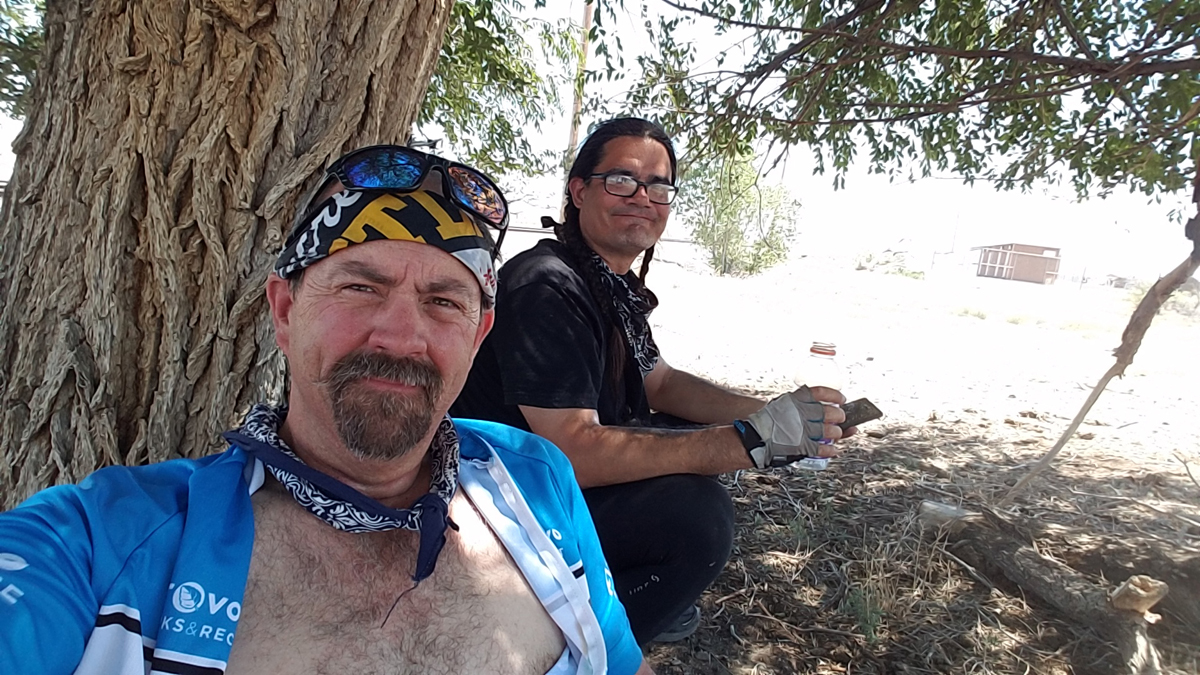
By Chris Blinzinger and John Monroe — John and I like to do a couple of local tours every year and have open invitations to anyone who wants to accompany us on the proposed adventure. We have a Facebook group; Wasatch Overland Bike League (WOBL) for coordinating our trips and creating discussion posts about future rides and planning for current rides on our calendar. We have interest and input from our members but it usually ends up as the two of us. We have come to know each other’s habits and personalities well so we make a good partnership on tours. We have similar ideals about our ability and both understand that all plans are in pencil and subject to modification up until we arrive at our destination at the end of our tour.
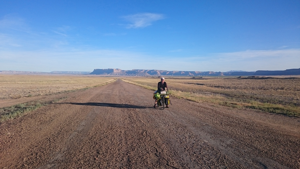
Stopping in the Desert. Photo by John Monroe
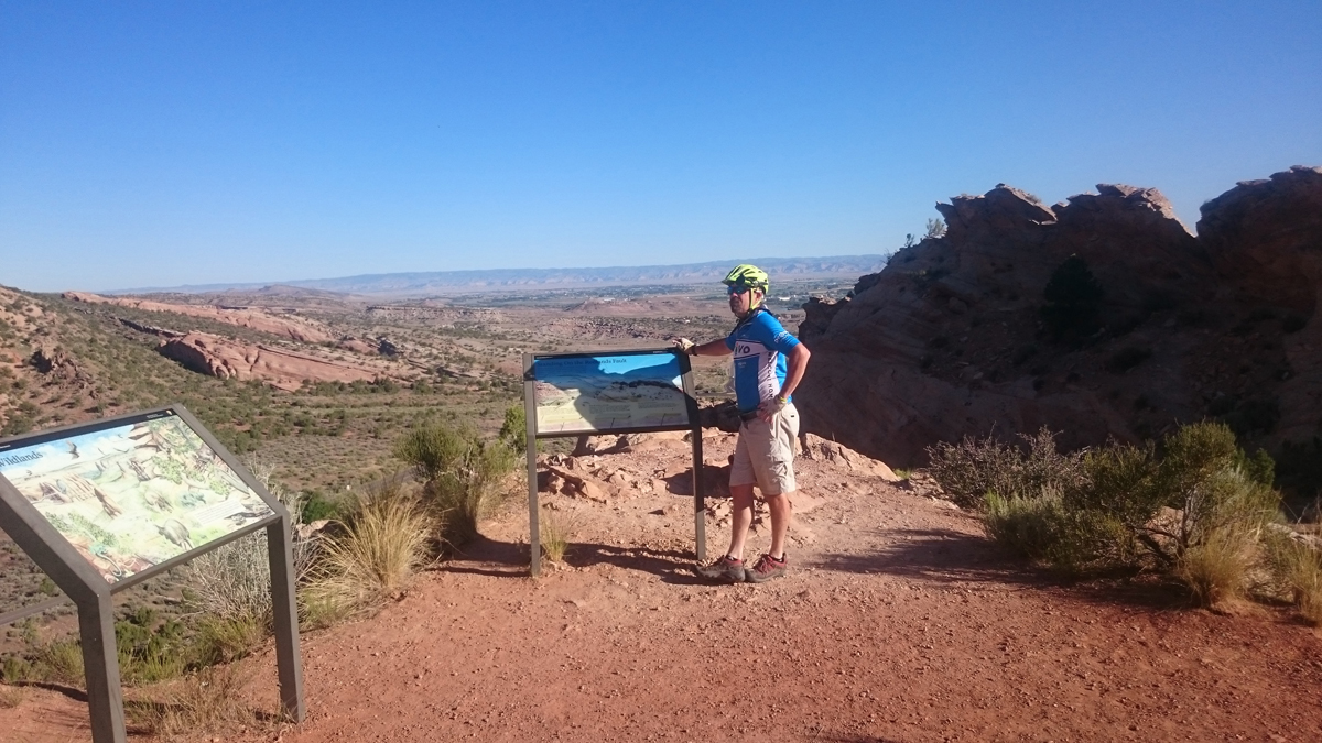
Provo to Helper, Utah
We planned to ride to Grand Junction, Colorado, the 3rd week of June, 2017. John rode the Frontrunner down to my house on the evening before our departure to go over final planning and meet with Paul who would accompany us on this ride. I always get nervous just before a trip. We headed out the following morning and met up with Paul at the Frontrunner station that we would ride to Provo to begin our journey. The benefit of using the Frontrunner eliminates a full day ride between mine and John’s house so we use is regularly to meet up for our tours.
Heading down to Helper. Photo by Chris Blinzinger
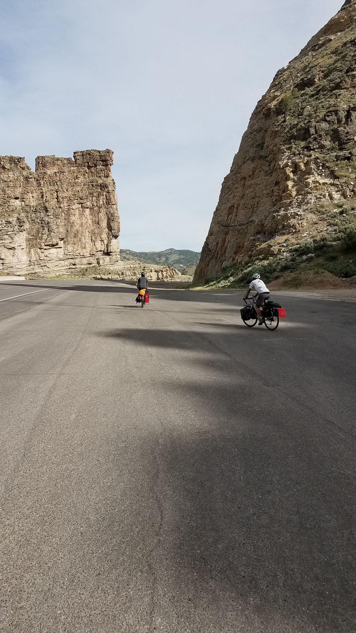
We were pedaling toward Spanish Fork Canyon by 9:00 enjoying the sun coming over the mountain and getting used to the extra weight. Spanish Fork Canyon had been one of my concerns during the planning process. The road is pretty narrow in some places while plenty wide in others. Cars are traveling fast and the narrow shoulder at the mouth of the canyon leaves little room for mistakes. We had our first flat several miles before the canyon. Flats are to be expected but they have been few and far between on our rides. I hoped this would be the case on this ride as well but we were starting off a little early.
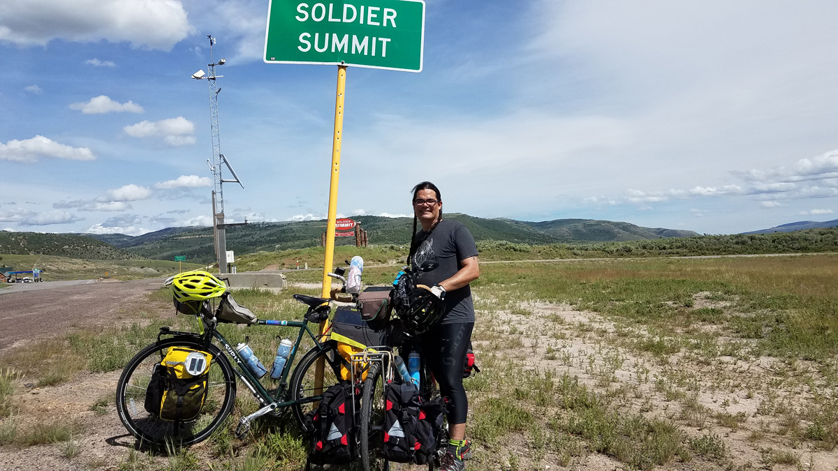
John Monroe at the Summit. Photo by Chris Blinzinger
There is a great little “Historical Railroad” rest area just before the climb to Soldier Summit. It’s a great place to rest, refill water, eat lunch and see the old trains. Our next stop; Soldier Summit. The pass was discovered in 1776 by Franciscan Priests, but it was probably used by Native Americans for centuries. It got its name when soldiers were trapped there during a storm on their way to meet the Confederate Army. Several soldiers died and were buried up there. The climb was easy. We had the assistance of an awesome tailwind to get us up the pass. About a half mile before the summit sign we stopped for a break and pictures when a motorist pulled alongside and told us that our companion was possibly lying dead on the side of the road back behind us. They observed him tangled up in his bike on the side of the road and not moving as they passed. We were concerned but assumed he was fine. We could see him a ways back riding our way. Shortly after we parked our bikes, he pulled in. When he pulled up his hands were black and greasy. He reported that his chain had come off the cassette and wedged in between his spokes. He was trying to leverage it out with putting the feet the on the rear stays pulling with all his might. He laid in the same position to rest from exhaustion. It took a lot of pulls to get it out. That is what the motorist observed when reporting our dead partner.
We ended our day in Helper. It was a fun ride down the other side of the summit. It was sketchy in several places where we had to ride on the road in the absence of a shoulder. Big trucks were barreling past us. We made good time. In Helper we ran into a Helper Police Officer and asked for a permissible place to camp. He directed us to the park nearby advising that it would suit our needs. Within a couple minutes we found a nice, grassy, shaded park next to the creek. Grocery was within walking distance to provision. It was great, the bugs weren’t bad and we had power in the pavilion to charge our electronics. We turned in early and the sound of the running water put us quickly to sleep. John and Paul had tents and I had a tarp that I drape over my bike and sleep under it. We awoke at 2 AM to sprinklers popping up underneath us. The tents were in much better shape for dealing with the sprinklers than my set-up because it didn’t have a floor. I used every bit of strength I had to push down and hold the sprinkler that was directly under me trying to minimize the damage. My bag is in a bivy so it had protection underneath but it was still very wet. The sprinkler cycle lasted 20 minutes. It was a rude awakening but once they turned off, it was back to sleep. My tarp is homemade and I was pleased that it did keep all of the water from the outside off me. Paul’s tent was least impacted because it was out of the sprinkler zone.
Helper to Green River
We continued on to Green River the next morning. Again we enjoyed a tail wind but it was hot. This tailwind was strong enough that we rarely shifted out of the “big chain ring”. Anytime that happens on a tour is a good day. Touring in the desert requires carrying a lot of water. It’s best to drink it rather than pour on your head. We carried 9-10 liters each and at times used most of it betwixt stops. We considered wild camping next to the Green River but I was feeling a bit paranoid. John was insistent that we would be fine as soon as the sun went down. He wanted to stealth camp and me and Paul wanted a shower. After my recon ride we decided on the state park and slept on the grass and had a shower.
Green River to Moab
We pedaled out on the Old Spanish Trail (Hwy 5 & 50) toward Crescent Junction. It was a beautiful, peaceful ride and was far off from the sounds of the freeway. The landscapes were so relaxing. The road was checked and rough in places but the solace of the ride trumped the road conditions. We’ve ridden hundreds of miles of dirt road on our trips so this was normal for us. Looking back at the desert we admired the colorful display the rising sun created behind us. We rode side by side with no traffic. Those opportunities are some of my most favorite. John’s pedal had been cracking and popping since the previous day hoping to make it to Moab for a replacement. He finally stopped to investigate the worsening problem and determined that his crank bolt was coming loose. That was an easy fix. Good to go and we pedaled on.
Hwy 92 from I-70 to Moab is a sketchy ride. After stopping at Papa Joe’s Stop and Go, with a 1 star Yelp review and cold drinks we pedaled intensely to get down the road and off the highway. We stopped several times to wait for Paul but he eventually told us to not wait for him. He said he would get to Moab at his own pace. Traffic was flying by from both directions. We pedaled on anxiously looking for the Bar M Trail (bike path) 10 miles north of Moab. We had a relaxing break at the Archview RV and Resort for a bite to eat and another cold drink. When we reached the Bar M Trail, we slowed to enjoy the colorful ride all the way into Moab. What a great path. We stopped in the shade at the river’s edge to contact the VFW. John is a member because of his military service. We contacted them for directions and headed into town. It was difficult to find because the phone was so hot it wouldn’t work. We stopped at a laundry for help with directions. The owner insisted on giving us cold water. She almost held us hostage until we finished the water and then offered to drive us up the hill to the VFW. They weren’t open yet but we didn’t turn down the ride. It was hot so waited in the shade until they arrived.
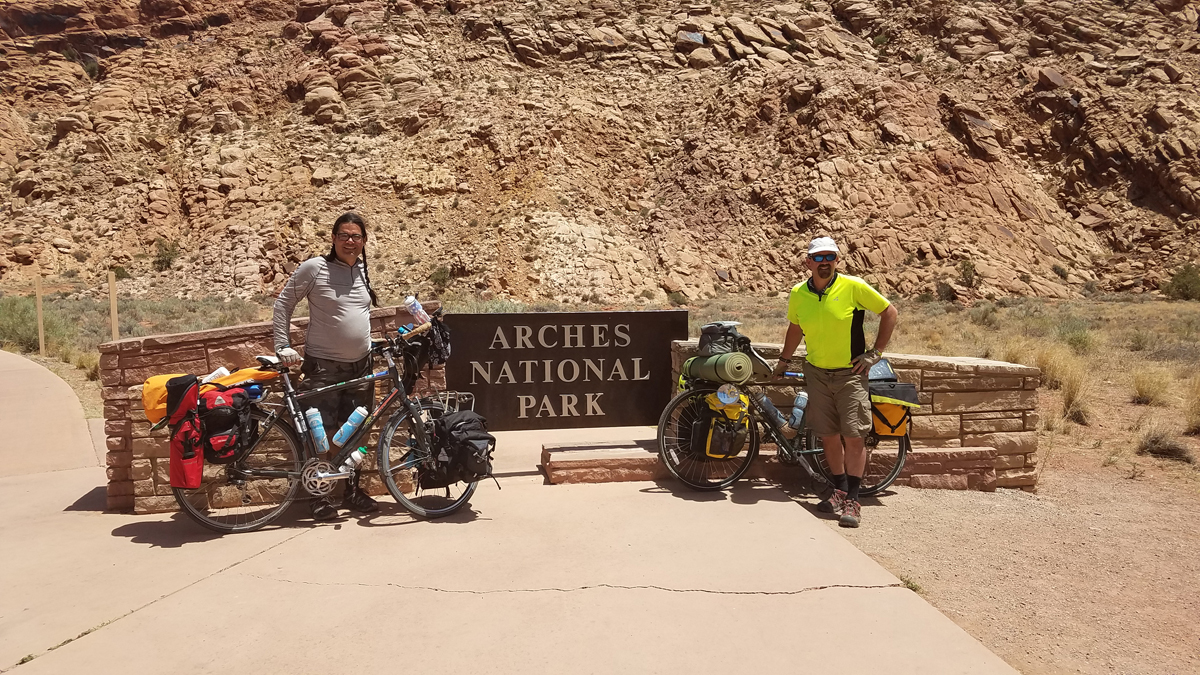
Chris and John at Arches. Photo: Chris Blinzinger
When we heard from Paul he was stopped at the airport north of Moab and decided to head back to Green River and take the bus home. He had enough of the heat and traffic. He messaged us just as we arrived at the VFW. We intended to camp in the yard of the VFW. John carries a folded up piece of corrugated plastic on his pack that is used to either flatten out the ground or use as a table or under his air mattress. It also doubles as a movie screen and we propped it up against John’s bike and used his small projector to watch Hacksaw Ridge. It was a cool relaxing evening. The guys at the VFW were great hosts and good ole boys.
Moab to I-70, Exit 221 Via Dewey and Cisco
Our route up the Colorado River was cool in the shadows of the canyon and enjoyable while we were on the bike path but eventually we ended up on the road. It was a nice ride along the river. The red rocks are amazing and provide a nice view. We stopped at Dewey Bridge which is on Utah’s Historical Registry. It was the state’s longest suspension bridge until it caught fire in 2008. There is a campground there and we pumped water out of the river to top off after we let it set long enough for the sediment to settle before filtering. We had no idea what we were in for from here.
We had plenty of water, or so we thought. It was a hot day and we pedaled toward Cisco. We had no specific destination in mind but wanted to get as far as we could on this day. We are careful about managing electrolytes on our rides and were especially careful on this hot day. It was over hundred degrees and we were losing a significant amount of salt through sweating. After hours of riding in the increasing heat, we decided to look for shade to wait for cooler weather in the evening. We were a quarter mile from Cisco when we spotted our first option for shade. We parked our bikes under a couple feeble looking trees to get out of the sun. It was still hot. The sun still broke through the sparsely arranged branches so I tied up my tarp to block the sun’s encroachment. We pulled out our mattresses hoping for a cool nap, but it was still hotter than blazes.
Our water could have made a nice tea without having to heat it. John had started our trip with an insulated bottle of ice. It was nearly depleted and wanted to enhance our warm water so we tried taking a mouthful of the warm water and adding ice to provide a cool swallow. It was better than straight warm water but there was a severe shortage of the refreshing ice. We tried to nap but the heat was miserable. There were 15 passenger vans pulling raft filled trailers past our shaded spot and creating dust. There is a put-in 10 miles southeast of Cisco. I decided to take a walk into the town just to stretch my legs when one of the van drivers told me to be careful because the folks there were not fond of strangers wandering around. There was some hand painted signs on the side of buildings that confirmed that. We hung out there for 4-5 hours.
Escaping the heat. Photo by Chris Blinzinger
A breeze kicked up and clouds rolled in which cooled things down and was blowing the direction we were heading so we packed up and headed off. We could see dark clouds in the distance and hoped that it would be some welcomed rain. We made it out to I-70 and had a helluva tailwind pushing us along. Riding the freeway is easy, wide shoulders and allows a comfortable distance from traffic. We hardly had to pedal. This was short lived though. After 8 or 10 miles the wind changed 180 degrees and blew right in our face. It was crippling wind. We had been at traveling 18-20 mph with the tail wind and now we were working so hard to get 6 mph. Boy had things changed for the worse. There was no end in sight and would learn no services until Loma. We pedaled on for another hour and found a ranch exit.
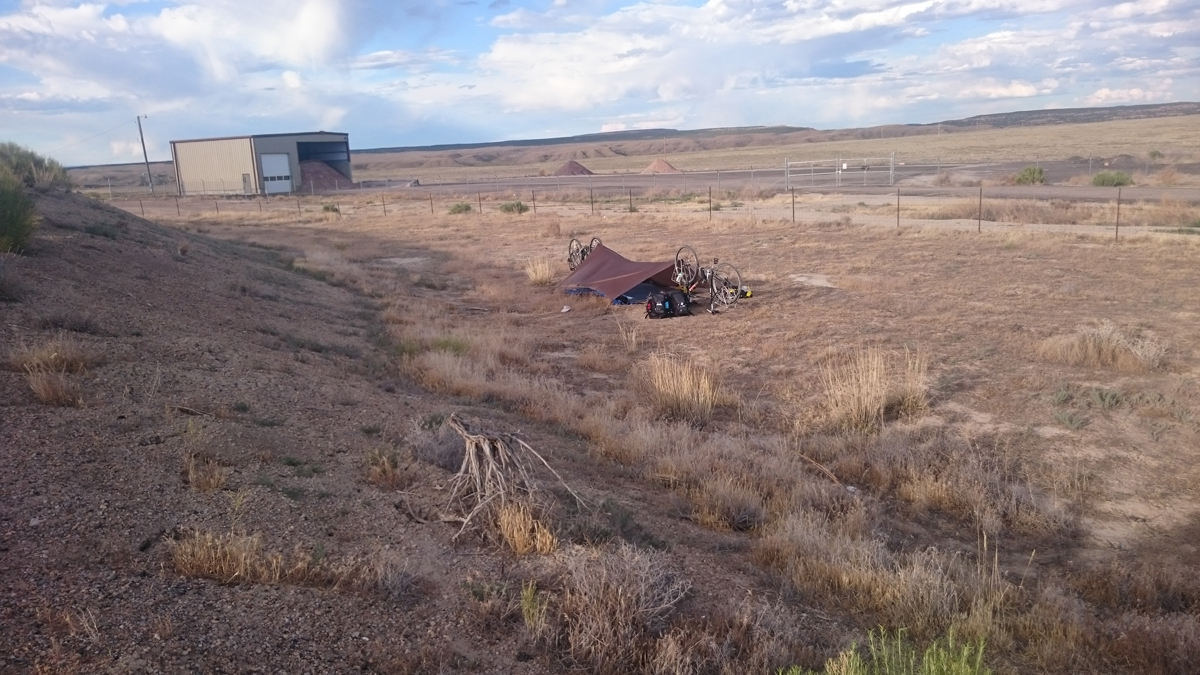
During the stop in the shade we drank more than we realized. When we inventoried our water, there was a bit of panic that our supply was severely depleted. It was bad enough that we considered not using any water for our dehydrated dinner. We set up camp on the lee side of the ramp.
That was short lived as the wind changed again and blew our whole setup down. We were chasing gear and bedding as it was carried away. Luckily the fence stopped it and we gathered it up just in time for the wind to stop. Reality of our water crisis set in.
We sat there on the guard rail feeling a bit helpless. John considered writing a sign on his corrugated plastic, “Need Water”. We were both nervous about how we would make it to the next town. I posted a status on Facebook about our dire situation. A friend from work had family in Fruita and offered to send us help. It was a generous offer. As we considered our options, we heard a vehicle coming up the ramp in the distance behind us. As we turned a semi-truck had pulled half way up the ramp and parked. Didn’t think much of it at first, but then he let his dog out of the truck and we realized that he may have water.
We walked fast toward him. It was difficult not to run, we were feeling anxious. I can’t imagine what he thought seeing 2 dirty, unshaven and unshowered vagabonds walking toward him. As we approached the truck his dog barked aggressively at us. I tried to explain our situation but my voice could not be heard over the barking. The driver looked us over with an abundance of caution and I had to yell for him to hear us over the dog. He was trying to understand but still being cautious. He got the dog calmed down and we explained our plight. He looked at us as though we had a different motive; like we weren’t telling the truth. Our camp was set up on the other side of ramp and was out of his sight. We asked for some water and offered to pay him for it. This is when he took us serious and not as a threat. I think I know what Oliver Twist must have felt like. He asked about the details of our journey to vet our story and then offered us water he had for his dog and reached into the truck. He pulled out an unopened 3 liter bottle of water. He wouldn’t take any money. He called his dog and climbed in the truck. We walked back to our camp ready for dinner. We ate like kings and it felt good to drink as much water as we wanted.
Camp at I-70 Ranch Exit. Photo by John Monroe
Exit 221 on I-70 to Fruita, Colorado
We were on the road by 5:00 am the next morning. There are a lot of hills getting in to Grand Junction. We are used to them but after a hard and stress filled previous day, it was wearing on us. We were looking forward to a huge breakfast in Mack only to be reminded that it was only a ranch exit. Our next option for breakfast was Loma. Not what I would call a savory breakfast. High sugar content, preserved convenience store food. It got us enough energy to Fruita. We arrived at the campground early afternoon and were happy to relax.
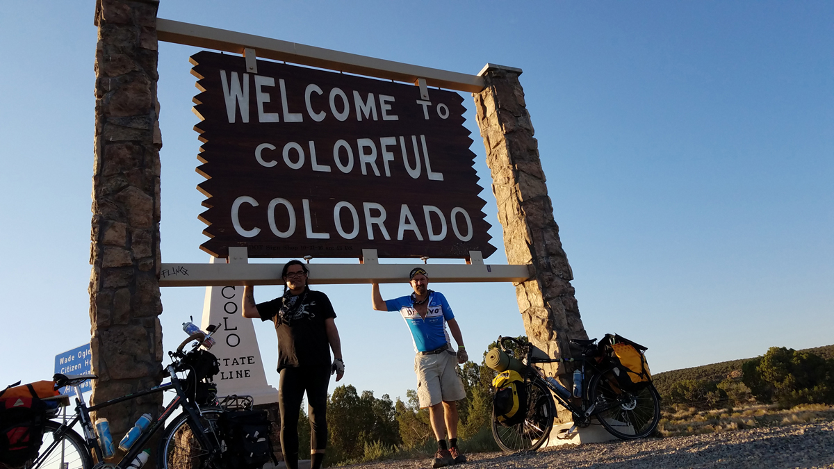
Chris and John at the State Line. Photo by Chris BlinzingerColorado Fix-a-flat Flat. Photo by John Monroe
I was welcomed to Colorado with a flat tire. We stayed at the Monument RV park. It had a shower and plenty of water and local restaurants were close by. We enjoyed another movie night and chilled out for the evening.
Fruita to Grand Junction
Our last full day in Grand Junction we had arrangements to stay at the Grand Junction VFW. We arrived and were offered the elevated stage in the game room that the band plays on to sleep. It was next to the bar and seemed to be a great option. The folks at the VFW both in Moab and Grand Junction wanted us to keep them posted on our progress when we were close. It was nice to have them poised and ready to deploy if we had problems. That was much appreciated and it gave us a feeling of security. They fed us dinner and we enjoyed good conversation. I appreciate our military men and women who have served valiantly and who continued to serve 2 scraggly bike tourists.
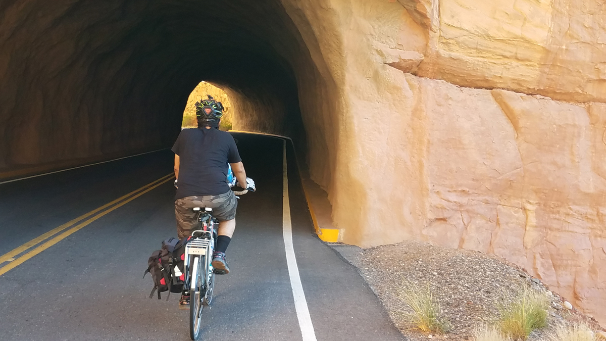
Colorado National Monument Ride
We wanted to ride through the Colorado Monument the next day just for the ride. We ended up loading our bikes in JD’s truck at the VFW who offered his back yard and was closer to the National Monument so we accepted the offer. John had communicated with JD prior to our arrival and its great that he was our trusted agent. We slept out on his back patio and started off early the next morning. The Colorado Monument ride required a good climb but since we left all our gear back at JD’s, the climbs were much easier.
Overlook at Colorado National Monument. Photo by John Monroe
This is a popular ride for local cyclists. It definitely gets your heart pumping and can be completed in a an hour or two for those training for a race. For us, we slumbered up the road.We were easily passed by grey haired cyclists on the uphill while we stopped to enjoy the sights and excellent views once it flattened out.
Tunnel at the Monument. Photo by: Chris Blinzinger
Grand Junction to Salt Lake City via Amtrak
This was our last day and had to get back to catch a train home. We took advantage of the Roll-on service provided on Amtrak. My wife and I had used it on our Pacific Coast trip and you really can’t beat the convenience. The train was delayed a couple hours but we arrived back in SLC at 2 am on Sunday morning. Our wives had to pick us up. We will use it again.
This tour was much like every other one we have completed. With its highs and lows, triumphs and challenges. But in the end, it is fun, provides great campfire stories and lets us enjoy the beauty of this awesome planet.The last few days of our ride we talked about touring in a different region than the mountains and deserts of the West. We have organized a team for the RAGBRAI. That is the ride across Iowa (about 450 miles) in July. It is a lottery system so we are hoping to get in. We have a four person team registered and will know by May 1st if we got in. It’s the next WOBL adventure and I am excited for our 4 member team. There are endless options for taking a vacation on a bike.
Trip Log:
Day 1, American Fork to Provo on FrontRunner train, then Provo, UT to Helper, UT via US-6. 70 miles
Day 2, Helper, UT to Green River, UT, 70 miles
Day 3, Green River, UT to Moab, UT 52 miles
Day 4, Moab, UT to Exit 221 on I-70, 60 miles
Day 5, Exit 221 on I-70 to Fruita, CO 30 miles
Day 6 Fruita, CO to Grand Junction, CO 15 miles
Day 7 Colorado Monument ride approximately 30 miles, then Amtrak train ride back to Salt Lake.
Know before you go:
This ride requires carrying larger than normal quantities of water because of the distance between resources. It would be best to do in the Spring or Fall. We completed this ride the middle of June last year and temperatures were already over 100 degrees in the middle of the day. There is no water between Wellington and Green River, Utah. The rest area in between doesn’t have water. Matrimony Spring is 1/4 mile up River Road from Moab and is a great place to top off your water. You can fill up/ top-off at the Dewey Bridge but must have a pump and let the sediment settle before pumping. Once crossing the river at bridge, 32 miles outside of Moab, the next water is nearly 100 miles away. I recommend carrying a total of 7-9 liters of water and pay close attention to electrolytes if traveling in hot weather. 3 liter bottles travel well and are easy to refill. Refill when ever you can. Sleeping out on the ground proved to be optimal for my comfort and did not encounter any critters. The Amtrak has a roll-on bike service. The cost is $20/bike and well worth it. They will not drop a bike off in an unmanned station like Provo. It must be a station where employees are present (Salt Lake). You will love the views and the adventure will provide plenty of stories to tell around your next campfire.
John Monroe is an all around cyclist. He is a cycling advocate and road safety nerd. He has a YouTube Channel called Pedal Traffic where he posts about cycling and road safety for all users.
Chris Blinzinger is an avid cyclist, commuter and tourer. He is a member of the Provo Bike Committee and advocate for active transportation. He tours with friends and family and hopes to ride back to his home state of Indiana in the near future.
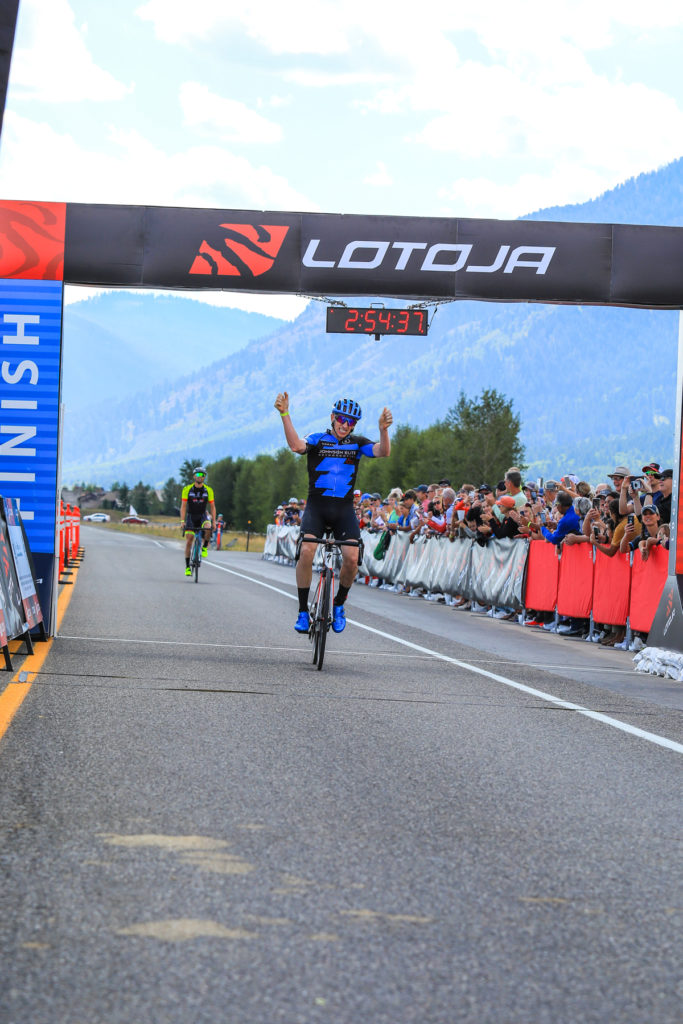
When you get older, you begin to look backward a lot more. I have over 66 years behind me and, sadly, much less than that in front of me, so I speak first hand of this. Of course, I do still look forward. Right now, for example, I am looking forward to this year’s LOTOJA, No. 30 for me, which takes place in five days.
But being No. 30 means that I have 29 LOTOJAs to look back on. I remember my first two really well. No. 1, in 1985, saw me finish in a driving rain storm, and my behind hurt so badly the last 20 miles that I am sure I spent more time out of the saddle than on it. But I had finished. I figured I had now done it, and didn’t need to do it again. So why 29 more you ask? Mmmmmmmmmmmm. Good question.
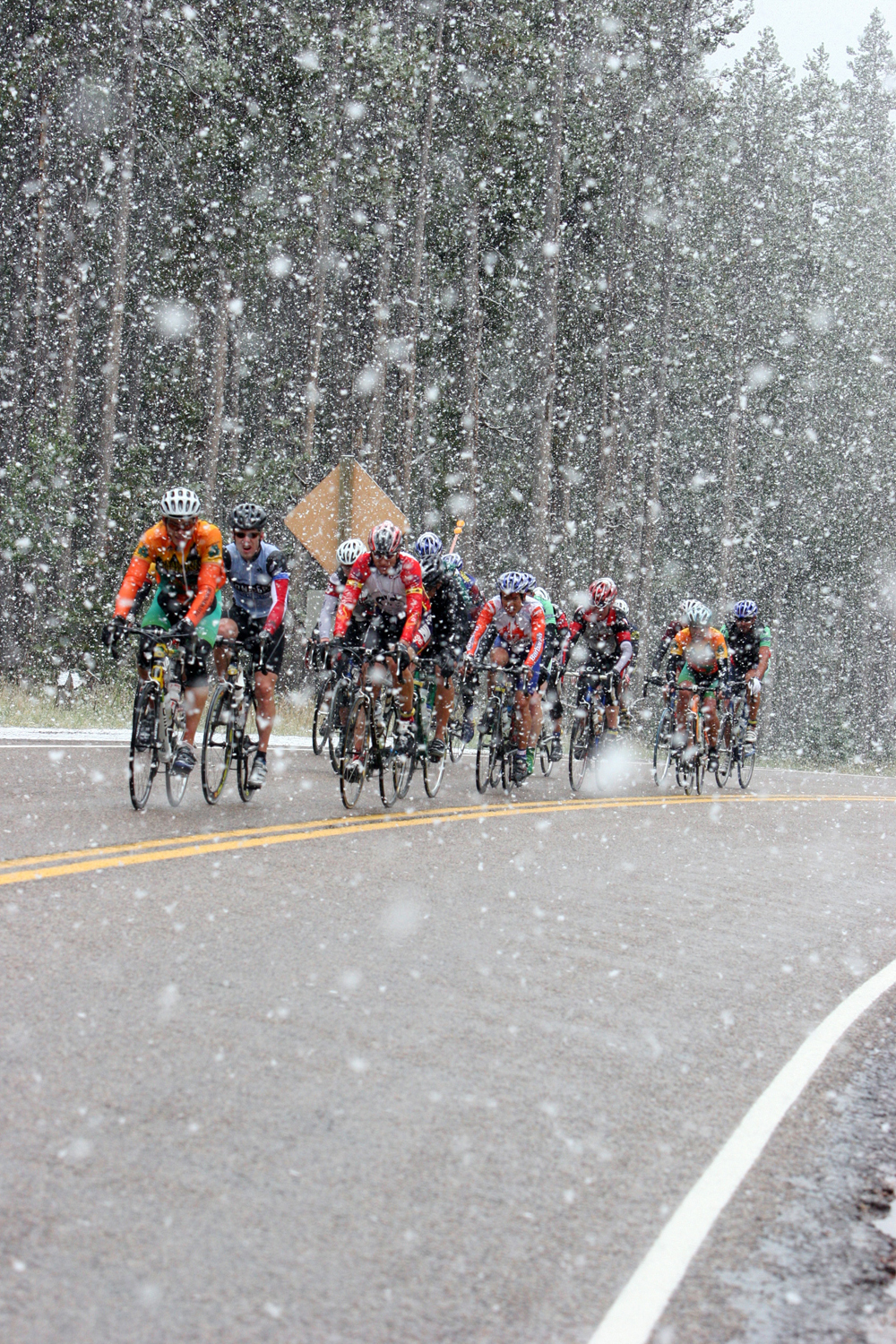
The 2005 LOTOJA was filled with snow, rain, and cold cyclists. Photo by Joaquim Hailer
No. 2 was memorable because I won my division and took 7th overall. Our group was the second to finish. We were 8 minutes behind the first group, which contained future Tour de France racer Marty Jemison. That turned out to be my best LOTOJA ever.
After that, the LOTOJAs blur together a lot. But one edition does stand out more than all the rest: The infamous 2005 LOTOJA. Promoter Brent Chambers, who has been putting on the LOTOJA since 1998, will tell those who ask about what to wear to talk with someone who rode in 2005. I was one of them.
As does everyone else, or so I thought, I was watching the weather forecast in the days leading up to race day. It was looking sketchy. I still remember the morning thereof, checking the forecast for the final time, and deciding I should dress warm and for rain. So I did, and then set off on my bike for the start line.
When I arrived at the start, I remember looking around me and wondering if my fellow racers had seen the same forecast I had. I had donned long pants, a full jacket and long-fingered gloves. Around me I saw that most had maybe a vest and arm warmers. Some had nothing extra on.
Well, the race started and by the time we reached Preston, Idaho, it was raining. By the time we had started up the canyon toward Strawberry Summit, it was getting cold and I began to see cyclists off to the side of the road. Just before arriving at the short flat about 4 miles from the summit, it was snowing huge flakes. Fortunately, though, while the snow was accumulating off the road, on the road it was melting so it was not getting slick.
My biggest surprise, however, was when I reached the summit and started down the other side. Despite my preparations, I was extremely cold. I could hardly feel my fingers. Logic told me it would be somewhat warmer once I descended, so I got into a tuck, determined to descend as quickly as I could. As I rounded the sweeping bend leaving the summit, to my astonishment I saw at least 50 cyclists walking their bikes down the road.
I was amazed. I couldn’t understand why they would be doing that. But I wasn’t stopping to ask why. I did notice that many still had little to no extra clothing on, and on later reflection, I figured that they were likely so cold they were shivering and unable to control their bikes. The one piece of good fortune for us all was that it had stopped snowing.
When I reached the lower elevations, it was a little but not much warmer. Along the way, I saw bikes leaning up against cars, homes and other buildings. I even saw an idling police car with three bikes leaning up against it. Personally, I was soaked and cold and anxious to cover the next 15 miles or so it took to get to the feed zone in Montpelier. I kept passing riders who, I could tell, were worse off than me, and likely just trying to pedal their way to Montpelier where they would call it good for the day.
At that time of my life, I still considered myself a racer. So, instead of stopping at the feed zones, I was still just grabbing a feed bag from my wife and loyal support person, Karma, as I would ride by. But this time, while she was there ready to hand off my bag, to her surprise I pulled off and stopped, telling her I needed to change into dry clothes. (Just to brag a little, I bet I was one of the few people to bring not one, but two sets of warm clothing to the LOTOJA that year. Smart me.)
She was parked on the other side of the park, so off we ran across the lawn. She offered to start the car and let me warm up awhile, but I knew I just needed some dry clothing. So, with no thought of modesty, upon arriving at the car I began stripping while she fished out my dry clothes. In the midst of doing this, Karma also told me that a board had been set up and it was announced that if a rider’s number was posted on it, his or her support was to head back on the course to find their rider.
In a few minutes, I was dressed again, dry and back on the road, with even warmer gloves than I had been wearing before. After that, the rest of the ride was comparatively uneventful. It rained off and on the rest of the race, but I was warm, or at least warm enough, and finished without incident.
I later learned that I was among the one-third of the riders who actually finished the race. I heard stories of riders suffering from hypothermia, which was no surprise to me. I think I saw about 50 of them walking down the road from Strawberry Summit.
I believe it may be been after that year that the LOTOJA was moved from the third Saturday of September to the second Saturday. Good move. Every year since then has seen decent weather.
This year, the forecast is calling for warm, dry weather. That’s good. Hopefully we will have a nice tailwind to make the ride even better. At my age, I need all the help I can get. I just hope to make it, and maybe even before dark.
Still, I’ll be taking along my warm clothing, long-fingered gloves, and water/windproof booties. I remember LOTOJA 2005 and I’ll be ready. Just in case.
America’s longest, one-day sanctioned bicycle race features 203 miles and ‘strict’ Covid-19 guidelines
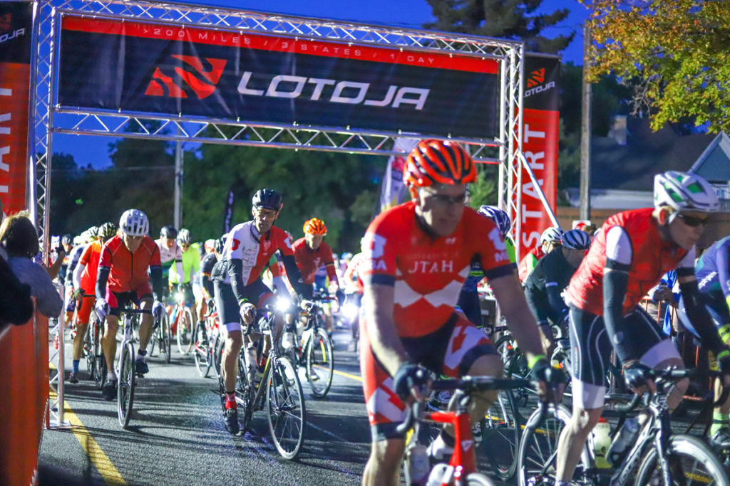
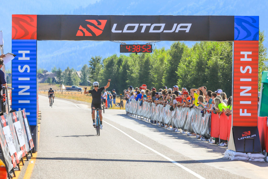
Layton, Utah — The 38th annual LoToJa Classic will depart from Logan, Utah, on September 12, 2020 with 1,250 cyclists pedaling to Wyoming’s Jackson Hole under extensive Covid-19 safety guidelines.
LoToJa begins at Sunrise Cyclery in Logan and ends at Jackson Hole Mountain Resort for licensed racers (203 miles/327 kilometers) and Jackson Hole High School for cyclosportive riders (198 miles/319 kilometers). The nearby 13,776-foot high Grand Teton greets cyclists as they cross either finish line.
Cyclists leave the start line at Sunrise Cyclery in Logan, Utah, in the 37th Annual LoToJa Classic. The race was held on September 7, 2019. Nearly 2,000 cyclists participated. Photo courtesy of Snake River Photo
Cyclists ride the entire course in one day on scenic back roads through northeastern Utah, southeastern Idaho and western Wyoming. Along the way they pedal through Utah’s Cache Valley, Idaho’s Preston and Montpelier, and Wyoming’s Afton and Alpine Junction in Star Valley before reaching Jackson Hole.
Three mountain passes that total 35 miles and almost 10,000 vertical feet of climbing are also encountered.
LoToJa is recognized as the longest, one-day USA Cycling sanctioned road race in America. After nearly 40 years of existence, it is one of the nation’s most popular cycling events with a focus on fundraising for worthy causes.
Several thousand riders from across the U.S. and foreign countries register every April, but less than 2,000 are accepted to keep safety and the quality of the cycling experience at a premium. LoToJa’s popularity is fueled by its challenging distance, scenery, and finish line in one of America’s most popular visitor destinations in the West.
Roger Arnell (Johnson Elite Orthodontics) celebrates after winning the Men’s Pro 123 race in the 37th Annual LoToJa Classic held on September 7, 2019. Arnell finished the 202-mile course in 8:45:51. Photo courtesy of Snake River Photo
LoToJa almost joined the long list of major cycling events across the U.S. that have been canceled or postponed this year due to the Covid-19 pandemic. But because of enthusiastic support from riders, sponsors and community leaders, the decision was made to run the event with strict “Covid-19 Adaptations,” said LoToJa Race Director Brent Chambers.
“Although we’re in the midst of a global pandemic, we have worked tirelessly to plan for and implement several comprehensive safety adaptations to mitigate the health risks of riders, support crews, and the communities that LoToJa passes through,” Chambers said.
“We have applied CDC and local and state health department recommendations in our preparations,” he added. “With them in place, we have done what health experts say are effective to mitigate Covid-19 transmission.”
Alison Tetrick (Specialized) acknowledges the cheering crowd after winning the Women’s Pro 123 race in the 37th Annual LoToJa Classic held on September 7, 2019. Tetrick finished the 202-mile course in 9:42:07. Photo courtesy of Snake River Photo
Chambers said it is his perspective that the “pandemic will be with us for longer than anticipated while vaccines and treatments are developed and accepted by the public. Meanwhile, we shouldn’t stop living life. We can adapt with effective health safety measures, and keep the race moving forward.”
In addition to mandatory facial masks, hygiene and social distancing, Chambers’ Covid-19 Adaptations include more than 50 specific health safety actions and requirements that further minimize human contact during LoToJa. Key points include Covid-19 screening for all cyclists, no indoor gatherings, smaller groups leaving the start line, more and enlarged feed zones to increase social distancing, and all neutral feed zone staff to wear PPE and distribute food and hydration products to cyclists from behind protective barriers. Hand sanitizer will also be everywhere.
Cyclists are allowed to remove masks while on the road. A complete list of the Covid-19 Adaptations, along with other event-related information, can be viewed at www.lotoja.com.
Chambers said this year’s LoToJa is essentially two events in one. The change significantly reduces the number of cyclists and support crews at the start line, on the road, through communities on course, at feed zones, the two finish lines, and at the awards ceremony. The start line area has also been enlarged to further increase social distancing between riders.
He said the success of this year’s event is dependent upon the choices and cooperation of every cyclist and his or her support crew to follow the Covid-19 Adaptations. That includes volunteers, vendors and sponsors, too. He stressed the effort is about creating a great experience for everyone, not just a few.
“LoToJa is committed to do whatever it takes to keep everyone as safe as possible,” Chambers said. “Likewise, we expect all participants to follow all event guidelines.”
Those who don’t will be disqualified and potentially banned from future LoToJa’s, he said.
The men’s and women’s course records weren’t broken during last year’s race due to strong headwinds. Spencer Johnson’s winning time of 8:18:29 in 2018 took more than 24 minutes off the previous men’s course record of 8:42:31 that was set in 2017. The women’s course record of 9:35:00 was set in 2013 by Melinda MacFarlane.
Most other cyclists take 10-13 hours to ride LoToJa, with some coming in as late as 8:30 p.m. when the finish line closes. But despite pedaling all day, many return every year.
LoToJa began in 1983 by two Logan cyclists who wanted to create an enduring one-day bicycle race. They modeled it after European professional cycling’s five grand monuments: Milan-San Remo, Ronde van Vlaanderen, Paris-Roubaix, Liege-Bastogne-Liege, and the Tour of Lombardy.
In LoToJa’s first year, seven cyclists competed and crossed the finish line near downtown Jackson. The winner was Bob VanSlyke of Logan who finished the 186-mile course in 9 hours. In 1986 the finish line was moved to Jackson Hole Mountain Resort, which pushed the race’s distance to over 200 miles.
Since then LoToJa has become one of America’s premier amateur cycling races. It has also become a major fundraiser for the Huntsman Cancer Foundation and other health-related organizations. More than $2 million has been contributed to Huntsman alone by cyclists and sponsors. LoToJa also sponsors local fund-raising groups that assist the event.
Chambers said this year’s LoToJa again features multiple categories for USA Cycling license holders, plus a cyclosportive rider class, which consists of non-licensed cyclists who are either competing against riders within their age group, or are just riding for fun. A relay race and categories for tandem riders are also held.
This year’s race will have 600 course volunteers, which includes 125 Ham radio operators from the Bridgerland Amateur Radio Club, he said. They provide uninterrupted communication throughout LoToJa’s mountainous and remote terrain.
Chambers stressed LoToJa wouldn’t be possible without its volunteers and the cooperation and assistance it receives from businesses, civic leaders, public safety officials and community volunteers.
He also emphasized that LoToJa’s top goal is to have a safe race for all cyclists, support crews and volunteers. Motorists traveling on LoToJa’s course on Sept. 12 are asked to use caution when approaching cyclists. Groups consisting of several riders may be present.
To further increase safety on race day, the Idaho Transportation Department will restrict eastbound traffic on state Route 36 north of Preston between Riverdale and Ovid from 6 a.m. to 12 p.m. Eastbound traffic on US-89 between Montpelier and the Wyoming state line will also be restricted from 8 a.m. to 2 p.m.
The temporary travel restrictions are used to add an extra layer of safety for cyclists, Chambers said. Motorists are asked to use caution while traveling on these two roadways during LoToJa. Cautious passing is advised to ensure safety for everyone.
Chambers defined “cautious passing” as slowing down, giving at least three feet of space between the vehicle and cyclist(s), and patiently waiting for oncoming vehicle traffic to clear before pulling around a cyclist or group of cyclists.
LoToJa cyclists, plus their support crews, well-wishers, event staff and volunteers, represent an entourage of approximately 3,000 people, Chambers said. Several of the communities through which LoToJa passes organize roadside fundraisers to capitalize on the influx of visitors. The host cities of Logan and Jackson also enjoy a welcomed economic boost from the race, specifically restaurants and hotels.
According to Chambers, it is estimated more than 20,000 cyclists have pedaled more than 6 million miles during LoToJa since the race began 38 years ago.
“After all these years, LoToJa is still a remarkable event that touches the soul of everyone who races or rides it,” Chambers said. “To cross the finish line is an achievement that not only enhances people’s lives — it changes them for the better. Who wouldn’t after riding 200-plus miles in a day across some of the most breathtaking landscape in the American West? LoToJa is about celebrating life and the power and resilience of the human spirit. In times like these, we need to be reminded of that.”
LoToJa’s route and additional information about the race are available at lotoja.com.
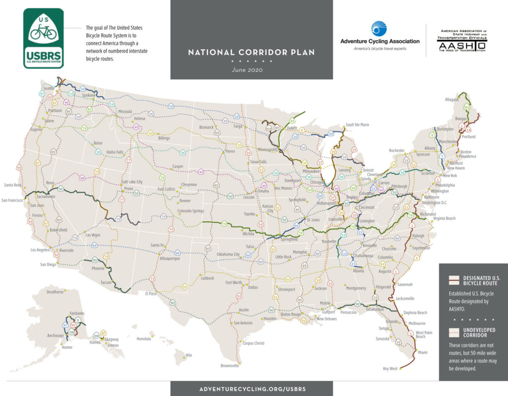
MISSOULA, MONT., Sept. 3, 2020 – Adventure Cycling Association is proud to announce the designation of the first U.S. Bicycle Routes in Wisconsin and California, expanding the reach of the U.S. Bicycle Route System (USBRS) to 29 states. In Wisconsin, USBR 30 and USBR 230 utilize several off-road trails to connect Milwaukee to the Mississippi River at Bluff Siding. In California, USBR 50 connects Lake Tahoe and the existing USBR 50 in Nevada to the San Francisco Bay Area. Together, they add over 500 miles of new routes to the USBRS.
Map courtesy Adventure Cycling Association.
“The COVID-19 pandemic is challenging everyone to find new and creative ways to spend their recreation and vacation time,” said Jim Tymon, American Association of State Highway and Transportation Officials (AASHTO) executive director. “Many people have turned to the bicycle for daily commuting, recreation and tourism. State departments of transportation are committed to providing more travel options to get people where they want to go. And with the addition of U.S. Bicycle Routes in California and Wisconsin, there are now 29 states that are part of the USBRS, which is connecting communities both large and small and urban and rural.”
The USBRS is developing a national network of officially recognized, numbered and signed bicycle routes. All U.S. Bicycle Routes are designated by AASHTO. With the new designations, the USBRS now boasts 14,598 miles of routes in 29 states and Washington, D.C. At least 40 states are currently developing U.S. Bicycle Routes.
Digital maps for all designated U.S. Bicycle Routes are available to the public for free, thanks to a partnership with Ride with GPS, from the Adventure Cycling website.
Adventure Cycling Association, a nonprofit organization that provides national coordination for the U.S. Bicycle Route System, partners with AASHTO to ensure states have the resources and expertise needed for successful route designation.
Wisconsin
In Wisconsin, USBR 30 begins in Milwaukee, at Lake Michigan, and ends in Bluff Siding, on the Mississippi River. The 269-mile route uses multiple types of existing bicycling infrastructure, including state and county bike trails, local roads and bike paths, and state and county highways. Wisconsin also announces the designation of USBR 230, a 40-mile alternate route that provides routing directions for use when the Merrimac Ferry (Colsac III) is not in operation.
“Establishing this route has been years in the making and it’s a great accomplishment for the state,” said Craig Thompson, Wisconsin Department of Transportation (WisDOT) secretary-designee. “More than 70 communities in 11 counties worked together to create this great transportation corridor that will be enjoyed by local, regional and national bicyclists.”
USBR 30 and USBR 230 showcase many natural and cultural resources across the state, including forests, vibrant urban areas and the meandering Driftless Region. Together the two routes guide bicyclists through more than 160 miles of Wisconsin Department of Natural Resources (WisDNR) state and county trails, including the Glacial Drumlin State Trail and the Elroy-Sparta State Trail.
“More than half of USBR 30 is made up of our state bike trails,” said Preston Cole, WisDNR secretary. “This new route gives bicyclists detailed directions to navigate across the state, providing yet another way to experience our great outdoors.”
In California, USBR 50 begins in South Lake Tahoe, at the Nevada border, and ends in San Francisco. The 233-mile route climbs across the Sierra Nevada, winds through the Sacramento Delta and traverses the Bay Area. It incorporates a ferry across the San Francisco Bay and provides a seamless connection to USBR 50 in Nevada.
Leaving South Lake Tahoe, USBR 50 climbs over several mountain passes and follows the Mormon Emigrant Trail Road, featured in the 2018 and 2019 Tours of California. In El Dorado County, USBR 50 utilizes the popular El Dorado Trail. This paved rail trail segment treats cyclists to a restored railroad trestle 200 feet above Weber Creek.
From Folsom to the state capital city of Sacramento, USBR 50 utilizes the Jedediah Smith Memorial Trail, providing over 30 miles of car-free cycling.
Continuing to the west, USBR 50 passes the Peña Adobe, located within the 470-acre Lagoon Valley Park. Built in 1842, Peña Adobe is the oldest structure in Solano County. Cyclists on USBR 50 can take in the scenic vistas of the Suisun Marsh, one of the largest freshwater ecosystems in California, before dropping into the greater San Francisco Bay and enjoying the waterfront views.
From the “California Alps” to the agriculture of the Central Valley, from the Sacramento River Delta to the San Francisco Bay, USBR 50 illustrates the diversity of natural beauty within California.
“USBR 50 in El Dorado County not only provides a scenic bicycle route over the Sierra Nevada but also
connects the largest communities in our county,” said Mike Bean, Friends of El Dorado Trail board member. “Long term, I hope we can improve USBR 50 to serve not only visitors to the county, but local residents cycling for recreation, biking to work, and running errands by bike.”
With the designation of USBR 50 in California, the USBRS is now only one state away from a complete coast-to-coast U.S. Bicycle Route connection. A future connection across Colorado will one day make this seamless routing possible.
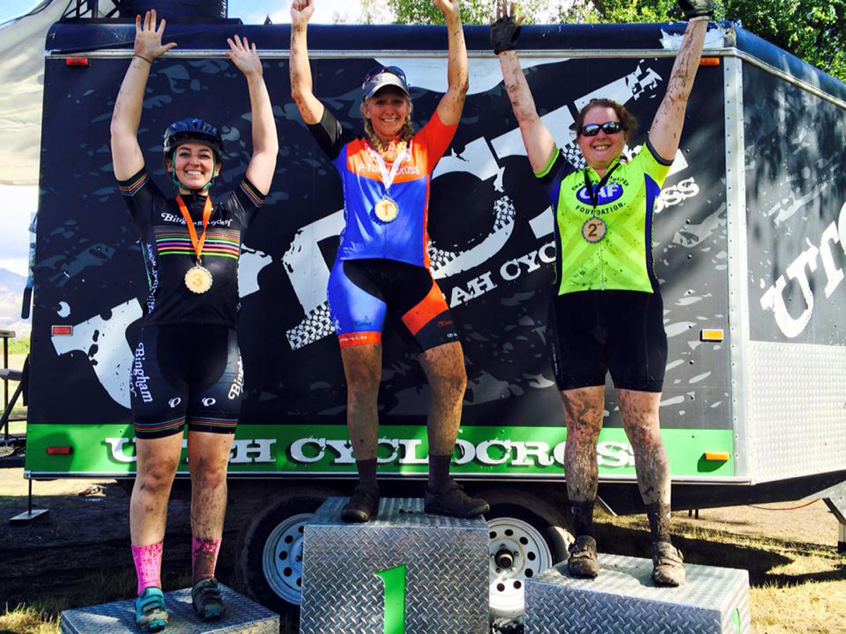
By Kelly McPherson — At the end of the cycling season, here in Utah and throughout the west, there is something glorious called cyclocross. I believe that this race was invented for cyclists who are tired from a long summer season of road and mountain racing, but who are not quite ready to hang up their bike and hop onto a trainer or spin bike. Cyclocross or CX is often seen as much-deserved playtime.
Kelly McPherson racing at the Santa Cross held at the Draper Cycle Park on December 10, 2017. Photo by James McPherson
Cyclocross is a unique race where cyclists ride an off-road looped course taped off by the director. The course will take them around turns, up and down small hills, through mud pits and has at least a few obstacles that force cyclists to get off and carry their bikes over logs or even up stairs. The participants all start together, though some may start in front based on points in the series or rankings. These are called “call ups.” This puts the faster racers in front where they don’t have to struggle so much to get around slower racers. The participants will ride for a set number of minutes and complete as many laps as they can during that time. If a racer gets lapped by the lead riders, then that racer may not do as a many laps as the others. The winner rides the furthest that fastest.
I decided to give the Utah Cyclocross Series a try this year. It looked like fun, but I was really nervous because I don’t have a cross bike. I just have a mountain bike, and not a super nice one at that. I reached out to the race director and was assured that I would be just fine on whatever I rode.
The first race in the series that I was able to get to was held at the Weber County Fairgrounds in Ogden, Utah on a cold, wet day, making the course super muddy. I don’t think I have seen a happier bunch of cyclists. Apparently as far as cyclocross races go, the sloppier the course, the happier the CX racer.
I lined up with the other girls. There were three of us in the newbie group. We were all new. This was the first race for each of us and we were all at least a little nervous. Before they started us, the kiddie-cross participants finished their race. This is the cutest race ever where the young children of the racers pedal or balance bike their way around a part of the course. My mother’s heart was grinning from ear to ear!
Finally, we got to start and it was so much fun! I rolled off across the grass towards our first set of obstacles, a set of low wooden barriers. If a racer is really good, they can bunny hop over these. An experienced racer will swing one leg over their bike, take a step or two as they deftly lift their bike over the barrier and then a step or two and they will be back on their bike without hardly even slowing down. I am not a really good or experienced racer, so my technique over those was somewhat less than effective. I still need to practice this one.
The race director had nicknamed this course Logzilla and I soon found out why. Some of the obstacles were large logs. When I say large logs, I mean really large, high as my waist large logs. I wasn’t sure how to get over these. The juniors who were racing at the same time as us seemed to be able to hop off their bikes and take a couple of steps up and over these giant logs and then they were over and on their way. To this day, I still don’t know how they did this. I, on the other hand, had a completely different and much less graceful approach. I tried a couple of different methods. I didn’t like any of them. At one point, I straddled the log and attempted to hoist my monstrously heavy bike up and over and got stuck on top with my bike mostly on top of me. I think three juniors passed me like little deer leaping through the forest as I was high centered like a hippo on a rock in the savannah. Ugh! In succeeding laps of the course, I learned to throw my bike over the log first and then crawl over. It wasn’t quick, but at least it was over.
There was a lot of mud on this course. This mud was very much to my advantage as I was able to plow right through it without any problem while some of the others on less knobby tires had to be a little more cautious or risk landing in it, rubber side up. I soon found that my mountain bike was better suited than a cross bike on muddy and/or technical courses such as this one or the Godfrey Trucking course later in the series. Because of this, I managed to place second in this race. I managed to crash my bike at the Godfrey Trucking race due to my own stupidity and a desire to get ahead of someone who I thought was going slow. I missed a couple of races because of the injury, but was happy to return for the last couple of races.
Kelly McPherson on the podium (right) at one of the Utah Cyclocross Series events. Photo by Marek Shon
I competed in quite a few of the Utah Cyclocross Series this last year and had a ton of fun at each one. Each course was slightly different and offered new challenges, new adventures, and new cycling puzzles. I would really like to participate in this kind of fun again this fall.
As I look forward to this year’s season of racing, I am planning lots of new adventures including everything from weekly crits to Crusher in the Tushar to Seattle to Portland and hopefully ending with a successful Lotoja. I am going to work hard to earn the much-deserved playtime of challenging and hopefully muddy cyclocross racing. That was just too much fun to miss!
On Wednesday, August 26, at the 2020 Utah Outdoor Recreation Summit, the Bridger Bike Park “Jewel of Northern Utah” was recognized on a grand scale as the 2020 Utah Outdoor Recreation Grant (UORG) Project of the Year.
Photo courtesy Bridger Bike Park/Cache Trails Alliance
A legacy of the collaboration of visionaries, the BBP is the realization of a grassroots effort that combined the efforts of enthusiasts, Logan city Parks & Rec, and local patrons & businesses that supported the fundraising efforts of Cache Trails Alliance, a local 501(c)(3) non-profit.
Funds raised by CTA were then matched by Logan City, and the dream was further supported by grants from Cache County RAPZ funding and the Utah Office of Outdoor Recreation.
Specific recognition & appreciation goes to Dayton Crites, former Cache County Trails Planner; Russ Akina, Logan Parks & Rec Director; Logan mayor Holly Daines & former mayor Craig Peterson. CTA fundraising organizers Tim Wolford & Sandra Escareno and their team; the leadership team at CTA: Paul Gibbons & Paul Richins; and the generous donors, both small and large, that had a hand in bringing this project to fruition. Additional sponsor support was provided by Sunrise Cyclery, Speed Mountain, Jagaloon.com, Joyride Bikes, Al’s Cyclery, & many others.
A local 501(c)(3) non-profit, Cache Trails Alliance was involved from the beginning with project design & community input, and maintenance support.
By David Collins — Ride 100 Miles or More in One Day – Entry Points in Utah. Rides Include Some Miles in Border State(s).
[Editor’s note: This article is the third part of a series, to see the first two, check out the 2019 March and July issues.]
Utah and her neighbor states are blessed with iconic geography and interesting diversions. Although these rides include stunning scenery, they often feature hidden gems and forgotten highways and byways – a cyclist’s dream – filled with unforgettable imagery, points of historical interest and quirky pit-stops.
Extended shoulder seasons are usually the best time of year to ride most of these routes, but depending on your skills and equipment, you might be able to ride nearly year-round. Be weather aware, riding conditions can swiftly change.
A scene from the Nevada ride. Photo by David Collins
Excursions and explorations are part of the fun of unsupported bicycle touring at your own pace. Mileage estimates are approximate and may vary depending on your tracking system and whims of the ride. Be sure to tell someone your plans and allow them to track your location using a smartphone or other device.
Solo or unsupported distance cycling often presents potentially dangerous situations related to terrain, weather, equipment, traffic, navigation and mental awareness. Even experienced cyclists must plan carefully and use wise judgment to successfully mitigate inherent risks of the sport or terminate a ride before it turns injurious or deadly. If you are new to the sport, or have never ridden a bicycle 100 miles in a single day, learn the ropes with a seasoned buddy or local riding club before giving one of these routes a go.
Make sure to check maps, plan your route and check local road conditions before you go. As with any ride, be aware of your surroundings and of roadway traffic.
Time to fill water bottles, stuff gear bags, click in and start pedaling Utah’s great border century rides.
Arizona
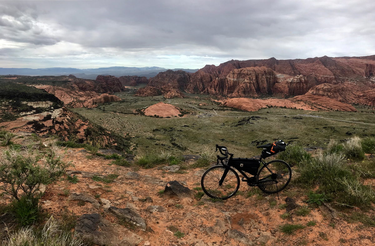
Mountains to Desert; Utah and Arizona (with a dash of Nevada at the end)
Route: Enterprise, UT; Veyo, UT; St. George, UT; Snow Canyon State Park, UT; Ivins ,UT, Shivwits, UT; Littlefield, AZ, Mesquite, NV. Begin in Enterprise, south on 18 through Veyo to St. George, west on W. Snow Canyon Parkway and north on Snow Canyon Drive to its terminus (through Snow Canyon State Park). Return the same way out of the park and ride through Ivins and turn West on W. Highway 91, South on Old Highway 91 through Littlefield AZ to Mesquite NV.
Rim view of Snow Canyon from the Arizona ride. Photo by David Collins
Terrain: Mountain passes, rural farmlands, remote Native American lands, long steady climbs and descents, small towns and villages.
What to See: Just south of Enterprise you’ll see signs for the Mountain Meadows Massacre memorial site, be sure to take a few minutes to walk the short path up to the overlook and read about the 1857 tragedy; the rim of Snow Canyon, turn west at the road sign and take the short gravel road to the overlook; a stunning detour through Snow Canyon (including a memorable 1,000 ft. four mile climb); a show stopping curtain of red mountains, best viewed in the Shivwits Paiute Indian Reservation by turning around often during the long climb toward Arizona border; miles of Joshua trees and desert sagebrush throughout much of the long descent into Littlefield, Beaver Dam Mountains; dry wash beds of various creeks and rivers; Virgin River bottoms.
Selfies and Photo Ops: Mountain Meadows Massacre overlook; Snow Canyon from the rim and through the valley; Veyo Pies storefront; historic pioneer buildings and museum in Santa Clara (a brief detour you may want to explore if you are into regional history); Bulldog Pass sign; long road pointed northward toward the wall of red mountains in the Shivwits Paiute Indian Reservation; Scenic Joshua Tree Byway sign with miles of Joshua trees in the background; Beaver Dam Wash National Conservation Area; Virgin River bottoms overlook just outside of Mesquite.
Best Post-Ride Eats: Check into CasaBlanca Resort and Casino, clean up and pay a visit to Katherine’s of CasaBlanca (will reopen May 15, 2020). USDA Dry Aged Prime beef from Stockyards in Chicago awaits, along with Florida stone crab flown in from the keys (when in season). Get things started with fresh Oysters Rockefeller. For the steak, get the strip. Wrap things up with Bananas Foster and a long night’s sleep in your nicely chilled room, a luxury after so many miles in the sun.
Still Have Legs, Lungs and Sunlight? Just past Shivwits, turn north on Gunlock Road and ride to Veyo and back (29 miles). A fabulous ride through sometimes lush farmland, past Gunlock reservoir and a lovely climb from the river bottoms up to another rural shelf and into Veyo. Be sure to stop by Veyo Pies again (surely you dropped in the first time through Veyo) and eat some of their world famous pie, I recommend the strawberry rhubarb. Pie and barbeque in a tiny roadside joint? The proprietors must have a spot or two of cycling in their souls.
Note: This ride begins in moderate mountain terrain and finishes in the desertscapes of northeastern Arizona, with and a handful of miles in Nevada. Pay careful attention to weather forecasts and be properly armed with sufficient hydration and nutrition. Also, be aware of flashfloods – water levels on local roadways can sometimes rise to dangerous levels in minutes of even seconds.
Nevada
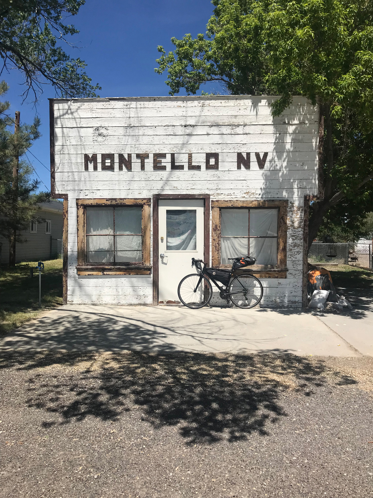
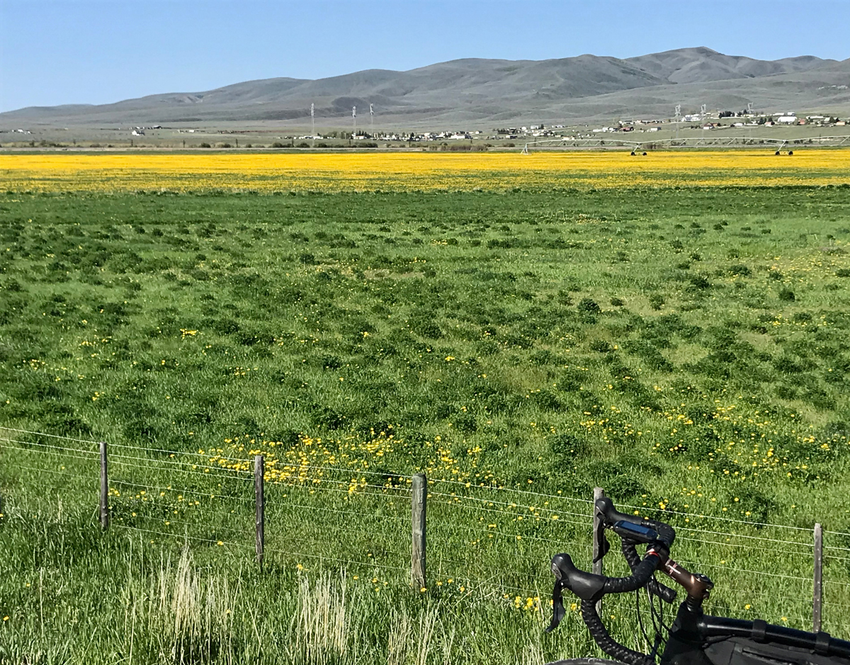
Go West! Utah and Nevada
Route: Snowville, UT to Montello, NV (one way). From Snowville, take N 18575 N (a gravel frontage road) west for a couple of miles until it joins the paved Highway 30. Ride west on Highway 30 until you reach Montello. 106 miles
A scene from the Nevada ride. Photo by David Collins
Terrain: Periodic patchwork of sage brush, grassland and cultivated farmland, rivers, creeks, expansive valleys lined by plateaus, risers, and alpine mountains.
What to See: Long stretches of road through valleys you’ll want to return to with a cinematographer to try and capture the essence of the place; open cattle ranges; alpine peaks on the horizon; northwest finger of the Great Salt Lake (including salt flats and watershed boundaries); skyline view of Antelope Island from the rarely seen or photographed west side; Pilot Peak (often snowcapped through much of the summer).
Selfies and Photo Ops: Next Services 102 miles sign; black metal silhouette of wolf howling on top of mountain butte; 27 Ranch gate; Coldwater Ranch gate; Welcome to Park Valley and nearby Park Valley Cemetery gate; Montello Rd. sign (a faded little wooden sign about a mile or two before town; Leenaz She Cave and bottle garden; several road-to-infinity backdrops along the way; old west façade whitewashed building with distinctive MONTELLO NV letters above the door.
Wildlife: Antelope, rabbits, coons, deer and elk, snakes and lizards, birds of prey, waterfowl, and buzzards.
Best Post-Ride Eats: Montello is charming but tiny and the kitchen in the bar never seems to be open, but there is one reliable food option: the Montello Gas and Grocery, serving soda pop, hot coffee, cold beer and snacks. Get some beef jerky, Frosted Flakes, cold milk and a loaf of white bread and mustard so you can wrap a few sticks of jerky dabbed with mustard to go with Tony the Tiger’s treat. Or, tough out 50 more miles to Wendover, Nevada where you’ll find all the casino food you can handle. If you do this ride in reverse and land in Snowville, there is a much better choice for dinner. Step into the Ranch House Diner, find your way back to a booth by the antique saddles, next to the fireplace and underneath the trophy elk head with a unique starboard antler. Then dive into The Trail Boss (a 16 oz rib eye – “hand cut, marinated and never frozen”). For a smaller serving try their Rattle Steak Sandwich and fixins – a tasty supper.
Still have Legs, Lungs and Sunlight? Fuel up and turn your wheels towards Wendover, about 50 miles down the road on the Utah border. After a nosh at one of the fern bars, check into a small-town casino, store your bike, take a hot shower and try your luck at the roulette wheel.
Notes:
This is a remote ride and cellular service is weak or nonexistent during the last 20-30 miles until you reach Montello. In addition to your normal tools and supplies, be sure to plan ahead by taking sufficient food and hydration since there are no refueling stops along the way.
Also, believe it or not, Montello has accommodations. The Pilot Motel features about a dozen clean rooms with AC and Free TV. Rooms can be booked through Montello Gas and Grocery. Call ahead though, you can’t check in past 7:00 PM on weekdays or 5:00 PM on weekends (hours may change based on whims of the proprietor). Why not stay overnight and turn your century ride into a back-to-backer by returning to Snowville the next day?
Colorado
Dinosaur Drive; Utah and Colorado
Route: Roosevelt UT; Vernal UT; Jensen UT; Dinosaur, CO; Rangely, CO. (with a detour through Dinosaur National Monument UT). From Roosevelt, east on Highway 191 to Vernal, east on Highway 40 to Jensen, north on S 9500 E to Quarry Entrance Road which takes you into Dinosaur National Monument (UT), take the seven-mile road in the park and return the way you came – back to Jensen. Continue east on Highway 40 to Dinosaur, CO, then south on Dinosaur Diamond Prehistoric Highway to Rangely CO. 101 miles.
Terrain: Low-grade risers and intermittent flats with arroyo undulations sprinkled throughout.
What to see: Rivers (Uintah, Green, Yampa, Rio Blanco); distant mountains (Uintas, Blue Mountain); Dinosaur National Monument north of Jensen. The seven-mile ride in the park is worth the effort and nominal entry fee and includes stunning views of dramatic cliffs, the Green River and easily accessible ancient Native American petroglyphs and pictographs; big western sky country; Rangely Auto Museum (seasonal hours); Chevron oil country including a few outbuildings littered across the empty valley between Dinosaur and Rangely, active oil pumps, drilling and wells; Rocky Mountain Cannabis store in Dinosaur (if that’s your thing).
Selfies and Photo Ops: Welcome to Roosevelt – Energy Hub of Utah sign on the east side of town; Musket Shot Springs overlook (between Jensen and the Colorado border); Split Mountain and ancient Native American petroglyphs and pictographs in Dinosaur National Monument; the giant dinosaur in the front yard of the town hall in Dinosaur; Rocky Mountain Cannabis sign in Dinosaur; several out buildings and abandoned structures throughout (think ghost town), Rangely School District bald eagle mural on the north side of the building; and Rio Blanco river crossings.
Wildlife: Bald eagles and other birds of prey, buzzards, ducks, geese, pelicans, elk, deer, fox, coyotes, trophy fish, black bears, mountain lions, badgers, porcupines, snakes, jackrabbits, raccoons, mountain goats, pica and other little grounders.
Best Post-Ride Eats: For such a small village, Rangely offers a surprising selection of eating options. After a long ride over the border though, it’s hard to beat the T-Bone Steak Ranchero at El Agave Mexican Restaurant. Ask them to add a few jumbo prawns to go with your hot tortillas, rice and beans that come with the steak and wash it all down with a cold drink from their full-service bar.
Still have Legs, Lungs and Sunlight? Turn north on Highway 191 in Vernal to Steinaker State Park where you can cool off in pristine blue waters and enjoy more sandstone and desert landscapes. (about 15 miles there and back).
Notes: The Welcome to Rangely sign brags: Way Outside of Ordinary. It’s true, it doesn’t take long to realize the ride continually evolves into a uniquely rugged and remote region after you leave Jensen. Bring extra hydration, sun protection and mechanical equipment. Also, consider scheduling your ride to overlap the annual multi-day Northern Ute 4th of July Pow Wow activities (east of Roosevelt at Fort Duchesne) where you’ll find folks from more than 15 states and Canada celebrating Native American cultures with dance, music, food and contests.
Idaho
Plymouth to Pocatello; Utah and Idaho
Route: Plymouth UT; Malad City, ID; through southern Arbon Valley, ID; Pocatello ID. Begin in Plymouth, west on 20800 North Road, pass under Interstate 15, immediate north on Frontage Road, over the UT/ID state line, north on S. Old Highway 191 which turns into S. Main Street in Malad City. West on Idaho Highway 37/38 (which turns into W 2000 S). After riding over the mountain pass and descending into the next valley, turn north on N Arbon Valley Road which becomes Buist Road and then Arbon Valley Highway. Turn east on Mink Creek Road and ride through the mountain pass and into southern Pocatello – finally, north on Bannock Highway into Pocatello. Sound complicated? It’s really not. Take a look at a map and you’ll see it’s an easier route than it may seem from this description. 103 miles.
Terrain: Extended flats and long, low grade climbs through two mountain passes.
What to See: Rural farmlands; sagebrush foothills; mountain passes sometimes loaded with curious wildlife, historic pioneer landmarks and townships, open rangelands, memorable Arbon Valley (from their town website: “The Best Place on Earth”), you might be as surprised as I was to roll through such a picturesque valley that doesn’t seem to have been discovered yet by the hoi polloi. Stretches of winding roads through camping country (and ATV, snowmobiling and hunting and fishing country); historic section of old Pocatello and Idaho State University.
Selfies and Photo Ops: Welcome to Plymouth sign (with historic July 4th rodeo copy); faded Rope Trailers horse trailers mural on defunct building façade in downtown Malad City; road to infinity looking back into Malad City from the rising climb out of town on the west side of the valley; too many spots to mention in Arbon Valley but don’t miss the ghost town like outbuilding that’s barely standing in a drunken lean (on the east side of the road before the Mink Creek turn – can’t miss it); original art deco-ish Chief Theatre sign from 1938 in old Pocatello; the Idaho State University Greek pillars on Red Hill (a Pocatello landmark and I.S.U. icon).
Wildlife: Birds of prey, elk, deer, fox, coyotes, mountain lions, badgers, porcupines, snakes, jackrabbits, raccoons, mink, beavers and ranch dogs (well, they aren’t really wild but they seem to run extra free on parts of this route and are often keen to enthusiastically chase cyclists in anger – so be sure to brush up on your stray dog technique before you go).
Best Post-Ride Eats: A gas station? Although Pocatello is a city of more than 50,000 people, with all the food options you might expect, Cafe Tuscano is located in a gas station and is “pumping out” wonderful post ride bistro fare. Amazing Italian dishes with fresh ingredients and an impressive wine collection (go figure, there’s a terrific Indian restaurant in Logan, Utah built into a gas station too – maybe it’s an idea that’s catching on?). Start with the charcuterie board of meats and cheeses and move right into a well-prepared pan-seared striped sea bass plate with tasty sundried tomato and spinach risotto and roasted portabellas and a pimento green olive tapenade that would make a phone book taste good. Hard to believe such a food stop would be cyclist friendly – but they are indeed.
Still Have Legs, Lungs and Sunlight? Head north out of town on Highway 91 through Chubbuck and into Fort Hall, a township in the Native American reservation of the Shoshone-Bannock Tribes. Be sure to get one of the savory bison burgers at the gas station by the casino (24 miles there and back).
Note: This ride could be titled “Cowboy’s and Indian’s” since the route passes through pioneer and Native American points of interest. Look for historic landmark signs along the way.
Wyoming
The Big Bear Lake Loop; Utah and Wyoming (with a healthy clip of miles in Idaho)
Route: Garden City, UT; Cokeville, WY; Montpelier, ID; Paris, ID; Fish Haven, ID; Garden City, UT (one-way loop). Begin in Garden City, south on Highway 30, north on WY Highway 89, north on WY Highway 30 to Montpelier ID. Take south Highway 89 in Montpelier all the way back to Garden City, UT. 112 Miles
The vast Cokeville National Wildlife refuge from the Wyoming ride. Photo by David Collins
Terrain: Rural flats, two medium mountain passes, lakeside shorelines and historic settlements and villages.
What to See: Distant vistas and repeating mountain ranges layered on the horizon; rural farm towns; ranchlands; barns and out buildings; Bear Lake, a turquoise blue marble plopped down in the middle of a memorable valley, surrounded by alpine mountains; Cokeville National Wildlife Refuge; The Bank of Montpelier, the last standing bank verified to have been robbed by Butch Cassidy; Paris Tabernacle, a Romanesque Revival style red sandstone church built in the late 19th century by early settlers; national historic trails (Oregon Trail and California Trail); site of Pegleg Smith’s Trading Post; old McCauley’s Road, a section of current Highway 30.
Selfies and Photo Ops: Scenic miles along the western and southern shorelines of Bear Lake; Welcome to Cokeville sign on the southern end of town; the vast Cokeville National Wildlife Refuge; Pine Creek Ski Resort sign; entrances and exits of two remote mountain passes; Oregon and California Auto Tour Route signs; Paris Tabernacle, Butch Cassidy Museum in Montpelier; wetlands and ponds; Welcome to Paris sign.
Wildlife: Elk, deer, birds of prey (eagles, owls, hawks, Northern Harriers), Black Terns, Yellow-headed Blackbirds, White-faced Ibis, Black-necked Stilts, buzzards, fox, coyotes, beaver, trophy fish, black bears, badgers, jackrabbits, raccoons and other little grounders.
Best Post-Ride Eats: Cody’s Gastro Garage in Garden City. A converted mechanic’s garage (complete with a couple of hot rods on lifts inside the restaurant). Open year round and a great place to tuck into two or three pounds of wings. Be sure to get the raspberry chipotle sauce for the wings – the area is famous for mountain raspberry farms. BTW: the barbeque chicken quesadillas are the best I know of in Utah. You can’t believe the flavoring dance steps and innovative tortilla treatments they perform on the classic dish.
Still Have Legs, Lungs and Sunlight? It’s a bit of a stretch (and may require another day of riding) but it’s worth noting – you can turn north at the northern apex of the loop and be in Jackson Hole, WY in another 100 miles or so. Also, this ride is called the Big Bear Lake Loop; if you prefer a 50ish mile ride instead, hug the lake’s shoreline all the way around for the Little Bear Lake Loop.
Note: Some roads are closed during winter months and cell coverage may be spotty throughout the ride.
David Collins is a cycling enthusiast and amateur randonneur. Follow him on Instagram @rockypumpkin
SALT LAKE CITY, Utah (August 25, 2020) — The Salt Lake Criterium organizing committee announced today a new expanded racing weekend for 2021. The first of two criterium races will take place at the 2019 venue, the original Gateway location in downtown Salt Lake City on Saturday, July 17. The second race will be held on Sunday, July 18 on an exciting course in the city of Holladay, a vibrant suburb of Salt Lake City at the base of Mount Olympus on the east side of the Salt Lake Valley. These events will be sanctioned under USA Cycling and include amateur and professional fields. Both races will be part of the USA CRITS national series.
“Building on the success of last year’s inaugural event at the Gateway, we are excited to grow this into a crit racing weekend that will showcase more of Salt Lake City and its cycling fans,” said the race director, Eric Gardiner, “with back-to-back Saturday/Sunday USA CRITS races, we expect to attract an even larger number of pros competing for points and cash on the two very different courses.”
The organizing committee was saddened to cancel the 2020 event due to the COVID-19 pandemic but are doubling down on 2019’s event to continue growth. The criterium, with its fast, short laps, world class sprinters and professional teamwork, is one of the most exciting cycling disciplines to watch. The Committee will be planning for safely supporting the number of fans expected to watch in person, with scenarios dependent on the status of the pandemic in the next year. Both days will be streamed live on USACRITS.tv. The Salt Lake Criterium inaugural event in 2019 was highly successful with 319 amateur riders, 21 USA CRITS D1 professional teams, and over 5,000 fans that came down to The Gateway throughout the day.
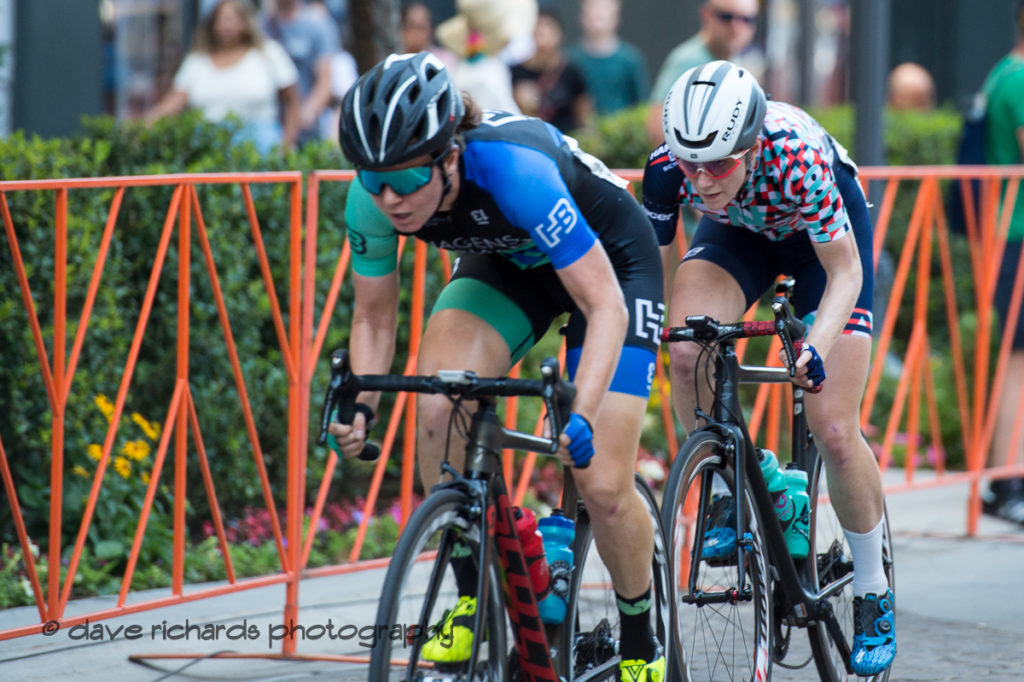
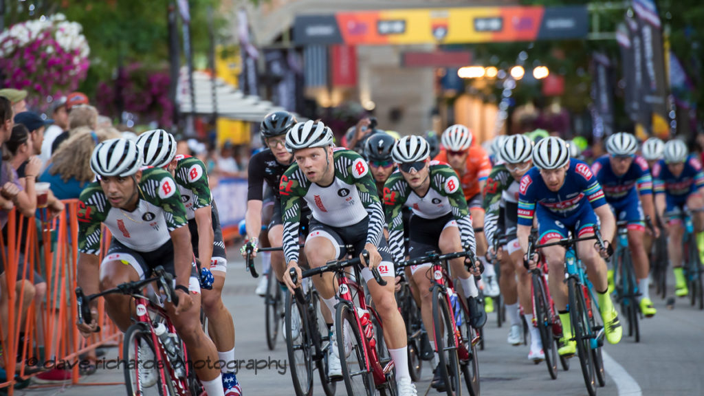
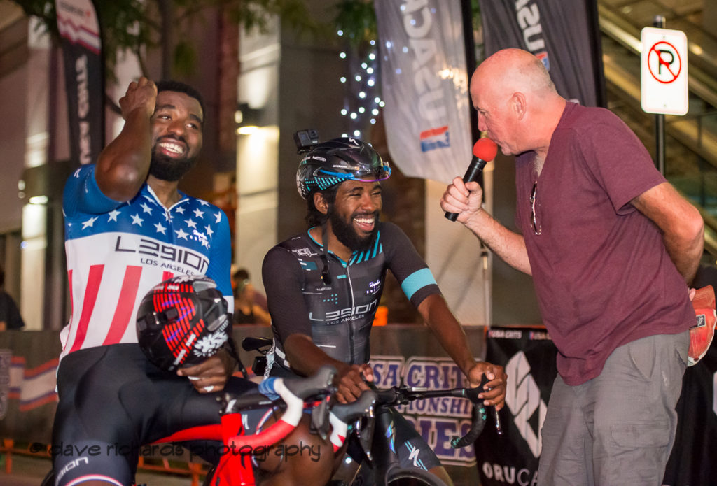
Two rider break during the Women’s D1/Pro race at the Salt Lake Criterium, USA CRITS series held at the Gateway Mall (Photo by Dave Richards, daverphoto.com)ButcherBox Cycling riders lead the pack past the fans during the Salt Lake Criterium, USA CRITS series held at the Gateway Mall (Photo by Dave Richards, daverphoto.com)Veteran announcer Dave Towle has a quick word with Cory Williams and brother Justin (Legion of Los Angeles) after taking 3rd & 1st respectively at the Salt Lake Criterium, USA CRITS series held at the Gateway Mall (Photo by Dave Richards, daverphoto.com)
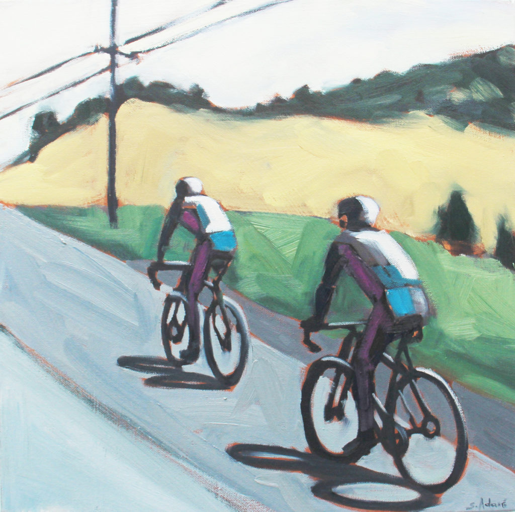
When my husband Tom and I are on scenic drives, I love taking photos out of the passenger side window. These quick shots have often become inspirations for some of my paintings. The fact that they lack detail can sometimes be an advantage when I later come to simplify a painting into essential elements. The reference for this painting, titled “Pedal On,” was taken on one of my favorite drives in Napa, California on the Silverado Trail. Silverado Trail is one of the most popular routes for road cycling in the Napa Valley.
Pedal On – Artist: Susan Adamé. Title: Pedal On. Medium: Oil on Canvas, Size: 16×16
Background
Susan Adamé’s varied art career has included 23 years working in clay, during which time she opened and operated an art gallery for nine years. She spent ten years as a textile designer in SF with an overlapping ten years as a collage artist, before moving into painting. Her work has been carried by the San Francisco Museum of Modern Art Artist Gallery and was placed in many well-known locations, including Green’s Restaurant in San Francisco and the Alameda County Courthouse. Her collage work was commissioned for numerous medical institutions across the country as it was seen as positive and uplifting.
Susan’s involvement in the artwork has extended to volunteering in the Albany, California community for over 30 years, which included drafting the city public art ordinance while she was on the Albany Arts Committee. During her time on that City body, Susan met Amy Smolens, another volunteer in the community. Susan was greatly impressed with the completeness of Amy’s presentation to that Committee and her commitment to the installation of artistic bike racks in Albany.
Amy had everything worked out ahead including the design, locations for the racks, and the funding, so it was immediately approved. The Arts Committee approved 6 Dero “Bike Bike Racks” in 2012, and the program has grown so we now have 66 in our town of 1 square mile. During this difficult time in which we all are Sheltering in Place, a friend inspired her to give away her artwork as a way to help bring enjoyment to others. As she put it, “No strings attached – I am trading cheer for goodwill.”
As soon as Susan thought of giving away her only bike painting, Amy came to mind as the most deserving.
Amy had this to say about Pedal On, “When I first moved to Albany in 1986, Susan owned Adamé Ceramics, a lovely shop featuring local art, including her own. I bought a lamp and some beautiful ceramic platters & bowls…but I didn’t know her well until last week. It’s so generous of her to gift her paintings during Shelter in Place and I was honored to be one of her recipients. “Pedal On” now brightens up my living room, where I’m spending more time than I ever have!”
For more of Susan Adamé’s art, see: susanadameart.com
By Don Scheese — In The Way to Rainy Mountain, N. Scott Momaday, a Native American writer of Kiowa ancestry, writes of returning to his ancestral homeland on the Great Plains. “A dark mist lay over the Black Hills, and the land was like iron. At the top of a ridge I caught sight of Devil’s Tower upthrust against the gray sky as if in the birth of time the core of the earth had broken through its crust and the motion of the world was begun. There are things in nature that engender an awful quiet in the heart of man; Devil’s Tower is one of them” (italics mine).
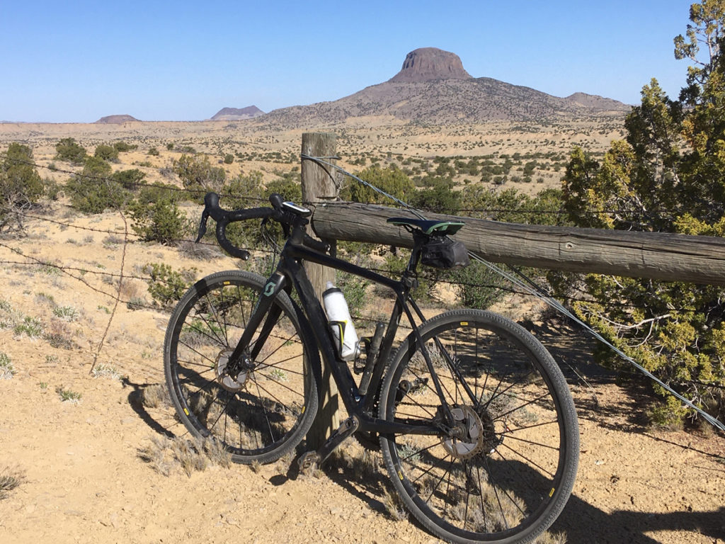
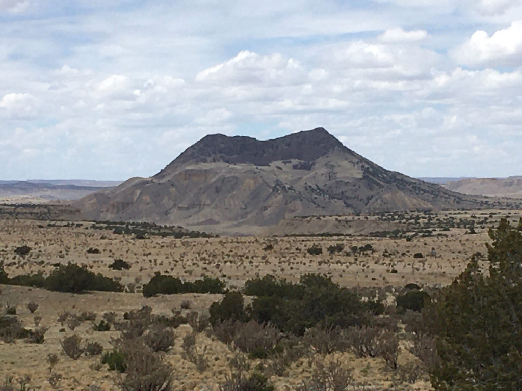
Cabezon at the start of the ride. Photo by Don Scheese
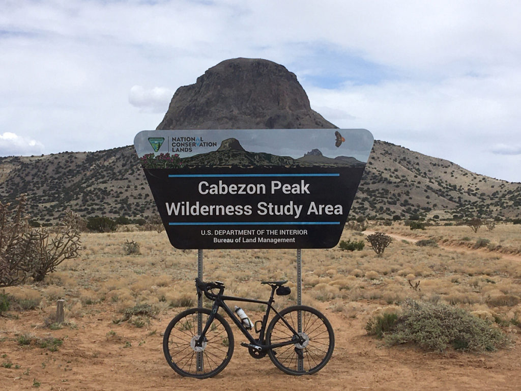
If you have ever driven highway U.S. 550 between Albuquerque and Durango, you could not help but have noticed off to the southwest a prominent volcanic peak rising from the high desert floor. That peak is Cabezon, Spanish for “Big Head,” and Cabezon is the Devil’s Tower of northwestern New Mexico. Towering almost 2000’ above the surrounding terrain, topping out at 7775’ above sea level, Cabezon is the tallest of fifty-some volcanic plugs protruding above the Rio Puerco valley, which in the 1800s was once a thriving Hispanic farming community. For thousands of years “Black Rock, “ as the Navajo refer to it, has functioned as a navigational landmark for travelers and residents.
I can see Cabezon from our house 40 miles distant, and have long been mesmerized by its hulking presence. So, one balmy spring day I headed out with the plan of paying homage to the peak by riding around it, figuring it would be around 30 miles of rolling desert gravel and dirt roads, through land owned by the BLM and private ranchers. Beautifully desolate country, where the Chihuahuan Desert meets the Colorado Plateau Province.
The drive to where I planned to start the ride took about an hour. I parked the car at the intersection of BLM roads 1113 and 1114, and headed off to the north/northwest in a counterclockwise direction, loaded with Camelbak, water bottles, spare tubes, and bars and fruit chews. A light northwesterly breeze kept the early morning temperatures nice and cool, and fair-weather cumulous clouds filled the sky.
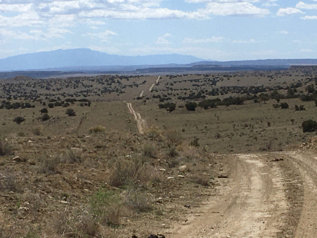
What struck me at the start of the ride, and throughout the circumnavigation of Cabezon Peak, was the absolute quiet—no sound of motor vehicles or people talking, the sheer absence of human-caused noise. Except for the sound of my tires rolling across the smooth hard-packed dirt and gravel road, the only other sounds I could hear were the occasional chittering of a rock wren and the soft whoosh of wind across the desert landscape. I found this predominance of natural sound intoxicating.
Pipeline Road with the Sandia Mountains on the horizon, on the Cabezon gravel ride. Photo by Don Scheese
The start of the ride lay along a rolling spine separating Cabezon, but a few air miles distant, from the desert floor sloping eastward toward the Nacimiento Range. On either side of the road brown sandstone slabs protruded like the spines of a stegosaurus, the harder rimrock still in the process of weathering away, and it was great fun to ride this roller-coaster along the crest of the ridge. Eventually I topped out on the mesa top towards the junction of Pipeline Road, so named for the underground gas conduit connecting the oil fields of the San Juan Basin to the Albuquerque metro area and points southeast all the way to Texas. It was then an easy coast down to the dry crossing of the Rio Puerco, then uphill a bit to the outskirts of the village of San Luis. To the north a long low mesa formed the immediate horizon, atop which ran the Continental Divide National Scenic Trail—a geographical divide delineating major watersheds of the West.
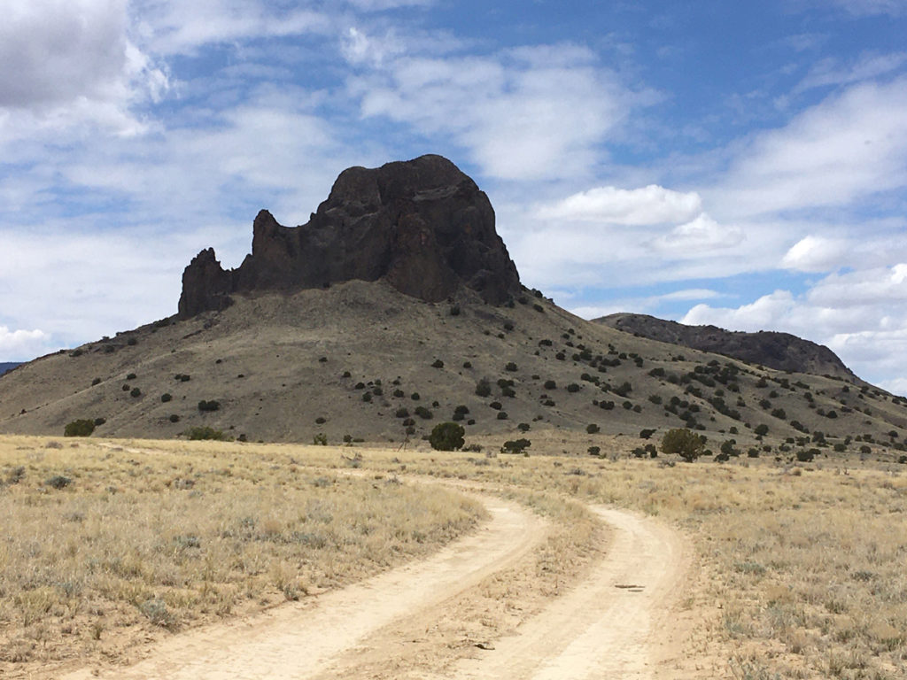
A sharp turn to the southwest, on a wider, more gravelly road, followed, and Cabezon rose all the more impressively from the lower desert floor. The peak was formed when molten lava oozed out to the earth’s surface through older sedimentary layers that had accumulated hundreds of millions of years ago when this area was covered by an ancient sea, followed by hundreds of millions of years of erosion, slowly exposing the basalt volcanic columns.
The Navajo tell a different story of the peak’s genesis. According to their legend the sacred peak of Mt. Taylor to the southwest is the body of a giant slain by their heroic figures, the Twin War Gods. The head of the giant’s body rolled off and became Cabezon Peak, and the lava flows of the area are the congealed blood of the slain giant.
Now I was on a section of the Great Divide Bike Route, the 3000-some mile track from Jasper, Canada, to Antelope Wells on the New Mexico-Mexico border. But only briefly, as I took the road less traveled by at the next junction, past the ghost town of Cabezon and across the Rio Puerco again, choked with tamarisk and dry as a bone, one of countless “seasonal rivers” in the arid Southwest. Then it was a long gradual trundle up to the top of the next divide, where I found myself sandwiched between volcanic necks: the brown-layered Cerro Cuate to the west, the Shiprock-like form of Cerro Chato to the south, and immediately due east, the Gibraltar of northwestern New Mexico, Cabezon Peak.
On the edge of Cabezon Wilderness Study Area. Photo by Don Scheese
A BLM sign indicated that I was on the western edge of the Cabezon Wilderness Study Area, an 8000-acre preserve of sorts encompassing the immediate area around the peak. A spur road headed off towards the peak and I followed it to the base of Cabezon where a trail register and a few fire rings dotted the ground. The peak looked impregnable, but a brochure in the register mentioned there was a route to the top, a 2.5 mile roundtrip hike and climb of almost 2000 feet. Another time, perhaps ….
Cerro Chato. Photo by Don Scheese
After refueling for a bit, I continued south, the road plunging down into the Abra de los Cerros (the Cove of the Hills), revealing fine views of a number of volcanic necks throughout the Rio Puerco valley, jutting like goosenecks above the desert floor. Past Cerro Chato—past Cerro de Santa Clara—past Cerro de Guadalupe…to the bottom of the drainage, where I took a hard left eastward at another road junction to begin the long steady climb up Canon del Camino. I passed more cow-burnt landscape dotted with juniper and pinyon pines, with some of the latter robustly thriving, while others stood desiccated and needle-less, weather-worn limbs glistening like the bones in an ossuary. The dead pines were apparently the victims of the Mega-Drought the Southwest is currently suffering from. Why do some survive and others not? The Darwinian struggle and the mystery of existence, survival, and death….
Cerro Cuate on the Cabezon gravel ride. Photo by Don Scheese
A lone vulture floated low over the terrain, making me think of Edward Abbey, who frequently expressed a wish to be reincarnated as a vulture. “Howdy Ed,” I said aloud, breaking the silence. In his most famous work, Desert Solitaire, Abbey tried to articulate the allure of the desert by writing, “The desert wears a veil of mystery. Motionless and silent it evokes in us an elusive hint of something unknown, unknowable, about to be revealed. There is something about the desert that the human sensibility cannot assimilate, or so far has not been assimilated.”
The pyramid-like hill of Cerro Cochino, and the long dark form of juniper-covered Mesa Prieta, loomed immediately to my right as I dropped into my lowest gears and huffed and puffed my way up the steep inclines. Back on top, arriving at the junction where I had begun the ride, 24 miles and 1400’ of ascent later, I could see to the distant south the high dark profile of the Sandias … my Home Mt Range. Turtle Mountain, according to the local Puebloan tribes. How satisfying are Long Views, Distant Horizons, I thought. For 25 years I lived in exile in the Midwest, where a ‘long view’ was but a few miles off….to hell with a ‘prairie perspective,’ I decided—much better, much more inspirational, are the far-off vistas of the American West.
It is a Cyclist’s Truism that the earlier you ride in the day, the lighter the wind, the fewer the vehicles, and the more enjoyable the experience will be. During the entire 24-mile loop I met with only one vehicle, an Hispanic rancher in a battered Nissan pickup who motioned to me in passing if I needed any agua. No gracias, I said.
I had been gone only a few hours, but somehow the ride through the backcountry of Cabezon had seemed much longer, deliciously longer—as if I had experienced a different sense of time while cycling through the solitary silence. Desert Time.
And above it all loomed the dark hulking shape of Cabezon, engendering an awful quiet in the hearts of all who pass by.
Don “Seldom Seen” Scheese lives and rides in New Mexico, always in search of new adventurous routes, especially on gravel roads.
TASU (formerly DMBTA) with the help of Fezzari Bicycles in partnership with Greater Zion has been working with The Pine Valley Ranger District to create two amazing new trail networks. The environmental assessment is out for public comment and we need your support.
Photo courtesy Trail Alliance of Southern Utah
Below is a brief summery of the project, feel free to use any of this in your comments.
60 miles of purpose built mountain bike trails at higher elevations and cooler temperatures up to 7,000 feet elevation
New XC race course designed to meet NICA requirements with parking for large crowds
Designed with multiple access points to allow use of the network even during an event
23 miles of directional downhill trails built for a variety of skill levels
Designed with riding loops as well as shuttle options
There will be a 10+ mile true enduro downhill with “a”and “b” lines, and a 1.8 mile jump line
Submitting Comments
SUBMIT COMMENTS BY SEPTEMBER 18, 2020. The best method for submitting comments is through the public participation portal on the project webpage:
To submit comments using the web form on the project webpage select “Comment on Project” under “Get Connected” on the right side of the project’s webpage, and scroll down to the submission form.
Written comments may also be submitted by mail or hand delivered to Nicholas Glidden, Pine Valley District Ranger, 196 E. Tabernacle Street, Suite 38, St. George, UT 84770.
Spring Hollow MTB Trail NetworkGrass Valley MTB Trail Network
Seeks Necessary Title Sponsorship to Fund Plan 2021 Return
Boise GreenBike will hit the pause button on the bike share program at the end of September but plans to revive and improve the service in the spring of 2021.
About a year ago, Valley Regional Transit’s bike share program started making plans to transition to a new vendor and bring in electric-assist bikes to replace the aging pedal-only bikes. The program had faced many challenges with out-dated technology, and a vendor who would no longer support third-party operators like Boise GreenBike.
Photo courtesy Boise GreenBike.
Through the Request for Proposal process, Drop Mobility, a Canadian-based bike share provider, was selected last fall to supply the next generation of bike share to Boise. Feeling the program had always been too small, VRT chose to try and grow the system from the 127 bikes in operation today, to 300 or more over the next few years. Naturally, expanding the number of bikes was going to cost more to operate.
Boise GreenBike has always been an enterprise program of Valley Regional Transit. As such, it has relied on ride and membership revenue and sponsorship to cover the cost of operations. Sponsorships, and most importantly, the title sponsorships, account for 75% of the operating budget. VRT approached the existing title sponsors with the expansion proposal and was turned down, leaving Boise GreenBike with a massive hole in its budget. The City of Boise stepped in with a one-time grant to keep the program operational through the end of the fiscal year, September 30.
Photo courtesy Boise GreenBike.
VRT had been actively pursuing new title sponsors when the coronavirus pandemic hit, creating significant headwinds as businesses lost the capacity for or interest in becoming sponsors. VRT is still working to recruit one or more title sponsors so it can continue with plans to launch the new, more extensive and all-electric system in the spring of 2021. For now, however, the city will be without a bike share for a few months. Failing to find new title sponsors will mean the end of bike share in Boise.
What happens with existing memberships?
Boise GreenBike will be reaching out to all members, especially those with credit in their accounts. Those riders will have the option of riding off their credits or accepting credit in the new system when it launches. Boise GreenBike will not be providing cash refunds.
More than ninety percent of Boise GreenBike riders are “Pay as You Go” members. For them, it is a simple matter of riding their balance down to zero. If they ride more than their balance, the additional time will be charged at the usual prorated $5 per hour.
For long-term members, those with Monthly, Student, Annual, and Premium memberships, the new bike share system will honor the remaining value they have in their accounts. Members will also be offered generous terms in the new system to get them to return as sustaining customers. In the meantime, the auto-renew on these long-term accounts has been turned off, so members won’t be charged for benefits they won’t be able to use. Also, effective immediately, the system will not allow any new long-term memberships. New riders will have only the “Pay as You Go” membership option.
What happens to the existing bikes?
The bikes are still perfectly serviceable, but the controllers will be shut off and removed since the hardware will become useless on October 1. VRT is developing plans for a second life for these bikes. They may be repurposed for community bike libraries, similar to a program established last year with Interfaith Sanctuary. The bikes might also be auctioned off.
What happens with the racks and station hubs?
The bike racks and station hubs will stay in place, as the next iteration of bike share will be able to use them. The only other change is that all of the payment kiosks will be removed. The kiosks were turned off with the start of the pandemic to eliminate the risks associated with people using touchscreens.
Members should direct questions about their membership status to the Help Desk at 208-345-7433, or email [email protected].
LOGAN, Utah (August 19, 2020) — The Allen and Alice Stokes Nature Center announced its first ever virtual race, Wild Miles, to encourage people to get outside and get active during the uncertainty of 2020.
Wild Miles will begin on September 16, the birthday of founder Allen Stokes and run to October 25, the birthday of founder Alice Stokes. Participants will be challenged to go 105 miles (Alice’s age this year) in those 39 days. They can bike, hike, run, swim, walk, or any other way of moving to accomplish those miles, but just get outside and enjoy nature while supporting Stokes Nature Center and its mission to make nature education and outdoor exploration possible for all people.
“We at Stokes have been working to create opportunities to keep people outside and engaging with nature, especially over the past few months. We know that nature supports mental and physical health for all people and this was just one more way for us to encourage healthy activity for all people. We feel this distance is challenging, but achievable and with support from our staff, everyone that signs up can reach their goal. Especially these days, with so many organized events being cancelled, this is a great way to not let your training go to waste, but rather still achieve something significant and help make a difference for our community,” says the Executive Director, Kendra Penry.
Photo courtesy Stokes Nature Center
This event will offer two ways for people to participate: you can register for $60, which includes a custom medal when you finish 105 miles and a virtual swag bag. Or you can earn a free entry by fundraising to support Stokes Nature Center. Fundraisers are asked to fundraise at least $105, but will also earn a unique Wild Miles t-shirt for their efforts, in addition to earning additional swag along the way to fundraising milestones.
“Stokes Nature Center has always been committed to making nature education and outdoor exploration possible for all people, and this means we keep our programs either free or low-cost. Like many non-profits and small businesses, the pandemic has severely limited our revenues, but this is a chance for people to not only do something fun, but also help us continue to serve our entire community. We believe that all people can learn to appreciate and be better stewards of the natural world with the right knowledge and tools, and this event will help us carry on with that work so that we as well as future generations can all enjoy our great outdoors in Utah,” continued Penry.
Photo courtesy Stokes Nature Center
For those unsure of their ability to reach 105 miles, SNC is offering two supported, drop-in events. There will not be an official start or finish line, but there will be aid stations available. These include a bike ride around Bear Lake on October 3 with three fully stocked aid stations sponsored by Gnarly and Honey Stinger and a mobile bike repair service sponsored by Joy Ride Bicycles, the official sponsor of this event. In addition, there will be a supported hike/run/mountain bike ride on October 17 on the River Trail in Logan, UT, with an aid station right in front of the nature center that participants are supporting. Those wanting to participate in the supported events but not do the full race will be able to by paying a drop-in fee of $10 for each activity.
Registration is available at http://logannature.org/wildmiles where you will also find the mileage log for self-reporting your distance.
Anna van der Breggen is a Dutch professional road bicycle racer, who currently rides for Team Boels–Dolmans. She is the reigning Olympic champion, having won the women’s road race at the 2016 Olympic games in Rio de Janeiro. She also won the World Championships in 2018, and is a two-time winner of the Giro Femminile (2015, 2017).
Anna van der Breggen (NED) Specialized Tarmac – Team bikes supported by SRAM in 2020 – July 30, 2020. Photo by Sean Robinson/velofocus.comAnna van der Breggen (NED) Specialized Tarmac – Team bikes supported by SRAM in 2020 – July 30, 2020. Photo by Sean Robinson/velofocus.comAnna van der Breggen (NED) Specialized Tarmac – Team bikes supported by SRAM in 2020 – July 30, 2020. Photo by Sean Robinson/velofocus.comAnna van der Breggen (NED) Specialized Tarmac – Team bikes supported by SRAM in 2020 – July 30, 2020. Photo by Sean Robinson/velofocus.comAnna van der Breggen (NED) Specialized Tarmac – Team bikes supported by SRAM in 2020 – July 30, 2020. Photo by Sean Robinson/velofocus.comAnna van der Breggen (NED) Specialized Tarmac – Team bikes supported by SRAM in 2020 – July 30, 2020. Photo by Sean Robinson/velofocus.comAnna van der Breggen (NED) Specialized Tarmac – Team bikes supported by SRAM in 2020 – July 30, 2020. Photo by Sean Robinson/velofocus.comAnna van der Breggen (NED) Specialized Tarmac – Team bikes supported by SRAM in 2020 – July 30, 2020. Photo by Sean Robinson/velofocus.comAnna van der Breggen (NED) Specialized Tarmac – Team bikes supported by SRAM in 2020 – July 30, 2020. Photo by Sean Robinson/velofocus.comAnna van der Breggen (NED) Specialized Tarmac – Team bikes supported by SRAM in 2020 – July 30, 2020. Photo by Sean Robinson/velofocus.comAnna van der Breggen (NED) Specialized Tarmac – Team bikes supported by SRAM in 2020 – July 30, 2020. Photo by Sean Robinson/velofocus.comAnna van der Breggen (NED) Specialized Tarmac – Team bikes supported by SRAM in 2020 – July 30, 2020. Photo by Sean Robinson/velofocus.comAnna van der Breggen (NED) Specialized Tarmac – Team bikes supported by SRAM in 2020 – July 30, 2020. Photo by Sean Robinson/velofocus.comAnna van der Breggen (NED) Specialized Tarmac – Team bikes supported by SRAM in 2020 – July 30, 2020. Photo by Sean Robinson/velofocus.comAnna van der Breggen (NED) Specialized Tarmac – Team bikes supported by SRAM in 2020 – July 30, 2020. Photo by Sean Robinson/velofocus.comAnna van der Breggen (NED) Specialized Tarmac – Team bikes supported by SRAM in 2020 – July 30, 2020. Photo by Sean Robinson/velofocus.com