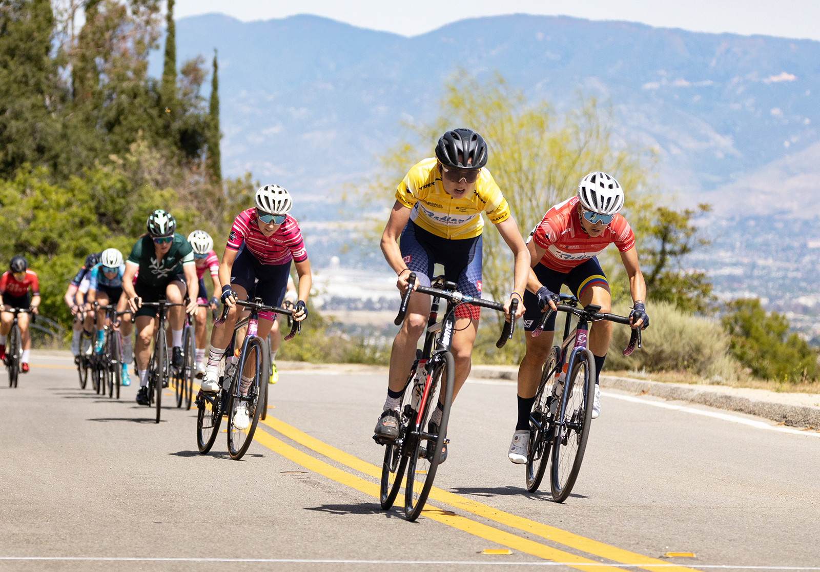
SALT LAKE CITY, Utah (July 1, 2022) The DNA Pro Cycling team has announced the signing of Emily Marcolini to its 2022 roster. The 26-year-old Canadian cyclist will race with the team through the remainder of the year and is expected to be on the roster for DNA’s upcoming international stage races, Vuelta a Colombia Femenina and Tour Cycliste Féminin International de L’Ardèche.
Emily Marcolini (in yellow) during the Sunset Loop stage at the 2022 edition of Redlands. Photo by Snowy Mountain Photography
A strong climber and breakaway rider, Marcolini demonstrated her talents this year with mountain stage wins on Oak Glen at the Redlands Yucaipa Stage as well as the famed Gila Monster stage at the Tour of the Gila. She is signing from the US domestic team, 3T/Q+M and previously rode with Team TIBCO/SVB.
“I am thankful to the 3T/Q+M team for giving me the opportunity to succeed this season,” said Marcolini, “and I am thrilled to jump back to the UCI level with the DNA Pro Cycling team, which is such a well-run organization with awesome riders.”
Marcolini, who hails from Sudbury, Ontario, joins two other Canadians on the DNA squad, Maggie Coles-Lyster and Kaitlyn Rauwerda.
“We are excited to have Marcolini join the team mid-season. Her unique strengths and experience will strengthen our team dynamic and increase our opportunities for success,” said Catherine Fegan-Kim, team co-owner and director.
By David Collins — Candidates for the most legendary mountain man of the 19th century surely include Jedidiah Smith, John C. Fremont, and Kit Carson. But scholars of the American West often top the list with Jim Bridger and although he died nearly 150 years ago, his ghost still roams the mountains, valleys, and endless canyons of Wyoming.
These three century rides crisscross some of Jim’s favorite stomping grounds. So don’t be surprised if you find yourself thirsty, a little calorie deprived and looking twice over your shoulder because the first time you looked, you could have sworn you saw the old mountain man galloping by your side with a bunch of prime beaver pelts lashed to his saddlebags.
Excursions and explorations are part of the fun of unsupported bicycle touring at your own pace. Mileage estimates are approximate and may vary depending on your tracking system and whims of the ride. Be sure to tell someone your plans and allow them to track your location using a smartphone or other device.
Solo or unsupported distance cycling often presents potentially dangerous situations related to terrain, weather, equipment, traffic, navigation, and mental awareness. Even experienced cyclists must plan carefully and use wise judgment to successfully mitigate inherent risks of the sport or end a ride before it turns injurious or deadly. If you are new to the sport or have never ridden a bicycle more than 100 miles in a single day, learn the ropes with a seasoned buddy or local cycling club before strapping on these rides.
Make sure to check maps, plan your route and check local road conditions before you go. As with any ride, be aware of your surroundings and of roadway traffic.
Ready to ride? Not quite yet. First, learn more about Bridger by reading one of his biographies; I recommend J. Cecil Alter’s Jim Bridger or Jerry Enzler’s Jim Bridger: Trailblazer of the American West.
Now, it’s finally time to fill water bottles, stuff gear bags, click in and start pedaling through some of Jim Bridger’s Wyoming.
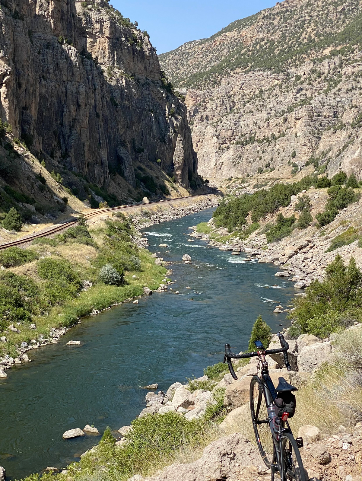
Riverton to Basin
Route:
North on Hwy 26 to Shoshoni, east on Hwy 20 through Thermopolis, then north on Hwy 433 in Worland. At the dead-end of Hwy 433, turn west on Hwy 789 to Basin. 115 Miles.
Terrain:
All paved. Bighorn River pathway, Wind River Canyon, steady rolling climbs and dips and extended flats.
Riverton to Basin ride. Photo by David Collins
What to See:
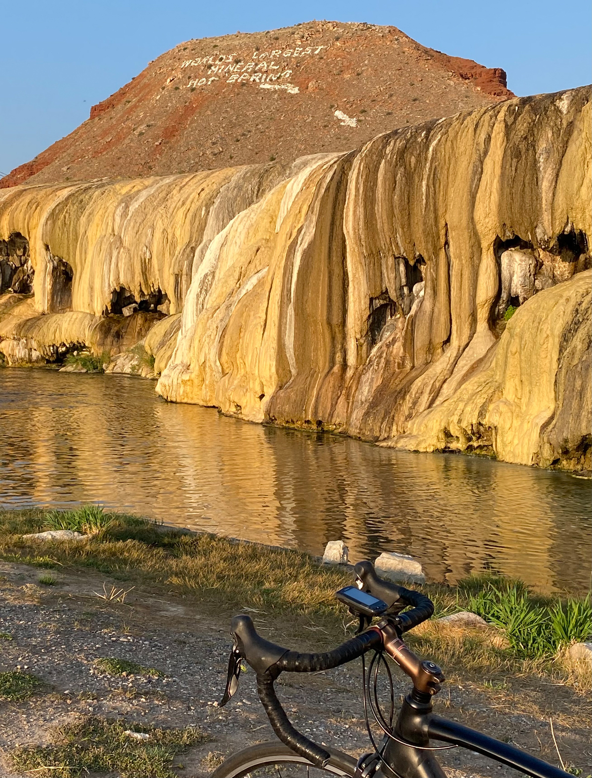
Historic Riverton, site of 1830s trapper rendezvous. Ghosts of Jim Bridger, Kit Carson and Moses “Black” Harris still ride the town breezeways (every summer Riverton hosts a re-enactment the annual gathering); Wind River Indian Reservation lands; Boysen Reservoir; Wind River Scenic Byway with the striking red and yellow rock of the Owl Creek Mountains, often speckled with mountain sheep; layers of rock marked with interpretive geological era signage; the world’s largest mineral hot spring (according to Thermopolis signs); Wyoming Dinosaur Center; remote rural farms and ranches, small townships and historic markers related to other Jim Bridger rendezvous points.
From Riverton to Basin ride. Photo by David Collins
Selfies and Photo Ops:
Scenic Wind River Canyon is loaded with dramatic backdrops of cliffs, riversides and winding road shots; signs of geological interest throughout the Wind River Canyon; Thermopolis sites including: Smoking Waters buffalo sign, hot springs banks and river sites, Teepee Fountains, distinctive hill/plateau thumb sticking out of the valley (turn around to see it as you exit Thermopolis and climb the first ridgeline). Trail of the Whispering Giants Indian Brave statue near the turn in Worland; Welcome to Basin rock and timber sign; Big Horn County courthouse.
Wildlife:
Big horn sheep, elk, deer, mountain lions, bobcats, black bears, golden eagles, osprey and other raptures, lizards, snakes, foxes, coyotes, porcupines, and possums.
Best Post-Ride Eats:
Copper Corner Cafe. Good home cooking served on a flashy copper bar. A bowl of Copper Chili is hard to beat on a cold day, but if it’s warm outside and you are sundrenched from the day’s ride, tuck into a Rebel Burger and some Cloud Peak Nachos chased by a butterscotch or huckleberry milkshake and finished off with a homemade slice of pie. When there are few eateries to choose from in town, it can turn out to be a bad day. That’s not the case in Basin thanks to The Copper Corner Cafe.
Still Have Legs, Lungs, and Sunlight?
Pull your sandals out of your saddlebag and hike Quarry Trail in Thermopolis. The one-mile loop begins and ends at Smoky Row Cemetery*, located in the Buffalo Pasture. It’s a short but challenging hike (beware of buffalo).
*According to the town’s visitor guide, Smoky Row Cemetery dates “back to the 1890s. Seated in a gulch east of Star Plunge, Smoky Row was living quarters for the hot springs’ earliest western visitors. Among those buried there are: Mollie Koshear, who slipped over the falls into
the river; Augernose Jane; Jack Berry, an old soldier who dove into the first swimming pool and was killed; and a nameless woman, described as very large.”
Two Park Centuries Back-to-Back
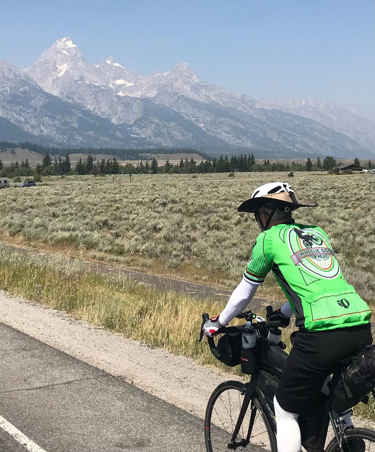
Yellowstone National Park officially turns 150 years old this year. Decades before that, the region hosted Jim Bridger and other mountain men who spread stories of its abundant wildlife, amazing mud pots, geysers, falls and other wonders. In 1929, Grand Teton National Park was created to protect the Teton Range and the lakes on the east side of the mountains. Bridger first visited Jackson Hole and the broader region of the Tetons more than 100 years earlier. These two rides flow through the area with grace and a little vigor at times, treating cyclists to some of the same sights and smells of JB’s yesteryear.
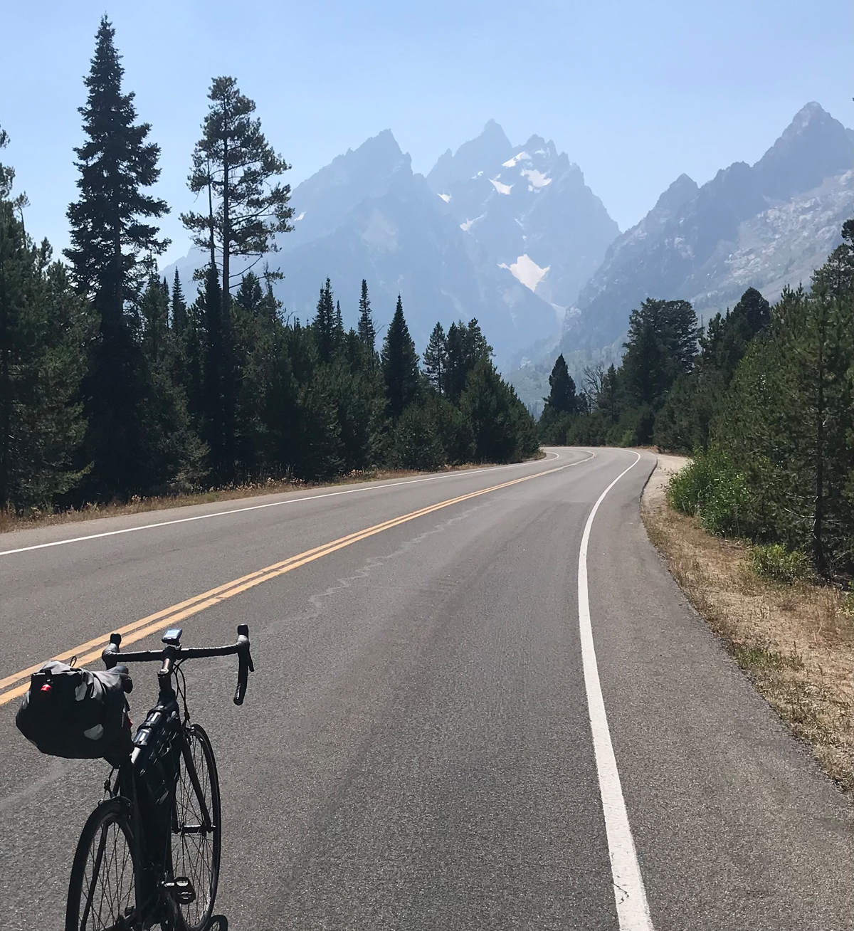
1. Alpine Junction to Flagg Ranch Resort
Route:
Ride east out of Alpine Junction, on Hwy 26 to Jackson Hole, stay on Hwy 26 headed north out of Jackson, then turn north on Hwy 89 at Moran to Flagg Ranch Resort. 97 Miles.
Terrain:
All paved. Skirts the Snake River up the canyon on winding roads through Jackson Hole traffic over many climbs (total day’s elevation gain of 3,913 ft.) and through flats and forests.
From the Alpine Junction to Flagg Ranch Resort ride. Photo by David Collins
What to See:
Snake River with seasonal anglers, rafters, kayakers and wildlife cavorting in its chilly waters; banks of evergreen trees on sunlit slopes; stark cliff sides (cutaways to make room for the road); Jackson Square; National Elk Refuge just north of Jackson Hole; National Museum of Wildlife Art (even if you don’t stop to go inside, briefly detour up the short access road to the building – it’s worth the view of the elk refuge across the street below); stunning views of the Grand Tetons from more angles than you can imagine including distant majestic panoramas and close-ups from the shoreline of Jackson Lake.
Cyclist on Alpine Junction to Flagg Ranch Resort ride. Photo by David Collins
Selfies and Photo Ops:
As you slip up the canyon from Alpine Junction, turn around and see the Snake River flowing down the canyon; dozens of other river backdrops from high above or down in the river bottoms next to the banks; Welcome to Jackson signs; the famous four corners of Jackson square adorned with huge walk-through arches made out of elk horns; Million Dollar Cowboy Bar on the square; National Museum of Wildlife Art statues and signs; giant lodge pole sign marking the entrance to Grand Teton National Park; Be Bear Aware signs and of course the Grand Tetons. There are so many Teton related photo ops it’s a little ridiculous but don’t get so spoiled with them along the way that you forget to snap a few.
Wildlife:
Grizzly bears, black bear, moose, elk, deer, mountain lions, otters, beaver, mink, bobcats, golden eagles, osprey and other raptures, trophy fish, lizards, snakes, wolves, foxes, coyotes, porcupines, and possums.
Best Post-Ride Eats:
Sheffield’s Restaurant at Headwaters Lodge. It’s a great breakfast joint to get you on your way for tomorrow morning’s ride to Old Faithful. More about that ride later, but for now, let Elk medallions with huckleberry sauce or grilled salmon with miso ginger glaze and mango pico de gallo decorate your supper table. Foodie’s food served in a casual lodge atmosphere without the snootiness you may expect when you see items like that on the menu. Needless to say, they serve quality proteins in suitable quantities for your recovery efforts from the long day in the saddle. Earlier in the day, you’ll also get to choose from dozens of tasty nosh options in Jackson Hole to help fuel the rest of the ride.
Still Have Legs, Lungs, and Sunlight?
Pedal over to Teton Village just 13 miles east of Jackson; the views along the way are worth the detour and the resort area features a few easy stops for snacks, goodies, and keepsakes. Make a note to ride the tram up the mountain when you have some extra time (where you can eat tasty homemade waffles at the little alpine hut on the mountain top).
Notes:
There are multiple bike paths over several miles of the ride. They may be helpful but sometimes the grade makes them less desirable than staying on the highway.
Use extra care for a few miles just north of Hoback Junction due to narrow road conditions with little or no shoulders.
2. Flagg Ranch Resort to Old Faithful Inn (around the big loop)
Route:
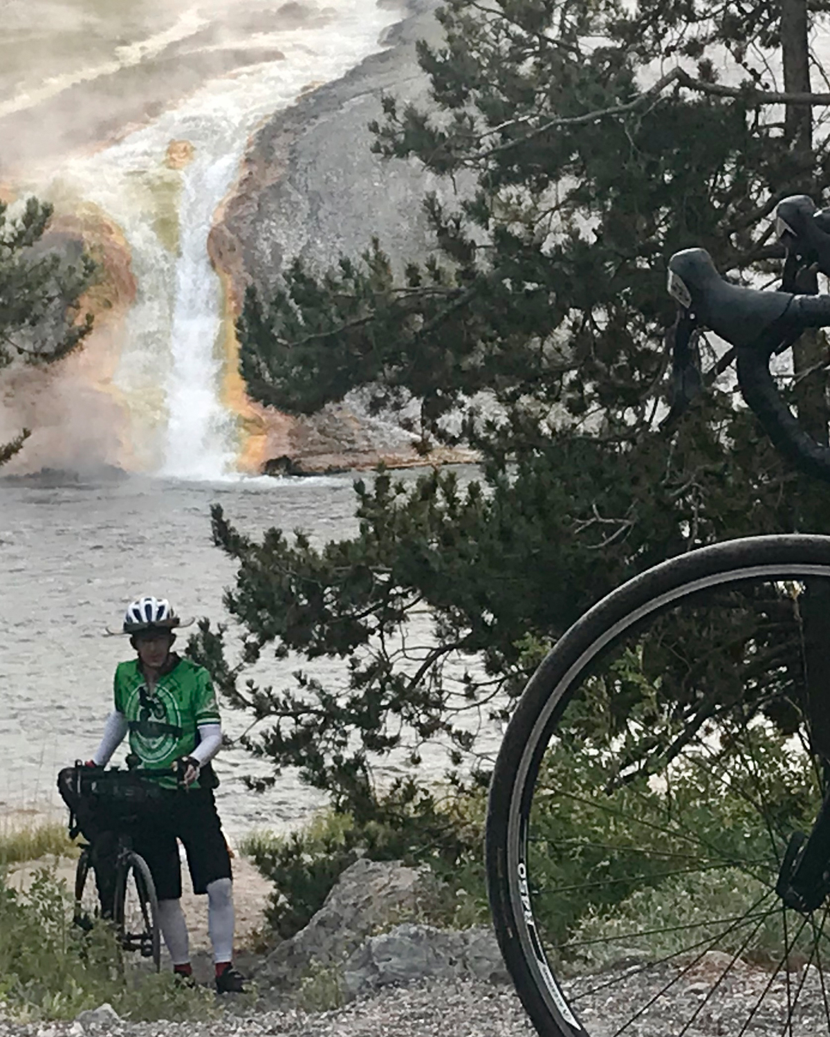
Ride north on Hwy 89 to West Thumb, turn east on Grand Loop Road and ride up and around the fat part of the loop until you reach Old Faithful Inn (with a required short detour to see the Grand Canyon of the Yellowstone). 109 miles. 4,991 ft total elevation gain.
Terrain:
All paved. Several noteworthy climbs and crossings of the Continental Divide, lakeshore flats and broad meadow crossings.
Cyclist on Flagg Ranch Resort to Old Faithful Inn ride. Photo by David Collins
What to See:
West Thumb Geyser Basin; Otter Creek; Potts Hot Spring Basin; Yellowstone Lake shoreline; Bridge Bay; Lake Village; Lake Junction; Fishing Bridge; Hayden Valley; Lower Falls of the Yellowstone River; Artist Point; Grand Canyon of the Yellowstone; Canyon Village; Virginia Meadows; Norris Museum; Gibbon River Rapids; Chocolate Pots; Gibbon Geyser Basin; Beryl Spring; Iron Spring; Madison Junction; Cascades of the Firehole; Firehole Canyon; Fountain Paint Pot; Excelsior; Grand Prismatic Spring; Upper Geyser Basin; Old Faithful Geyser; Morning Glory – found at the end of a short walk on the boardwalks at Old Faithful.
Selfies and Photo Ops:
Welcome to Yellowstone signs; Continental Divide signs throughout the ride and every point mentioned in the What to See section above feature great photo backgrounds; in addition, pay close attention, because traveling at bicycle speed, you will find little gem photo ops missed by fellow park visitors traveling in cars and RVs. Perhaps you’ll see otters in the creek (maybe even in Otter Creek), wildlife peeking out from the edge of the forest line of trees or fish swimming right up to the shoreline in the clear waters. And if you stop for a minute at Hayden Valley and pull out the monocular from your gear bag, you might spot a wolf or a bear or two across the valley. In any event, the valley offers unbeatable photo backdrops. There are so many other photo ops in the park, you might have to ration yourself so you can enjoy the ride in real time too.
Wildlife:
Grizzly bears, black bear, moose, elk, deer, mountain lions, otters, beaver, mink, bobcats, golden eagles, osprey and other raptors, trophy fish, lizards, snakes, wolves, foxes, coyotes, porcupines, and possums.
Best Post-Ride Eats:
The Old Faithful Inn Dining Room. Yes, the food is good but look up! The inside timber is impressive and the whole place gives off unforgettable vibes. Back to the restaurant; be sure to get reservations (they are only available to overnight in-park lodging and campground guests and can be made up to 60 days prior to arrival). The menu changes often and you usually have to visit the restaurant to see it. Their claim to provide good eats for “most any taste and budget” is true. They put out quality meats, sweet desserts, and other broad selections of delicious food. It’s a casual meal in an unforgettable lodge with the world’s most iconic geyser right outside.
Still Have Legs, lungs, and Sunlight?
Turn north at Norris Junction and ride about six miles to Roaring Mountain. It’s a large thermal area that has many fumaroles on the western slope that hiss and pop. It can be seen and sometimes heard from the road.
Notes:
Be bear aware throughout the ride.
Check road status before you go since some sections of the ride are closed in shoulder seasons and winter.
Bridger Bonus
Hungry for more saddle miles in Jim Bridger country? Checkout the Bridger Valley Historic Byway in SW Wyoming. It’s a 20-mile loop that includes Fort Bridger, Urie, Mountain View and Lyman. Plan to spend extra time at Fort Bridger. They have museums, markers and buildings that tell important stories about Bridger’s life and influence related to historic trails that converge nearby including the California/Oregon Trail, the Mormon Trail, the Pony Express Route, the Transcontinental Railroad, and the Lincoln Highway.
By Breanne Nalder, MS, RDN — It’s the topic that never gets old when talking about nutrition for cyclists, as a major goal for most of us is to optimize our power to weight ratio. We all want to be lean machines and go uphill like billygoats, right?! In 2016, I wrote an article titled “Weight Loss vs. Power Gain, The Struggle is Real” which tackled the subject by discussing methods to determining your ideal power:weight (P:W) taking into consideration male and female body types as well as personal goals. The next step is having realistic expectations of yourself and establishing healthy methods to reaching your goals.
For a quick recap of the math from the preceding article, P:W is determined by the simple formula power (watts) ÷ mass (kg). Feel free to contact me personally for help determining the realistic numbers for you, as the ideal range should be specific to your body type, fitness level and type of cyclist you are. There was a reference chart in the last article that gave P:W ranges for men and women at various fitness levels. I’d be happy to provide this information again to anyone who wants it. (See also: Determining Your Ideal Body Weight for Cycling: Weight Loss vs. Power Gain)
Power Profile Chart. Use this chart to determine typical power outputs (watts/kg) for different categories of cyclists. Republished with permission of VeloPress from Training and Racing with a Power Meter, 2nd Ed. by Hunter Allen and Andrew Coggan, PhD. Learn more at velopress.com/power.
So now let’s talk about methods to decreasing body fat while maintaining or increasing lean muscle mass and strength. We want to do this without limiting our ability to train. What I mean by that is if we decrease caloric intake too much, we won’t have the energy to ride. You may lose weight at first, but it is unsustainable and can mess up your metabolism over time. Taking all of this into consideration, it can be helpful to think of your body as an engine that will perform best if you put the proper fuel in the tank.
The first thing you want to do is determine your body’s metabolic needs. This can be done by measuring your Basal Metabolic Rate (BMR) to learn how many calories you need to survive. From there we can figure out the ratios of carbohydrates, fats, and proteins that are appropriate for you on a daily basis. Then the real fun starts: finding the exact amount of fuel you need for training and racing. It is crucial that you get the proper amount of carbs going into an effort, keep up on energy and hydration during workouts, and recovering properly with adequate carb replacement, electrolytes, and sufficient protein so that your body can be ready to do that all again tomorrow! (I can help you determine those exact numbers so use my contact info below for personal reccs and meal planning, etc. And yes, I do have a BMR machine that you can come get measured on.)
For those of you who want less detail and more simple answers, here is a list of ideas and methods you can use to safely “diet” while maintaining your training load:
Think of your body having 2 different engines, one that needs regular fuel and one that needs sport food. All of your regular daily meals should be balanced with lean proteins, healthy fats, and moderate carbohydrates, with a big emphasis on lots of raw fruits and veggies. These are the times to limit sugar, chips, candy, treats, etc. That is your “diet.” The extra calories you need on top of your BMR are energy for exercise, so that is when it is ok to drink your calories and have gels or bars as your workout requires.
Divide your meals and snacks up into smaller portions. You will find you are less hungry and more satisfied if you eat small meals more frequently.
Don’t starve yourself! You will end up binging later on anyway so you’re better off to eat smaller meals more often. Keep your engine going rather that letting it run out of gas then need a huge meal. Your metabolism will thank you too.
Eat your carbs early in the day and around exercise. Remind yourself that you need energy to get through your day, not to sleep!
Have most of your salad greens, lean proteins, and other veggies at night. They will make you feel full because they take longer to digest. You can break down all that fiber while you sleep.
If you’re a late night snacker, find light treats that satisfy a craving, have a bite or two, and then put it away! Or even better, make yourself a cup of relaxing tea (maybe with some honey for sweetness) and let yourself relax and get to sleep without empty calories right before bed.
Give your body 12 hours of a fast every day. Instead of worrying about what time you have to stop eating, base the time that you finish food for the day to be 12 hours before when you’ll be eating breakfast. For example, if you’re an early bird that rides at 7am, it’s best to have dinner at 6pm then breakfast at 6am the next day pre-ride. If you ride after work, you likely eat dinner later. So maybe you are done eating at 9pm so you have breakfast around 9am the next day. The more regimented you are with timing of food, the easier it is to feel satiated and develop patterns that become habits.
Use a tracking app or food journal to hold yourself accountable. Being honest with yourself is a big part of being successful. So be proud of what you put in to your body, as it will change and adapt to the healthy choices you make.
Time for the customary self-promotion! My job is to do all this math for you, then provide an individualized meal plan to help you reach your goals. I’d love to help you reach your optimal power:weight and feel great on your bike, all while enjoying your food and lifestyle.
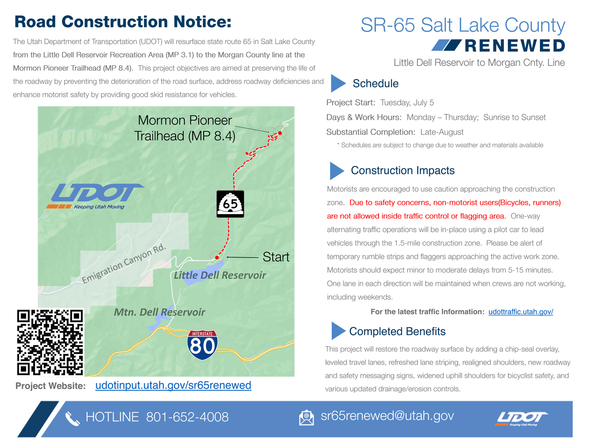
SALT LAKE CITY, Utah (June 29, 2022) — UDOT today announced that the East Canyon Road, SR-65, from the Little Dell Gate in Salt Lake County to the Big Mountain summit/Morgan County line will close from July 5, 2022 to the end of August.
UDOT will be chip sealing the road and performing other roadway improvements. These will include shoulder widening in the eastern (uphill for bikes) direction, additional signage for bikes, and pavement markings. The widened shoulders will make uphill cycling safer once complete.
UDOT asks that cyclists not use the roadway until repairs are complete. It is possible that the repairs will be completed prior to the end of August.
Bike Along Historic Route 66 in Oklahoma, Minnesota’s 10,000 Lakes, or the Delaware River
MISSOULA, Montana (June 28, 2022) — Adventure Cycling Association is proud to announce the designation of three new U.S. Bicycle Routes in Oklahoma, Minnesota, and Delaware, and the realignment and extension of additional routes through Indiana and Michigan, adding more than 650 miles to the U.S. Bicycle Route System and improving connectivity and the cycling experience.
National Bike Corridor Map, courtesy Adventure Cycling Association. [PDF Version]The new routes in Oklahoma and Delaware are the first U.S. Bicycle Routes in those states, while the new route in Minnesota is its fourth. USBR 66 in Oklahoma boasts the most rideable miles of Historic Route 66, the “Mother Road,” USBR 20 in Minnesota offers miles of off-road riding and several of the state’s 10,000 lakes, and USBR 201 through Delaware takes in historic sites and Delaware River views.
The realignment and extension of routes through Michigan and Indiana were made based on feedback from cyclists and local communities, as well as the completion of infrastructure improvements and other projects.
“It’s been 96 years since the iconic Route 66 opened to motor vehicle traffic in the U.S.,” said Jim Tymon, Executive Director of the American Association of State Highway and Transportation Officials. “Now, cyclists can follow the historic route for more than 400 miles through Oklahoma using the newly designated USBR 66. This latest round of U.S. Bicycle Route System designations exemplifies AASHTO’s steadfast commitment to creating active transportation facilities in rural and urban America.”
The U.S. Bicycle Route System is a developing national network of officially designated, numbered, and signed routes that use existing roads, trails, and other facilities appropriate for bike travel. It will eventually encompass 50,000 miles of routes and open new opportunities for cross-country travel, regional touring, and commuting by bike. It also benefits communities by providing new bicycle routes, enhancing safety, and increasing tourism and economic activity.
U.S. Bicycle Routes are developed by state departments of transportation and officially designated by AASHTO. With the new designation and realignments, the U.S. Bicycle Route System now boasts 18,534 miles of routes in 33 states and Washington, DC. At least 38 states are currently developing additional U.S. Bicycle Routes.
Digital maps for all designated U.S. Bicycle Routes are available to the public for free on the Adventure Cycling Association website.
The nonprofit Adventure Cycling Association promotes bike travel and is the only organization that coordinates national development of the U.S. Bicycle Route System. Adventure Cycling staff offer technical assistance, volunteer coordination, and outreach to help states achieve official designation of routes.
“We’re excited to coordinate this project to build a better future for bicycle travel across the United States,” said Jennifer O’Dell, Executive Director of Adventure Cycling. “The latest designations are powerful momentum in this long-term effort.”
Highlights of the newly designated and realigned U.S. Bicycle Routes include:
Oklahoma
USBR 66 (429 miles): USBR 66 crosses the state from the Kansas border near Miami in its northeast corner to the Texas Panhandle near Elk City on the west. Following Historic Route 66, it travels through Tulsa and Oklahoma City, and passes landmarks like the world’s largest concrete totem pole near Chelsea, the Round Barn in Arcadia, the historic Bridgeport Bridge from “The Grapes of Wrath,” and Lucille’s Service Station in Weatherford along the way. USBR 66 map.
USBR 20 (188 miles): From the west bank of the Mississippi River in St. Cloud, USBR 20 travels northwest, joining the Lake Wobegon Regional Trail to Osakis, then the Central Lakes State Trail to Fergus Falls, passing numerous towns and several of the state’s 10,000 lakes along the way. The route leaves Fergus Falls on a section of the North Country Trail and continues to Maplewood State Park before merging with the Heart of the Lakes Trail (to be completed this summer). After Pelican Rapids, it reaches Moorhead, the Red River and the North Dakota border on roads and trails. USBR 20 map.
USBR 201 (37 miles): The new USBR 201 begins at the Pennsylvania border and parallels the Delaware River to the southwest, joining the Northern Delaware Greenway and linking Bellevue State Park to Brandywine Park as it enters Wilmington. After crossing the center of the city, it follows the Jack A. Markell Trail to historic New Castle and, again, the Delaware River, where there are views of waterfowl, ships, and the Delaware Memorial Bridge. Turning west, the route continues through Newark neighborhoods and past the University of Delaware campus to its end at the Maryland border. USBR 201 map.
Michigan
USBR 20: On its east end, USBR 20 has been extended about seven miles on local roads, the Bridge to Bay Trail and state highway to the city of Algonac. The route now crosses Michigan from Algonac to Bay City and Ludington. USBR 20 map.
Indiana
USBR 35: Sections of USBR 35 have been realigned to move them from roads to extensions of the Erie Trail in Starke County and the Pennsy Trail in Marion County. The route crosses the state from the Michigan border to Louisville, Kentucky, passing through Indianapolis. USBR 35 map.
By Sarah Kaufmann — So you have been off the bike for a period of time. Whether it was the result of our snowy Utah winter, an injury, sickness or any other reason, it can be difficult to get back on the proverbial horse and redevelop cycling and general fitness. Here are five tips to make it easier:
Sarah Kaufmann on a fun ‘recovery’ ride at Snowbird, Utah. Photo by Cathy Fegan-Kim, cottonsoxphotography.net
Don’t rush it. After you have been off the bike for a long time, you may feel a sense of urgency to get your cycling fitness back. Keep some perspective. You did not lose fitness overnight and you will not get it back overnight either. Take a long-view approach. Depending on what you have been doing in the time off and how long it’s been, it may be a matter of weeks, months or longer. Start slow, and build with a progressive and periodized training plan so you avoid injury get back to riding strong in the most efficient way possible.
But rush it a little. Mix it up and include speed work. When you first get back on the bike, your initial goal will be to simply build some base fitness and redevelop the cycling specific neuromuscular channels. That means simple riding without much intensity. That said, depending on your general level of health and your reasons for taking a break from the bike (ie., you were skiing or being otherwise active all winter, not, you have been suffering an illness, injury or other health condition and have had no physical activity), it is okay to make yourself suffer a little. Go ahead and ride with your fast friends, even if that means getting dropped and feeling beat up. Instead of getting demoralized, use it as motivation and recognize the fitness boost you are getting out of the effort. The training methodologies that advocate only LSD (long, slow, distance) to begin with have been disproved. Sprint work will give you a jump start and allow you to build cycling fitness more quickly.
Do some off-the-bike strength work. Strength work not only makes you more injury-proof and preserves bone mass, it will act in the same way as the sprint work mentioned above and allow you to build bike-specific fitness more easily. You will be less likely to suffer back/shoulder/neck or other aches and pains when you get back on the bike. Just sitting on a bike can be uncomfortable and doing so with correct form takes strength. You want a bike-specific program that works with and not against your cycling training. I recommend Art O’Connor of WUKAR Fit, wukarfit.com
Set a goal. It can be demoralizing to get back on the bike after a long time off. Whether it’s a big ride with friends, a century ride or a race, having a goal dangling in front of you can make it easier to stay motivated through the natural ebbs and flows of training.
Hire a coach. It’s a big challenge to build fitness after a break. I am a coach and I have a coach. The tips above and a well-designed, periodized training program are a great start but the objective eyes of a coach will keep you on track and make adjustments as life inevitably gets in the way.
Popular pacific northwestern full distance IRONMAN event scheduled for June 25, 2023 taking the place of half distance IRONMAN 70.3 event; General Registration to open July 4, 2022
COEUR D’ALENE, Idaho (June 23, 2022) — The IRONMAN Group, announced today that the stunning city of Coeur d’Alene, Idaho will once again play host to a full-distance IRONMAN® triathlon on Sunday, June 26, 2023, as part of a unanimous vote in Tuesday’s City of Coeur d’Alene council meeting.
The 2023 IRONMAN Coeur d’Alene triathlon course will mirror characteristics of the half-distance IRONMAN 70.3 triathlon. Athletes will begin with a 2.4-mile double-loop swim in the breathtaking Lake Coeur d’Alene. The 112-mile double-loop bike course will take athletes alongside Lake Coeur d’Alene and through a beautiful northern Idaho with sweeping mountain views before a transition at City Park. Athletes will cap off the race day with a multi-loop run course through McEuen Park to a vibrant finish downtown on Sherman Ave.
General registration for the 2023 IRONMAN Coeur d’Alene triathlon will open on July 4, 2022, by visiting www.ironman.com/im-coeur-dalene. The 2023 IRONMAN Coeur d’Alene will offer qualifying slots to the 2023 IRONMAN World Championship® in Kailua-Kona, Hawai’i.
By Wayne Cottrell — The Mirror Lake Scenic Byway by Bike is an out-and-back road ride starting and finishing in Evanston, at Bear River State Park. The Kamas-to-Evanston (later Evanston-to-Kamas) Road Race was a fixture on the cycling calendar for years, covering an 80-mile distance along the Mirror Lake Scenic Byway. Later, the race started and finished in Evanston; the ride described in this article is a longer, 100.5-mile alternative. The entire route is at high altitude, starting at Evanston’s 6,750 feet, climbing to Mirror Lake and the nearby Bald Mountain Pass, at 10,700 feet, and returning to Evanston. Note that the Mirror Lake Scenic Byway, which is State Route 150 in Wyoming (WY 150), and State Route 150 in Utah (UT 150), is closed during the winter, generally opening in late spring. Nearly the entire ride is along this route. Perhaps by the time this article is in print, the route will be open, just in time for you to get out there! Bring an extra lung, if you have one, for the thin air of the route’s upper reaches. Also, be prepared for cooler temperatures at the highest elevations.
Map of the ride from Evanston, Wyoming to Bald Mountain Pass. Map by Wayne Cottrell
Start the ride at Bear River State Park, located at 601 Bear River Drive in Evanston, on the city’s east side. From the parking area nearest the entrance, ride onto the Bear River Greenway, heading westward (i.e., away from the park). The Greenway is a paved bike path that parallels the Bear River. The path passes under I-80, and then, after a pleasant riverside stretch, passes adjacent the Bear River Ponds (iced over in winter). Stay to the right at the far end of the pond; after passing under U.S. Highway 89, keep right as the path heads toward Bear River Drive. At the end of the path, turn left onto Bear River (the road, not the actual river). Having just ridden along the car-free Greenway, prepare for some motor vehicle activity on Evanston’s streets. After riding under the railroad tracks – the elevated walkway on the right is an alternative to the narrow roadway passage – turn left onto Front Street, adjacent Depot Square. After crossing U.S. 89, Front Street becomes WY 150. After passing under I-80 again, 1.9 miles into the ride, WY 150 heads toward the southern limits of Evanston. Although some sources indicate that the scenic byway does not begin until WY 150 reaches the Utah border, the official scenic byway actually begins as soon the highway heads south of I-80.
Leave Evanston at mile 3.5. The highway climbs gradually, but steadily, from here. Cross the meandering Bear River 9.0 miles into the ride. At about 350 miles in length, the Bear River is the longest river in North America that does not empty into an ocean. As is typical of southwestern Wyoming, once outside of Evanston, expect to see wide open spaces, vast prairies, an arid, reddish-brown landscape, and plenty of howling winds. Settle into a rhythm, because this is a long ride! WY 150 heads generally southeast-ward, gradually turning to toward the south, and then southwest-ward, and finally westward, for a stretch. The highway then makes a sharp bend to the left 21.35 miles into the ride. You are now heading south again, reaching the Utah border at mile 24.95. Approximately 25% of the route is complete, and the elevation is just under 8,000 feet. The highway – now UT 150 – continues its gradual ascent at an average grade of 1%. Enter Uinta National Forest at mile 29. The Bear River split just north of here; you are now riding adjacent the river’s east fork. At the Bear River Ranger Station, the highway’s grade increases noticeably, as the byway starts to climb into the Uinta Mountains. The Uintas are unusual in that they are oriented east-west – most U.S. mountain ranges run north-south. A number of the Uintas exceed 12,000 feet in elevation, and a few top 13,000 feet, including Kings Peak, which is the highest point in Utah at 13,528 feet. Kings Peak is well east of here. The Uintas are taller but “gentler” than the rugged Wasatch Range. There are a number of trailheads and campgrounds that are accessible from UT 150. You may not care much about any of this, though, as you pedal upward. Enjoy the breathtaking, alpine scenery, as you catch your breath. Your first challenge is Hayden Pass, coming at mile 45.5. After cresting this mighty pass, at an elevation of 10,347 feet, you may think that you have reached nirvana – particularly after the ensuing descent takes you within sight of beautiful Mirror Lake. The lake, I believe, is at exactly 10,000 feet. But, the highway tips upward once again, continuing onto the steepest climb of the ride, taking you from the lake to Bald Mountain Pass (elevation 10,700 feet). The Bald Mountain Overlook, on the side of the highway, is the ride’s turnaround point.
For those who are game, there is a brisk, steep trail that leads from the overlook to Bald Mountain (elevation 11,943 feet). Otherwise, now at mile 50.25, start the return ride by heading north on UT 150. As noted above, the highway descends steeply to Mirror Lake, and then climbs gradually to Hayden Pass. Once over the Hayden crest, the next 15 miles are a ripping descent. The grade eases beyond the Bear River Ranger Station, although the highway is still heading downhill. Leave Uinta National Forest at mile 71, and re-enter Wyoming at mile 75.05. Depending on the direction of the wind, the right-hand bend at mile 79.65 may be a blessing or a curse. Note that the orientation of WY 150 changes several times before returning to Evanston. Hopefully, one of those orientations will find you catching a tailwind! Re-enter Evanston at mile 97. The highway has widened, and civilization has returned. Be prepared for an increased volume of motor vehicles as you near I-80 (mile 98.6), and continue onto Front Street. After making the right turn onto U.S. 89, be particularly cautious as the road dips under the railroad tracks. The walkway on the left is an alternative. Turn right onto Bear River Drive, and then right again to access the Bear River Greenway. From here, it is pleasant 1.15-mile, car-free bike path back to Bear River State Park.
GPS coordinates (Bear River State Park): 41.266111oN 110.936944oW
For more rides, see Road Biking Utah (Falcon Guides), written by avid cyclist Wayne Cottrell. Road Biking Utah features descriptions of 40 road bike rides in Utah. The ride lengths range from 14 to 106 miles, and the book’s coverage is statewide: from Wendover to Vernal, and from Bear Lake to St. George to Bluff. Each ride description features information about the suggested start-finish location, length, mileposts, terrain, traffic conditions and, most importantly, sights. The text is rich in detail about each route, including history, folklore, flora, fauna and, of course, scenery.
Wayne Cottrell is a former Utah resident who conducted extensive research while living here – and even after moving – to develop the content for the book.
JACKSON HOLE, WY (June 2022) —Digging for Answers is a new video that is an incredible story about adaptive biking at Jackson Hole Mountain Resort and inclusion in the sport of biking in Wyoming.
There is an art to building a bike trail on the rugged terrain of Jackson Hole Mountain Resort. It takes a lot of hard work from a dedicated, creative trail crew to dig and shape lines down the mountain in a unique way.
Adaptive Cycling at Jackson Hole. Photo by John Bowers
Joe Stone, Director of Mission at Teton Adaptive, and Ranyon D’arge, JHMR’s Mountain Design Manager, teamed up to rethink what’s possible with JHMR’s newest trail, Deepest Darkest. Inspired by a conversation and their mutual connection to Pierre Bergman, a JHMR employee whose life was forever changed due to a biking injury, they created a universal trail design that not only brings flow, speed, and excitement to adaptive and non-adaptive riders alike but also strengthens the bond within the biking community.
Watch Digging for Answers:
Photos:
Adaptive Cycling at Jackson Hole. Photo by John BowersAdaptive Cycling at Jackson Hole. Photo by John BowersAdaptive Cycling at Jackson Hole. Photo by John Bowers
By Charles Pekow — Eventually, it will become easier to go online and find where you can bike on federal land. In May, President Joe Biden signed the MAPLand Act, which requires the Interior Department, Forest Service and Army Corps of Engineers to compile a public database of recreational opportunities on their lands. The database will list trails, what vehicles are allowed on them (including specifying ebikes or non-motorized bikes), and what times of year each trail is open. The agencies get five years to put the data online. See https://www.congress.gov/bill/117th-congress/senate-bill/904 .
In other legislative news, the Senate Committee on Energy and Natural Resources approved the Outdoor Recreation Act (S. 3266), which would require federal agencies to conduct an inventory of recreational opportunities on their lands and consider future needs. They would have to examine where recreational opportunities may be increased. The efforts could include expanding biking. As of early June, however, the bill had not been readied for a Senate vote and no companion is pending in the House. See https://www.congress.gov/bill/117th-congress/senate-bill/3266 .
But since the committee is split 50-50 among Democrats and Republicans, it failed on a tie vote to recommend the Colorado Outdoor Recreation and Economy Act (S. 173). The bill calls for creating mountain biking and other recreational opportunities in the Tenmile Recreation Management Area. It would also allow bicycles only on designated trails in the Williams Fork Mountains Conservation Area and allow bicycles in parts of the Sheep Mountain Special Management Area.
The Senate can vote on the bill only if Majority Leader Chuck Schumer (D-NY) discharges the committee from the bill. A companion bill (H.R. 577) is pending before the House Natural Resources Subcommittee on Energy and Mineral Resources. Details: https://www.congress.gov/bill/117th-congress/house-bill/577/related-bills.
By Charles Pekow — In a few years, you will be able to see exactly where you can ride your bicycle for fun on federal land. Congress passed the Modernizing Access to our Public Land (MAPLand) Act, which will require federal agencies to create a public digital map of access to outdoor recreation. The law applies to land overseen by the Bureau of Reclamation, National Park Service, Bureau of Land Management, Fish and Wildlife Service, Forest Service and Army Corps of Engineers.
It may take a while though to put it together; the law gives the agencies 2.5 years to produce a joint plan, and four years to make the map public.
The database will have to include which trails and roads are open to motorized and non-motorized bikes and other forms of transportation so you can see who else you may encounter. It will also note the status of trails which close seasonally.
Idea is still early in development, and officials say public feedback will help shape it. Bikers have concerns.
By Katie Klingsporn, WyoFile.com (June 21, 2022) — Wyoming officials are considering implementing user fees on mountain bikers to raise funds for trail building and maintenance as the activity surges in popularity.
The idea is still in its nascency, with no details on what form the fees would take. That’s by design, said Dave Glenn, deputy director of State Parks, Historic Sites, Trails and Outdoor Recreation Office. His office intends to collect feedback from mountain bikers and other members of the public before it starts shaping proposals.
A mountain biker rides the trail system at Johnny Behind the Rocks on BLM land near Lander. (Leslie Kehmeier/IMBA/BLM)
“We don’t want to have this thing cooked when we go out there,” Glenn said. “We really want to listen to folks. We really want to get their input, and frankly, if they don’t want it, we’ll back off.”
The need does exist, Glenn said, and user fees can help sustain the activity’s growth in the state — a fact he said has been demonstrated by tax and fee models applied to motorized groups, hunters and anglers.
Mountain bikers, however, say the state needs to be thoughtful to avoid singling out groups or taking too narrow of an aim.
As an avid biker, author of the guidebook “Wyoming Singletrack” and the executive director of Wyoming County Commissioners Association, Jerimiah Rieman has feet in both the biking and government worlds. Though he’s a proponent of user fees, he said, he wants Wyoming officials to be broad-minded as they approach the issue.
“I appreciate that they’re going to start the conversation,” he said. “I think that they’re going to face a lot of questions and frankly, I think they need to think bigger.”
The discussion comes as visitation to Wyoming’s public lands trends upward. If the state is indeed rolling toward the sky-high visitation levels that have overwhelmed other places in the West, some say, it should act early to manage users and alleviate impacts.
Skin in the game
New trails are the No. 1 most-requested item from State Parks by residents and non-residents, Glenn said. And the agency that oversees outdoor recreation in the state wants to create them.
“Our big job is really to educate, disperse and concentrate these folks” who recreate in Wyoming, he said. “And I see the concept of trails as a great way to disperse people throughout the state.”
But trails aren’t cheap. The going rate is about $20,000-$50,000 per mile, according to Glenn. Despite modern efforts to design and build trails that are more sustainable, paths also generally require ongoing maintenance.
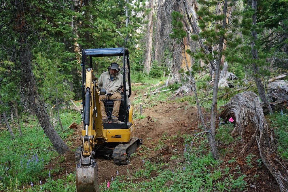
Trailbuilder Ron Murray operates a small excavator in July 2021 as he digs out new sections of Continental Divide Trail near Sublette Pass. (Katie Klingsporn/WyoFile)
There are already some sources of funding for trail building. They include the state’s roughly $2 million-a-year Recreation Trails Program, which is funded through off-highway-vehicle fuel taxes, and a Land Water Conservation Fund of $2.3 million, but those monies can be used for things other than trails. The Wyoming Department of Transportation has a granting program for alternative transportation, though priority is given to Americans with Disabilities Act retrofitting. Wyoming also secured more than $14 million in ARPA and other tourism funds for outdoor recreation, though those are expected to be one-time expenditures.
The idea of mountain bike user fees, Glenn said, comes as the state searches for a self-regenerating source of funding.
Much of the access and trails funding currently comes from the motorized community and the hunters and anglers who pay things like excise taxes, he said. The motorized community, for example, pays the fuel tax that helps fund non-motorized projects through RTP grants.
“And I hear that a lot from the motorized community because they’re going, ‘Wait a minute, we’re paying for this through our gas tax in Wyoming to build non-motorized trails?’” Glenn said. It’s time for the non-motorized community to “have skin in the game,” he said.
The idea also comes as mountain biking becomes a growing economic engine for Western communities, a fact demonstrated in towns like Moab, Utah. According to a 2021 Outdoor Foundation report, Americans’ participation rate in outdoor recreation reached the highest point on record in 2020. Mountain/road/BMX biking was No. 4 on the list of most popular outdoor activities, with 52.7 million participants.
Part of that can be attributed to modern trails that are built specifically for mountain bikers, said Outdoor Recreation Office Manager Patrick Harrington.
Before taking his position, Harrington was superintendent at Curt Gowdy State Park, which has become Wyoming’s poster child for mountain biking’s explosive popularity.
The state started expanding Curt Gowdy’s trail system in 2006, and annual visitation was roughly 50,000 during that time. The park now boasts 35 miles of mountain biking trails. In 2021, Gowdy saw 535,000 visits, according to visitation reports. Roughly 60% of those visitors came to use the trails, Glenn said.
Tried before
A state sticker-fee proposal was put forth a few years ago but did not survive. Only a fraction of the potential funds were earmarked to go back into trails, Rieman recalled. That cost the measure his support, he said.
That proposal’s demise gives Glenn and Harrington more reason to shape the next iteration with ample public input, they said.
“Our interest now is in how do we get [communities’] input up front so that we walk up to the table with 500 people behind this all saying ‘this is a good idea for multiple user groups,’” Harrington said. “We just really want to get behind what the communities want in the outdoor rec world.”
I would way rather see parking fees, and maybe that would at the very least encourage people to carpool to the trailhead. —RIO ROSE, MOUNTAIN BIKER
Rieman will want to know what the administrative element would look like, how fees will be collected and who will have to pay, he said.
“This is a very novel idea of imposing a fee on a specific user group at state parks. I think they’re simply going to have to answer a lot of questions,” he said. “I also am interested, frankly, in something that’s more comprehensive than just the state parks.”
The danger, Rieman said, is that this proposal could actually “get in the way of a bigger and more comprehensive solution.”
Though he has suggested it could be applied to state parks, the concept is not necessarily limited to those places, Glenn said. It could look like a variety of options, from stickers to taxes or entry fees.
He does see an advantage in piloting it in state parks, though. “I think there’s a lot of opportunity there to do it within our parks, expand the systems we have and then build new systems as well.”
Rio Rose owns the Bike Mill shop in Lander and has been heavily involved with trail building in that region. He’s been mountain biking in Wyoming since 2003, and has experienced first-hand the need for funds to build new trails.
“This proposal, it’s something that I think is a really great conversation and it needs to happen,” he said. But his personal contention with a user-fee, he said, is that it could single out mountain bikers.
A mountain biker rides the Beck Lake Mountain Biking Area near Cody. (Nancy Patterson/BLM Wyoming/FlickrCC)
“We’re not the only people using these trails. We’re not the only people causing damage to these trails,” he said. “But we are about the only people doing work on them and pushing to get them put in.
“And so seeing mountain bikers singled out as a user group, where we have to pay to play but nobody else does, rubs me the wrong way,” Rose said. “I don’t think anybody in the mountain biking community is opposed to paying a fee to use trails. I think everybody in the mountain biking community clearly is opposed to being singled out as a user group.”
Rose feels there are better solutions that could tap a broader base of users. “I would way rather see parking fees, and maybe that would at the very least encourage people to carpool to the trailhead.”
Act now or be overrun?
Glenn floated the idea to the Legislature’s Joint Travel, Recreation, Wildlife & Cultural Resources committee in May, and also brought it up to the Wyoming Trails Advisory Council that month. If it moves forward, he told WyoFile, the Legislature wouldn’t consider making it an interim topic until next year.
“That gives us a year to go out and shake the tree a little bit,” he said.
The Outdoor Recreation Office plans to hold listening sessions around the state. “It will be very broad,” Harrington said. “We’ll hit all the major outdoor rec communities and probably several of the smaller ones, with lots of advertising behind it.”
During the trails council meeting, Glenn said that when Moab was first inundated with bikers, it didn’t have the infrastructure to handle the demands.
“We’re at that cusp right now in Wyoming,” he said. And while the state doesn’t have the ability to simply turn people away, he said, “what we do have control over is how we manage these people when they come in.”
Bert Miller of Cody, who chairs the trails council, told the group he favors the idea of bike user fees. Wyoming, he said, is “actually a little bit behind the eight-ball on it, because this all came fast.”
Katie Klingsporn is WyoFile’s managing editor. She is a journalist and word geek who has been writing about life in the West for 15 years. Her pieces have appeared in Adventure Journal, National Geographic Adventure and Patagonia’s Cleanest Line blog.
WyoFile is an independent nonprofit news organization focused on Wyoming people, places and policy.
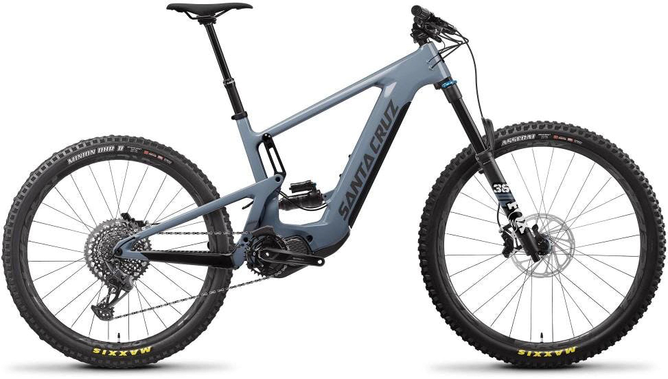
Name of Product: Santa Cruz Bicycles 2022 Heckler 9 Electric Bicycles
Hazard: The latch mechanism that holds the battery in place can malfunction, causing the battery to dislodge from the frame and fall to the ground, posing a fall hazard to the rider. Additionally, the latch spring can cause additional wear on the battery housing over time, posing a fire hazard.
Remedy: Repair
Consumers should immediately stop using the recalled bicycles and contact their authorized Santa Cruz Bicycle dealer to arrange for a free repair to replace the latch spring mechanism and install a battery wear plate. Consumers who purchased the bicycle online or no longer reside near their dealer should contact the firm or visit http://santacruzbicycles.com/dealers. Consumers should remove or secure the battery prior to transporting the bicycles. The firm is contacting all known purchasers directly to provide more details about the repair.
Consumer Contact: Santa Cruz Bicycles toll-free at 833-944-8335 from 9 a.m. to 5 p.m. PT Monday through Friday.
Recall Details
Units: About 1,600
Description: This recall involves 2022 Santa Cruz Heckler 9 model electric bicycles (e-bikes), which were sold in Gloss Avocado Green or Maritime Gray colors. They come with an interchangeable 720WH battery that sits inside a black case under the frame. The name “SANTA CRUZ” is printed on the sides of the downtube of the bicycle frame, and “Heckler” is printed on the top tube of the frame and on the inside of the left chainstay on the frame.
Incidents/Injuries: Santa Cruz Bicycles has received 10 reports of batteries falling from the frame and two reports of the latch spring causing added wear on the battery housing. No injuries or fires have been reported.
Sold at: Online at santacruzbicycles.com and at bicycle shops and sporting goods stores nationwide from January 2022 through March 2022 for between $8,200 and $13,300.
Manufacturer: Santa Cruz Bicycles LLC, of Santa Cruz, California
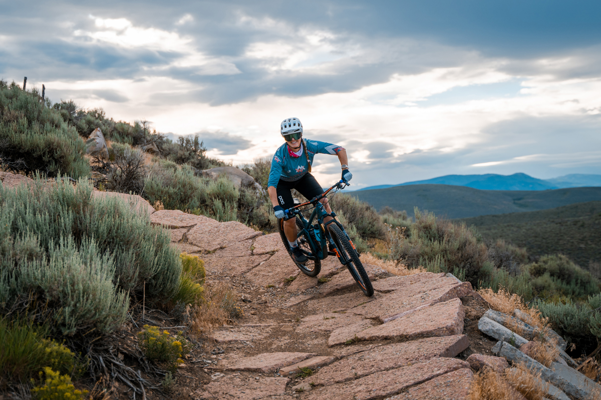
By Erica Tingey — One side effect of a global pandemic is that trails everywhere have attracted record numbers of mountain enthusiasts during the past several months. The surge in trail users – including many novices – has led to increased injuries, collisions, and environmental damage. Because of this, now is a suitable time for a refresher on trail etiquette. Keep in mind that mountain bike access to trail systems is largely contingent on safe and respectful behavior, as well as cooperative relationships with other dirt surfers.
Erica Tingey cornering. Photo by Alex Knight
Respect the yield triangle
Mountain bikers often share trails with hikers, joggers, and animals on multi-use trails. Riders must yield to pedestrians and horses, and downhill riders should yield to uphill riders. Follow local rules where available, and always adhere to instructions for directional trail segments. Ride only trails that are open and legal.
Respect other trail users
If you want to pass somebody, communicate politely and well in advance. Call out “Rider up” or “on your left,” and wait until it is safe to pass – don’t be so focused on your Strava stats that you endanger others. Using a bell can also come in handy, as sometimes it can be hard to hear a bike approaching. When crossing paths, let others know how many are in your group. Move completely off the trail if somebody faster than you wants to pass, even if it stings a little that they are faster than you!
Respect the landscape
Ride only trails that are dry, as riding in mud can cause extensive trail damage. If mud is sticking to your tires, turn around and try to find another trail. Ride or walk through the center of puddles to avoid widening single-track trails and follow Leave No Trace principles – pack it in; pack it out.
Respect your limits
We all have an inner Danny Macaskill, but it’s important to develop awesome bike techniques the old-fashioned way instead of sending it off five-foot drops the week after you start mountain biking. Always ride in control, and never take a corner blindly. Riding too fast or tackling features far above your skill level not only puts you at risk, but also other trail users and potentially Search and Rescue workers. A fantastic way to build your skill repertoire quickly is to take a class from a certified mountain biking coach! Always carry a first-aid kit and basic bike tools and know how to fix a flat.
Respect the weather
Be a self-sufficient mountain biker and come to the trail prepared. If you’re not familiar with the route, research the trail beforehand and carry a map (or download an app like Trailforks, Alltrails, or MTB Project). Check the weather in advance and avoid riding in dangerous conditions. Bring enough food and water for the journey, as well as proper layers for the weather. Showing up unprepared puts yourself and others at risk.
Respect the trails
Since it is spring in Utah, the trails may LOOK like they are rideable, but you may actually ruin them by riding them. Be sure you check out your local trail associations that have up to date conditions for each area. In Park City, you can check with Mountain Trails Foundation and Basin Recreation. In Kamas, check with the South Summit Foundation. In Heber, check with the Wasatch Trails Foundation, and in Draper, the Corner Canyon Trails Foundation. On Facebook there is a page dedicated to trail conditions around Utah, it is called “Utah Mt. Bike Trail Condition Network”.
Have fun and be an ambassador for mountain biking. Simple principles of courtesy and respect go a long way toward building a harmonious, healthy, and happy mountain community!
Stay safe out there and see you on the trail!
Erica Tingey is the head coach of Women in the Mountains, a mountain bike skills coaching company for adult women. She and her coaches hold clinics in Park City and St. George, Utah. For more riding tips and clinic information, follow @womeninthemountains on Instagram and check out our website, womeninthemountains.com.